With the snow from Saturday’s storm yet to fully melt, another round of white stuff is ticketed to move into the region tonight. We give our snowfall forecast, and look forward to the week ahead.
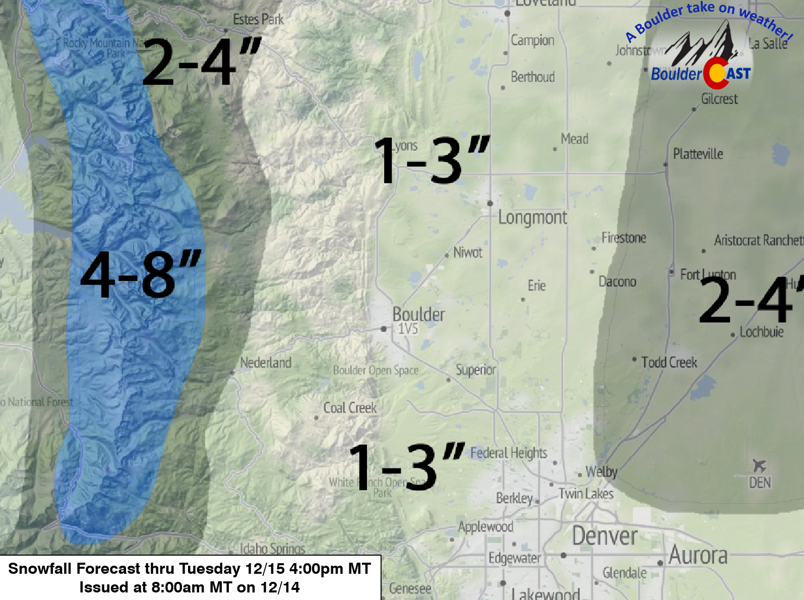
Update (12/14/15 at 10pm MT): The models have been trending slightly more snowy for Boulder County over the last 12 hours, bringing in a more favorable upslope direction to the low-level winds. The heaviest snow was forecast to be well to the northeast of Denver Metro. However, while that will still likely be the case, it now appears more significant snow may shift westward. The National Weather Service has issued a Winter Storm Warning for the Plains across all of Denver Metro, calling for 5-10″. While we definitely agree that our forecast from earlier today is now probably too low, 5-10″ seems just too high. We could see that northeast of Denver. For Boulder, we think 4-6″ is more probable. The Foothills will benefit significantly from the wind shift. 5-10″ there seems like a safe bet at this point. We hate flip-flopping a forecast at the last minute, but we thought it was significant enough to mention. Tuesday morning commute may well end up being an utter mess. Stay warm!
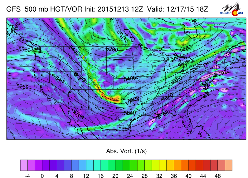
Today will be a day of transition, as our most recent storm makes its way into the Great Lakes, and our next storm system approaches. Both are visible below on today’s 500 mb vorticity map from the GFS.

GFS 500mb vorticity map for this afternoon, showing the exiting system (right) and the storm responsible for tonight’s snow (left).
Between the two systems there is a shortwave ridge, ushering in southwesterly flow aloft. This will warm us up nicely, into the mid 40’s this afternoon.
Enjoy the warmth while it lasts! In association with the 500 mb trough, the models are all indicating a quickly-developing surface low somewhere in eastern Colorado this evening. As it develops, cold air will be drawn southward, knocking our temps down into the mid 20’s after sunset before the precipitation arrives.
Here is the positioning of the surface low from the GFS (at 5am Tuesday).
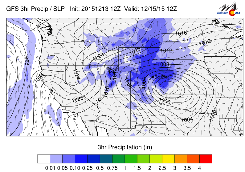
GFS sea-level pressure and precipitation, valid at 5am Tuesday.
In that position, the area near the Wyoming border and the far northeastern corner of the state would make out better than Boulder. The NAM did have the low forming further north by about 100 miles, pushing the heaviest snow into southeast Wyoming. It has since come more into line with the GFS and Euro. Both scenarios bring some snow to Boulder, anyways.
The jet will not be a factor this time (see below), so we don’t expect much in the way of heavy, banded snow. The main forcing will be general synoptic lift (from the trough) and low-level upslope (from the surface low)
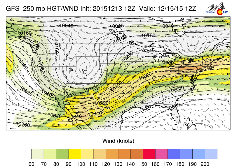
GFS 250mb height and wind speed for Tuesday morning. Not only is the jet too far south to impact us, it is very elongated and broad.
Light snow will break out in the Mountains later this afternoon, but won’t make it down low onto the Plains until around midnight. Somewhat favorable upslope (NNE-erly) is present then and lasts at least until around noon tomorrow. With a significant northerly component, the winds tend to come down from the Cheyenne Ridge (piece of topography running east-west, just north of Ft Collins. This northerly downslope can counteract the easterly upslope. Quite complicated terrain effects in our area to say the least.
After that, as the low pulls further east, Boulder County moves into a regime of strong subsidence. This should bring snow to and end, likely early afternoon Tuesday.
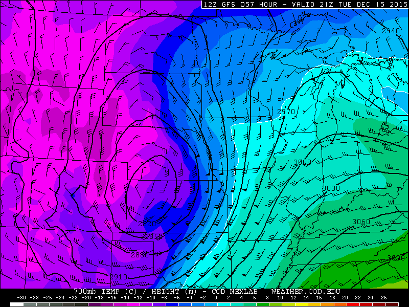
GFS 700mb temperature, height, and wind for Tuesday afternoon, showing strong subsidence across north central Colorado
As for snow amounts, this system is looking quite similar to the last event, though it is running a few degrees colder. The GFS accumulated precipitation forecast (shown below) summarizes things well. You can see the bulls-eye of lower snow from Denver, up through Ft Collins and Greeley, caused by the Cheyenne Ridge downsloping. We also see the indication that the heaviest snow totals will remain north and east of Denver.
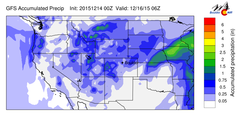
GFS accumulated liquid precipitation through Tuesday evening.
Without the heavy banding, and considering the track of the storm and downslope from the Cheyenne Ridge, we expect snow totals to be slightly lower than last week’s storm. The GEFS and SREF are both hinting at 0.1-0.4″ of liquid for Boulder County. Our forecast map is given below, with a general 1-3″ across the Plains, and 2-4″ in the Foothills and areas northeast of Denver.
For the rest of Tuesday, we will stay mostly cloudy and cold. You are used to this now, right? Temperatures won’t get out of the 20’s.
Wednesday will be under northwesterly flow. While light snow will continue in the Mountains, the lower elevations east of the Divide will be dry. Clouds will still fill most of the sky through the day, preventing too much warm-up. Low 30’s are a good bet.
Moving into Thursday, a weak, quick-moving trough will slide down from Canada, bringing a chance of extremely light snow (mostly for the Mountains) and a reinforcing shot of cold air. You can see this system below, diving into the Texas Panhandle.
GFS 500mb vorticity map for Thursday, showing a small-scale trough sliding through Colorado.
The time frame for snow will be throughout the daytime hours on Thursday. We expect just flurries on the Plains/Foothills, with an inch or two in the Mountains. Highs will be cooler than Wednesday, only in the mid to upper 20’s.
For Friday, and heading into the weekend, a ridge returns to Colorado, with more sunshine and moderating temperatures (especially Saturday and Sunday!). Under northwesterly flow, Friday will in the low 40’s, with 50’s to follow for the weekend.
GFS 500 mb vorticity map for Friday, showing a sizable ridge across the West.
Happy Monday! Have a good week.
The Forecast:
Monday: Some sun early, with increasing clouds through the day. Highs in the mid 40’s on the Plains, with upper 30’s in the Foothills. Light snow arriving late evening.
Tuesday: Snow showers early, tapering off around noon. Cold and cloudy with a few peaks of afternoon sun. High temperatures in the mid 20’s across the Plains, with upper teens in the Foothills.
Wednesday: Mostly cloudy and cool. Highs in the upper 30’s on the Plains, low 30’s in the Foothills.
Thursday: Mostly cloudy with isolated snow flurries/showers. Little to no accumulation expected (except in the Mountains, where an inch or two may be possible). Highs in the upper 20’s across the Plains, mid 20’s in the Foothills.
Friday: Partly sunny and mild. High temperatures in the mid 40’s for the Plains, with upper 30’s in the Foothills.
Extended Outlook: A ridge builds in for the weekend, bringing tranquil, sunny, and warm weather for everyone. The Plains will be in the 50’s on both Saturday and Sunday.
Source
Mon
Tue
Wed
Thu
Fri


BoulderCAST
43
28
34
29
44


NWS
43
29
30
27
40


AccuWeather
40
29
33
26
42


The Weather Channel
42
28
33
30
47
Last week’s recap:
Here are the results of last week’s forecast. First, the forecasts and observations from all of the sources:
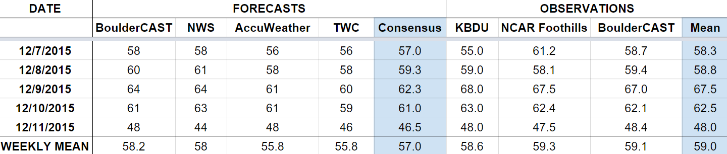
Last week was dominated by warm westerly, downslope flow (a Chinook pattern). Temperatures were way above normal. Finally though, a trough arrived and brought a big cool down and snow Friday night. We predicted 1-3″ of snow for the city of Boulder. 3.3″ was officially recorded. Read our forecast review of the storm for more details.
Let’s look at the error analysis. Shown below is the amount of degrees (in Fahrenheit) that each source was off from the mean observed temperature for Boulder. Positive values indicate the forecast was warmer than what actually occurred, while negative values arise from a forecast that was cooler than what was observed.
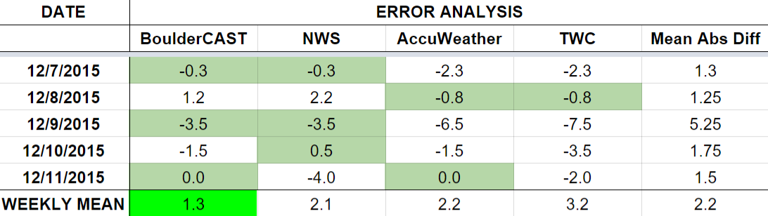
The worst forecast day of the week ended up being Wednesday, with more 5 degrees of error averaged across the board. Temperatures warmed to 67 degrees (above the forecast of 62). It was still surprising it got that warm, as skies were completely cloudy that day. The magnitude of the warming from downslope is always challenge. Every other day of the week was forecast great!
The bottom row of the error table shows the weekly mean error for each weather outlet, a good measure for who was the best and more consistent “forecaster” for the week. BoulderCAST returns to first place, with just over 1 degree of error per day.
As a sneak peak to an upcoming post about forecast accuracy, in the 23 weeks we have been doing “Week Ahead” forecasts, BoulderCAST was first 9 times. The NWS and AccuWeather have each won 6 times, while The Weather Channel only got first twice. Look for a more detailed comparison and comments in the near-future!


You must be logged in to post a comment.