After a gorgeous Sunday across the entire Boulder area, the heat returns as the ridge of high pressure rebuilds from the south. By midweek, a system approaches, bringing a chance of storms back into our forecast. The past week has also been quite hazy/smoky, most prominently on Saturday. When will the smoke clear? Read on to find out!
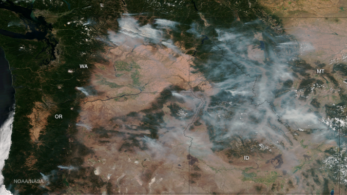
Before we discuss the week ahead, we want to discuss the haze we have seen in Boulder County this week. This is all due to a large amount of wildfires burning across the Pacific Northwest. We briefly discussed this in last week’s post as well. The satellite image shown above depicts the smoke connected with these wildfires. Below highlights the location of actively burning fires, mostly across Washington, Oregon, Idaho, and Montana.
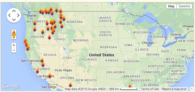
Current wildfires across the United States | Inciweb.org
A cold front moved through Saturday, which brought northerly winds from Wyoming and Montana into northeast Colorado. This cooler airmass also contained the smoke from the wildfires in the Pacific Northwest which increased the amount of haze across our area. The reduced visibility should improve as we go through week, but may return Thursday alongside another cold front.
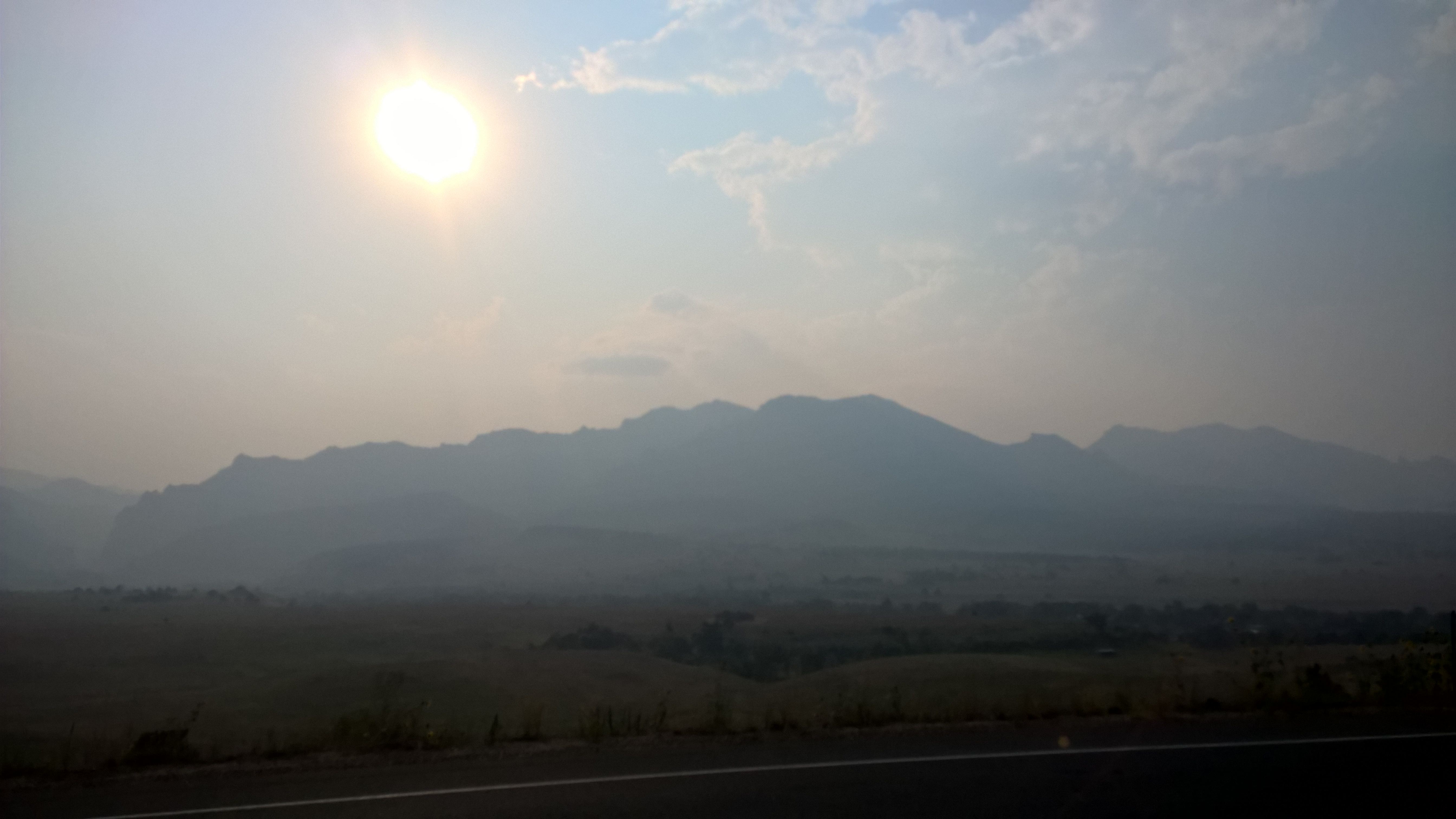
Very smoky landscape | Aug 22, 2015 | South Boulder
After a cool and spectacular Sunday with highs in the mid 70s, the ridge of high pressure builds back into Colorado on Monday (shown below).
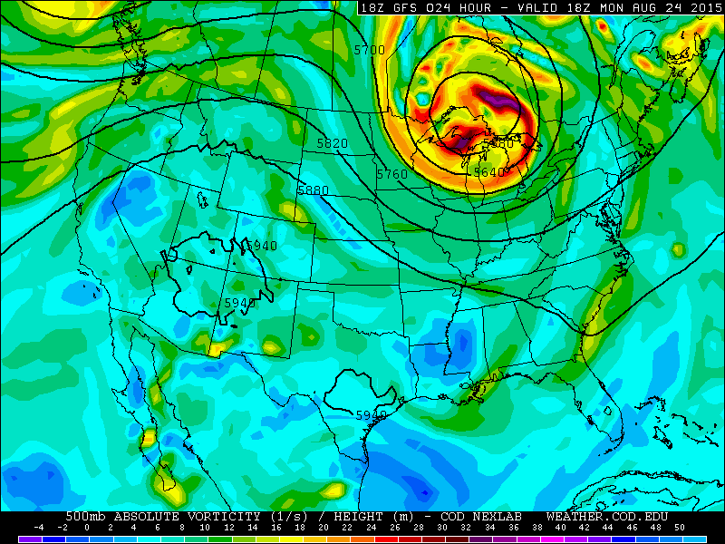
500 mb absolute vorticity and heights for Monday from the GFS model, showing the rebuilding ridge across the West.
The ridge is located over the four corners, with a trough across the upper Midwest. This trough was responsible for the cold front Saturday which funneled in the smoke from the Northwest. This ridge should lead to temperatures rising back into the 80’s in most areas on Monday. The upper-level flow is still from the west and northwest, so there will likely still be some smoke and haze around, but the visibility should improve as the day wears on.
On Tuesday, the dome of high pressure further anchors itself across Colorado. Shown below is the 500 mb pattern for Tuesday. This will lead to further warming, well into the 90s across the plains and upper 80s in the Foothills. The 700 mb temperatures are also shown below. These temperatures are near 18 degrees Celsius for Boulder County, which supports low to mid 90s in the city of Boulder. With the ridge building in, this will slowly lead to winds becoming less from the west and northwest. This means the visibility and overall air quality should improve even more on Tuesday, with a better view of the majestic mountains!
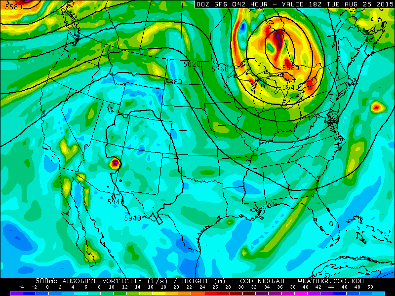
500 mb absolute vorticity pattern for Tuesday from the GFS model
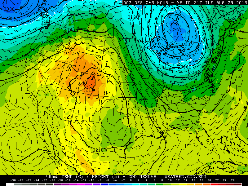
700 mb temperatures for Tuesday from the GFS model
On Wednesday, the forecast models have been consistent in showing an upper-level shortwave approaching from the southwest. This system starts out over Utah on Wednesday, but rapidly moves into the Dakotas by Thursday. This feature can be seen in the 500mb absolute vorticity plot below, with a large amount of positive vorticity advection Wednesday afternoon and evening.
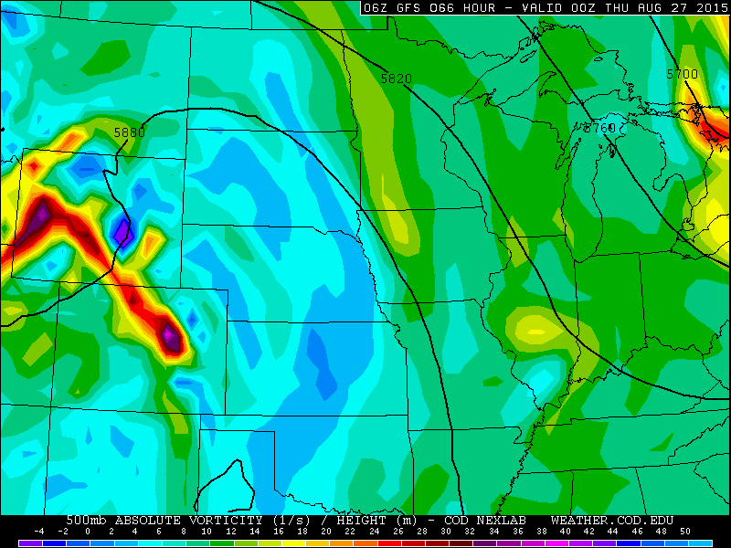
GFS model 500mb vorticity map, valid at 6pm Wednesday
Normally, this would introduce a decent chance of storms into our forecast. And indeed, this is exactly what is seen in the below precipitation forecast from the GFS model. It shows a large amount of storm activity across southwestern Colorado and the High County. If you’re planning to hike on Wednesday, be sure to start early to avoid being caught in a storm. However, over Boulder County, the chance of storms is diminished, as a downslope flow ensues helping to stabilize the atmosphere. There will be a few passing storms, but we should remain dry for the most part, with the best chance of rain over the Foothills.
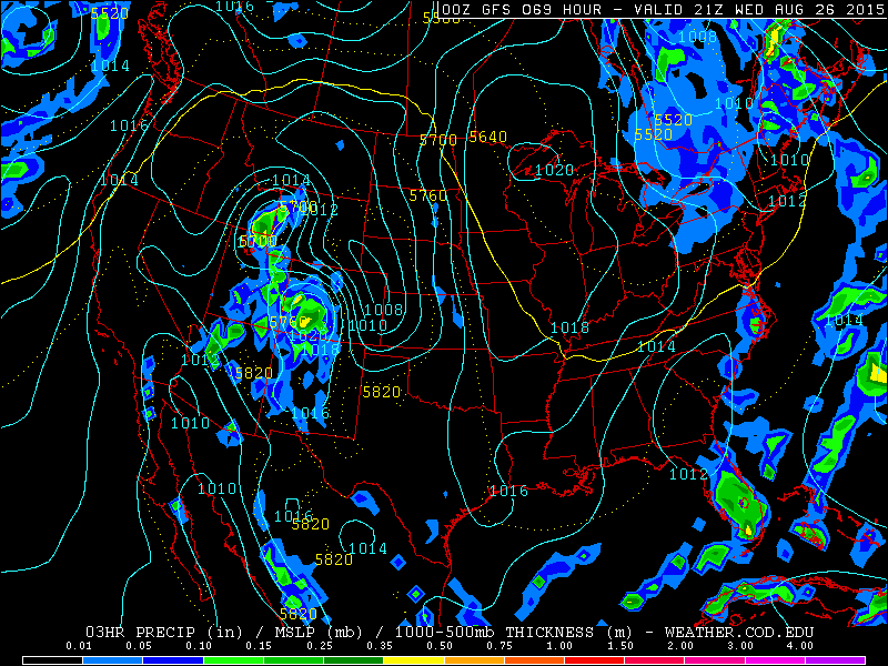
GFS mean sea level pressure and precipitation forecast for Wednesday
This low pressure system on Wednesday drops a cold front through Thursday morning, as shown in the 850 mb temperature, wind, and height pattern. The center of the system will be over western Nebraska, with a cold front trailing to the southwest of the system into northeast Colorado, as evident by the northerly winds. These northerly winds will bring down more smoke from Montana for Thursday, so its likely that the hazy conditions could return. Temperatures will also be cooler with little chance of rain.
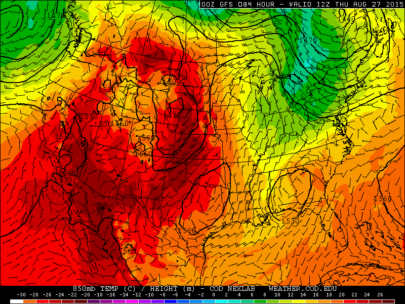
850 mb temperature, wind, and height pattern from the GFS model
On Friday, the ridge of high pressure builds back in and we return to the 90s with dry conditions.
Your forecast for the week ahead:
Monday: Mostly sunny with highs into the upper 80s on the Plains, with mid 80s in the Foothills. There will be a few isolated storms in the High Country but dry elsewhere.
Tuesday: Hot and sunny with high temperatures in the low to middle 90s on the Plains, with upper 80s in the Foothills. A few isolated storms are again possible in the High Country.
Wednesday: Sunny skies, followed by increasing clouds in the afternoon. A few isolated storms will be possible on the Plains with scattered storms in the Foothills. Highs in the upper 80s on the Plains with lower 80s in the Foothills. Storms will be numerous in the Mountains during the afternoon and evening.
Thursday: Cooler with partly cloudy skies. Highs in the lower 80s on the Plains and upper 70s in the Foothills. Just a slight chance of a few storms across the Foothills.
Friday: Mostly sunny and hot weather returns. Highs in the lower 90s on the Plains with mid to upper 80s in the Foothills.
Source
Mon
Tue
Wed
Thu
Fri


BoulderCAST
89
94
89
84
90


NWS
89
92
88
85
86


AccuWeather
91
93
88
85
88


The Weather Channel
90
92
87
84
84
Last week’s recap:
Here are the results of last week’s forecast. First, the forecasts and observations:
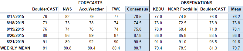
The consensus was for a cool beginning to the week, with a good chance of rain on Monday through Wednesday, including both severe and winter weather for Boulder County. Thursday and Friday were expected to be drier and see temperatures rebound back to near 90 degrees.
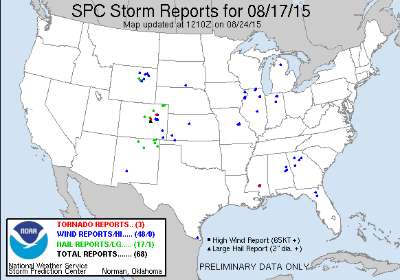
BoulderCAST anticipated some severe weather on Monday, but mostly south and east of Boulder County. That verified quite well, with a Tornado Watch encompassing the region, and two tornadoes touching down. Numerous cells also dropped 1 to 2″ diameter hailstones. The storm reports for Monday, Aug 17th are shown below.
We also tipped you off that snow may be possible early Wednesday morning in the highest elevations. While we couldn’t find any direct observations of snow in Boulder County, the mountains from Larimer County northward did pick up a light dusting! Winter is right around the corner for the Mountains..
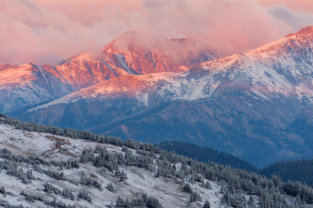
Early snow | Rocky Mountain National Park | Aug 19, 2015 | Photo credit: Thomas Mangan
Now the error analysis. Shown is the amount of degrees (in Fahrenheit) that each source was off from the mean observed temperature for Boulder. Positive values indicate the forecast was warmer than what actually occurred, while negative values arise from a forecast that was cooler than what was observed.
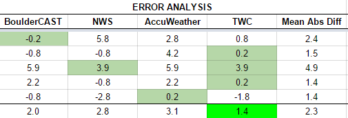
The temperature trend generally went as expected, though all forecast outlets really under-estimated the cooling behind the cold front for Wednesday, with an average forecast value nearly 5 degrees too warm, even with sunny skies. Otherwise, errors were on par with what is to be expected. Running the numbers, BoulderCAST had the best forecast only on Monday, with The Weather Channel doing the best three days this week.
—
If you haven’t already done so, follow us on Twitter or Facebook for frequent weather updates and subscribe to the site to get these posts automatically delivered to your email box (enter your email in the sidebar widget to right).


You must be logged in to post a comment.