Over the last 48 hours, little has changed with the storm. The Front Range is still on track to pick up a decent dumping of snow on Monday, with amounts and timing starting to become a little bit more clear. Read on for our current thoughts, as of Friday evening.
Consistency is there
In the two days since we last posted about the upcoming winter storm, not much has changed. Models have remained relatively consistent with both the intensity and track of the storm. With that consistency, our confidence has increased a tad. However, the arrival is still more than 60 hours out, so some fine tuning will likely take place.
We know that a powerful storm system will come ashore in California Sunday evening, moving across the Four Corners and into southern Colorado by Monday afternoon.
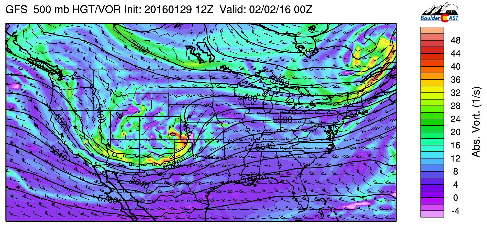
GFS 500mb vorticity map valid Monday at 5pm showing the trough responsible for the storm.
It will rapidly intensify to our south and produce a large band of heavy snow and blizzard conditions. Within this heavy band, snow totals will likely exceed 1 foot! Based on all the current model guidance, the track of the system will probably just be a little bit too far south to reach entirely into Boulder and Denver. However, snow lovers will be happy to know that we should still pick up significant snowfall!
Main impact: Persistent light to moderate snow
With the best dynamics remaining to our south, the biggest factor for our region will be the combination of prolonged upslope and plentiful moisture. Ordinarily, when a system tracks this far south, Boulder would only get a brief shot of upslope before the winds quickly switch to northwesterly (downslope) as the low pressure tracks toward Kansas.
Although in this instance, as the 700mb low moves into western Colorado, it weakens and then transfers energy to a rapidly intensifying low in SE Colorado. Lee cyclogenesis is pretty bad ass! This type of transition is something we don’t always observe on the Front Range, but frequently occurs during Nor’easters (as the main low in Ohio Valley transfers energy to the rapidly deepening coastal low). The pressure field left behind from the weakening low in western Colorado will keep our upslope going for an extended period of time. You can see this transition below. Pay particular attention to the direction of the wind in Denver throughout as well.

700mb height and temperature map showing the evolution of upslope across the region during the event. The redevelopment of the low over SE Colorado is evident as well.
Southeasterly upslope begins Monday morning, shifting to easterly by the afternoon, and to northeasterly by Tuesday morning. This is also apparent in the time height plot below, which also shows that the upslope extends up to near 500 mb at times.
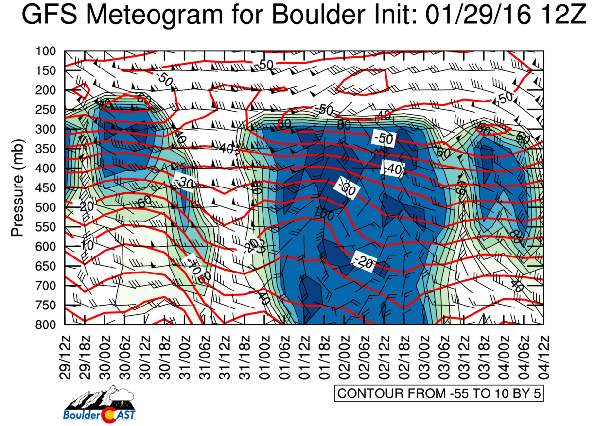
Time vs. height plot of RH, temperature, and wind speed/direction for Boulder. Notice the deep upslope up to 550mb during the height of the event (around 0z on Feb 2nd)
Upslope is present from about sunrise Monday into Tuesday afternoon. Snow will likely be falling across Denver Metro most of this time frame, about 24 to 30 hours straight! You can imagine how that will add up. Even with light snowfall rates near 1/4″ per hour, everyone should be able to pick up at least 6 inches. Favorable locations like the Foothills and even the city of Boulder should do much better that that.
Here is the current GFS snowfall forecast map for the state:
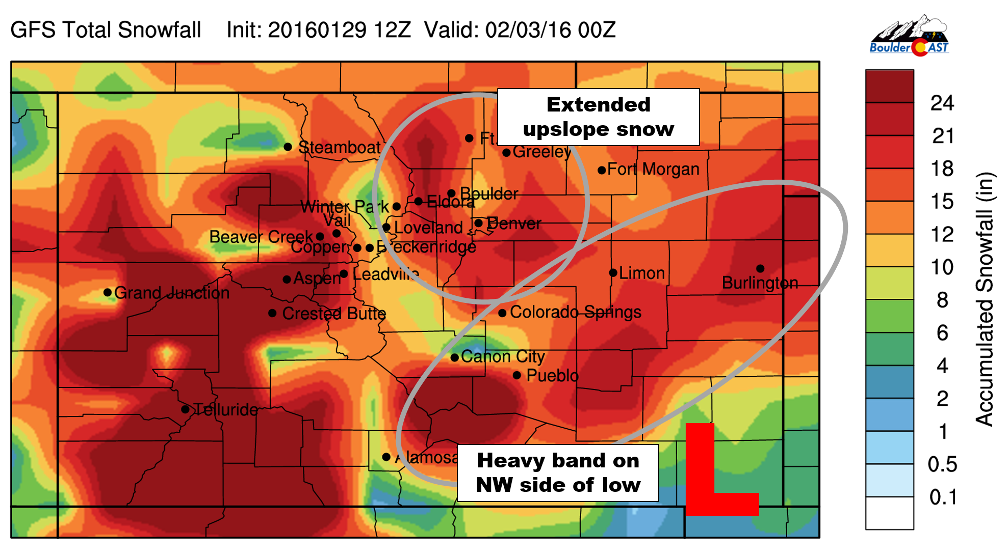
GFS forecast snowfall through Tuesday evening for Colorado. Hefty snow totals are possible almost everywhere!
And the GFS ensembles for precipitation amount:
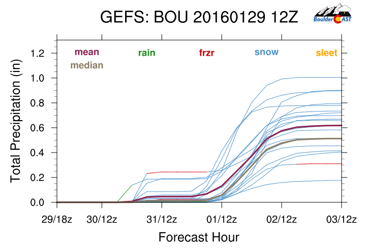
The mean of the 20 model runs is just above 0.6″. This equates to about 9″ of snow (using a 15:1 ratio, which may be too conservative). The NAM is similar (though doesn’t capture the tail-end of the event, since it only runs out 84 hours), while the Canadian brings just a little less.
In summary:
- Were are very confident the storm is going to happen! Models are consistent in both track and intensity.
- Snow beginning for the Metro area Monday morning, persisting into Tuesday morning. Heaviest Monday afternoon and evening
- There will be a very heavy band of snow near the core of the low, but that should stay south and east of the region
- We are confident that everyone should see at least 6″
- The Foothills and Palmer Divide have a very good chance to exceed a foot of snow. Adjacent Plains, including the city of Boulder, can’t be ruled out either for 12+”
- For now, we won’t toss out any final snow amounts. It is still too early to make that call
We’re still sixty hours out from the first flakes. There is still time for things to change a bit. We’ll definitely pass along updates if needed, and issue our final forecast during the day Sunday! Let’s just say things are looking pretty good for our biggest dump of the year!
Enjoy Saturday’s warmth and brace for a rude awakening of snow on Monday! Don’t forget to subscribe to BoulderCAST! We have a feeling the Live Blog may be necessary, as well.


You must be logged in to post a comment.