Wow! It’s been a busy Monday morning with our winter storm coming ashore into the Pacific Northwest overnight. We discuss the latest from the weather models this morning and ultimately why we believe historic snow totals are likely from Boulder north to Fort Collins.
Historic snow totals possible in some areas
Based on the latest satellite imagery, the approaching storm system has just in the last few hours come ashore into Oregon and is making its way towards Colorado right now. The wave is still rather weak so it’s difficult to pinpoint exactly in the GOES-East satellite animation below. It’s somewhere in eastern Oregon or Idaho. Over the next 24 hours, the storm will rapidly gain strength and soon enough become very easy to identify from space! The initial wave of cooler air is sagging southward into northeast Colorado this morning. Highs will only be in the middle to upper 30’s today…chilly compared to the 60’s of yesterday.
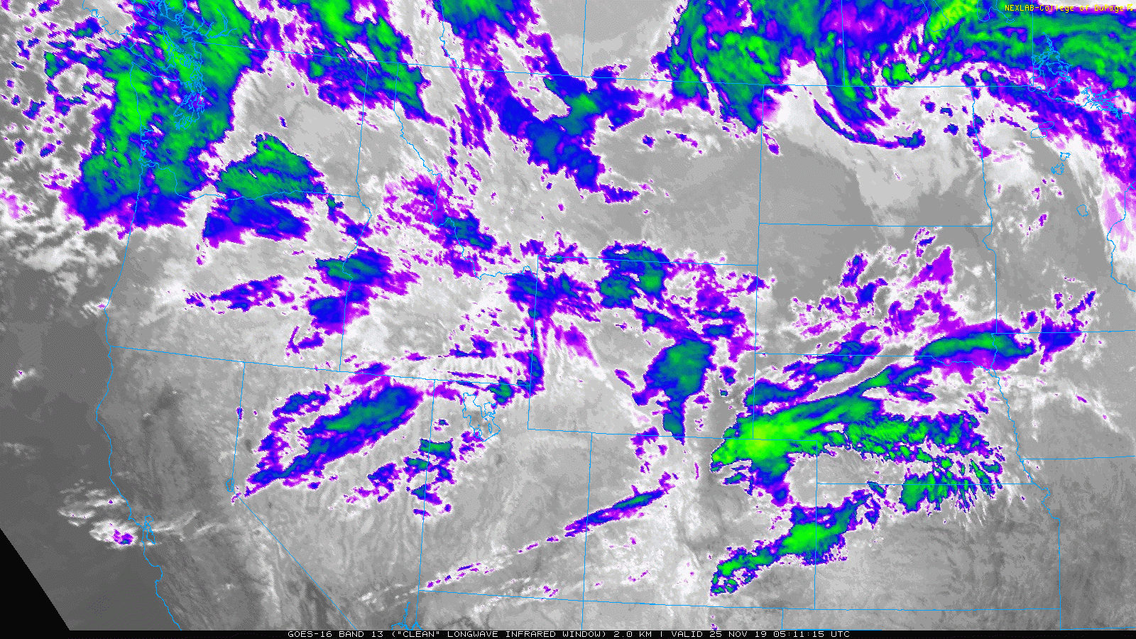
GOES-East infrared satellite animation showing our storm coming ashore in Oregon Monday morning
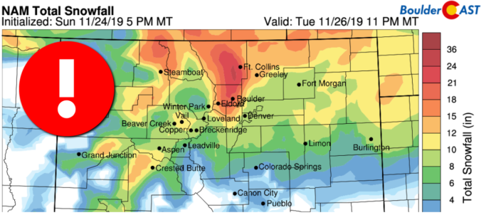
Things go downhill quickly this afternoon into early evening from north to south as all of the ingredients for heavy snow begin to come together across the northern and western Front Range. Since our forecast update yesterday, the weather models have remained consistent in their predictions for the area in general, though a slightly slower storm is indicated. We have seen continued support for BIG snow totals north and west of Denver, especially in Boulder and Larimer Counties where “EPIC” snow totals may be more appropriate. By applying our custom adaptive snowfall algorithms to the latest runs of the GFS and NAM models (below), we see very good agreement for 7-14″ in Denver and 12-24″ from Boulder northward! As we indicated yesterday, Boulder, Longmont, Loveland, and Fort Collins will be hit hardest with extremely heavy snow.
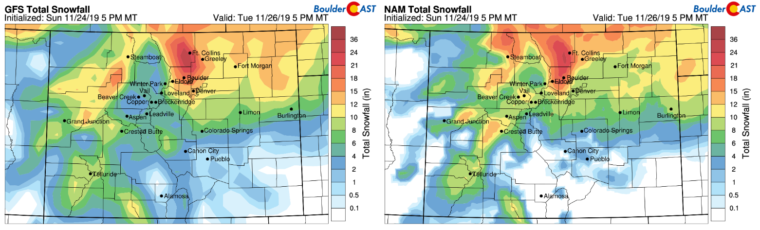
GFS (left) and NAM (right) model-derived total snowfall forecast through Tuesday evening
As the short-range models begin to capture the full extent of the storm, we see this precise solution confirmed. For those that love snow, this is the final nail in the coffin! Here’s the latest HRRR snowfall forecast:
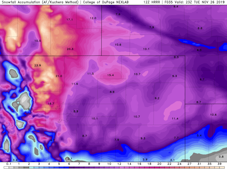
Total snowfall forecast through Tuesday evening from the HRRR model
A key reason for the big snow totals in and near the Foothills of Boulder and Larimer Counties is enhanced deep upslope flow and the development of a low-level convergence line. There is some indication that a barrier jet will form this afternoon and evening right along the base of the Foothills. This jet leads to strong northerly winds clashing with easterly winds right above the Boulder/Longmont area. As the winds collide, air is forced upward providing extremely concentrated lift. The result of this, localized very heavy snow (2+” per hour), is visible in the HRRR simulated radar animation below. We also see widespread moderate to heavy snow develop region-wide through the overnight hours into Tuesday morning.

Seeing this strong agreement between the global, regional, and high-resolution models this morning is the final piece of a complicated jigsaw puzzle. For this reason, confidence is high that this will be a historic snow storm for northern portions of the Front Range. The city of Boulder has only experienced three storms in the last 130 years that put down more than 16″ of snow in November. Despite our discussion largely focusing on areas from Boulder northward, the entire Denver Metro area will without a doubt see impactful snow totals in the next 36 hours. We discussed the ingredients coming together to make this storm in our forecast update yesterday. The table below puts them all on a timeline for Boulder and Denver. Heavy snow will hit sooner, harder, and longer in Boulder compared to Denver. The darkest hours of the storm will be from 6PM to 6AM in Boulder, and 10PM to 6AM in Denver.

Based on everything we are seeing, we have amended our snowfall forecast map slightly, shown below. The main change was to bump up totals in Boulder and Larimer Counties now that we have elevated confidence in 12+” totals here. It’s conceivable that localized areas in the orange shading could see more than 2 feet. This would be most likely in the Foothills of Larimer County where models are targeting most aggressively.

Travel impacts will be high to extreme Monday evening into Tuesday evening. CDOT has already recommended against travel Monday night and Tuesday. If things go as sideways as we’re forecasting, travel bans may be issued for portions of Boulder, Larimer and Weld Counties. While DIA isn’t expected to see quite as much snow, it’s still plenty to cause a total half on air traffic. This could create a domino effect spilling into the subsequent busy holiday travel days. Good luck if you have incoming or outgoing flights over the next few days. Get out now if you can!
Buckle up, folks! Something truly remarkable is about to unfold for the area tonight! From all of us at BoulderCAST, stay safe, stay warm, stay off the roads!
LIMITED TIME OFFER: Until the snow stops on Tuesday afternoon, use the promo code BIGSNOW to save 25% on BoulderCAST Premium.
We discuss Boulder and Denver weather every single day on BoulderCAST Premium. Sign up today to get access to our daily forecast discussions every morning, complete six-day skiing and hiking forecasts powered by machine learning, access to all our Front Range specific weather models, additional storm updates and much more!

.
Spread the word, share the BoulderCAST snow forecast!


You must be logged in to post a comment.