
Yikes! A surprisingly high amount of uncertainty remains regarding the incoming winter storm making for a difficult forecast heading into Saturday. We provide a quick update, including our team’s thoughts on the most recent model runs and if any tweaks are needed to our prior snowfall forecast (spoiler alert: they are!).
PREMIUM STORM UPDATE (7:00 AM Sat 12/28/19): We do a quick check on how the forecast looks early Saturday as moderate snow falls across the Front Range. We talk forecast amounts, waning snowfall intensity, and gusty winds expected later today. Click HERE to read.
W
e continue to see major disagreement in the models regarding what exactly happens Friday night into Saturday as two potent storm systems come together across Colorado. As of Friday afternoon, the southern and larger of the two storms is located in central Arizona. Its mid-level rotation is visible clear as day in the GOES-East water vapor animation below. This low will track northeast and pass just south of us during the day Saturday.
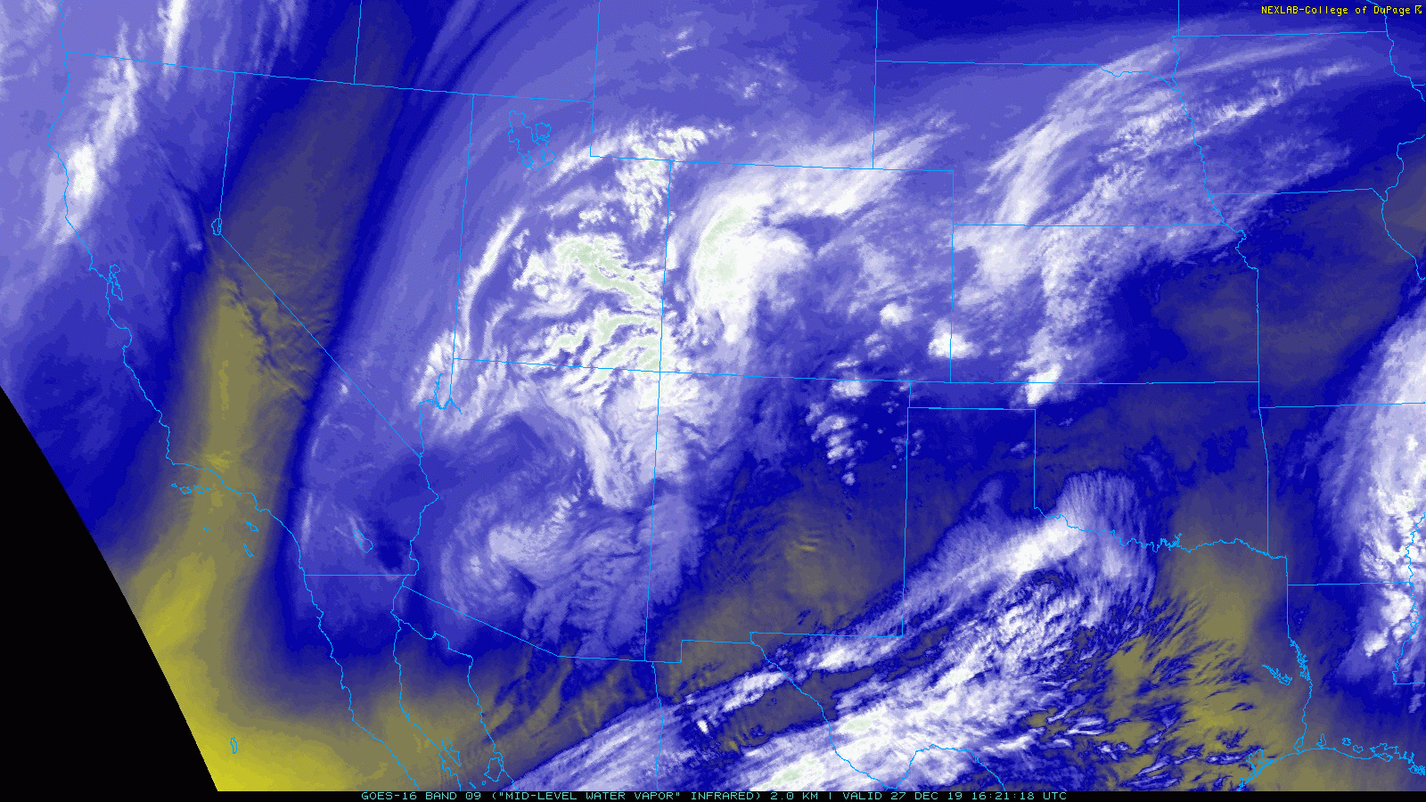
Latest GOES-East water vapor satellite animation from Friday afternoon
Ahead of this circulation, moisture is already pushing into eastern Colorado from the south with a mix bag of precipitation (rain, snow, sleet, freezing rain) falling over the far eastern Plains into Kansas. In the immediate Denver Metro area, it’s cold enough that we’ll be in the snow regime with flurries or a few snow showers possible through the afternoon and evening hours on Friday. Due southerly flow isn’t favorable for Denver or Boulder as it is downslope from the Palmer Divide. Thus, any snow in the next handful of hours will be light and spotty with no real impacts or accumulation.
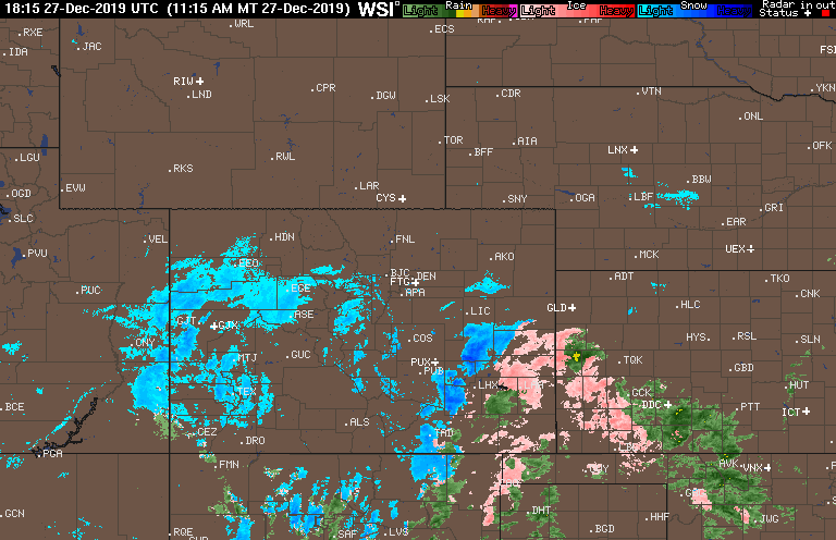
Latest regional radar from Friday afternoon
Over the next 12 to 24 hours, another storm system will drop south from Montana into western Colorado, feeding both colder air and energy into the southern track system just as it arrives to our doorstep. Whether the two storms fully consolidate or remain separate entities is not clear as models continue to struggle with this. Exactly what transpires will obviously have impacts on the Front Range snowfall forecast, and in a broader sense, that for all of eastern Colorado.
Since our forecast update yesterday evening, the models have sadly not wavered from their disagreement. This is making for quite the challenging forecast. On one hand, global models have indeed come into better overall consensus that most of the Front Range will see between 0.2″ and 0.4″ of liquid from this storm. This would support 2-6″ of snowfall. A little higher than we outlined yesterday. Not bad eh? This consensus is now true for the GFS, GFS ensembles, NAM and the Euro models. Their agreement on precipitation amounts may be more of a coincidence than anything, especially considering how starkly different their opinions remain on other key facets of the developing storm.
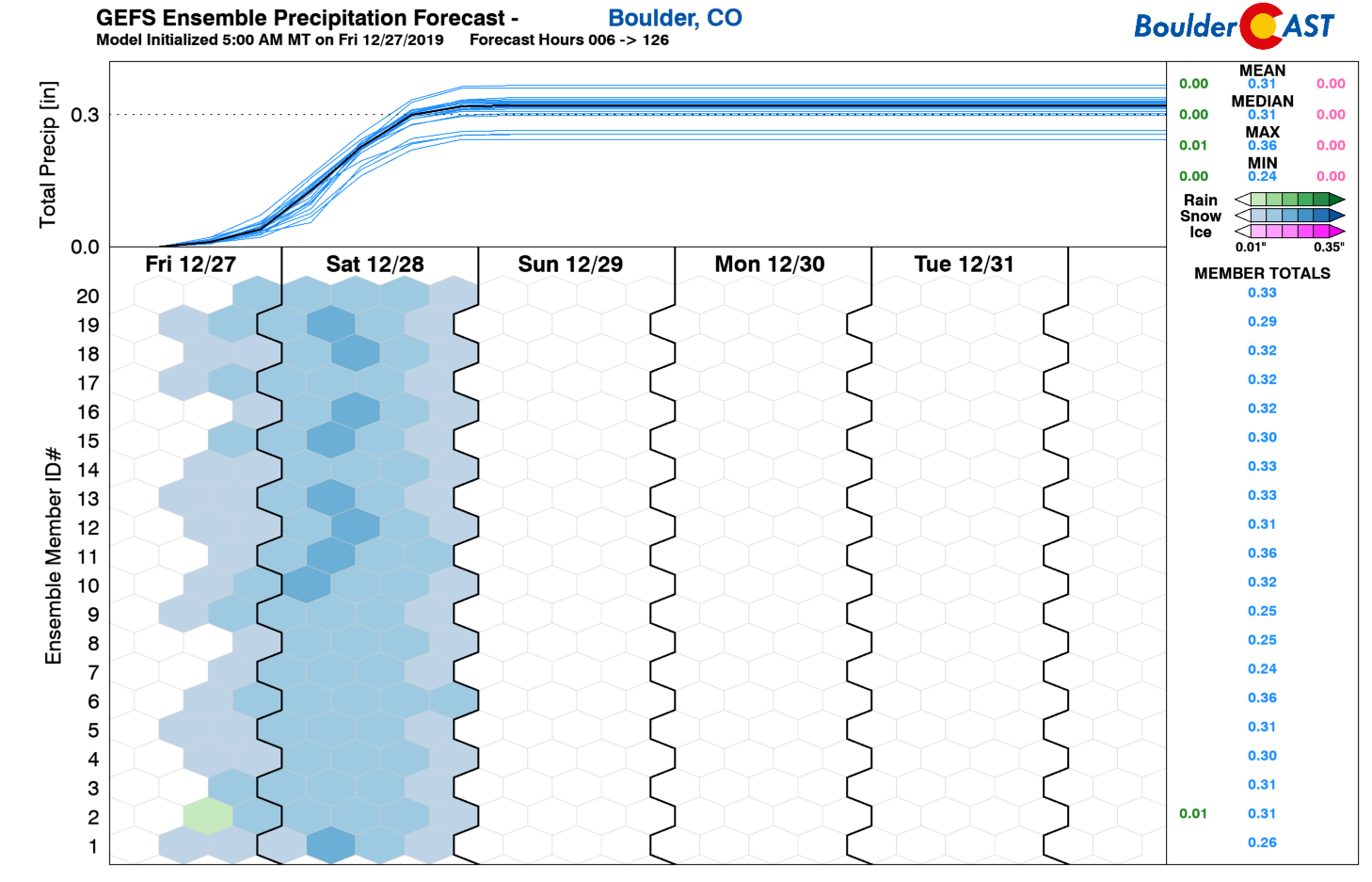
The latest GFS ensemble median precipitation amount is 0.31″ in Boulder which translates to 3-5″ of snow.
Another consideration to entertain is that the high-resolution HRRR model has in its more recent runs started spawning several bands of moderate to heavy snow Friday night after midnight into early Saturday morning directly over Boulder and/or Denver. These bands are not present in any of the global models. Considering the recent variability from the GFS and Euro, we’re more inclined to take the HRRR at its word. These heavy bands appear to be associated with warm/moist southeasterly flow over-running drier/colder northwest flow coming off the higher terrain. The developing band is visible in the HRRR model precipitation forecast animation below. Notice how it remains stationary for several hours over northwest Denver into Boulder. Should this band materialize tonight, a lot of snow could come down very quickly in affected areas with deteriorating travel conditions.
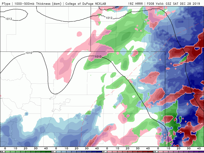
The high-resolution HRRR model is showing potentially heavy bands of snow between midnight and sunrise Friday night. These bands could boost totals
Beyond the potential heavy snow banding overnight, light to moderate snowfall and then flurries will continue into Saturday afternoon and night, especially east of Interstate 25 which will be closer to the developing low. True upslope is limited to non-existent with this storm, so the typically favored areas like Boulder and Golden may not see that all that much snow outside of the aforementioned heavier banding. Areas north of Longmont to Fort Collins will mainly be away from the action and also catch the downslope effects of northerly winds coming down off the Cheyenne Ridge. Both of these factors will lead to those areas seeing the lowest snow totals.
So where does all this uncertainty and disagreement leave us? It’s certainly a cause for concern, one which we were hoping would be rectified by now. Outside of the potential banding, a 2-5″ snowfall forecast should do quite well for the entire Metro area this evening, save for the far southeast which will be a little higher. However, should the banding materialize, localized areas could see up to 8″. All of this is reflected in our updated snowfall forecast map below.

Another aspect of the storm will be the developing strong winds through the day Saturday as the pressure gradient intensifies over eastern Colorado alongside the low pressure. The worst of it will be well east of the Metro area, but still we can expect drifting and blowing snow with winds gusting up to 25-35+ mph in our area. This will certainty cause at least minor travel impacts on roadways with reduced visibility and possibly some flight delays at DIA. Winds will begin to relax Saturday evening and night.
All things considered, Saturday will be a snowy, cold, and blustery day for sure. Prepare for the worst (up to 8″ if you’re extra unlucky), and hope for the best (just an inch or two)! The stretch of cold weather in the coming days following the snow will be some of the worst we’ve had in what has been a relatively warm December thus far.
That’s all for now, but do stay tuned for updates on this complex and still developing forecast.
LIMITED TIME OFFER: Use the promo code HAPPYHOLIDAYS to save 33% on BoulderCAST Premium.
We discuss Boulder and Denver weather every single day on BoulderCAST Premium. Sign up today to get access to our daily forecast discussions every morning, complete six-day skiing and hiking forecasts powered by machine learning, access to all our Front Range specific weather models, additional storm updates and much more!

Subscribe to receive email notifications for BoulderCAST updates:
We respect your privacy. You can unsubscribe at any time.
.
Spread the word, share the BoulderCAST snow forecast!


You must be logged in to post a comment.