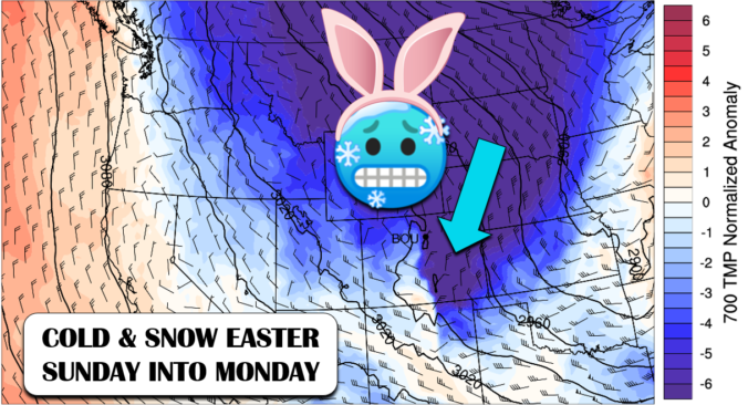
A winter storm is coming to Front Range Colorado just in time for Easter Sunday with temperatures expected to fall nearly 50°F in the next 18 hours. Accompanying the fierce drop in temperatures will be an extended period of snowfall from Sunday morning into Monday. Let’s take a look at forecast snowfall amounts and just how cold temperatures will get in the coming days.
Key Forecast Highlights:
- A sharp drop in temperatures will accompany an Arctic frontal passage late Saturday night
- Prepare for a long-duration, low-intensity snowfall event from Sunday morning into Monday
- Highest totals will be in the Foothills and upslope-favored western Denver Metro area
- 3-8″ Boulder, 1-4″ Denver, 6-12+” Foothills
- Highs in the 20’s Sunday, then 30’s Monday….also overnight record lows possible
Help support our team of Front Range forecasters by joining BoulderCAST Premium. We talk Boulder and Denver weather every single day. Sign up now to get access to our daily forecast discussions each morning, complete six-day skiing and hiking forecasts powered by machine learning, first-class access to all our Colorado-centric high-resolution weather graphics, bonus storm updates and much more! Or not, we just appreciate your readership!

S
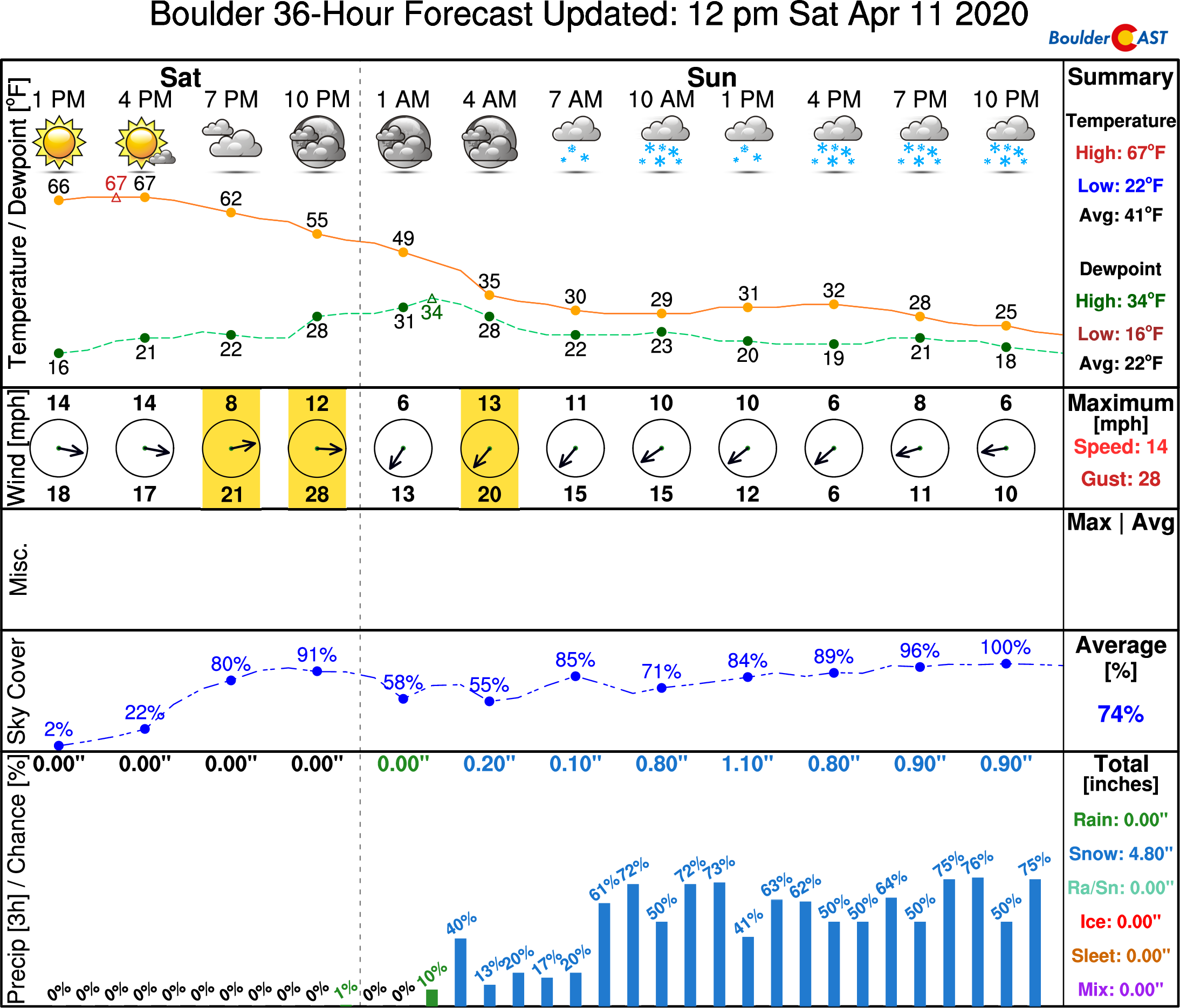
ince our last forecast update on Thursday, there have been a few changes with our incoming winter storm. Perhaps the most critical is that the system has slowed down considerably. While this may ultimately result in a longer-duration snow event for the area, it has shifted the timeframe for accumulation from the overnight hours Saturday night to instead be primarily during the day Sunday. If this were early January, a shift like this would have made little difference. However, we are getting late in the snow season and the spring sun grows more intense with every passing day. Now with the snow falling mainly during the daytime hours, impacts will be lessened with much lower chances for snow-covered roadways, more melting, and lower snow ratios. Let’s not get ahead of ourselves…the storm isn’t a bust yet! There’s plenty of springtime moisture to be wrung out across the Front Range in the coming days, most of which will be in the form of snow given the very cold airmass moving in!
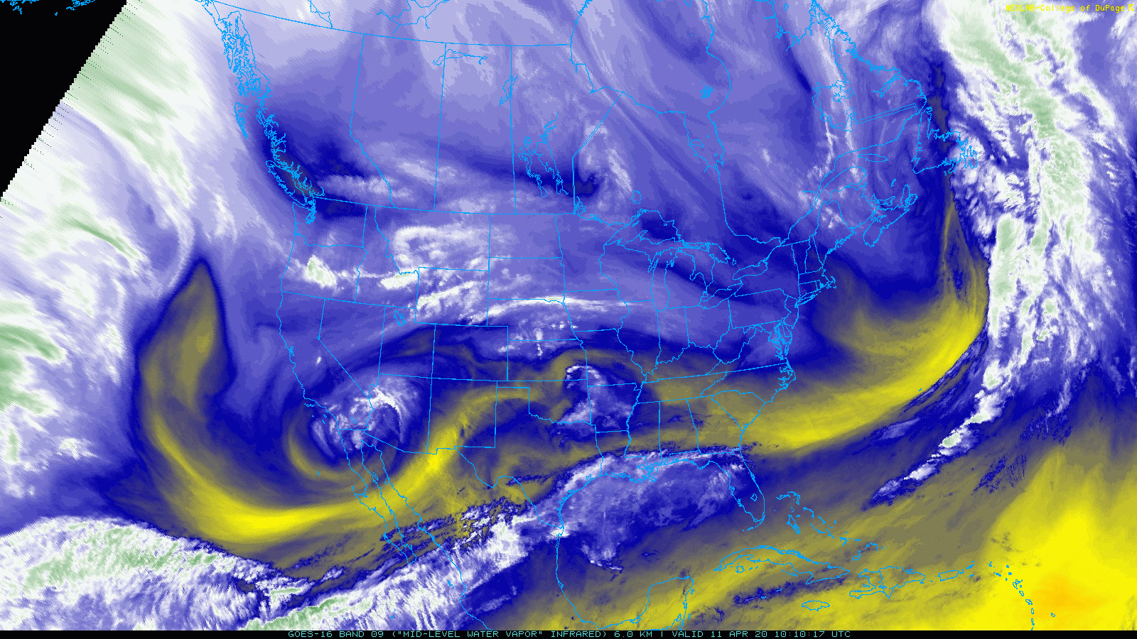
GOES-East water vapor animation from Saturday afternoon
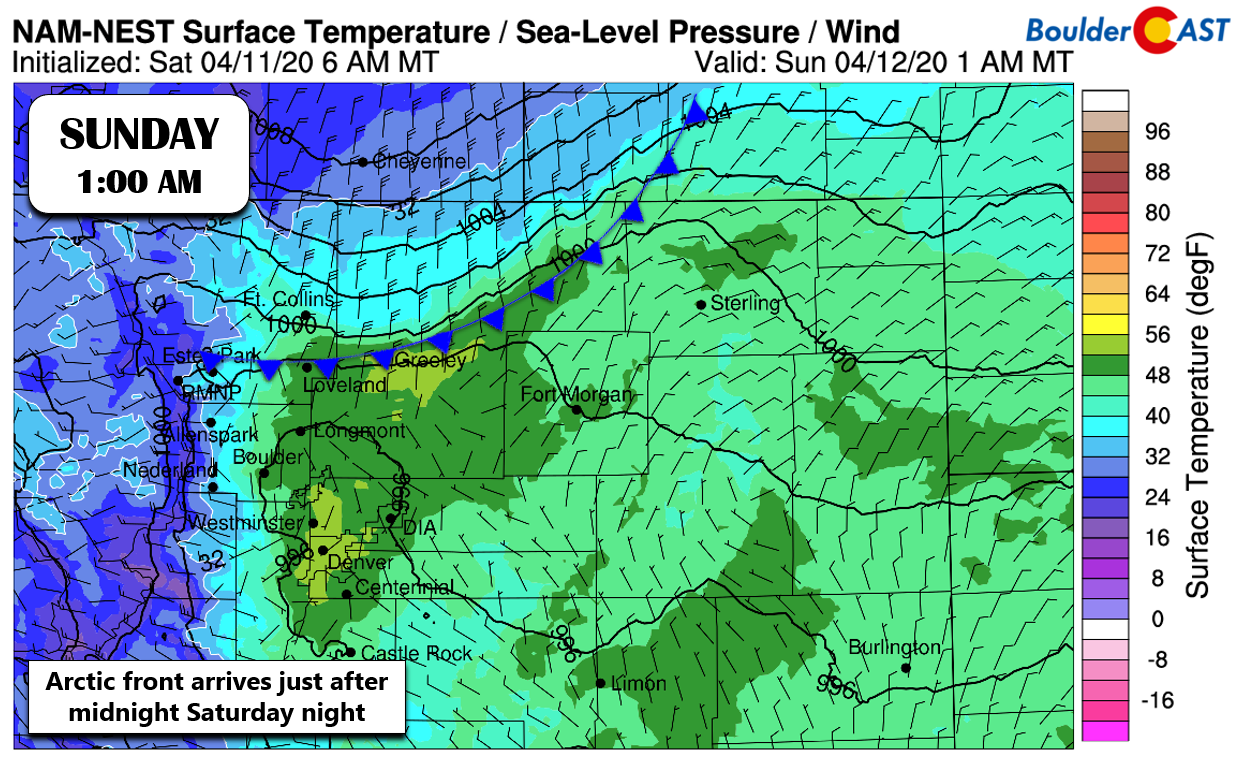
After a warm and sunny day Saturday, the transition to winter begins after midnight Saturday night as the leading edge of the Arctic cold front blasts southward into the Denver Metro area. Models are keen on showing the front pushing quickly through between 1:00 and 3:00 AM. However, a lot of convective activity is expected during the evening hours across southeast Wyoming and western Nebraska. Added outflow from thunderstorms and thundersnow to our north may help accelerate the front and push things through a little earlier. After the front, watch for gusty north winds up to 40 MPH and temperatures dropping sharply below freezing.
Around the time the front passes, we’ll start to see the first batches of showers develop which may begin briefly as rain across the lower elevations. With temperatures quickly falling and upslope setting it, any rain will quickly change to snow for everyone. The initial wave of snow in the several hours following the front will likely be the heaviest this system has to offer. A quick inch or three may fall by late Sunday morning in many areas.
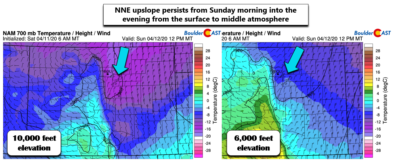
Things then turn towards a lighter, more upslope-focused snow event. Upslope will persist through the day Sunday into Sunday night (and maybe early Monday) which should keep light snow falling in and near the Foothills on-and-off. The upslope isn’t particularly intense and the direction from the north-northeast isn’t terribly efficient for us. As a result, the most widespread and persistent snowfall will be found in the far western and southwestern portions of the Denver Metro area and of course the Foothills.
As far as snowfall amounts, the forecast has many factors contributing to elevated uncertainty. This will be a long-duration snowfall event forced primarily by non-ideal upslope and large-scale (but weak) lift from the approaching trough. Models agree well that snow will be intermittent in Boulder and Denver from the wee-morning hours Sunday all the way into Monday evening. There will certainly be lulls in the action here and there, but more persistence in the snowfall will exist for upslope-favored areas in the far western Metro area, including Boulder.
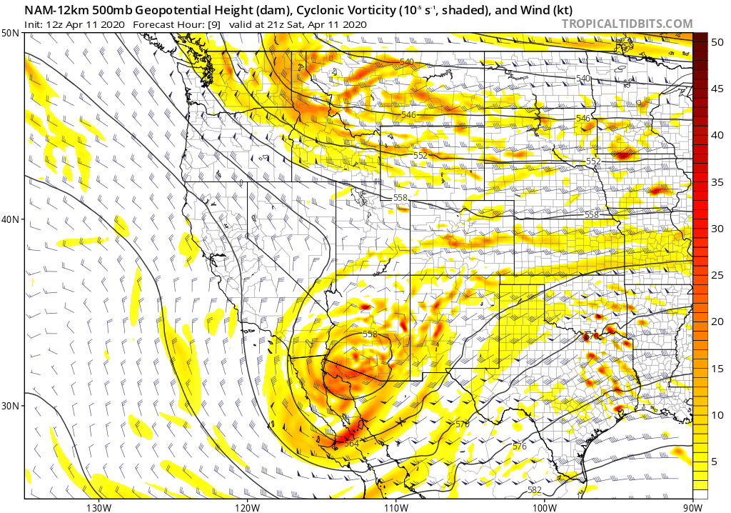
NAM 500mb vorticity forecast animation through Sunday night. Notice how the trough sinks into Colorado and then largely stalls
We also might have some added forcing from the overhead jet stream to deal with as the Front Range will rest almost perfectly in the left-exit region of a passing jet streak much of the day Sunday (see below). Models don’t really seem to care about this jet and generally refrain from developing any banded snow. Are the models under-estimating this? It’s hard to say. The jet itself is rather weak with top speeds only around 100 MPH. We still think there is a chance of seeing some jet-enhancement on Sunday, though banding may be fairly isolated. Furthermore, both Sunday and Monday will have weakly unstable conditions across the higher elevations during the afternoon and evening hours. This will further help to enhance snowfall across the Mountains and Foothills near and east of the Divide, with some pockets of more moderate snow likely to push out across the adjacent Plains as well.

With the strong April sun counteracting accumulation through the day Sunday on the Plains, many areas may appear to be coming in short on snow by evening. However, don’t let your guard down. Light snow will continue to fall Sunday evening and night with additional accumulations likely under the cover of darkness where it will stick much better.
Our snowfall forecast map for the event is shown below. We strongly remind you that this covers snow falling all the way through Monday morning and that there will certainly be lulls in the action and lots of melting during the day Sunday.

Temperatures may very well be the bigger story with this system in your location, especially east of Interstate 25. Daytime highs on Easter Sunday will stay in the 20’s, followed by 30’s on Monday. Overnight lows will be in the teens both Monday morning and Tuesday morning. For reference, the all-time record lows on both days in Boulder are 14°F. These definitely could be challenged, but may be too cold to reach with cloud cover stubbornly lingering during this time.
After this snow event, the weather pattern will remain very unsettled through much of the upcoming week with unseasonably cold temperatures lingering and more chances for light snow nearly every single day. Hooray!
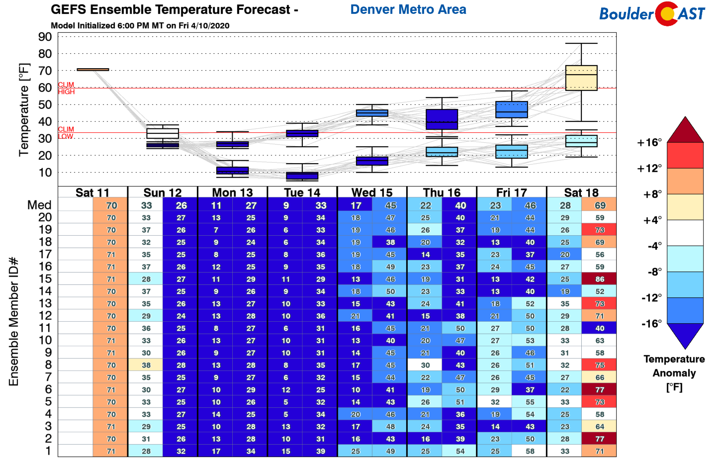
Cold temperatures stick around for much of the upcoming week
From all of us at BoulderCAST, stay healthy and have a Happy Easter (or plain Jane Sunday if Easter isn’t your thing)!
Spread the word, share the BoulderCAST snow forecast!
.
Subscribe to receive email notifications for BoulderCAST updates:
We respect your privacy. You can unsubscribe at any time.
.


You must be logged in to post a comment.