This winter has slowly become the “Winter of Freezing Drizzle” for the Front Range. Many of you have reached out to us wondering why there has been so many occurrences this year in particular. In short, the finger can be pointed at La Niña. However, the true answer is a little more complex.
We explained in a lengthy blog post before how rare freezing rain and drizzle is supposed to be for the Front Range, mainly due to our close downwind proximity to the towering Rocky Mountains and high altitude in general. Mother Nature sure has made a liar out of us this winter!
So far through the middle of February, Denver International Airport has reported freezing drizzle on 9 different calendar days (7 times in the first six weeks of 2018 alone!). To put things in perspective, the total number of days with freezing drizzle in the prior five years was only 12 (2012-2017). A “typical” winter has between one and three storms with at least some freezing drizzle.
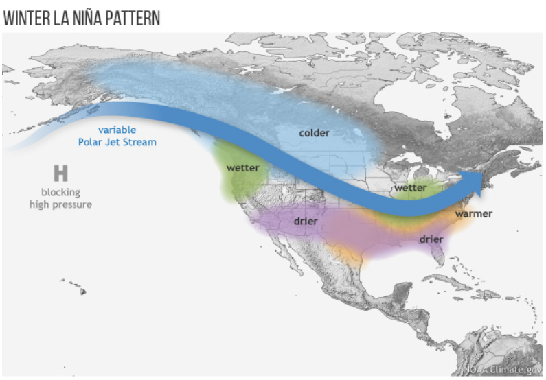
So what’s happening this winter to cause such a significant spike in freezing drizzle? The main reason is the type of weather pattern that has persisted for the last few months across North America….one that happens to be the poster child of La Niña. This pattern is shown in the diagram below. The key points are:
- A blocking high pressure across the northeastern Pacific Ocean. This controls the flow into North America and leads to….
- A more amplified and active polar jet stream that can dive further south into the United States. This leads to….
- More frequent cold air outbreaks across the northern Plains, which at times, can push far enough southwest to include Colorado.
Here is a look at 250 mb winds from our most recent freezing drizzle event last Friday/Saturday. The polar jet last weekend was a mirror image of the stdiagram above.
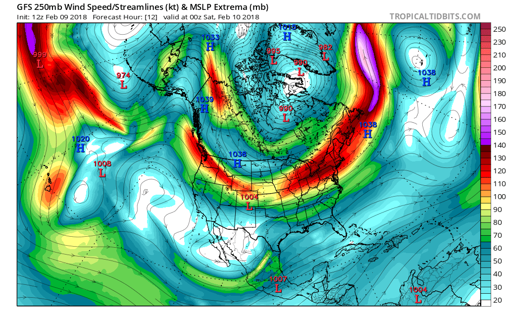
GFS modeled 250 mb winds for last Friday evening during a freezing drizzle event. The pattern matches up nicely with the generic La Niña diagram.
This weather pattern has been relatively frequent this winter, especially following the New Year. The maps below show the departure from normal temperature (left) and precipitation (right) over the last 60 days for the United States. Look closely and you will find a lot of similarities with the “WINTER LA NINA PATTERN” diagram above. Most importantly for our freezing drizzle, the extensive cold anomaly across the northern Plains. In many respects, this winter has been a “cookie-cutter” La Niña.
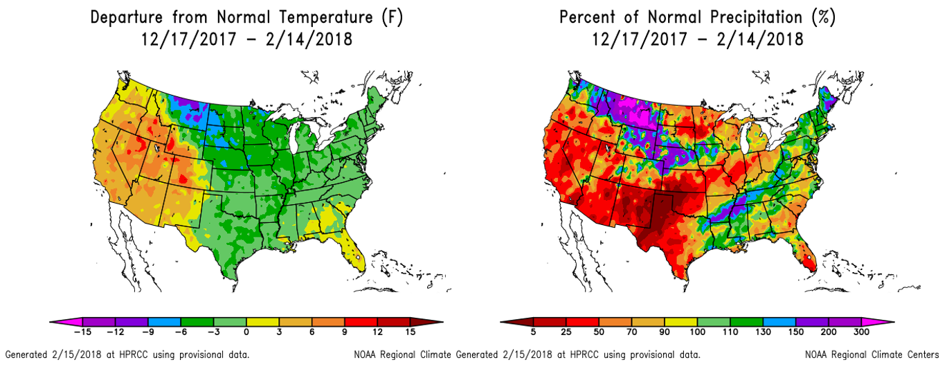
Departure from normal temperature (left) and precipitation (right) over the last 60 days.
FUN FACT: Some of our most historic cold air outbreaks have occurred during La Niña winters under this general flow pattern. Boulder’s last major cold air outbreak was in February 2011 when morning temperatures bottomed out at -17°F on Groundhog Day (our last moderate La Niña winter, BTW).
Frigid air from the Arctic and even Siberia can follow the amplified jet southward if things align just right. Such Arctic air masses are often very shallow, especially on the fringes, which is where the Front Range will more-often-than-not end-up. When this occurs, cold dense air rushes like water into the Metro area from the northeast. Sometimes it is even so shallow and dense it cannot make it over the Palmer Divide or the first wave of Foothills west of Boulder (like Mt. Sanitas). Something similar happened during last weekend’s freezing fog/drizzle event. The animation below shows a high-resolution temperature forecast from last Friday during the day. The model predicted a glorious battle between the shallow Arctic front and warmer air pushing in from the higher elevations!
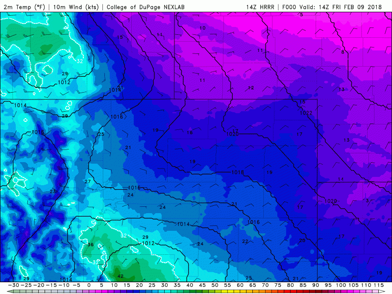
An HRRR model forecast for surface temperature during the day on February 9, 2018 across the Denver Metro area. On the edge of an Arctic airmass, temperature fluctuations can be extraordinary.
While the changes were not nearly as dramatic as the model projected for Boulder and Denver (yeah, models are bad with shallow cold air), some locations in the lower Foothills experienced dramatic temperature fluctuations as the frontal boundary “wiggled” back-and-forth. A temperature graph from one such location near 7,000 feet elevation in Boulder County is shown below. Without any context, one may suspect the temperature sensor to be broken. Alas, it was not!
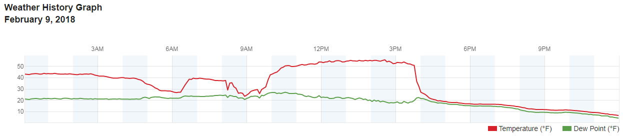
Temperature and dewpoint graph for 02/09/2018 for a location in the Foothills west of Boulder.
While the presence of Arctic air is a key component to freezing drizzle, it isn’t the only one. The skew-T diagram below shows the set-up from last weekend, one which checks many of the boxes for freezing drizzle to occur.
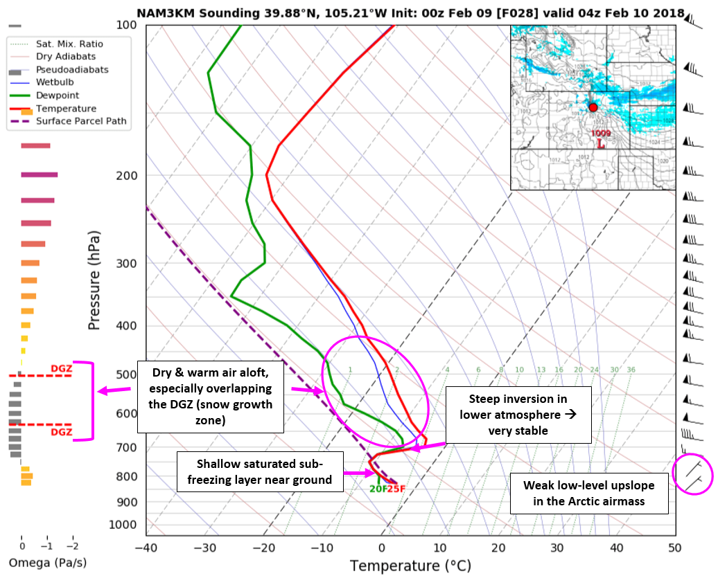
A skew-T diagram from late Friday night (02/09/2018) where freezing drizzle was falling across the Metro area. We have annotated several key factors.
A second key ingredient is warmer and drier air aloft to increase low-level stability. This stable layer decouples the near-surface fog layer, allowing super-cooled drizzle to form as upslope slowly brings in more and more moisture. This decoupling is something that generally only happens when, ironically, not much weather is happening across Colorado! Essentially, the Arctic front must overlap with a period of tranquility aloft. Due to the recurring weather pattern mentioned earlier, this has happened on numerous occasions this winter. Sometimes the calm conditions aloft have lasted the entire event, while others times for only a few brief hours before precipitation transitioned to snow. Either way, the net result was freezing drizzle for the lower elevations…
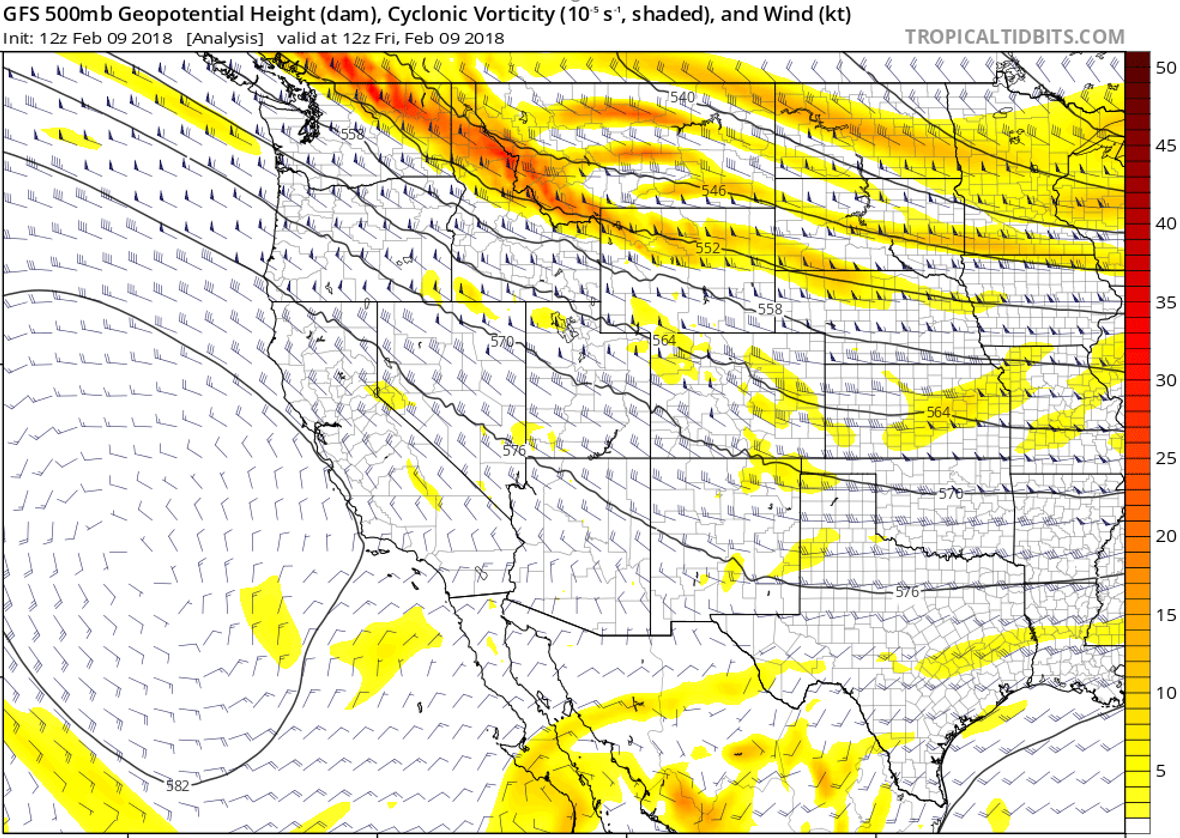
GFS 500 mb vorticity forecastsduring the event last weekend. At this time, widespread freezing fog and some drizzle was occurring across the Metro Area. Note the lack of vorticity or any waves over Colorado at 500 mb (the middle atmosphere).
So yes, we can blame La Niña for the icy roadways and slick sidewalks this winter! She has spawned the general weather pattern capable of simultaneously providing both shallow Arctic air and drier/calm conditions in the middle-atmosphere to Colorado.
How many more freezing drizzle events will we see this winter? La Niña is weakening quickly, freezing drizzle climatologically becomes even less frequent during the spring months, and the outlook for the next 90 days is DRY one. We’d like to think it’ll be all snow from here on out, but it’s been that kind of year. It seems like it barely snowed at all this winter, despite Boulder is only running 8 inches below normal (38″ of snow vs. normal of 46″ through mid February). We’re now heading into the snowiest time of the year! So at least we have that going for us….
Subscribe to our posts to stay in the loop. Whether it be snow or freezing drizzle, we’ve got you covered!
Subscribe to receive email notifications for BoulderCAST updates:
.
Share this post:
.


You must be logged in to post a comment.