As April comes to a close, we are now fully entrenched in the Spring season here in the Front Range. We take a look at trends, climatology, and predictions for the next month in Boulder.
Spring is an interesting time east of the Rockies. A combination of favorable storm tracks, cool Canadian air, and Gulf of Mexico moisture makes the weather in March, April, and May somewhat of a grab bag. In springtime, the winter storm track is still over the region and moisture becomes widespread enough to produce semi-frequent, significant precipitation in Boulder. This combination makes this the wettest time of the year. In fact, May is Boulder’s wettest month, just beating out April, registering 3.05″ on average. The window for measurable snow in Boulder slams shut very rapidly toward the latter half of April, but May snow is not uncommon. In fact, May snowfall has been recorded 13 out of the last 16 years, so don’t put those shovels away just yet! After being on pace to set a record for most snowfall in one season, March and April 2015 disappointed with below normal snow totals. Luckily for those of you jaded of the winter season, with warmer air slowly regaining its grasp on Colorado, the bulk of May precipitation generally falls as the liquid variety.
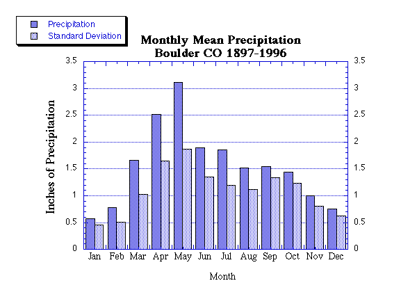
Monthly mean precipitation and standard deviations for Boulder. May is the wettest month of them all!
May also sees temperatures trending upward. The average high/low on May 1st is 65/39 degrees. By May 31st, it is 73/48 degrees. The hottest May day occurred on May 29, 2003 at 95 degrees, while the coldest temperature measured in May occurred on the 2nd in 2013 at 17 degrees. The takeaway: May in Boulder can feel like July……or January, depending on the mood of Mother Nature at the time.
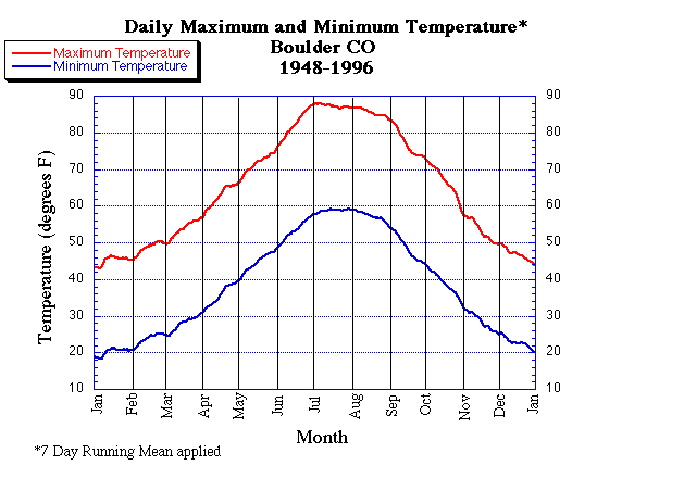
The annual cycle of mean high and low temperatures for Boulder
May also typically marks the official beginning of the growing season, as the mean and median date of the last frost occur in the first few days of May (see below).
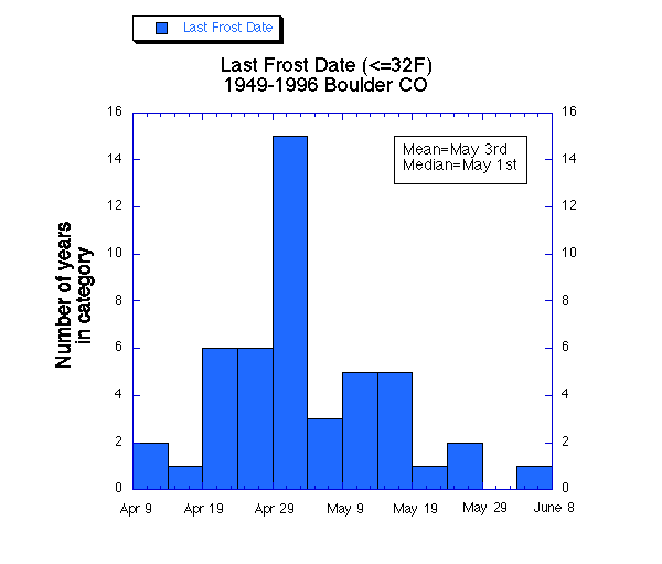
Occurrence of the last 32 degree temperature by date for Boulder. On average, the last frost is May 3rd. Unbelievably, the latest frost on record occurred on June 3rd. Fun fact: The latest measurable snowfall in Boulder occurred on June 5th, 2010.
In addition, May brings a profound jump in severe weather nationwide, including Colorado. However, Boulder County is protected from the bulk of severe weather due to it’s close proximity to the mountains. Therefore, we are mostly immune to this trend, with only 1 out of the 8 confirmed tornadoes in Boulder County since 1950 having occurred in the fifth month of the year.
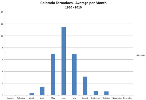
Average tornadoes observed by month in the entire state of Colorado. Data provided by NCDC.
So what should we expect this May? The NOAA Climate Prediction Center believes this May has an increased likelihood of above average precipitation, but has no insight into temperature trends. Check out the maps below. On the left, you can see that NE Colorado lies in the white EC region, which stands for “Equal Chance,” meaning that there is an equal chance of above normal, normal, or below normal temperatures (33/33/33). Essentially, this just says their models and proxies did not give any trend the probabilistic advantage in our region. However, from the map on the right, just about all of Colorado lies in the areas with at least 40% chance of above average precipitation in the month of May. What does this truly mean? Not much. Think about it. If there is a 40% chance of above normal precipitation, there is an even greater chance of not experiencing above normal precipitation (60%). Nevertheless, the media and public rave over these type of predictions, but try to take them with a grain of salt. Don’t reschedule your wedding or Memorial Day BBQ based on these forecasts!
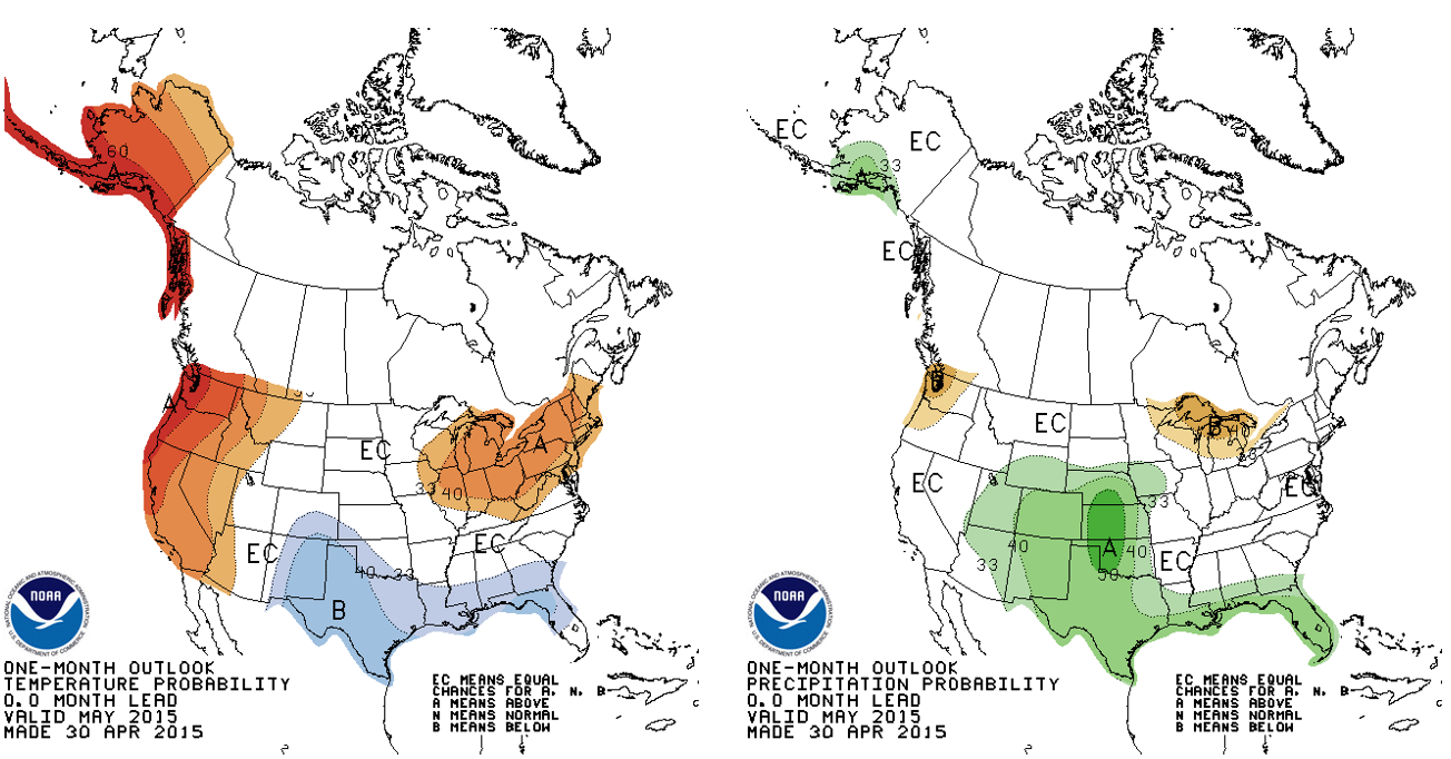
CPC temperature (left) and precipitation (right) outlook for May 2015, based on computer model output, correlations between various meteorological parameters, and various climate indices (like El Nino)
In summary:
May in Boulder can have you shoveling snow one day and turning on your car’s air conditioning the next. Historical climatology says May should be quite wet and to even expect a few snowflakes. This year, the Climate Prediction Center postulates that May will be even wetter than average, with no insight into temperature. Here is to hoping precipitation pans out! With our snow pack currently right in-line with normal levels, added precipitation will help to ensure we avoid another wildfire season like 2012 (at least in NE CO)! The precipitation map below confirms we are right on track to do just that, with parts of Boulder County recording nearly double their normal precipitation to date in 2015. There is also growing speculation that a moderate to strong El Niño will develop through the summer and into Winter 2016 (which is generally correlated with increased precip for the Front Range), but we digress. That is a topic for another post. Be sure to check back later!
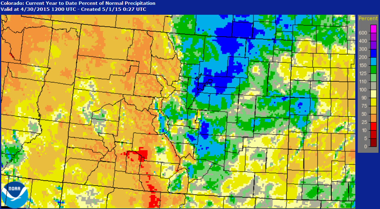
Year-to-date precipitation map for Colorado, shown as the percent of normal. While most of the Urban Corridor lies above average, SE Colorado and all areas west of the Divide are well below for the year.


