The latest computer models are indicating the storm could pack a bit more moisture that previously expected. Depending on your stance on snowfall, this could either be great or horrible news to you.
Overall, the storm system is coming together as expected, if not a tad bit earlier for the region. A very wet light to moderate snow is already falling over much of the Denver Metro area, with temperatures steady in the mid-30s. The ground is far too warm, and with the sun rising soon, don’t expect much accumulation in the city just yet (up to 1” in only the heaviest bands), as this will shortly turn to all rain on the Plains. The “big” tweak for the forecast may be amount of available moisture. The great thing about springtime snowstorms on the Front Range is their ability to, at least partially, tap into abundant Gulf of Mexico moisture. The problem is, to do so, they are also advecting in warm air at low levels along with the moisture. And more importantly for this storm, which relies heavily on dynamic cooling for areas below 6,000 feet, a moister air mass means less dynamic cooling. It is this tricky dilemma that determines who gets slammed with heavy wet snow, and who gets only a chilly rain. This increased moisture is exactly what appears to be happening in the latest model runs, but only marginally. With decreased dynamic cooling, the main impact on snow for now appears to be that the storm may follow the warm trends outlined in our previous forecast, which only affects lower elevations. For Boulder, 4-6” still seems likely, but just 1-4” possible in eastern Boulder County and the Denver Metro area. The cutoff for 100% snow may shift upward a few hundred feet in elevation, but overall the Foothills’ and Mountains’ forecast is still on track, unquestionably picking up 12-30”, with the possibility for 3 feet in favorable, east facing slopes. Most areas of Boulder County will pick up 1.5-3.0” of liquid equivalent. Don’t expect any major flooding as this is a very temporally drawn out system and most of this precip will be falling as snow above 6,000 feet.

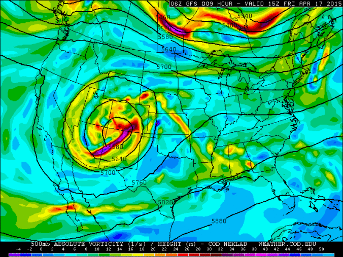
500mb heights and vorticity, valid at 11am MT Thursday
Remember, this storm system is the resultant of a cut-off upper level low pressure, meaning it has broken away from the westerly polar jet stream currently situated over southern Canada. Without this connection, there is very weak steering flow to push the system along. Models notoriously have a tough time deciding which direction and how quickly to move these systems. Stay tuned for further updates on this very fickle storm.


