This week we discuss warmer than normal temperatures through Wednesday, followed by slightly cooler weather to end the week. As something to look forward to, the upcoming weekend is shaping up to be rather pleasant!
DISCLAIMER: This weekly outlook forecast was created Monday morning and covers the entire upcoming week. Accuracy will decrease as the week progresses as this post is NOT updated. To receive daily updated forecasts from our team, subscribe to BoulderCAST Premium.

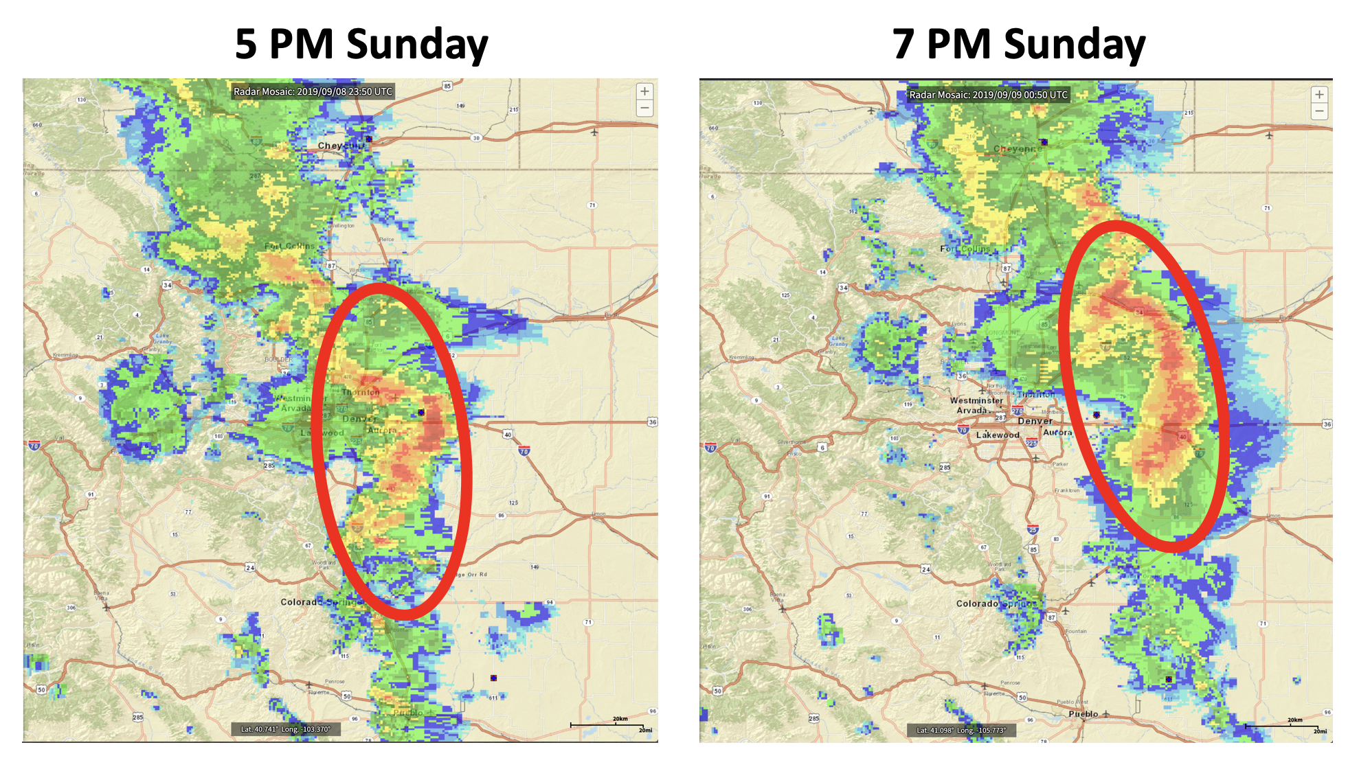
Last night’s storms were quite impressive. While not severe in Boulder, stronger storms existed in Denver and to the east. The radar image below from 5:00 PM last night shows that storms were moving through as expected during the late afternoon and early evening, with most of the activity pushing well to our east before sundown.
As disorganized thunderstorms rolled off the Foothills and tracked further north and east they strengthened into a bow echo (below right figure circled in red). A bow echo signature on radar is curved similar to an archer’s bow, hence the name, and is quite rare across the immediate Denver Metro area.
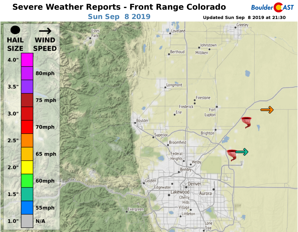
Usually this type of signature is associated with strong straight-line winds, heavy rain, and hail. Storm reports from Sunday evening included strong winds up to 70 mph and at least two tornado sightings near and northeast of DIA. Xcel energy reported tens of thousands of customers left without power in this area.
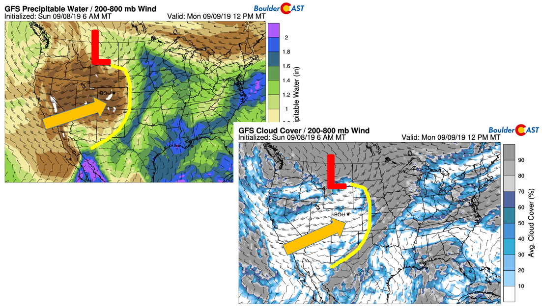
Following yesterday’s severe weather and frontal passage, the responsible system has moved well off to our east and north. Below shows the continental U.S. precipitable water (a measure of total atmospheric moisture; low values denote dry air) and cloud cover (bottom) for this afternoon. As is noticeable by the “L”, the system has moved up into central Montana. In its wake, there is a sharp demarcation between the moist and dry air. The yellow line shows this change in the airmass. Over Colorado, the air has become bone dry. Precipitable water values have dropped from Sunday’s values over 1 inch to only near 0.1 inches today! That’s some airmass change. As you may have guessed, that will spell out crystal clear sunny skies to start the week. Following morning fog, only a few clouds are expected on Monday given the dry air in-place (bottom figure). Highs today will be slightly above seasonal normals in the lower 80’s.
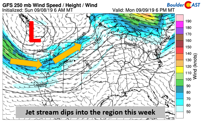
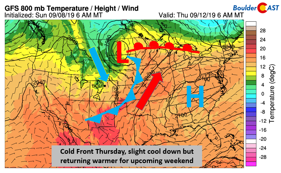
The upper-level jet stream will be dipping south into the western United States this week (below) and that will largely be the focus for the weather in the near-term. A deep trough in the Pacific Northwest will shift into the Dakotas by Thursday. Most of the lift and adverse weather conditions will stay north of our region, but it will eventually lead to another cold frontal passage later in the week for us.
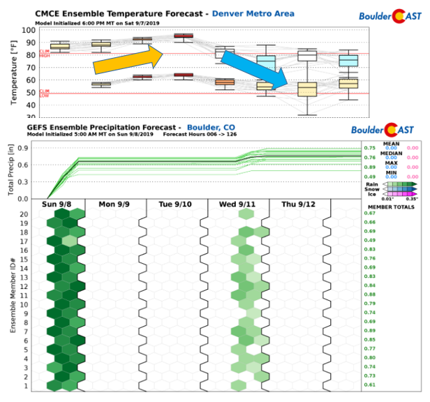
A similar but different way of looking at this is to examine the ensemble forecasts, a set of multiple forecasts created from the same model by “tweaking” the initial state just a tad to produce a series of potential scenarios. The Canadian ensemble temperature forecast is the upper figure below, while the GEFS ensemble is shown for precipitation chances in Boulder. You’ll notice a uptick in the temperatures through midweek in the Canadian ensemble, as noted by the arrows. Then a gradual cool down takes place Thursday and Friday, denoted by the blue arrow. This same downtrend is coincident with the frontal passage and an increase in precipitation chances Wednesday, as noted by the GEFS ensemble having multiple members showing green (rain) for Boulder. This is the over-arching outlook this week. More details found below.
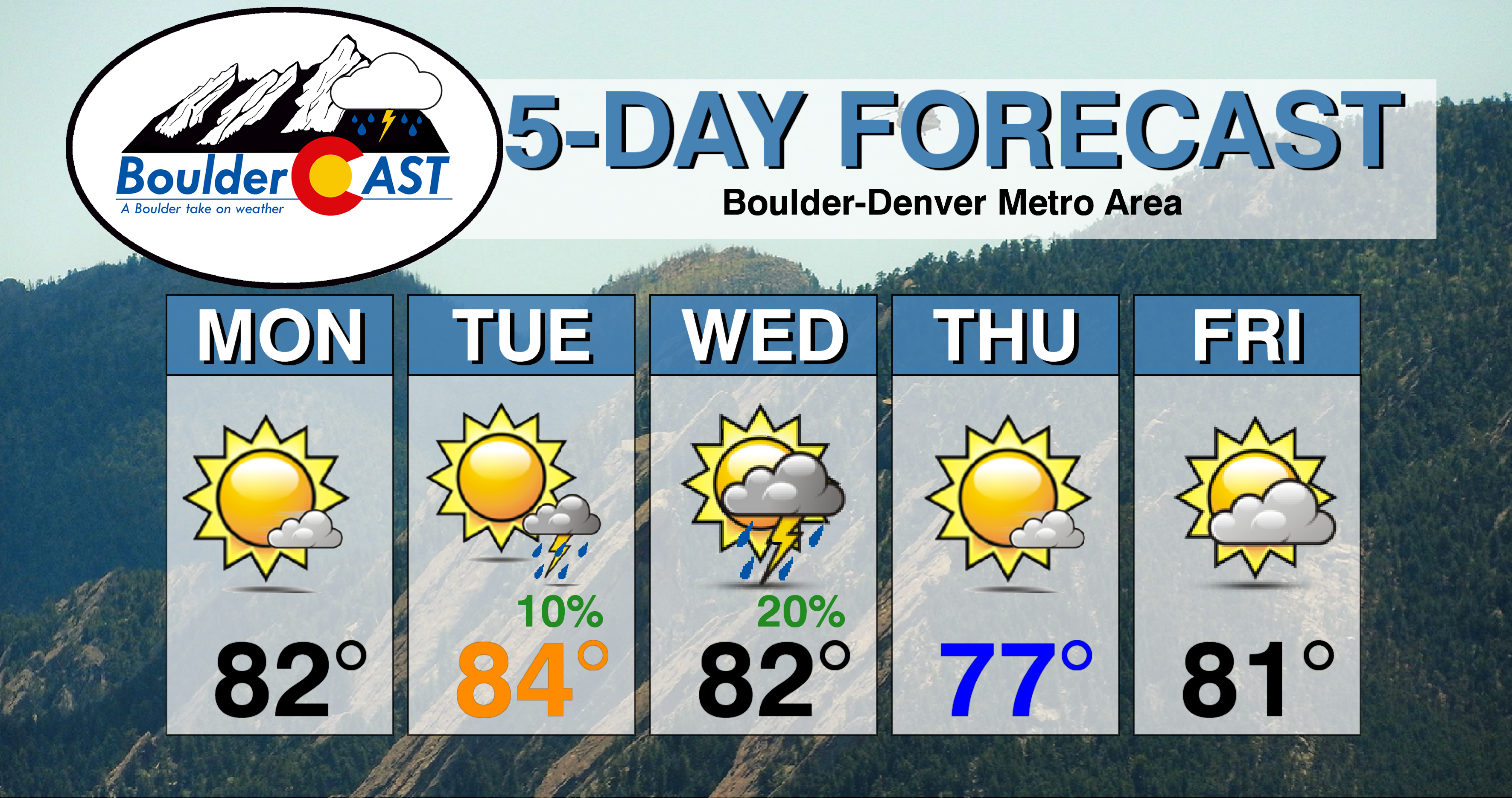
Warming tomorrow and Wednesday
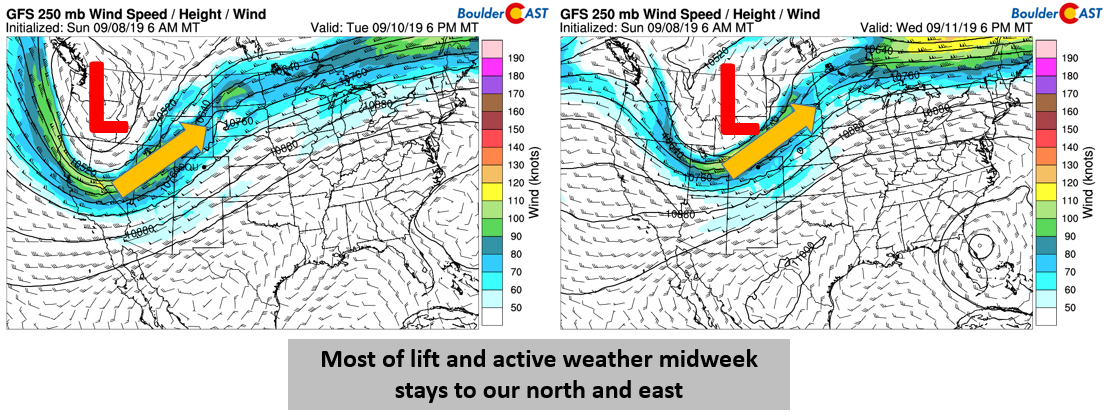
Tomorrow and Wednesday, the upper-level jet will remain to our west and northwest (below figures). Tomorrow the main jet axis will be across Utah, while on Wednesday it will move east-northeast into northern Colorado and Nebraska. The Front Range will largely remain in the southwest flow during this time. Lift for storms increases a tad on Tuesday but the main lift with the jet will be in Wyoming. On Wednesday, the jet is closer and so too is the lift, bolstered by an accompanying cold front. This will lead to our best chance of rain for the week. Nevertheless, the pattern is not overly favorable for storms, unless the trough dips further in the coming forecast model cycles. At this point, a 10% chance is warranted on Tuesday and 20% on Wednesday.
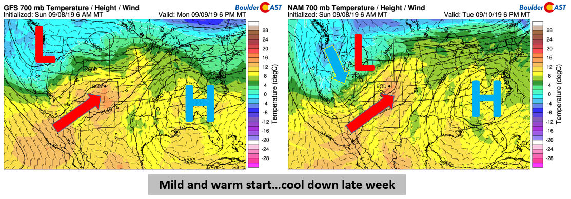
With southwest flow dominating tomorrow and Wednesday, the trend will see highs stay into the 80’s. The 700 mb temperatures (about ~5,000 feet above ground level; a good measure of the airmass over Colorado) tomorrow will rise to above average (below left). Much of the same can be said for Wednesday (below right) as high pressure remains anchored in the southeastern United States. Colder air is present though in Washington and Oregon, some below freezing, a sign of the front and the approaching autumn season!
 .
.
Cool down Thursday and warmer for upcoming weekend
As the cold front advances through late Wednesday night, more seasonal air should work its way back into the area on Thursday. The low pressure will have moved off into the Dakotas (below), with the front diving through Colorado and into New Mexico and Kansas. North and easterly upslope flow will thus return with highs in the middle to upper 70’s. The cool down is likely not to last long, as high pressure is slated to return rather quickly from the west, spelling out warmer temperatures for Friday and the weekend alongside mostly dry weather.
Forecast Specifics:
Monday: Patchy morning fog and low clouds, then mostly sunny skies and seasonal. Highs in the lower 80’s on the Plains and lower 70’s in the nearby Foothills.
Tuesday: Partly cloudy skies with a slight chance of isolated storms and highs in the middle 80’s for the Plains and middle 70’s in the Foothills.
Wednesday: Increasing clouds with a 20% chance of scattered thunderstorms. Highs in the low to middle 80’s on the Plains and upper 70’s in the Foothills.
Thursday: Mostly sunny and cooler. Highs in the middle 70’s to near 80 on the Plains and middle 60’s in the Foothills.
Friday: A mix of clouds and sunshine with highs near 80 for the Plains and lower 70’s for the Foothills.
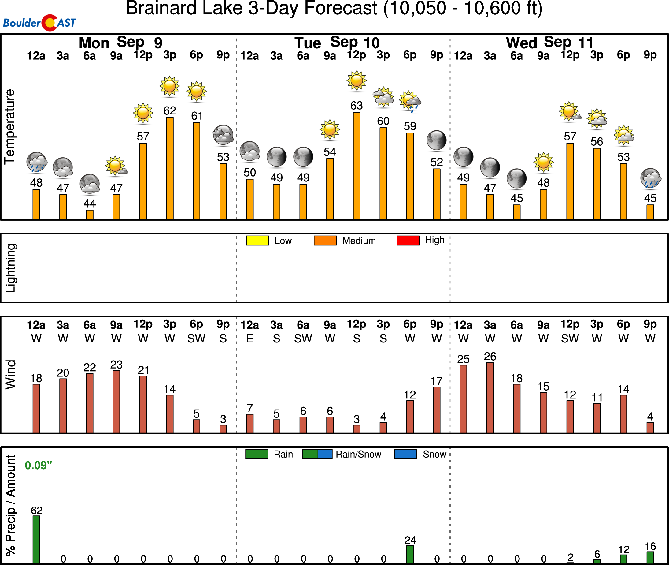
High Country: Mostly clear skies are expected over all mountain ranges on Monday. A 10 to 30% chance of storms will exist over the higher terrain Tuesday and Wednesday, along with gusty winds and more cloud cover. Drier and more calm weather is expected Thursday and Friday. Visit our SummitCAST page for updated forecasts for more than 120 Colorado mountain destinations, including all of our state’s majestic 14ers.
Spread the word, share our forecast!


You must be logged in to post a comment.