
Look for a relatively quiet last week of summer across the state with warm temperatures and dry weather being the main story. However, the forecast turns much different for the upcoming weekend. We’re also watching the Tropics for a few hurricanes that may impact the Eastern US. Read on for details.
Warm to start the week
Today’s 500 mb vorticity map is shown below. There are three important features to note:
- Hurricane Jose is still churning off the East Coast. We’ll discuss this storm later, but it has potential to impact the Greater Boston and New York areas.
- An unseasonably cool and deep trough of low pressure is rotating over the Pacific Northwest. This trough will be a player Tuesday night, and possibly again for the upcoming weekend with another chilly relapse across Colorado.
- Westerly downslope flow exists across our state today, and with the exception of Wednesday, it will be the dominant feature over Colorado this week. This will aid dry and unseasonably warm weather.
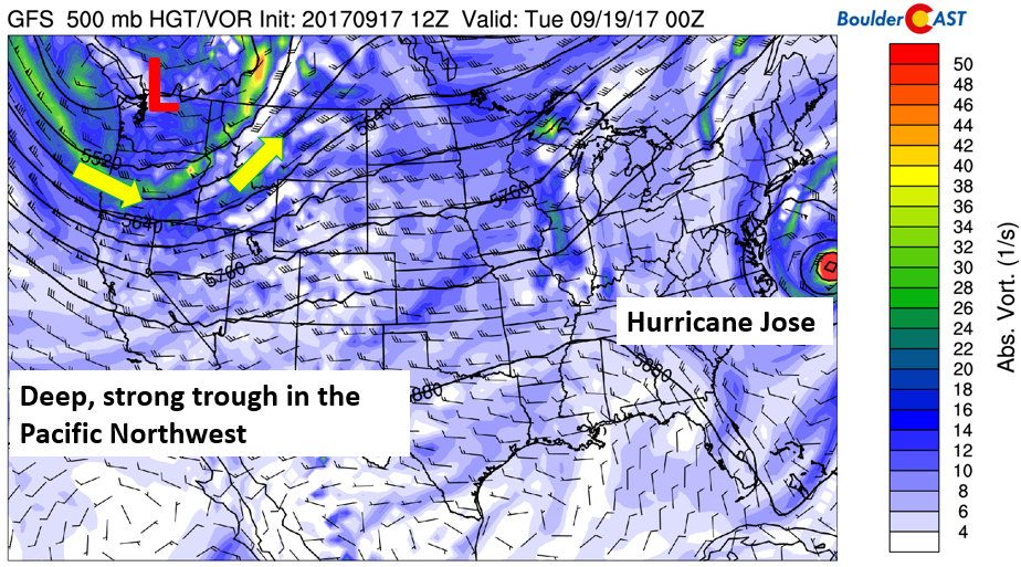
GFS 500 mb absolute vorticity map for today, along with today’s weather
Our Monday starts off about 10 degrees warmer than what we saw on Sunday. We’re expecting low 80’s over the area with lots of sunshine as downslope flow brings in warmer air from the southwest. Continued mild weather sticks with us on Tuesday as persistent westerly downslope flow remains. That will keep highs in the low to middle 80’s. Gusty west winds to 35mph in the Foothills will breed dangerous wildfire conditions Tuesday.
Cold front sweeps through Tuesday night
Overnight Tuesday night, a fast moving cold front will sweep through as the trough in the Pacific Northwest moves south and east and brushes the northern part of the state. That will bring in easterly upslope flow (below), and reduce temperatures back into the 70’s. Sunny skies should prevail once again with moisture rather limited.
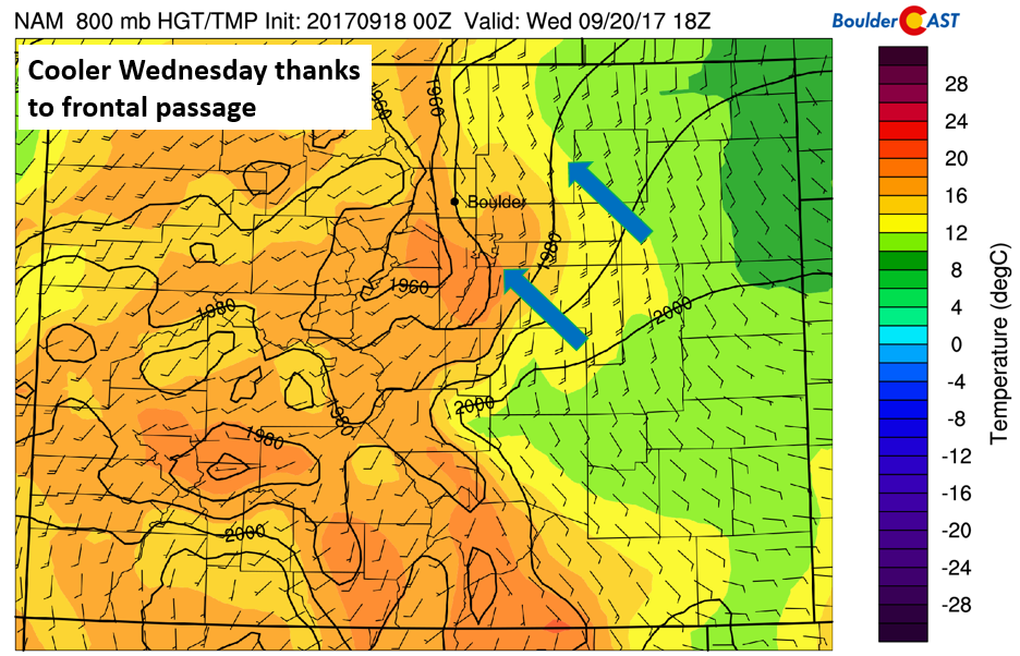
NAM near-surface temperature and wind for Wednesday afternoon
Watching Hurricane Jose and Maria
Two tropical systems are currently churning across the Atlantic, with a possible third behind Maria. Hurricane Jose, shown below, is forecasted to track northward over the next day or two. While the forecast calls for the storm to remain offshore, there is still a degree of uncertainty in its final track. It thus has potential to impact New Jersey, New York, and the Northeast, depending on which path it takes. The main impacts if any, would be wind, choppy waves, light storm surge, and some rainfall.
Maria is currently located northeast of South America. The track of this storm looks eerily similar to Irma. As expected, there is a wide range of potential solutions for Maria’s ultimate path; some reaching eastern Florida, some remaining offshore, some trekking up into the Carolinas and Northeast, and even a track going into the Gulf of Mexico. All eyes will be on this storm later this week. In the near-time though, islands of the Caribbean already devastated by Hurricane Irma two weeks ago will unfortunately be under fire from Maria over the next few days. The cyclone is expected to intensity into a Category 4 hurricane today or tomorrow.
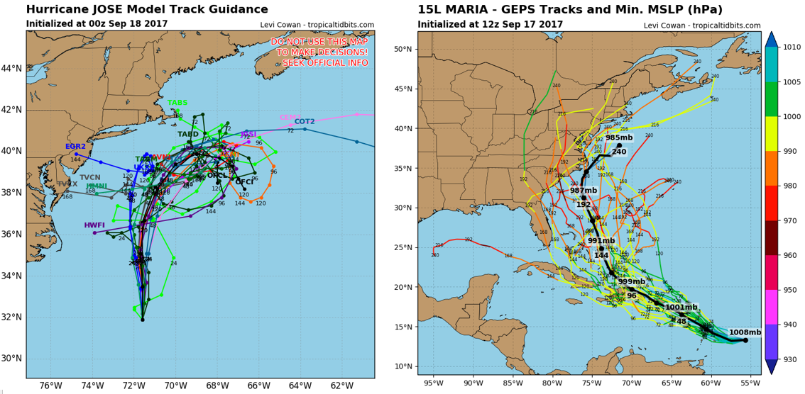
Hurricane Jose (left) and Maria (right) potential storm tracks
Thursday may be the warmest day across the region! Southwest flow returns which should push in the strongest downslope of the week. It’s possible that we could reach the middle 80’s in the afternoon. Meanwhile, the trough mentioned on Monday will continue to dig across California and Nevada.
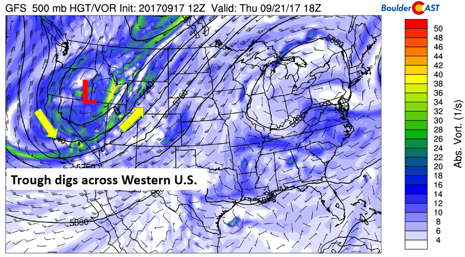
GFS 500 mb absolute vorticity for Thursday
First day of Autumn will be a transition…
On Friday (the first day of fall!), the pattern will continue to produce downslope flow. However, cloud cover with the approaching trough will be building in later in the day, lowering high temperatures to end the week, likely in the upper 70’s to 80 degrees. There is even a chance of a few isolated showers and storms across our region on Friday…the one day this week it COULD rain.
Below shows the upper-level jet stream pattern for Saturday. The trough finally makes its way eastward after staying to our west all week. In the upper-levels, southwest winds will be quite strong across Colorado with a surge of cold air coming down from Canada.
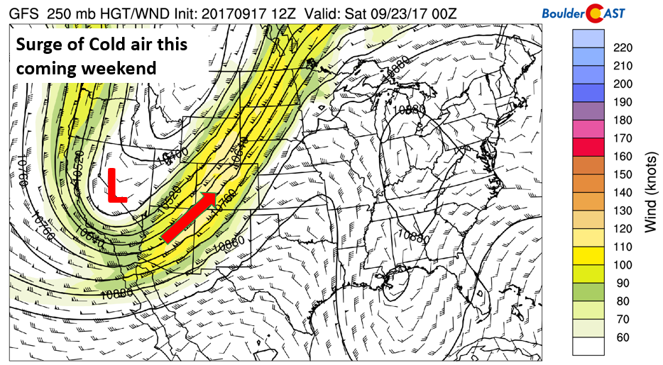
GFS 250 mb jet stream and height pattern Saturday morning
At the surface, the approaching trough will bring in upslope flow and northerly winds across northeastern Colorado. We’ll likely also see increased clouds, along with the chance of unsettled weather. It DOESN’T appear to be cold enough for our first snowfall on the Plains, but certainly looks cold enough for accumulation in the High Country! Lots of unknowns in the forecast of this trough, but indications are for a cooler weekend and potentially some precipitation, so stay tuned!
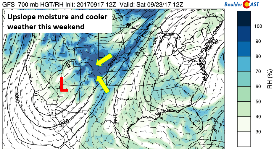
GFS 700 mb relative humidity and wind for Saturday
Forecast Specifics:
Monday: Sunny skies and warmer. Highs across the Plains will be in the lower 80’s with low 70’s in the Foothills.
Tuesday: A mix of clouds and sun, mild, and breezy with downslope winds of 10-20 mph. Conditions in the Foothills could approach Red Flag Warning criteria. Highs in the lower 80’s across the Plains, with mid 70’s in the Foothills.
Wednesday: Sunny and pleasant. Temperatures cooler in the upper 70’s on the Plains and in the upper 60’s in the Foothills.
Thursday: Mostly sunny and warmer with gusty southwest winds. Temperatures for the Plains in the low to middle 80’s on the Plains and middle 70’s in the Foothills.
Friday: Partly cloudy skies with increasing late day clouds. Isolated afternoon and evening thundershowers are possible. Highs a tad cooler in the upper 70’s to 80 for the Plains, with near 70 in the Foothills.
Weekend: Look for cooler temperatures as a large trough sweeps into Colorado Friday night. Highs will likely be in the 60’s or even 50’s on Saturday and Sunday, with more cloud cover and a chance of precipitation each day. At the time, it does not look to be cold enough for snowflakes across the Plains, but the higher Foothills might be.
High Country: Storm chances will be nil for much of the week, with the exception of Friday due to the approach of the trough. The main story will be strong winds each day from the west and southwest with gusts over 40 mph at times in the higher peaks. If you are hiking those 14ers, be sure to dress warm and be prepared for windy conditions. On Friday and into the weekend, the chance of precipitation increases, with rain and snow likely. Find the best days to hit the mountains over at our SummitCAST page.
DISCLAIMER: This weekly outlook forecast is created late Sunday or Monday morning and covers the entire upcoming work-week. Accuracy will decrease as the week progresses as this post is NOT updated. To receive daily updated forecasts, subscribe to BoulderCAST Premium.

Share our forecast:
Mon
Tue
Wed
Thu
Fri


Temperature
82
83
78
84
79


Precip Chc (Plains)
0%
0%
0%
0%
10%(pm)


You must be logged in to post a comment.