
After a warm final day to the weekend, one which Boulder set a record high at 92 degrees, this week is slated to turn much cooler starting this afternoon. Temperatures will be coolest on Tuesday with highs below seasonal norms and overnight lows falling Tuesday night likely into the lower 40’s on the Plains. This is all in response to a strong cold front pushing south from Wyoming. With the front also comes the chance of rain and storms but these look to be hit or miss through the week. Read on for the week’s forecast in its entirety!
Monday and Tuesday are cold behind the front!
Below shows the NAM model forecasted temperatures and winds just above the surface as of this morning. Outlined in blue is the cold front, showing north-northeast winds and cooler air behind the front. The red arrow depicts the movement of the front as today progresses. Of note is below freezing temperatures over Montana, something we will see more often as we go into late September and October with fall approaching! The front moves through this morning, but beforehand expect a quick warm-up into the 70’s over the Plains, then gradual cooling into the 60’s by late afternoon.
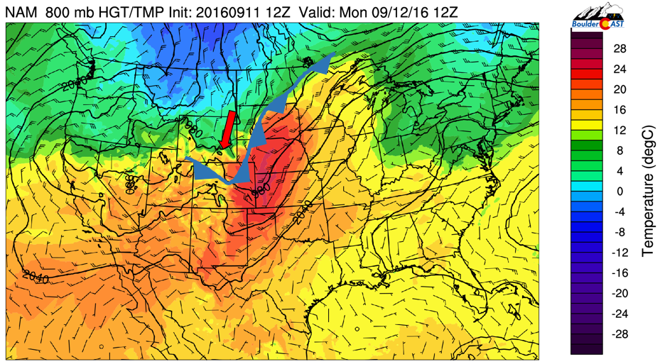
NAM 800 mb temperature and wind for this morning
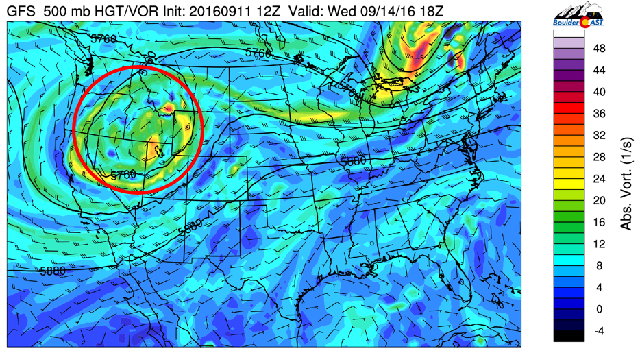
This cold front is all thanks to a large-scale upper-level trough digging southward into California and western Nevada today, as evidenced below (area circled in red). This trough will be a player throughout the week, sagging the cold air down from Montana and bringing with it waves of energy from the southwest that could trigger spotty rain/storms each day.
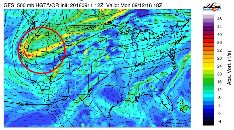
GFS 500 mb vorticity and height pattern for today
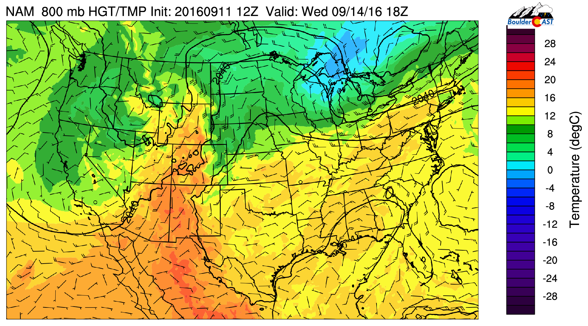
A zoom in of the cold front over Colorado as of this evening is shown below, with quite the temperature gradient! The front continues its southward push, banked up against the Foothills and Front Range. Moisture with the front will increase slightly with the frontal passage. This coupled with upslope flow will aid in spotty rain/storms early in the evening, primarily over the High Country and Foothills. Down on the Plains, our chances for rain will be slim as the cold air will prevent storms from maintaining their eastward movement.
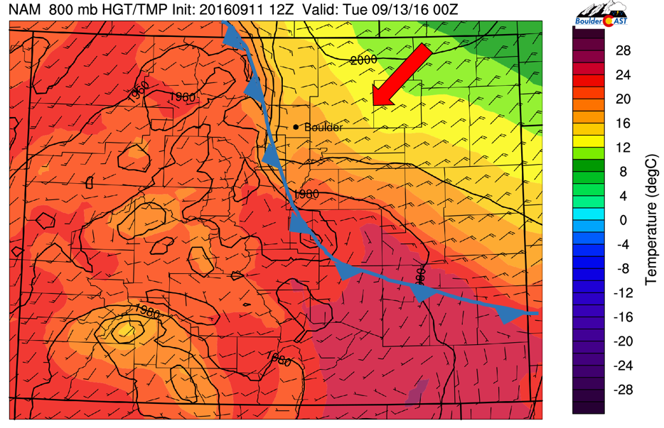
NAM 800 mb temperature and wind this evening over Colorado
However, despite the low precipitation chance this evening over the Plains, drizzle and cold air will be likely late evening and overnight with relative humidity rising to near 100%. This combined with lows in the 40’s will make for quite the autumn night. Below shows that humidity is above 90% over much of the Front Range Tuesday morning, which is indicative of lots of low-level clouds and fog. These clouds may linger into the early afternoon, slowly giving way to sunshine thereafter. As a result, with the cold airmass in place and clouds, temperatures will only rise to the middle 60’s over the Plains on Tuesday!
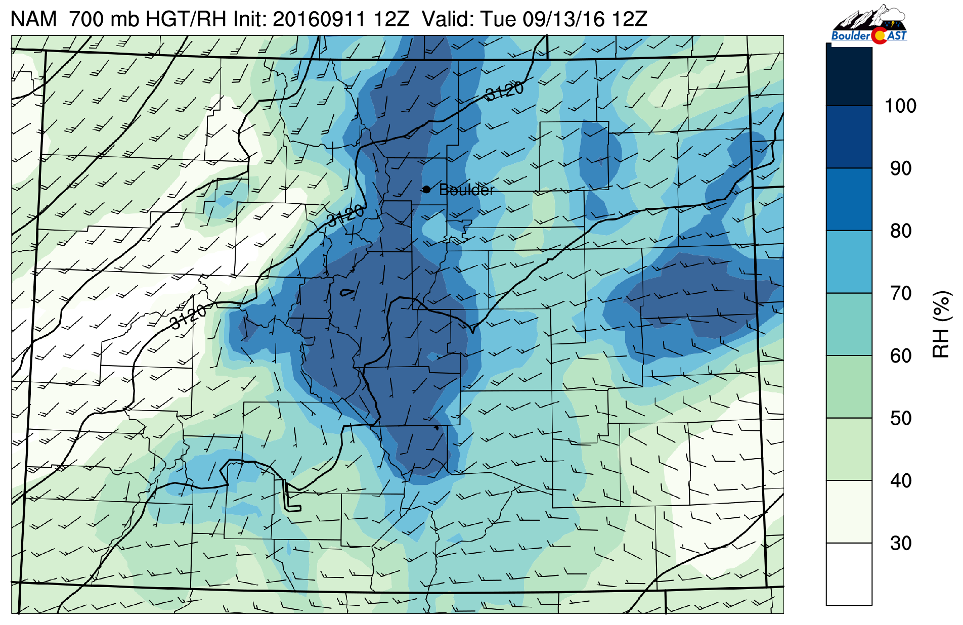
NAM 700 mb relative humidity and wind speeds for Tuesday morning
In terms of precipitation Tuesday, the chance will increase “slightly” for the Plains compared to Monday. However, the best chance looks to again be over the High Country and Foothills where daytime heating is stronger to support instability for storm development. Over the Plains, cloud cover will limit our warm-up and potentially cap (prevent) any storms from forming.
The models are quite different though, with the GFS very bullish on precipitation all week, especially Tuesday, while the NAM is quite weak. Below shows the total accumulated precipitation from Monday through Wednesday from the GFS and NAM. We believe the actual forecast lies somewhere in between the two models. Our best estimate is that the Plains will see spotty storms Tuesday evening but nothing widespread. Of course, if clouds clear out sooner, then storms could become more scattered.
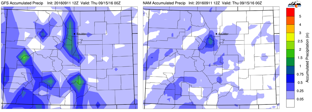
GFS (left) and NAM (right) accumulated precipitation through Wednesday
Wednesday still under influence of upper-trough
The upper splits from the main jet stream. This will lead to a cut-off low pressure system centered over northwestern Utah. Colorado will be under southwest flow in the mid-levels of the atmosphere, but more of a southerly-southeasterly direction in the low-levels.
GFS large-scale pattern for Wednesday
Below shows the low-level temperature and winds Wednesday afternoon. As mentioned, southeast-southerly flow will ensue, resulting in temperatures warmer than Tuesday, likely in the low to middle 70’s. Some clouds early will give way to afternoon sunshine. Wednesday looks like a good day of isolated storms over the Plains with more daytime heating. Moisture, however, will be lacking so don’t expect anything significant.
NAM 800 temperatures and winds for Wednesday
Much of the same will exist on Thursday with the upper-level cutoff low pressure system. It will be moving eastward over Colorado during the Thursday time frame. Downslope flow at the surface with aid in lots of sunshine and highs again in the low to middle 70’s. There is the potential of scattered storms, primarily over the Denver Metro and eastern Plains of Colorado Thursday afternoon/evening with the trough moving through.
Friday ends the week on a calm but cool note
The upper-level trough will weaken as it passes to our east into the Midwest, as indicated below. However, as it moves eastward, cooler air will again filter south into northeastern Colorado, compliments of northeasterly surface winds. Of course, this is too far out for an accurate prediction, but highs in the upper 60’s is certainly possible. Sunshine should be abundant though with little to no chance of precipitation with dry air in place. Overall, a great way to end the week!
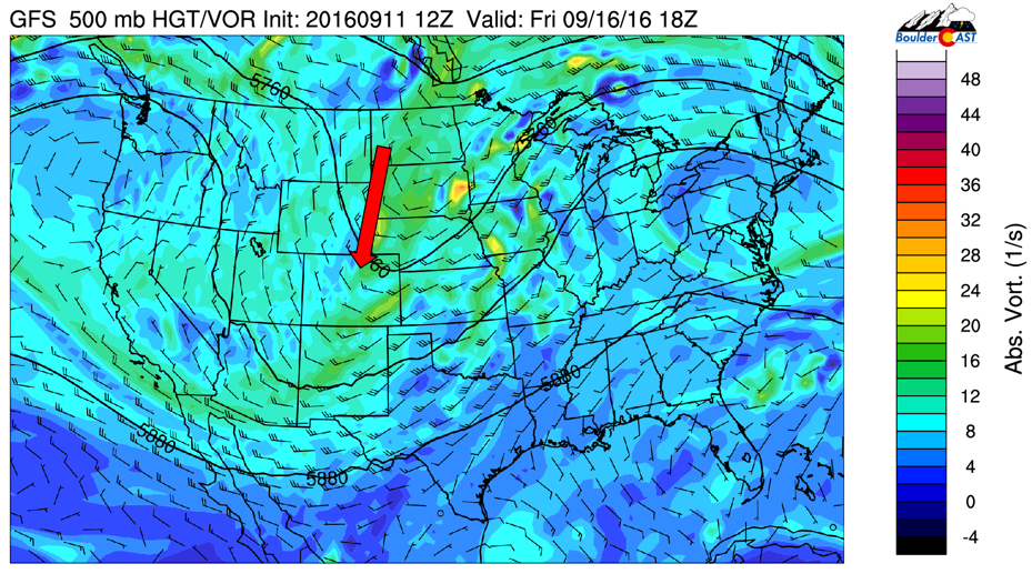
GFS 500 mb vorticity and height pattern for Friday
Just a reminder that our “First Snow” contest closes on September 16th. Be sure to get your entry in (see below).
Forecast Specifics:
Monday: Mostly sunny and mild with highs in the middle 70’s early over the Plains, with temperatures falling to the upper 60’s by early evening behind a cold front. Isolated storms over the High Country and Foothills with highs in the middle 60’s. Over the Plains, cloudy skies and drizzle will be possible in the late evening with temperatures falling into the middle 40’s overnight.
Tuesday: Mostly cloudy and cold in the morning, with patchy fog in spots. Clouds lingering into the early afternoon, with gradual clearing by late afternoon. Highs in the low to middle 60’s over the Plains and middle 50’s in the Foothills. Scattered storms over the High Country and Foothills, but only a spotty storm on the Plains.
Wednesday: Mostly cloudy in the morning becoming partly cloudy in the afternoon with isolated storms over the Foothills and Plains. Highs to be in the low to middle 70’s on the Plains and middle 60’s in the Foothills.
Thursday: Mostly sunny and seasonal with highs in the low to middle 70’s on the Plains with scattered afternoon storms, primarily over the Foothills and east of the Denver Metro. Over the Foothills, expect to see temperatures in the middle 60’s.
Friday: Mostly sunny and cool but pleasant with highs in the upper 60’s on the Plains and upper 50’s in the Foothills.
High Country: The chance of storms will be present over the High Country throughout the week. However, the best chance looks to be Monday through Thursday with the influence and approach of the low pressure system. Storms will be spotty throughout the week. A few widespread storms may be possible Wednesday and Thursday with the passage of the trough. Expect windy and cool weather over the higher terrain if you are hiking. In some of the more intense showers, snow will be possible with little to no accumulation, particularly Monday and Tuesday.
Extended: With the trough of low pressure moving east of Colorado Friday, a weak ridge of high pressure settles in for the upcoming weekend, spelling out warmer weather with eventual 80’s to return. It looks to be a great weekend to be out and about in the mountains. Remember, fall season in the High Country is approaching, so be sure to be on the look-out for the changing aspen trees as peak foliage is less than three weeks away!
Mon
Tue
Wed
Thu
Fri


Temperature
74
64
73
73
69


Precip Chc (Plains)
10%
10%
20%
20%
0%


