
A warm and fairly dry week is expected across the Front Range. However, we’re once again watching the tropics this weekend for another East Coast landfall and one storm which could impact Colorado. Read on for details.
Ridging thru midweek
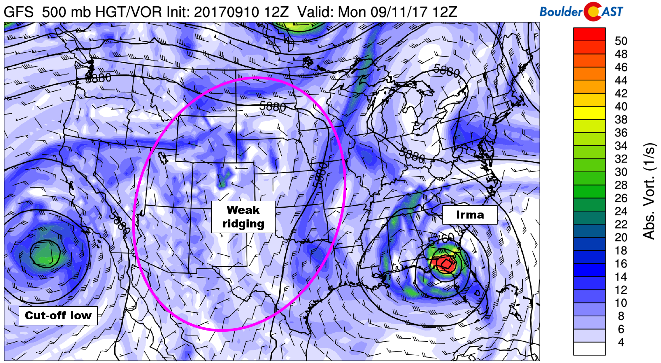
Today’s 500 mb vorticity map is shown below. There are three important features to note:
- Tropical Storm Irma is now over the Florida Panhandle and will continue to move northward into the Appalachian Mountains through midweek. This storm will have no impact on Colorado (hooray!)
- An unseasonably cool cut-off low is rotating off the coast of southern California. This system could be a player late in the week for our weather
- Between the prior two systems, not much is happening in the middle of the country. Ridging and weak flow aloft will contribute to rather tame weather through midweek in Colorado
After highs near 90 degrees both days this past weekend, a weak cold front moved through earlier this morning and as a result, highs today will be about 5 degrees cooler in the middle 80’s. Enough moisture remains around this afternoon for scattered afternoon storms across the Foothills, with at least a tiny chance of isolated storms on the Plains.
More stable air builds in at the surface from the north on Tuesday and Wednesday. We’ll expect more sunshine, little to no chances of rain, and slightly warmer temperatures these days.
Disturbance sweeps across Colorado Thursday & Friday?
Uncertainty remains in what will become the fate of the cut-off disturbance we mentioned earlier. It appears that the jet stream will grab a hold of it on Thursday. Models are then torn on whether it will move across Colorado Thursday evening as its own entity, or if it will get absorbed by the trough across the Pacific Northwest Friday morning.
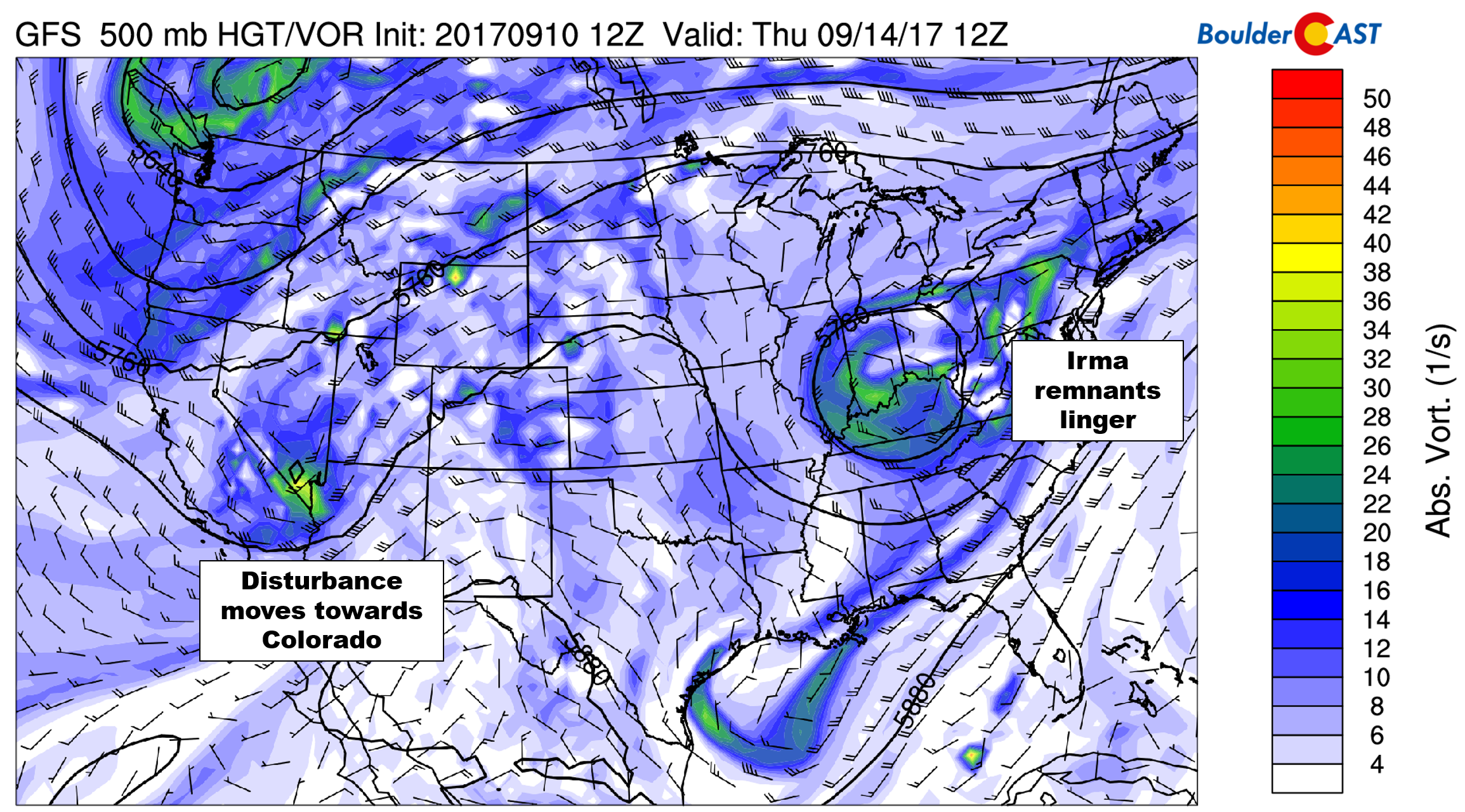
It’s hard to say which is more likely at this point. Nonetheless, either outcome will result in increases in moisture and rain chances for Colorado. However, a bulk of the energy will pass to our north and west. With this, we’ll expect marginally better odds for rain Thursday and Friday, with cooler air on the backside of the system Friday into the weekend. Highs will likely drop back down into the 70’s Friday through Sunday.
Watching the tropics early next week
Tropical sea-surface temperatures are more-or-less at their annual peak in the Northern Hemisphere right now (which is normal). Therefore it is not surprising that a few models are showing some interesting tropical activity on the horizon. The precipitable water anomaly animation below spans from this Thursday into Tuesday of next week.
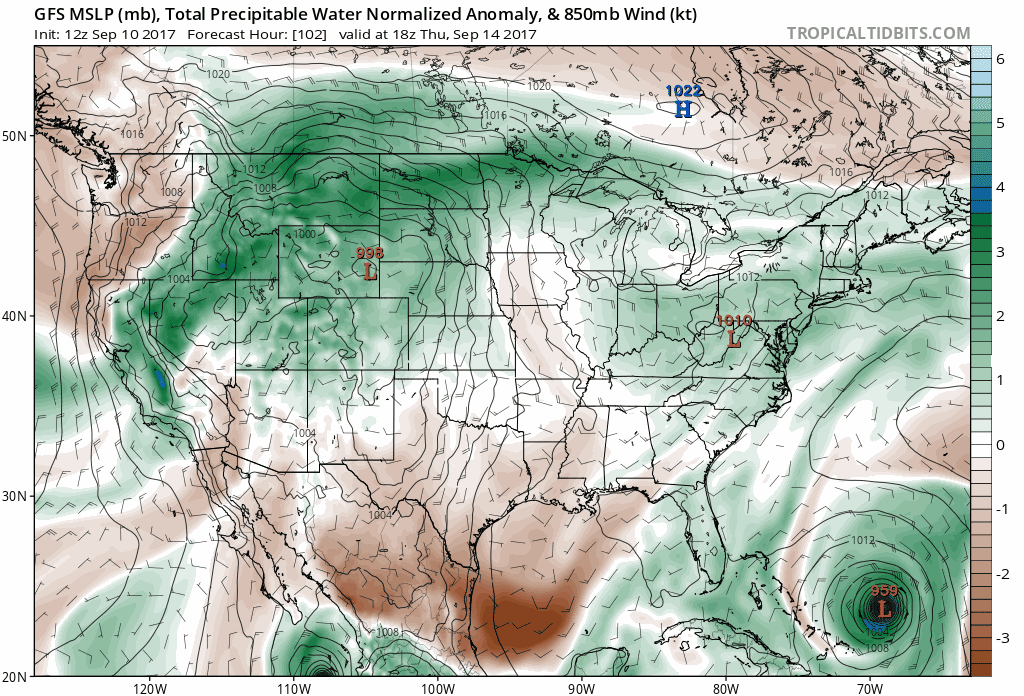
- The large tropical low riding up the East Coast is Hurricane Jose. Tropical meteorologists will have a tricky time with this one as it looks like we could be seeing yet another land-falling hurricane in the U.S this weekend or early next week.
- More relevant to Colorado, a tropical storm could be forming near the tip of the Baja Peninsula in Mexico this weekend. Right now the National Hurricane Center has 70% odds of this happening. The GFS shows moisture from this system pouring into Colorado Monday or Tuesday of next week. This would certainly bring rain to the state if this happens. The storm would be named Max if it does form. Right now, it’s not worth worrying about as uncertainty is high.
We leave you with a photo of the devastation caused by Category 5 Hurricane Irma in the Caribbean last week. Fortunately it was much weaker when it made landfall in the Florida Keys yesterday.

Fon’t forget! Our “First Snow” Contest closes on Friday. Enter at the link below:
Forecast Specifics:
Monday: Overcast skies in the morning compliments of the overnight cold front. Expect partly sunny conditions to take over by late morning. Scattered storms will form across the Foothills in the afternoon and evening, with isolated storms across the Denver Metro area. Highs across the Plains will be in the mid 80’s with low 70’s in the Foothills.
Tuesday: Partly cloudy in the morning, then mostly sunny. A few isolated storms may form across the higher elevations south of Denver, otherwise dry. Highs in the mid 80’s across the Plains, with mid 70’s in the Foothills.
Wednesday: Morning sun with increasing clouds during the day. Expect isolated afternoon and evening showers and a few storms, mainly across the Foothills. Temperatures will top out in the mid to upper 80’s on the Plains and in the mid 70’s in the Foothills.
Thursday: Mostly sunny in the morning followed by increasing clouds. Isolated to scattered thunderstorms will be possible in the early evening, especially across the higher elevations. Temperatures for the Plains in the mid 80’s with low 70’s in the Foothills.
Friday: Sunny and cooler with generally dry conditions prevailing across the state. Highs will likely be near 80 degrees for the Plains, with upper 60’s in the Foothills.
High Country: Storm chances will be 30-50% in the Mountains Monday and Thursday this week, with 10-20% chances the other days. Winds will be fairly light through Wednesday morning, with stronger winds Wednesday afternoon through Friday as the disturbance moves across Colorado. This means the best days for high elevation adventures looks to be Tuesday and Wednesday. Find the best days to hit the mountains over at our SummitCAST page.
DISCLAIMER: This weekly outlook forecast is created late Sunday or Monday morning and covers the entire upcoming work-week. Accuracy will decrease as the week progresses as this post is NOT updated. To receive daily updated forecasts, subscribe to BoulderCAST Premium.

Share our forecast:
Mon
Tue
Wed
Thu
Fri


Temperature
85
87
87
85
79


Precip Chc (Plains)
20%(pm)
0%
10%(pm)
20%(pm)
10%(pm)


