
The storm track has officially returned southward to Colorado! The first full-week of October will feature a swing in temperatures, starting off on the cold and wet side for your Monday. Meanwhile, the first dumping of snow in the Mountains and Foothills started yesterday and continues today. Read on for our complete outlook.
Season’s first snowfall in the High Country & Foothills
As early as Saturday evening, snowflakes started falling across the mountains of northern Colorado. The snow continued yesterday and will remain in place today before tapering off early Tuesday. Below shows two webcams from yesterday afternoon. One is located at the Alpine Visitor’s Center, while the other is a shot of Longs Peak. Winter has arrived in the mountains!
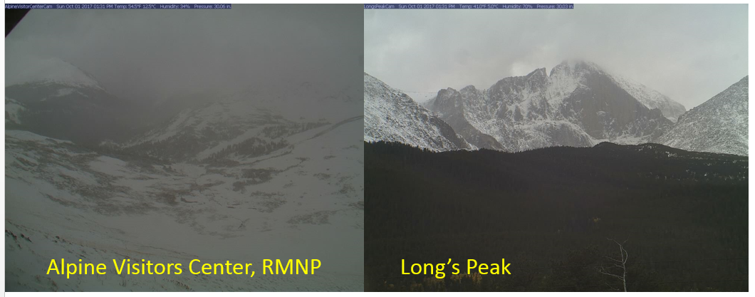
RMNP (left) and Longs Peak (right) on Sunday afternoon
You may have noticed the windy conditions Saturday night if you were driving. Much of what caused that and is responsible for the snowfall in the mountains today is a strong upper-level jet streak oriented southwest to northeast over Colorado. This is producing orographic lift in the High Country, and given the colder October air, is leading to snowfall.
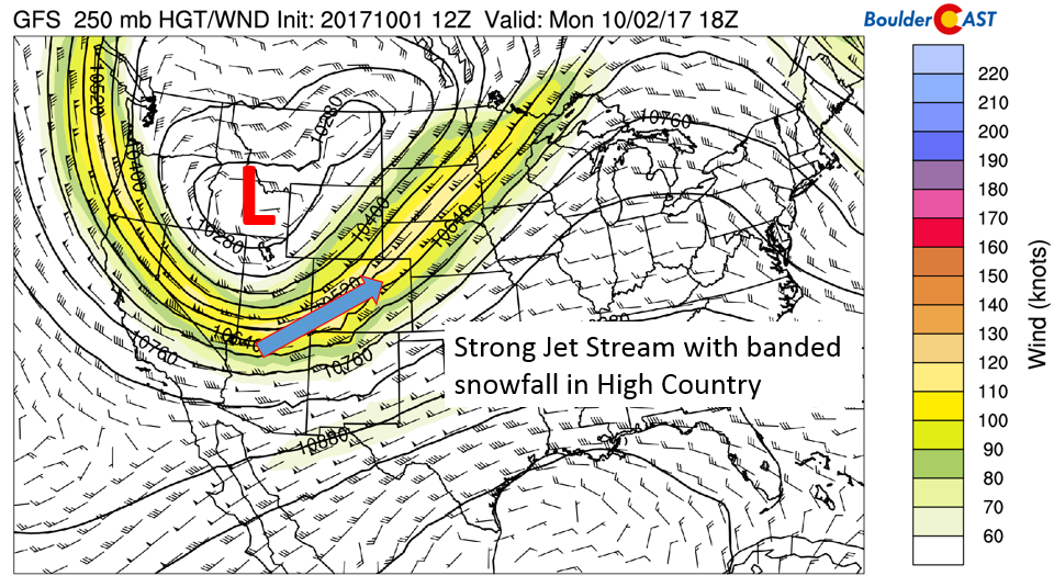
GFS 250 mb jet stream over the CONUS today
The presence of the jet streak is also producing banded precipitation across the state of Colorado. This is why the snowfall is so heavy in the Mountains, despite the general lack of large-scale forcing. The HRRR model output for Monday afternoon below shows these large bands of precipitation oriented parallel to the jet streak itself (southwest to northeast).
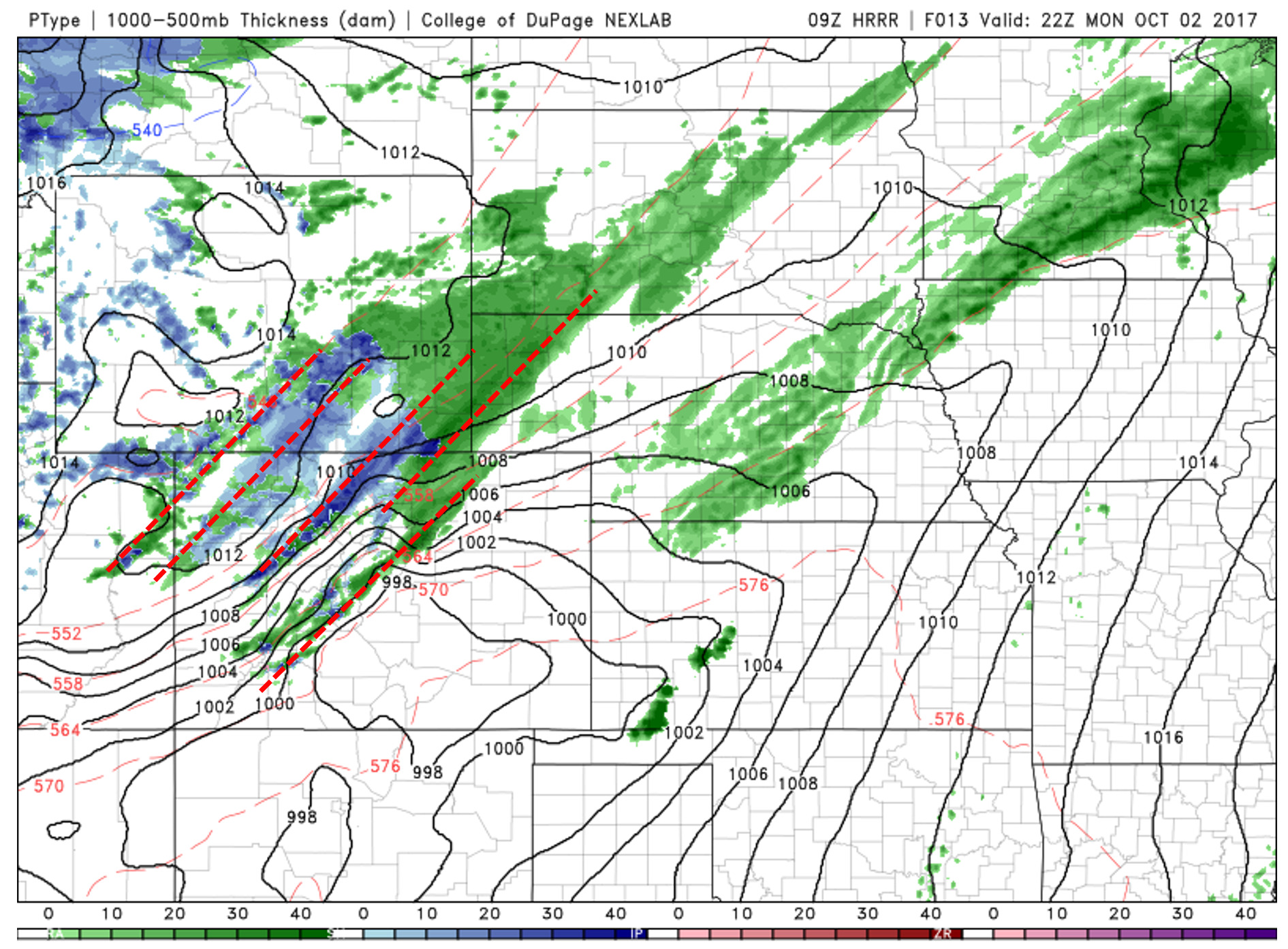
HRRR ptype forecast for Monday afternoon. Bands of precipitation are highlighted in red.
Total accumulations by Tuesday morning are shown below from the NAM forecast model……A wide swath of snow across Northwestern Colorado in the 5″ to 12″ range. Steamboat is certainly in the favored area, which should help to start a snow base there for the anxious skiers! The Foothills and Boulder and Larimer Counties will pick up their first significant snow as well. 3 to 8″ looks probable for locations above 7,500 feet. Of course, with jet dynamics in play, if you end up in one of these heavier bands for an extended period of time, some locations could exceed this range.
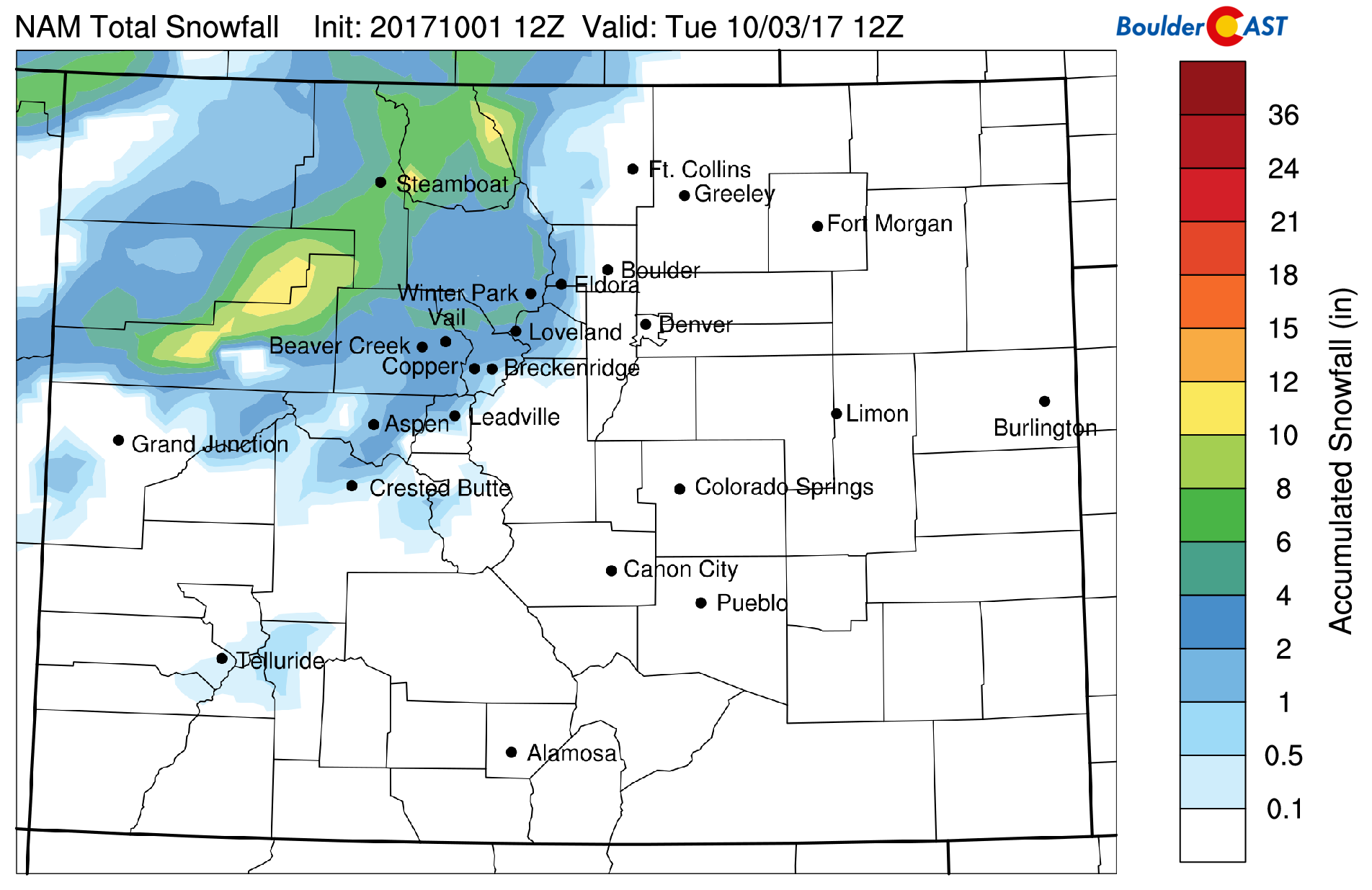
NAM model accumulated snowfall for Colorado ending Tuesday morning
In the mid-levels at 500 mb, an area of low pressure is situated across northwestern Nevada. To the south and east of this is a moist west-southwest flow stretching from Nevada, through Colorado, and into Nebraska. Embedded in this flow are shortwaves that will enhance lift along the jet stream and help to focus showers and even a few thundershowers this afternoon into the evening.
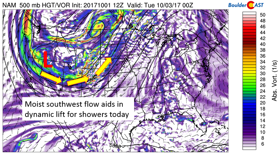
NAM 500 mb absolute vorticity for today
At the surface today, following the cold front which pushed through last night, chilly and moist upslope flow is in place from the east. Below shows that temperatures are in the 30’s about 1,000 feet above the surface. The upslope flow and lift dynamics discussed above increase the chance of unsettled weather today, along with a great deal of clouds. Look for high temperatures to stay only in the 40’s today…..a big change from where they were yesterday.
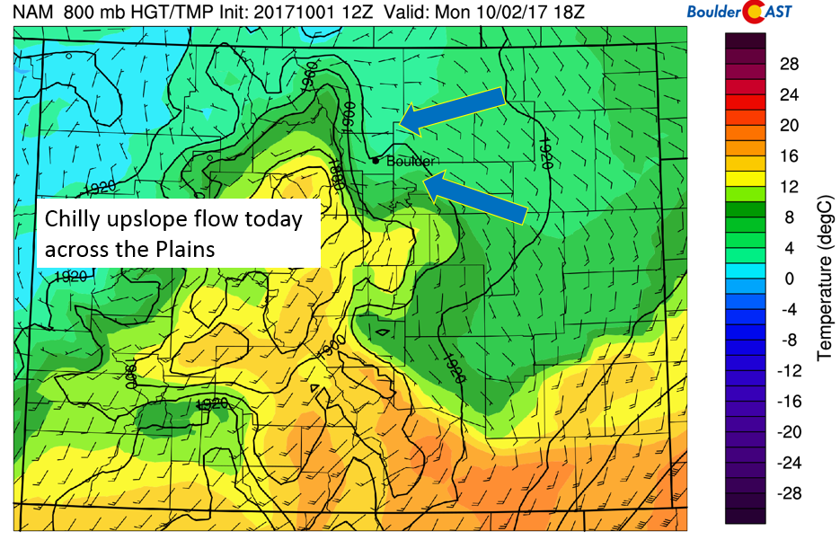
NAM near-surface temperature and wind today
As mentioned above, the jet streak is oriented southwest to northeast. That will lead to some banded precipitation across northeastern Colorado. While the chance of rain increases area-wide, the most favorable position will be along and north of I-70 and the Denver Metro, in the favored lift region of the jet where shortwaves are passing through. This is depicted quite well in the NAM (see below). Don’t be surprised if a few rumbles of thunder occur too. Showers will persist through the day Monday.

NAM forecasted precipitation this evening
If a heavier band or a thundershower moves across the lower elevations, it is conceivable a few flakes could reach the ground before melting across the Plains. We’re not expecting any accumulation, but isolated snowflakes today is a real possibility given the cold temperatures in the lower 40’s overlapping with jet-forcing.
Check out the snow in the Foothills on our LIVE WEBCAMS Page.
Cool upslope pattern persists through Wednesday
On Tuesday and Wednesday, the upslope pattern and chilly weather will likely stick around thanks to not much change in the overall pattern. The near-surface temperatures on Tuesday start out just above freezing in the Foothills (bottom left), and slowly warm up to the upper 40’s on Wednesday. This should keep us folks on the Plains on the cool side in the 50’s on Tuesday. Our average highs in the beginning of October are in the upper 60’s. Quite the disappointment when we are stuck in the 40’s and 50’s!
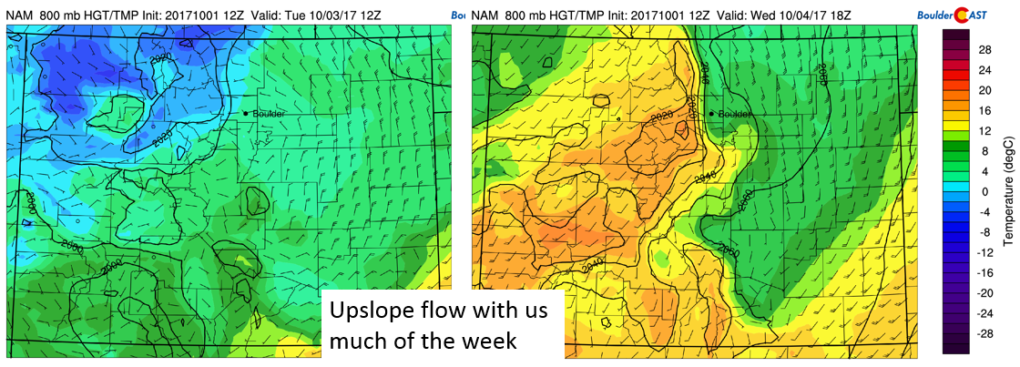
NAM model near surface temperatures for Tuesday and Wednesday
While some sunshine can be expected Tuesday, we think low-level stratus clouds will remain for much of the day as low to mid-level relative humidity remains high (see below). Wednesday the forecast models are hinting at more sunshine thanks to drying out of the airmass, which should help temperatures moderate somewhat. While there is a chance of light showers or drizzle Tuesday, most of us should stay dry on Wednesday.
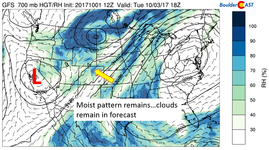
GFS model 700 mb relative humidity for Tuesday
Warming up by week’s end
The low pressure system that was over Nevada on Monday is predicted to move into Wyoming and Nebraska by Thursday. While we are a few days out, this pattern change would bring the brisk autumn air back south as a cold front meanders back into the region. Some models are showing this front remaining north, while others have it affecting the Denver Metro. The exact timing and location of the front will largely determine the forecast highs on Thursday, but 60’s look good for now. 70’s may be possible if sunshine stays in the forecast.
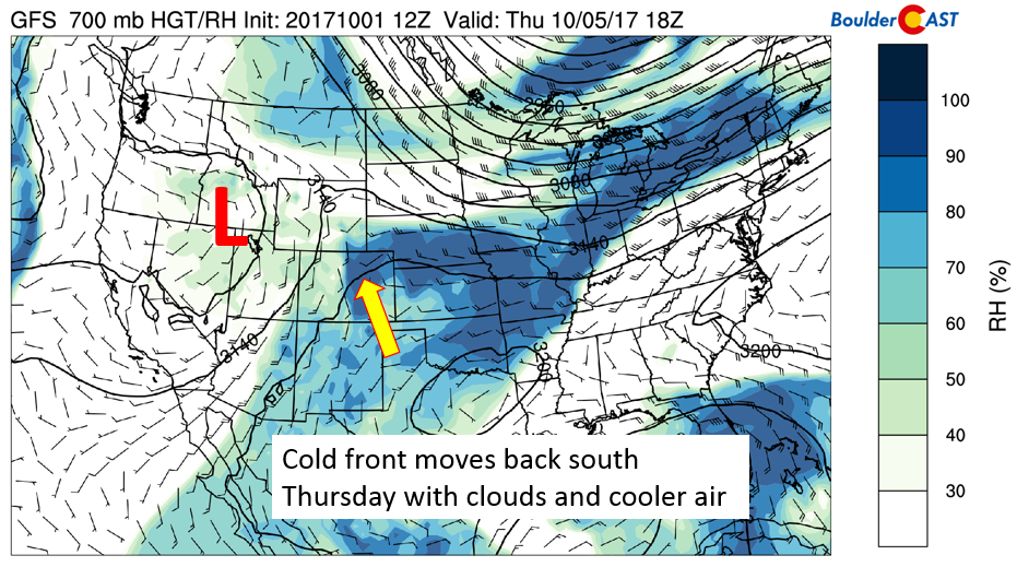
GFS 700 mb relative humidity on Thursday
On Friday, the GFS hints at the potential for downslope flow to return across Colorado, thanks to the low pressure positioned over Montana.
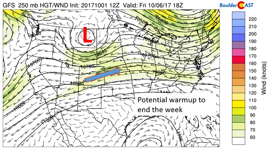
GFS 250 mb jet stream pattern
However, this solution is not shared by all global forecast models. The GFS 700 mb relative humidity and height pattern (bottom left) depicts the low pressure over the Dakotas Friday evening, with drier air filtering in over Colorado. This would spell out mild weather and lots of sunshine. The ECMWF model (bottom right), however, places the low pressure system over Utah, putting Colorado in a favorable region for lift, clouds, and below normal temperatures. Given the uncertainty, our current forecast calls for slightly moderating temperatures with a mix of clouds and sunshine Friday that may end with a chance of showers.
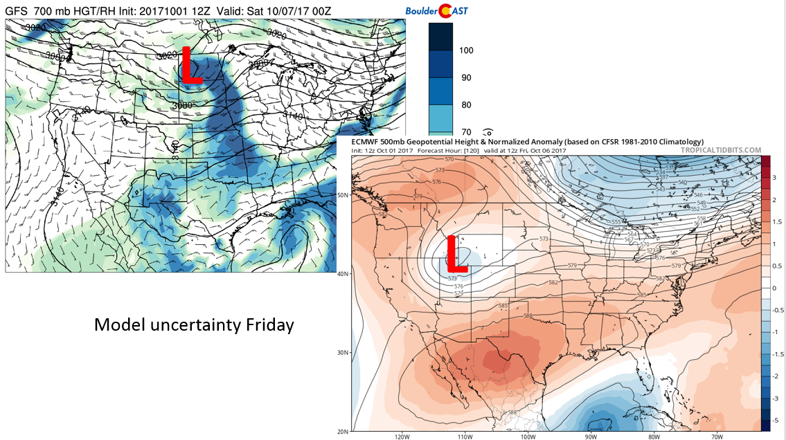
GFS (top left) and ECMWF (bottom right) forecasts for Friday
Forecast Specifics:
Monday: Overcast skies with rain showers and a few rumbles of thunder. Snow levels will be around 7,000 feet, with potential total accumulations by midnight tonight of 3 to 8″. Highs across the Plains will be chilly in the mid 40’s with mid 30’s in the Foothills.
Tuesday: Overcast skies with isolated drizzle possible in the morning, followed by partly cloudy skies in the afternoon. Highs will be in the mid 50’s on the Plains, with middle 40’s in the Foothills.
Wednesday: Mostly cloudy skies becoming partly sunny in the afternoon. Highs near the low 60’s on the Plains and in the low 50’s in the Foothills.
Thursday: Mostly sunny skies with a chance of isolated showers. Highs across the Plains will be in the upper 60’s, with mid 50’s in the Foothills.
Friday: Partly sunny skies along with a chance of late-day showers. Temperatures seasonal near 70 degrees on the Plains and upper 50’s in the Foothills.
Weekend: The overall weekend forecast will depend largely on the actual position of the trough Friday. Even with the uncertainty, though, temperatures remain warm Saturday into the 70’s as downslope flow ensues. Sunday is less certain with models hinting at another cold front advancing. Alas, the storm track has returned to Colorado!
High Country: Monday will be fairly snowy across the mountains, with 5-12″ of snow expected in northern Colorado. On Tuesday and Wednesday, windy and drier air filters in, along with slightly moderating temperatures. Winds at times in the high mountain peaks will exceed 40 mph through Wednesday. A slight chance of rain and snow exists Thursday and Friday. Get the latest forecast for the mountains over at our SummitCAST page.
DISCLAIMER: This weekly outlook forecast is created late Sunday or Monday morning and covers the entire upcoming work-week. Accuracy will decrease as the week progresses as this post is NOT updated. To receive daily updated forecasts, subscribe to BoulderCAST Premium.

Share our forecast:
Mon
Tue
Wed
Thu
Fri


Temperature
45
57
62
68
69


Precip Chc (Plains)
80%
10%
0%
10%(pm)
10%(pm)


You must be logged in to post a comment.