There is little weather to speak of for this first full-week of November with a ridge of high pressure over Colorado maintaining itself. There will be lots of sunshine and temperatures once again above normal…something which has been the story for much of our fall. One thing of note is a potential cold front late in the week, although it will likely not prevent us from remaining warmer than normal for this time of year. Read on for our full outlook of the week ahead.
Weak upslope flow to start out Monday
For today, the focus will be on a weak shortwave in western Kansas that was over us yesterday. It will be migrating eastward through the afternoon. Behind this shortwave is a ridge centered over Utah that will move east and park itself over Colorado through Wednesday.
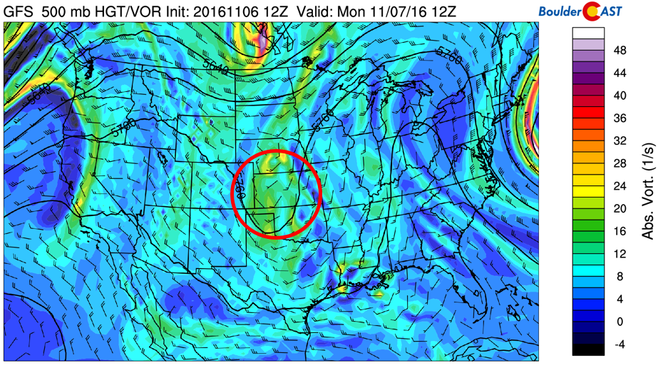
GFS 500 mb mid-level atmospheric flow for today
With the exiting shortwave, the Front Range will see light east-northeasterly flow which will keep temperatures “slightly” cooler than Sunday in the low to middle 60’s. Below shows the low-level (800 mb) flow for Monday, indicating the weak upslope flow that will keep us a tad cooler (but still above normal).
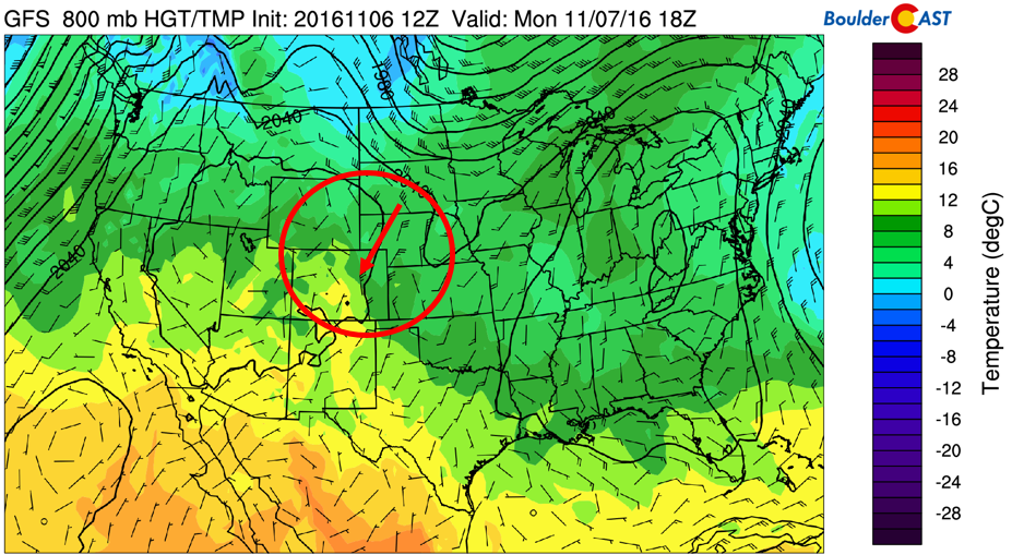
GFS 800 mb low-level temperature and winds for today. Arrow denotes the northeasterly upslope flow over the Front Range
Tuesday and Wednesday under the ridge of high pressure
On Tuesday and Wednesday, there is not much worthy of mentioning. The ridge of high pressure that was over Utah on Monday will migrate eastward and establish itself over Colorado these next few days. That will spell out warmer temperatures in the mid to upper 60’s Tuesday and low to middle 70’s on Wednesday. Good weather for our revered Election Day!
Thursday and Friday depend on a weak cold front
Late on Thursday, a large trough over the Great Lakes (circled in figure below) will bring down cold air over the northeastern United States. A small portion of this cold air will reach northeastern Colorado, as depicted by the “red arrow” in the figure below.
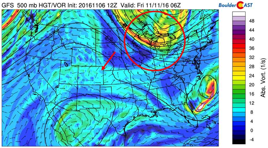
GFS 500 mb mid-level atmospheric flow for Thu night/Friday morning
A closer inspection of this potential cold front is shown in the 800 mb low-level temperature and wind pattern for Thursday afternoon and evening (figure below). Delineated in blue is the location of the cold front, with the red arrow showing the push of northeasterly cooler air from the Dakotas. The exact strength and position of this front will be tough to tell four to five days out, but nevertheless, we expect a slightly cooler end to the week compared to Tuesday and Wednesday, with highs in the low to middle 60’s.
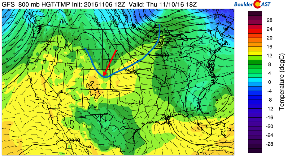
GFS 800 mb low-level temperature and winds for Thursday afternoon/evening
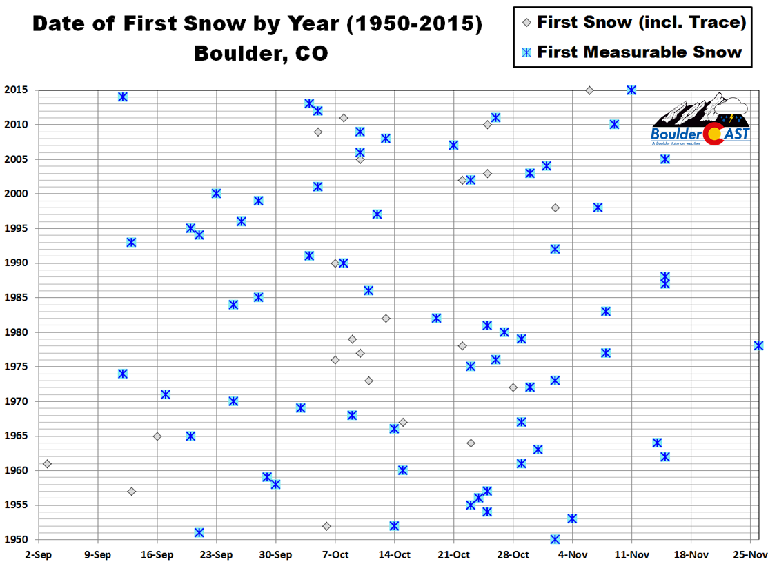
All in all, a quiet and mild week with again no threat of precipitation, even for the Mountains (sorry skiers!). Enjoy the weather while it lasts, as the climatological outlook we posted last week suggests a cooler mid to late November. In desperate anticipation for snow and cooler weather, we have updated our header image and logo to the “wintry” variants. Maybe that will finally help to coax a little snow out in the near future…it really is about time! We’re already within Boulder’s Top 10 years of latest first snowfall (since 1950). With no snow in the pipeline, we’ll be getting uncomfortably close to the latest on record (November 26).
Forecast Specifics:
Monday: A few high clouds early, then partly cloudy skies. High temperatures in the low to middle 60’s over the Plains and lower 50’s in the Foothills.
Tuesday: Mostly sunny and warmer. High temperatures in the upper 60’s over the Plains with upper 50’s in the Foothills.
Wednesday: Sunny skies and warmer, with above normal temps in the low 70’s across the Plains and low 60’s in the Foothills.
Thursday: Slightly cooler weather in the afternoon/early evening with a potential “cold” front moving through. Still plenty of sunshine, though. Highs in the middle 60’s on the Plains and middle 50’s over the Foothills.
Friday: Mostly sunny and mild. High temperatures near the low to middle 60’s over the Plains and lower 50’s in the Foothills.
High Country: The Mountains may see breezy conditions from the north Monday and Tuesday with the upper-level jet overhead. Wind gusts to 30 mph are possible, but nothing too terrible for early November. Other than that, expect no chance of precipitation with plenty of fair weather through the end of the week.
Extended: Model ensembles do not show the ridge of high pressure to break down much over the upcoming weekend. Though there are some signs that the jet stream will make a southward push by the middle of next week, which could trend our weather toward more seasonal temperatures. However, that far out, it remains to be seen. We will, as always, keep an eye on it!
Mon
Tue
Wed
Thu
Fri


Temperature
65
69
73
67
65


Precip Chc (Plains)
0%
0%
0%
0%
0%


