
This week’s weather will be rather tranquil, with temperatures overall above average for this time of year. However, we are watching a cold front for Wednesday and a trough late in the week that could bring snowfall to the region. We detail all this and more in our weekly outlook for the third week of November.
A mild start to the week
Let’s start with current conditions across the nation. Below is the mid-level 500 mb absolute vorticity, a “first look” of atmospheric systems impacting the United States. We have an area of low pressure over the Pacific Northwest, which will impact our region Tuesday night and Wednesday in terms of a cold front, and also a weak system over New England (which we really don’t care about).
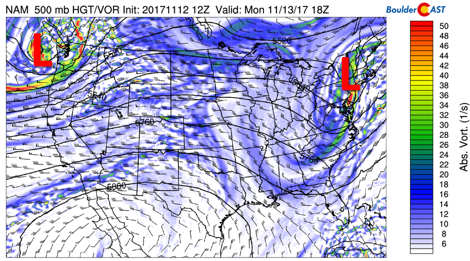
NAM model 500 mb absolute vorticity for today
Over Colorado today, southwest flow is present, along with a few embedded shortwaves bringing in mid to high-level clouds. Temperatures should be rather warm today thanks to downslope conditions extending from the Desert Southwest into eastern Colorado. Sunshine will also be widespread today resulting in upper 60’s in most areas.
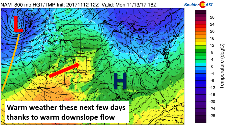
NAM model low-level temperature and height for this afternoon
Warmth continues Tuesday
Much of the same pattern persists into Tuesday. One exception is that the area of low pressure that was across the Pacific Northwest Monday will move into Montana by midday Tuesday. That will lead to a trough axis situated from northern Wyoming, southward into Arizona. We’ll likely see some high clouds streaming in thanks to westerly flow from the Pacific, but should still see enough sunshine to lead to upper 60’s once again.
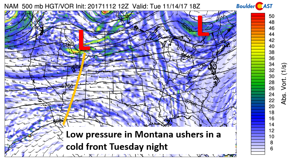
NAM 500 mb absolute vorticity for Tuesday
Weak cold front Tuesday night/Wednesday morning
Come Tuesday night, models show a weak cold front pushing south in association with the aforementioned low pressure system in Montana. By Wednesday morning, northeasterly flow will exist across the Plains and temperatures will be cooler, but certainly not cold. At worst, we are looking at temperatures similar to Sunday in the middle 50’s, close to average for November.
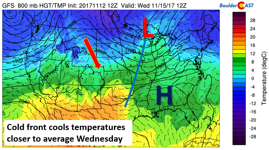
GFS 800 mb temperature, wind, and height Wednesday morning
Warmth returns briefly on Thursday
On Thursday, the models are showing yet another strong low pressure system hitting the Pacific Northwest. High moisture content, evident by the large relative humidity values across the northwest, will lead to widespread precipitation in this area. For Colorado, it will be a transition day. Southwest flow will return to bring temperatures likely back into the 60’s or low 70’s with clouds increasing through the day. We will also have to watch for some breezy conditions late in the day and night alongside another potential cold front.
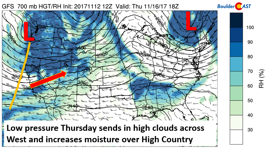
GFS 700 mb relative humidity (shaded), heights, and wind for Thursday
The persistent system in the Northwest will lead to precipitation totals in the 2-5″ range for Washington and Oregon, as well as the Sierras in California.
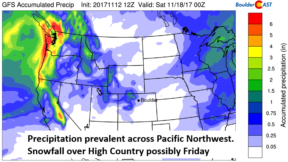
GFS total accumulated precipitation over the Western US through Friday
Friday trends colder with snow possible
The models are indicating some precipitation across the High Country in Colorado as well for Thursday into Friday.
The GFS model predicts the trough to reach Colorado early Friday. The Euro model, at the moment, is much slower, with its position across Nevada on Friday. Thus, there are differences, which will likely get resolved as the week progresses. Regardless, we should be on the look out for a changing weather pattern, with a trend toward colder weather, as well as snowfall for the High Country. This system could also bring rain/snow showers to the lower elevations, alongside increasing clouds, colder temperatures, and breezy northwest flow. More details will be divulged to our Premium members throughout the week.
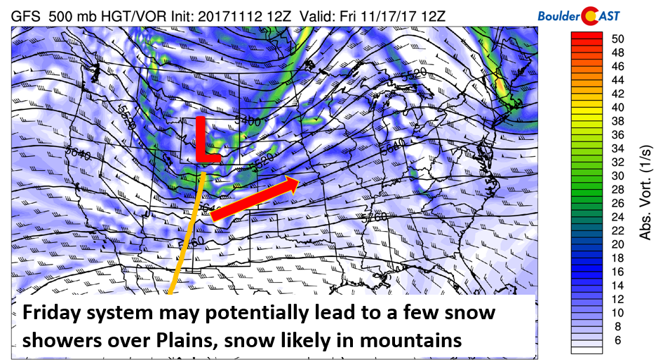
GFS 500 mb absolute vorticity on Friday
The current GFS forecast is showing that the High Country may see anywhere from 4-12″ of snow across Steamboat, with 2-6″ across the I-70 corridor. These amounts will likely change, so if you’re thinking about taking off work on Friday to go skiing, be sure to check our PowerCAST page for twice-daily forecast updates to plan ahead!
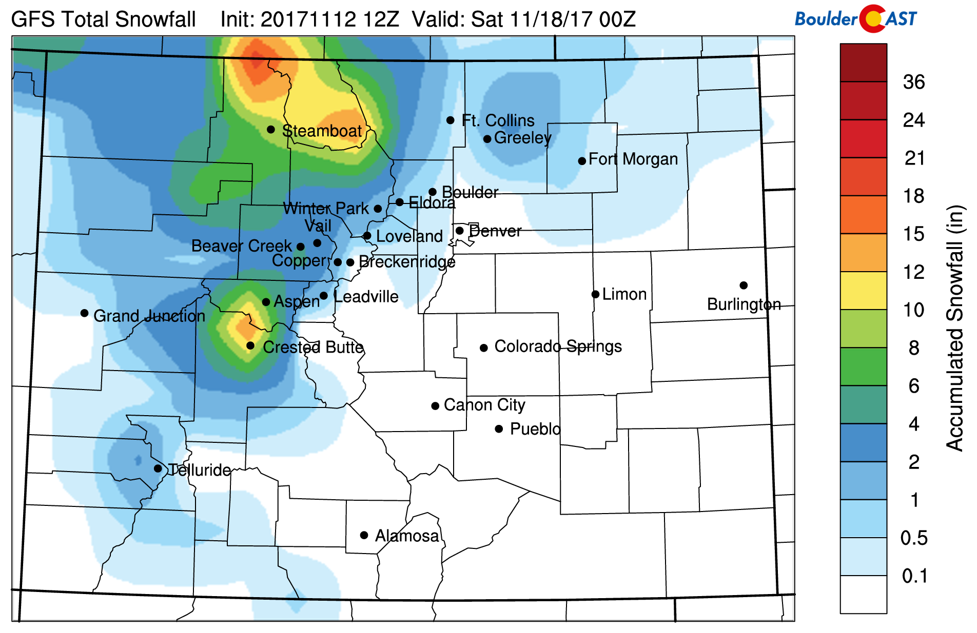
GFS predicted snowfall for Friday
Have a great week!
Forecast Specifics:
Monday: Sunny skies and warm. Temperatures in the upper 60’s across the Plains and lower 60’s in the Foothills.
Tuesday: Mostly sunny skies in the morning, with a mix of clouds and sunshine in the afternoon. Highs once again in the upper 60’s to near 70 on the Plains and lower 60’s in the Foothills.
Wednesday: Cooler and more seasonal. Partly cloudy skies with temperatures in the middle 50’s on the Plains and upper 40’s in the Foothills. East-northeast winds at 5-10 mph.
Thursday: Mostly sunny skies giving way to increasing afternoon clouds. Breezy conditions may exist later in the day. Highs in the middle 60’s over the Plains and middle 50’s in the Foothills.
Friday: Mostly cloudy, breezy, and colder. Rain/snow showers possible for the Plains, with snow showers in the Foothills. Highs in the 40’s or lower 50’s, with temperatures falling later in the day.
Weekend: The weekend will be calm with moderating temperatures thanks to a ridge of high pressure taking over.
High Country: Much of the High Country, with the exception of breezy conditions, will remain quiet through Wednesday. Increasing clouds and snowfall is possible Thursday afternoon into Saturday morning. Amounts are all over the place at the moment, anywhere from 4-12″. Find the latest forecast for all your favorite Colorado ski resorts on our PowderCAST page. Also, don’t forget we still provide daily forecasts for many alpine hikes via our SummitCAST page!
DISCLAIMER: This weekly outlook forecast is was created Monday morning and covers the entire upcoming work-week. Accuracy will decrease as the week progresses as this post is NOT updated. To receive daily updated forecasts, subscribe to BoulderCAST Premium.

Share our forecast:
Mon
Tue
Wed
Thu
Fri


Temperature
68
67
55
69
48


Precip Chc (Plains)
0%
0%
0%
0%
20%


