
Our weather turned quite warm to end the week, with Friday, Saturday and Sunday well above average in the 80’s across much of the Metro area. Unfortunately, this week will see a gradual drop in temperatures all thanks to a large cut-off low pressure system churning slowly across the Desert Southwest. It also looks to be a wet week overall, especially Tuesday and Wednesday. All the details can be found in our week ahead outlook, so read on…
Stormy weather starts the week
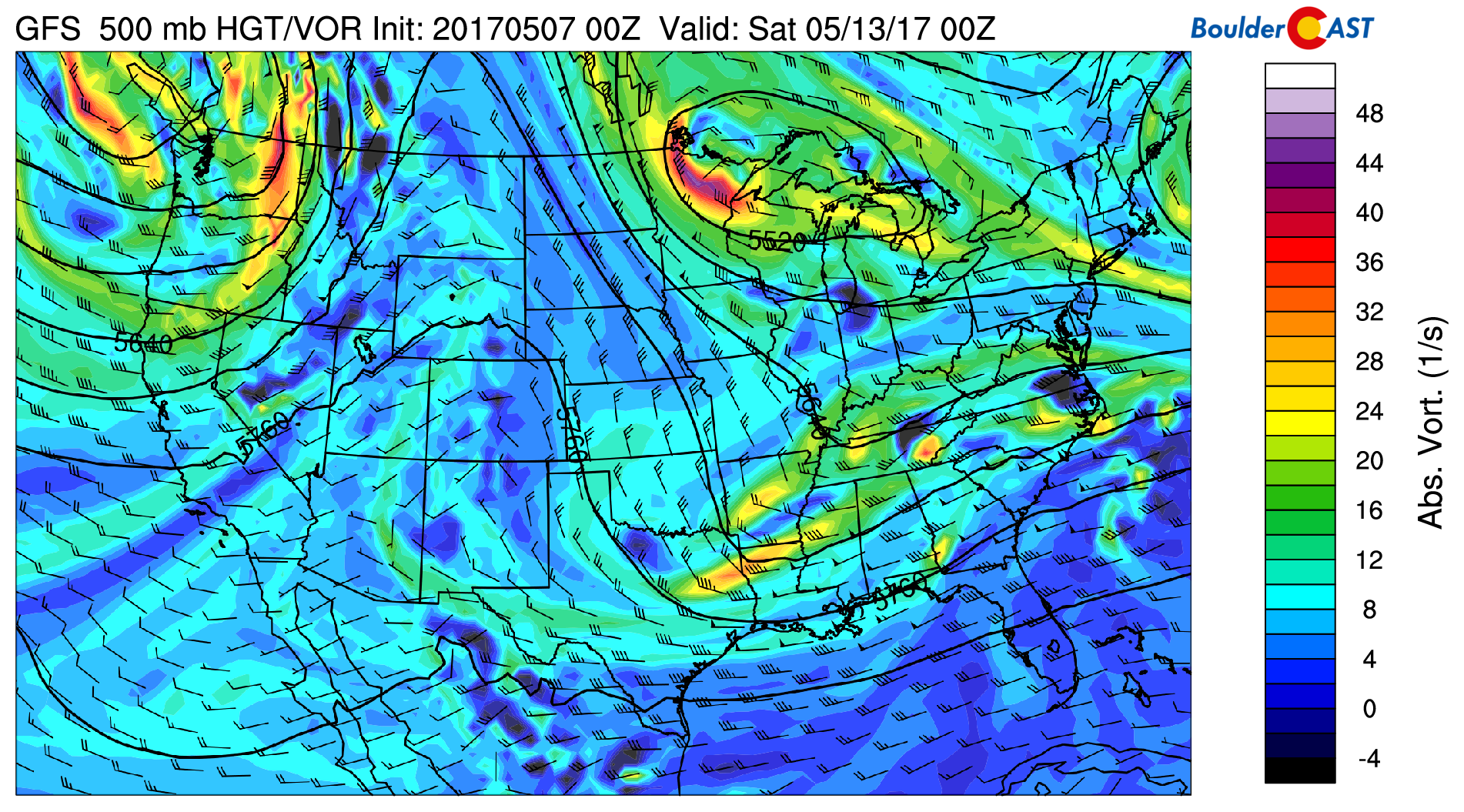
Below shows the current weather pattern in the mid-levels of the atmosphere for this afternoon/evening. A large cut-off low pressure system is near Baja California. The red arrow denotes the southerly push of subtropical moisture into our region from the Pacific Ocean. To the north over Colorado, weak lobes of vorticity are present in a region of diffluent flow.
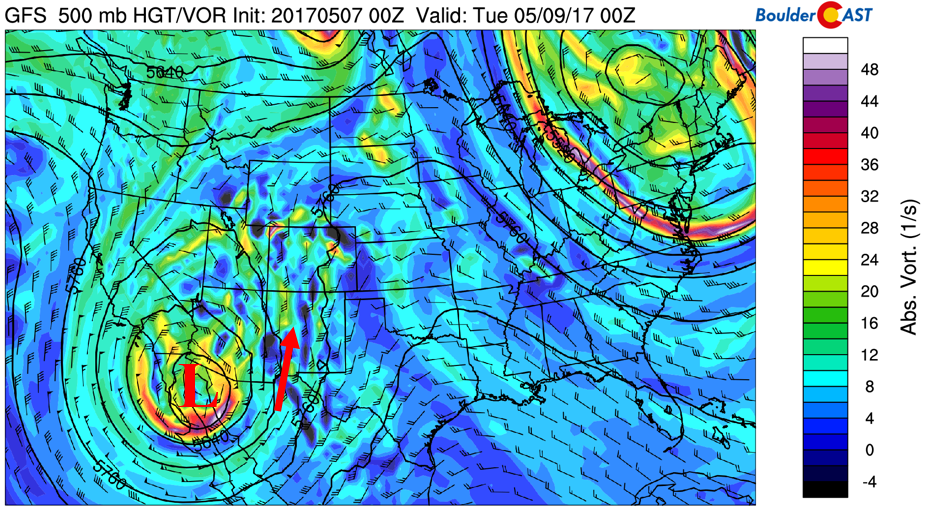
GFS 500 mb vorticity for this afternoon
We are expecting sunshine for the first half of today with temperatures rising to near 70 degrees. This somewhat cooler air is due to a weak cold front moving down from the north this morning. East-northeast surface winds will ensue today as a result and couple with the weak upper-level lift. In addition, low-level moisture will also be streaming in from the Gulf of Mexico, shown below.
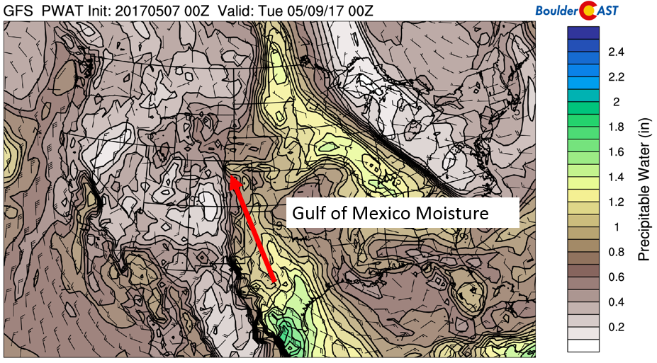
Precipitable water for this afternoon/evening
All factors point to clouds increasing this afternoon with widespread showers/storms developing. Some of these storms could be SEVERE, especially south and east of Denver as decent low-level directional shear will be in place along with very unstable air. The biggest threat this afternoon and evening will be damaging wind and hail in the 1 to 2″ range. Storm activity looks to taper off by late evening.

Severe storm outlook for Monday afternoon and evening | Storm Prediction Center
Tuesday and Wednesday are WET!
Tuesday and Wednesday will be quite rainy to say the least. Although we expect dry periods and breaks in the clouds here and there both days, we are thinking several factors are in place to warrant a hefty dumping of precipitation for the Front Range…
- Upper-level divergence with the jet stream overhead
- Copious amounts of moisture, near record levels for this time of year
- Instability from surface heating
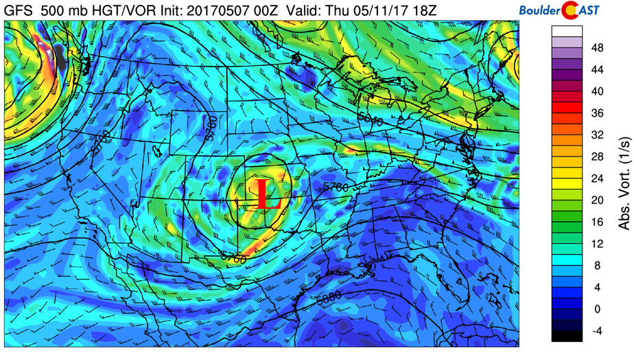
The upper-level pattern is shown below for Tuesday in terms of absolute vorticity at 500 mb (left) and 250 mb winds (right). The low moves off to the east slightly from its Monday position. A strong southerly flow remains, pushing in weak to moderate shortwaves that will fuel thunderstorm development. At the same time, there are two regions of divergence aloft from the jet stream that may also aid heavy rainfall and several periods of showers. This is visible in the bottom right figure. Two areas are highlighted in blue. Northeast Colorado is in the left exit region of the southern jet stream, and in the right entrance region of the jet over Wyoming and Nebraska. This also favors strong lift for sustained precipitation.
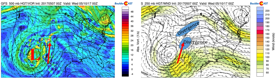
GFS 500 mb vorticity (left) and 250 mb jet stream pattern (right) for Tuesday
In addition to the upper-level forcing, we also mentioned instability and moisture. Shown below is the total column moisture (precipitable water) over the United States. The red arrows outline the origin of the moisture reaching northeast Colorado Tuesday and Wednesday. Precipitable water levels creep towards one inch both days. This is remarkable for early May. In the low-levels, east-southeast upslope flow ensues as well, which will favor orographic forcing and lift.
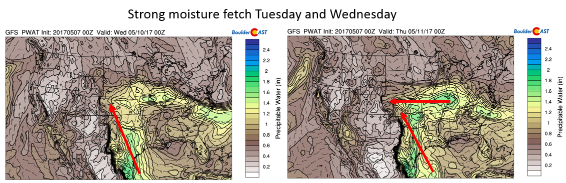
Moisture pattern for Tuesday (left) and Wednesday (right) in terms of precipitable water
How much rain are we talking? Well, it depends which forecast model you look at. The Euro model shows 1 to 2″ of rainfall by Thursday, whereas the GFS (figure below) shows as much as 3 to 4″, almost a doubling of the amount predicted by some other models…
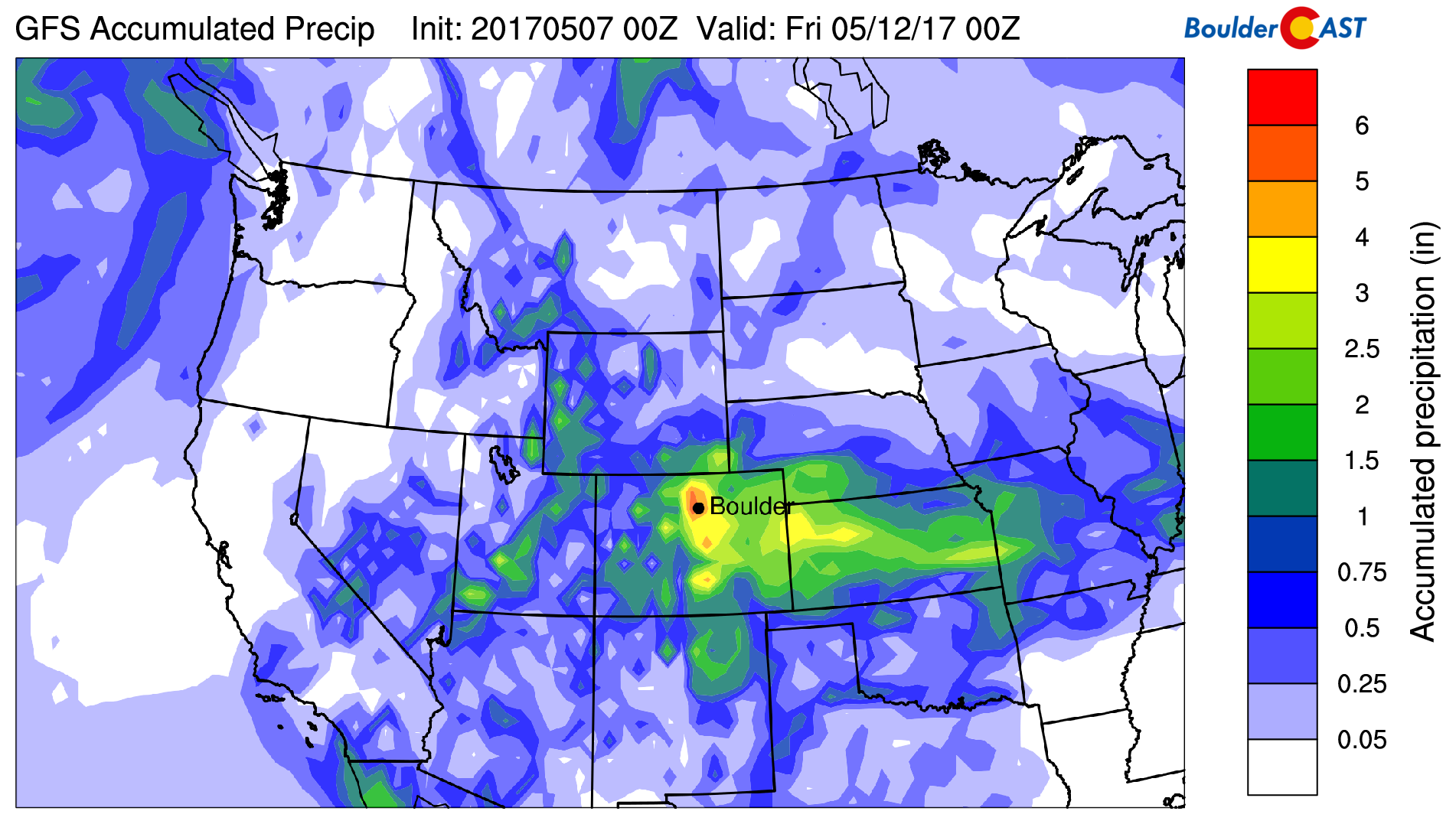
GFS accumulated precipitation by Thursday
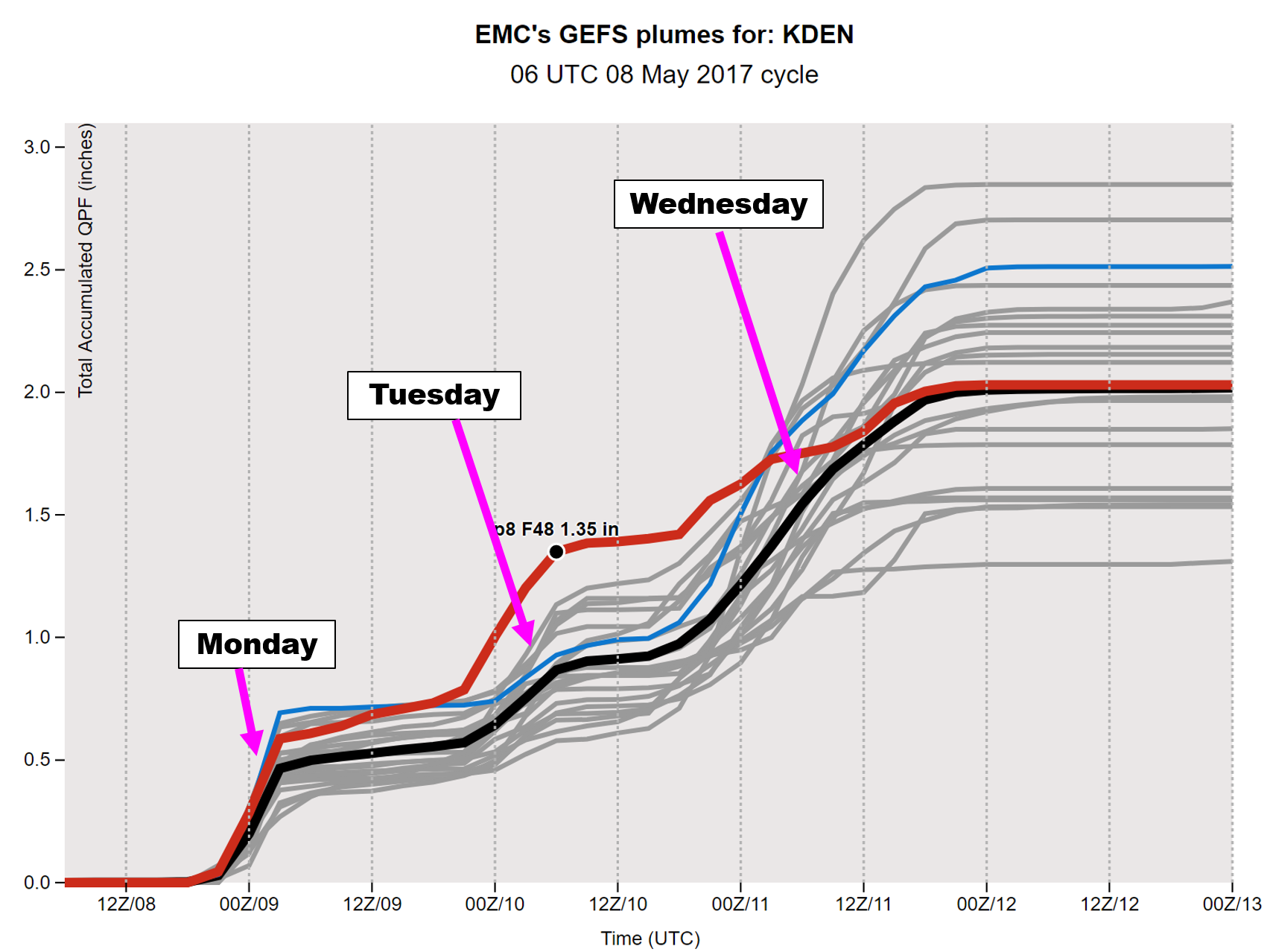
The GFS ensemble plumes for Denver show a mean of 2″ of rain for the week ahead, with amounts ranging from 1.5 to 3.0″ overall. This would be SUBSTANTIAL for the region, comprising ~15% of our annual precipitation.
Needless to say, we’re going to have to see how this all plays out. Conditions are definitely primed to see at least an inch or more of rain by Thursday. As a result of increased cloud cover and precipitation, highs likely will be in the 60’s both Tuesday and Wednesday.
This system is mostly subtropical in nature (we’ll see days of southerly flow in the mid levels), and therefore, there is not much cold air in the mix. Although most of the precipitation will fall as rain, the high mountain peaks will see some snow thanks to a little bit of cold air around the core of the low pressure system. The GFS model is forecasting 3 to 8″ of snow across portions of the High Country. Snow levels will start out around 11,000 feet on Tuesday and Wednesday, but fall to around 8,500 feet Wednesday night and Thursday morning. Thus, we don’t expect ANY snow on the Plains this week…
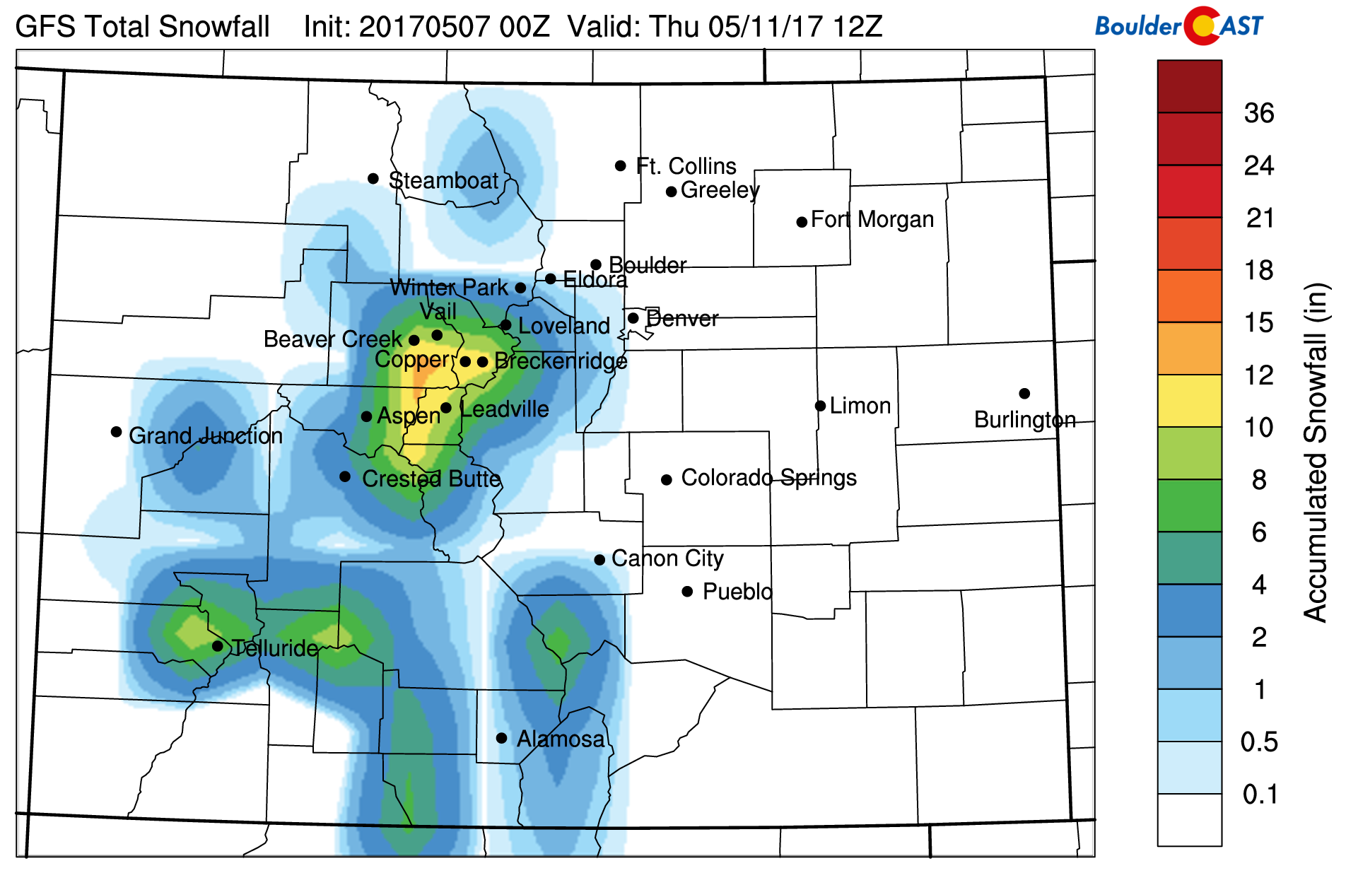
GFS snowfall accumulation through Wednesday
Thursday and Friday turn slightly drier and warmer
The low pressure system depicted in both the Euro and GFS models is forecast to move into the Oklahoma panhandle by Thursday afternoon. Northeast flow, however, is predicted to remain for at least part of the day on Thursday so that a few showers and storms are not out of the question. There would likely be some cloud cover in the low-levels if the rainfall from Tuesday and Wednesday comes to fruition (moisture feedback). Furthermore, low-level temperatures are somewhat chilly behind the system. Expect a chance of showers with eventual clearing later in the day and temperatures cool in the upper 50’s.
GFS 500 mb vorticity for Thursday
On Friday, high pressure builds in from the west. With that, lots of sunshine can be expected for at least part of the day. Low-level flow will probably still be out of the east-southeast. The forecast could change between now and Friday, but as it stands, instability and moisture still in place will favor isolated storm development Friday afternoon and evening. Temperatures, though, should rise back into the 70’s. This weather will carry into the weekend as well!
GFS 500 mb absolute vorticity for Friday
Forecast Specifics:
Monday: Mostly sunny skies giving way to increasing clouds with scattered to widespread storms, some of which could be severe south and east of Denver. Large hail and strong wind gusts in excess of 60 mph are the main threat. Highs near 70 for the Plains and in the low 60’s in the Foothills. Storms should taper off before midnight.
Tuesday: Partly sunny in the morning, then mostly cloudy with showers and thunderstorms developing in the mid to late afternoon and continuing into the evening and overnight. Locally heavy rain is possible. Temperatures will be in the mid 60’s across the Plains and in the lower 50’s in the Foothills.
Wednesday: Morning cloud cover to give way a mix of clouds and sun. Periods of showers will develop by late afternoon and continue into the evening. Some thunderstorms are also possible and locally heavy rain may occur once again. Highs near the low 60’s for the Plains and low 50’s in the Foothills.
Thursday: Mostly cloudy and foggy in the morning, with more sunshine later in the day. This sunshine could fuel isolated afternoon storms across the region. Temperatures will rise to near 60 across the Plains, with low 50’s in the Foothills.
Friday: Lots of sunshine in the morning and early afternoon. Isolated thunderstorms possible though by late afternoon/early evening. Highs should reach the middle 70’s on the Plain and middle 60’s in the Foothills.
High Country: Stormy weather is the story for much of the week, with the exception of Thursday. Expect rounds of afternoon/evening storms each day. Tuesday and Wednesday will turn cold enough for snow to fall in the peaks above 10,000 feet, dropping to around 8,500 feet by Thursday morning. A general 3-8″ can be expected in the Mountains. If you are going hiking, the best times would likely be Thursday or early Friday.
Weekend: The upcoming weekend is showing a high pressure pattern across Colorado. That will favor a return to mild weather across the region. However, there will still be plenty of low-level moisture and weak upslope flow. That combined with weak instability will favor isolated thunderstorms over the weekend. It doesn’t appear to be significant and should not put a damper on your weekend plans. But if you’re heading to the High Country, it might be best to start early in the day to avoid any storms.
Don’t be selfish…share our forecast with your friends!
Mon
Tue
Wed
Thu
Fri


Temperature
70
63
64
60
75


Precip Chc (Plains)
70%
60%
70%
20%
0%


You must be logged in to post a comment.