
Following our first summer-like weekend of the year, the focus for the week ahead will be unsettled weather and a chance of storms each and every day, with seasonal temperatures in place through the week. Read on for our complete forecast for the next five days.
What beautiful weather we had across the Front Range this past weekend. There was plenty of sunshine to go around, and no rain in sight. This was the view from the Flatirons on Saturday.
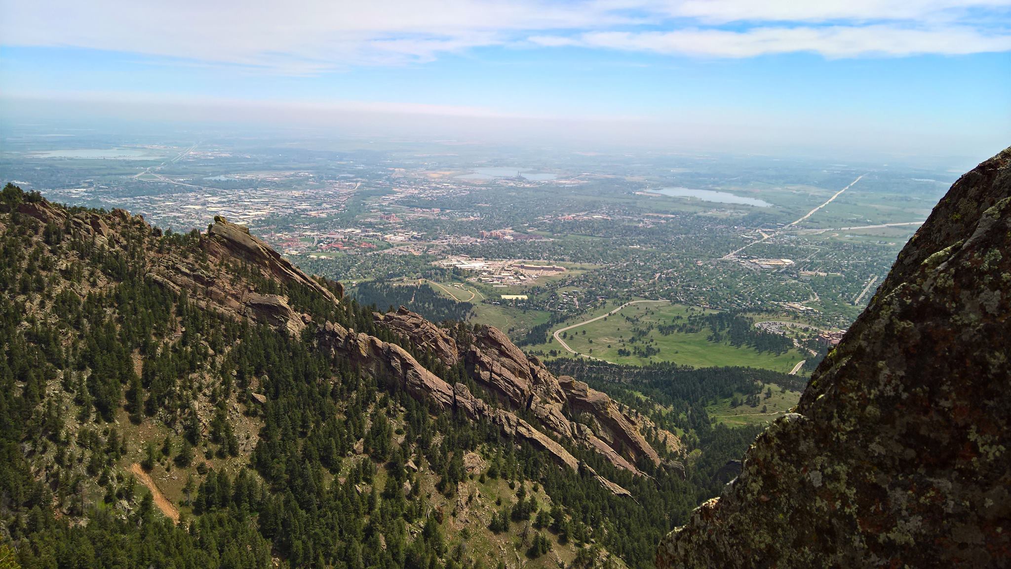
Sunshine was plentiful on Saturday, great for climbing the Flatirons
Stormy is the word
Looking to the week ahead, the weather will turn unsettled as an upper-level trough lingers and spins to our north and west. The trough’s current location can be seen below, centered across Oregon.
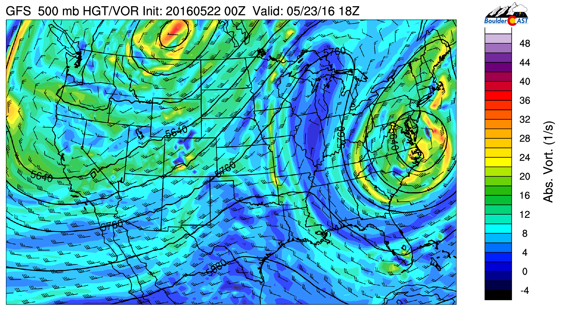
Notice the large fetch of southwesterly flow heading into Colorado. This will feed some moisture into the region throughout the week (combined with low-level southeasterly flow for Gulf moisture), allowing for afternoon thunderstorms to form each and every day. The best chances will be over the higher terrain AND well northeast of Denver, but the Front Range Plains will be at risk for isolated storms as well.
Little will change between Monday and Wednesday for our weather. Expect afternoon scattered storms over the Mountains/Foothills, with isolated storms over the Plains. Highs will be in the upper 60’s today, with low to mid 70’s for Tuesday and Wednesday. For the gamblers, we’ll say ~40% chance of rain in Foothills, with ~20% each day on the Plains.
Shortwave arrives Thursday
By Wednesday, a piece of energy begins to materialize across southern California. This is visible in the 500 mb vorticity map below for Wednesday afternoon.

GFS 500 mb vorticity map for Wednesday, showing a weak system beginning to materialize across southern California.
This embedded, shortwave energy will help to enhance storm activity across Colorado Thursday evening and night. You can see what it looks like below as it moves across Colorado late Thursday.

GFS 500 mb vorticity map, valid Thursday night at midnight. The circled piece of energy will help kick off more storms, even during the overnight hours into Friday
The nighttime timing of the wave for the Front Range would reduce it’s overall impact (lacking daytime heating to further enhance storm formation). However, it is a vigorous wave, so we should see some storm activity continue through the night as it passes. Still four days out, nothing is set in stone, especially the specifics on timing. For now, expect a bump in precipitation chances both Thursday and Friday.
Thursday will again be near 70 degrees for temperatures with afternoon storms. We expect storm coverage to be higher, particularly in the evening and overnight into Friday morning, compliments of that shortwave feature.
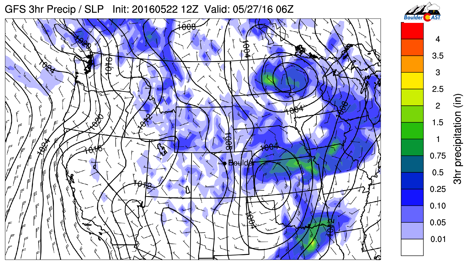
GFS precipitation forecast for Thursday night at midnight. Notice the widespread nature of the storms across Colorado, thank to the passing shortwave
There will also be a weak cold front tied to this system. Models show this front arriving sometime during the day Thursday. This will cool things off for Friday and keep the threat of storms around right through the weekend. Friday’s high will be in the mid 60’s.
There is some model variation with this system. Most notably, that the Euro model is running several degrees colder Thursday night behind the front (see below). This would support lower snow levels. Blending the two solutions, we’re not expecting much in the way of accumulating snow. However, it wouldn’t be surprising to see a few flakes mix in with the rain for the higher Foothills Thursday night.
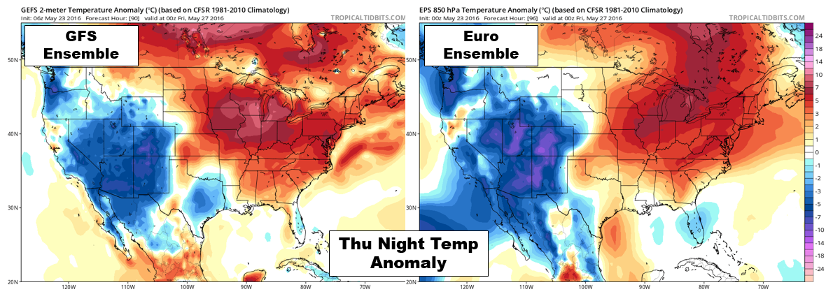
Models are not in good agreement for how cold Thursday/Friday’s airmass will be. The Euro is much colder than the GFS.
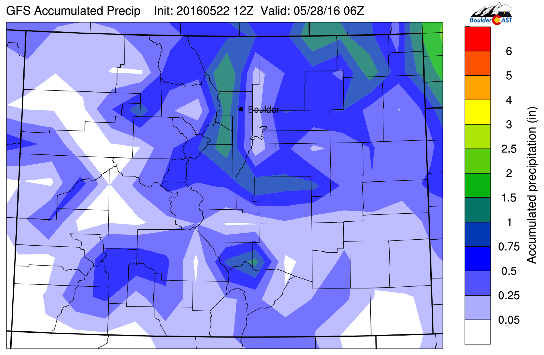
The GFS total accumulated precipitation forecast shows the potential for some areas to exceed 1″ of rain through Friday. Likely locales are in the Foothills and well northeast of Denver. Admittedly, rain amounts will vary significantly from location-to-location with the convective nature of this week’s storms. Heavy rain in the higher elevations will need to be monitored towards the week’s end. With snow melt in full-swing, flooding may be a concern.
Severe threat?
This time of year, as troughs move into the Great Plains, we also need to keep watch for the development of severe storms. While we don’t see any major outbreaks on the horizon, the area northeast of Denver could see a couple supercells Tuesday and Wednesday afternoon. The most concerning day for us is Thursday as the shortwave passes. Depending on timing and if it can align with daytime heating, conditions just might be favorable for some severe weather in the Denver Metro. Check back later in the week when timing and details are more clear.
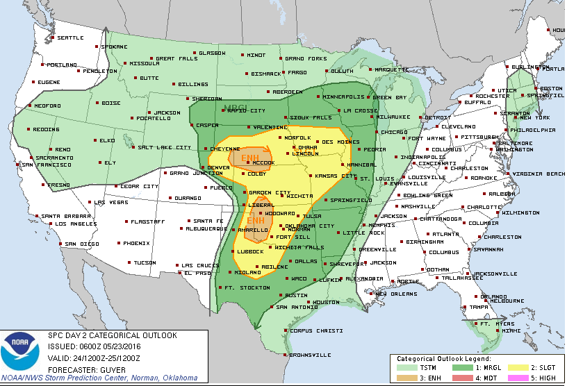
Severe weather outlook for Tuesday, showing Enhanced Risk in the NE corner of Colorado | Storm Prediction Center
Summary
All in all, not a bad week in general. Days will largely be dry with at least partial sunshine before a few storms start popping up. We’re not expecting any total washouts. But as we mentioned, Thursday evening and Friday will be the “wetter” times.
Have a great week!
The Forecast:
Monday: Increasing clouds with scattered afternoon storms forming over the higher terrain. Isolated storms across the Plains. High in the upper 60’s across the Plains, with upper 50’s in the Foothills.
Tuesday: Increasing clouds with scattered afternoon thunderstorms. A few storms well northeast of Denver could become severe. Highs in the low 70’s across the Plains with mid to upper 50’s in the Foothills.
Wednesday: Partly cloudy with hit-and-miss afternoon thunderstorms. A few storms well northeast of Denver could become severe. Highs in the middle 70’s on the Plains, with low 60’s in the Foothills.
Thursday: Some sun early, then mostly cloudy. A cold front arrives during the day. Expect fairly widespread storms in the evening, continuing overnight into Friday. High near 70 degrees on the Plains, with upper 50’s in the Foothills.
Friday: Mostly cloudy with scattered showers and a few storms throughout the day. Cooler with a high temperature in the mid 60’s for the Plains, low 50’s in the Foothills.
High Country: Hit-and-miss showers and storms through Wednesday. Storms then become fairly widespread for both Thursday and Friday. Snow levels remain high, above 10,000 feet through the week, with only minor accumulations possible on the highest peaks. Snow pack (which now sits at 150% of normal!) will continue to decline across the region. Depending on how things materialize for Thursday/Friday, flooding could become a concern if rain becomes as widespread as some model runs are showing.
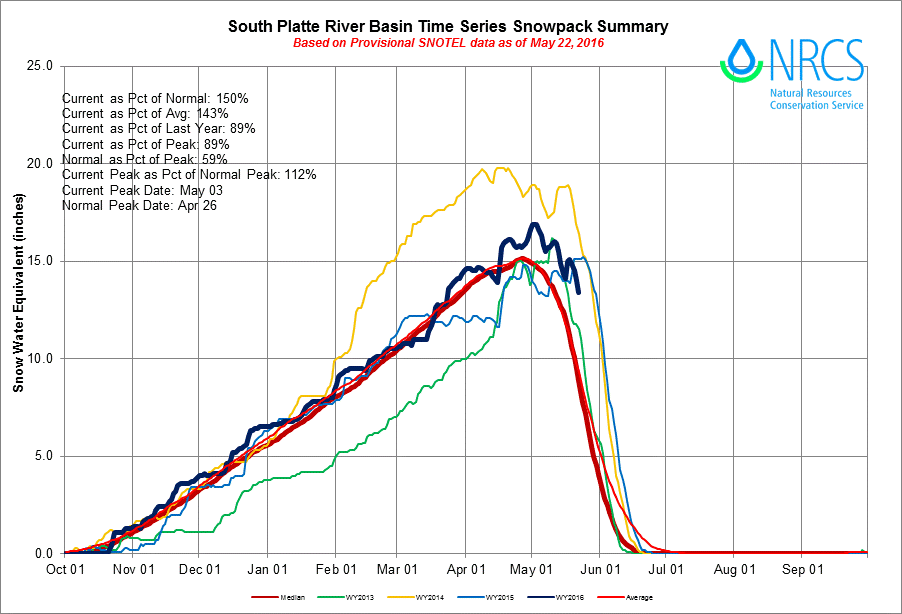
Current seasonal snowpack graph for the South Platte River basin


