This week’s weather will fail to outdo last week’s historic snow storm, but nonetheless the pattern remains active across Colorado. The week starts off with a cold frontal passage Monday evening, followed by at least one nice day under the influence of high pressure. Storm activity under southwest flow returns towards the end of the week, though. We also cover the forecast for the upcoming holiday weekend and the BolderBoulder. Continue reading for the details.
Cold front to start our Monday
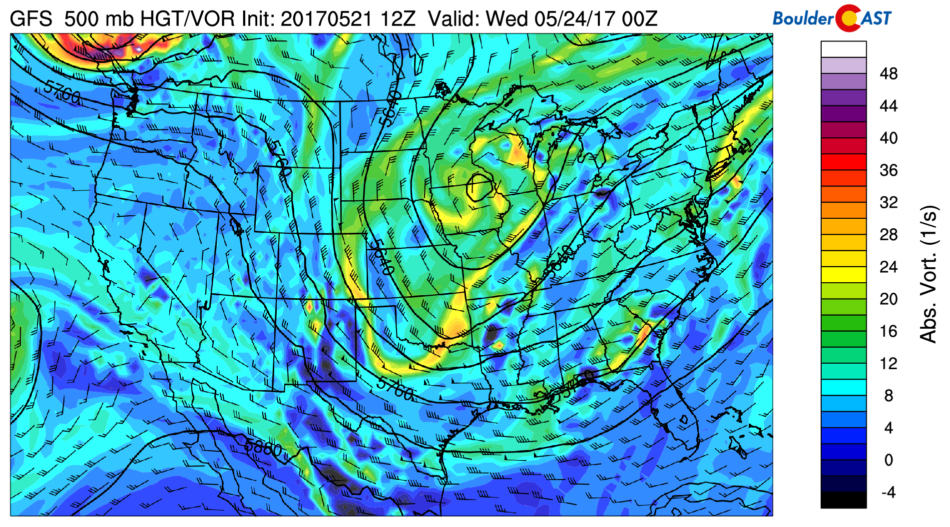
We begin the week under the influence of northwest flow at the 500 mb level (see below). An area of low pressure exists over Lake Superior. As noted by the arrows, counter-clockwise flow is present around this system, ushering in cooler air tonight from Canada. In addition, shortwave energy around this trough will aid showers later this afternoon and tonight along the frontal boundary.
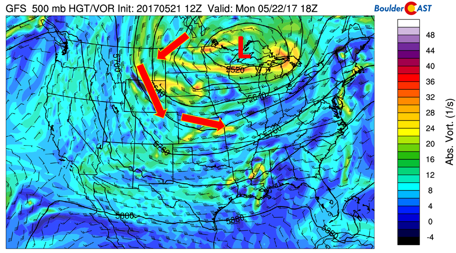
GFS 500 mb absolute vorticity this afternoon/evening
Below shows a zoom-in of the cold front at the near-surface level from the NAM model. Arrows depict the air-flow from the north to the south. The blue line indicates the frontal position by 6PM this evening. Notice the sharp delineation between the cold and warm air, and gusty winds behind the front of up to 35 mph . The front should pass through by early evening, with showers commencing during that time frame. Expect a quick warm-up to start our day under partly cloudy skies in the low to middle 60’s, then turning cooler into the 40’s by late evening. We will likely drop to the low 40’s overnight and possibly some upper 30’s in the outlying areas.
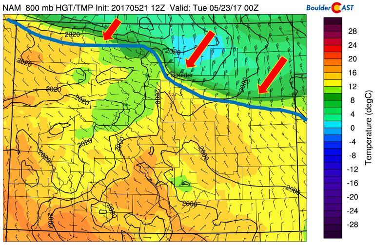
NAM near-surface frontal boundary this evening, along with temperature and wind
As forecasted by the GFS, showers will encompass much of the state by tonight. Some of them could produce thunder but nothing will be severe, or even all the strong.
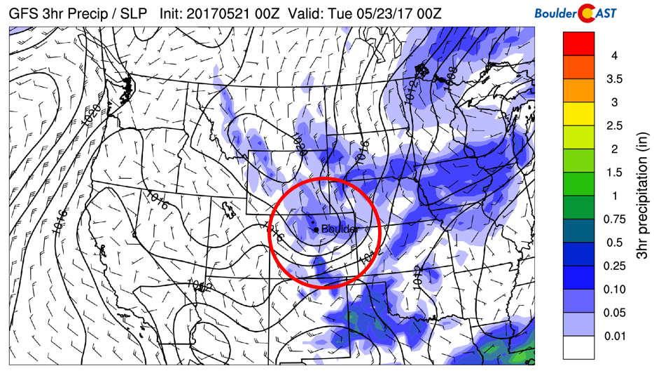
GFS regional precipitation at 6 pm tonight
The front will also produce more mountain snowfall. In case you didn’t see the pristine white conditions in the High Country Sunday, a fresh coating of snow will form once again tonight, with 2-5″ possible above 9,000 feet. An inch or two of snow will also be possible above 7,000 feet in the Foothills.
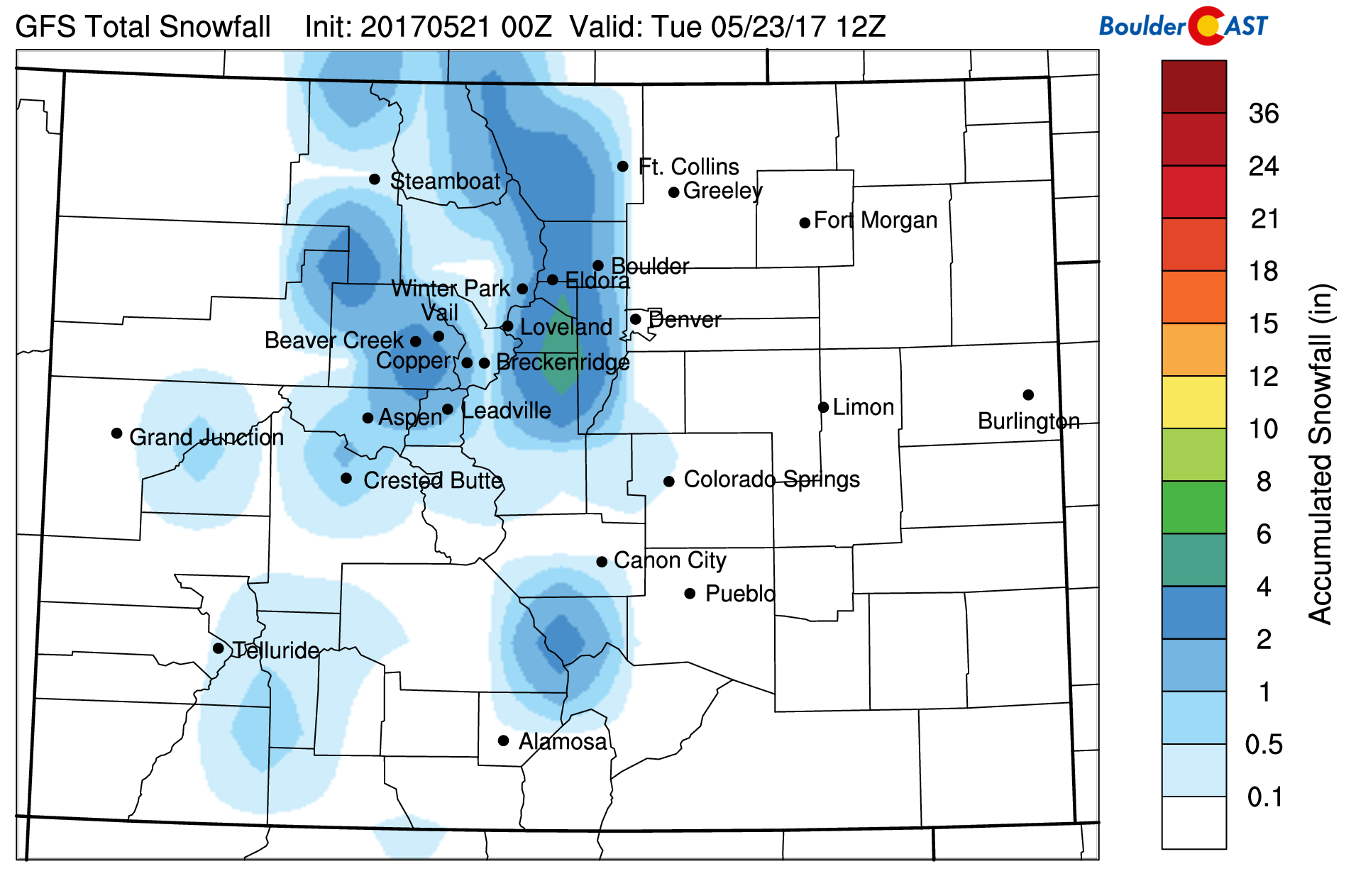
GFS accumulated snowfall through Monday night
A quiet Tuesday tells the story…
On Tuesday, the mid-level pattern will see northerly flow over much of our beautiful state as low pressure shifts off to our east. Behind it, surface east-northeasterly flow ensues with dry and cooler air. Highs should hover around the lower 60’s, a tad cooler but beautiful under partly sunny skies.
GFS 500 mb absolute vorticity for Tuesday
You’re gonna want to get outside Wednesday!
By Wednesday, a ridge of high pressure builds east over the Four Corners region (see below). In addition, an area of low pressure will exist over southwestern Canada, with southwest flow ensuing around that system. Keep in mind, this will be a player for us later in the week.
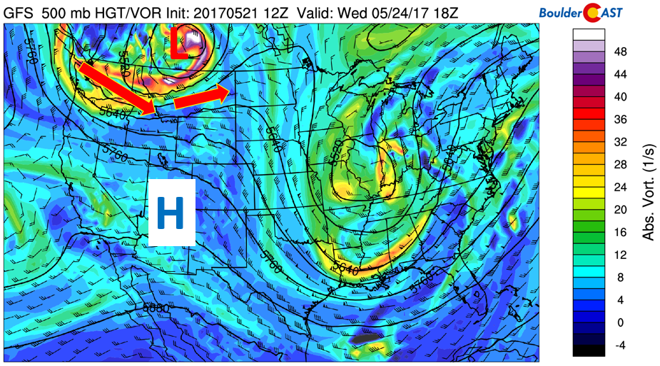
GFS 500 mb absolute vorticity for Wednesday
The high pressure will allow strong warming to occur in the low-levels and the surface. The 700 mb temperature pattern (see below) indicates warm air spreading in from the Desert Southwest. At the same time, low pressure still exists in southern Canada with northwesterly flow and cold air moving into Montana and Idaho. This pattern will spell out highs potentially touching the low 80’s for our region!
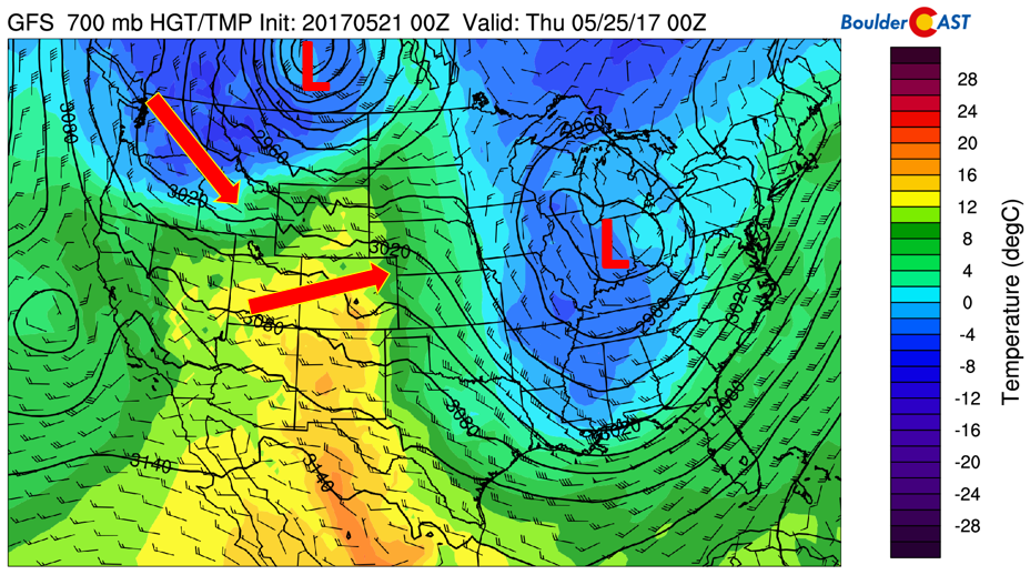
GFS 700 mb temperature, height, and wind for Wednesday
At the surface, the southwesterly flow aloft will lead to a lee trough, indicated by the orange line in the figure below. This trough connects with the low pressure over Canada and extends as far south as New Mexico! The green arrow depicts westerly downslope flow. This is prime for warming on Wednesday and we should expect lots of sunshine with the sinking air. Enjoy! Wednesday might be a good day to play hookie from work, Ferris Bueller style!
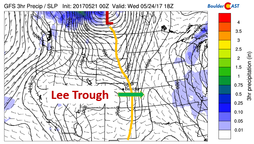
GFS sea-level pressure pattern and winds for Wednesday
Thursday and Friday are troughy
Come Thursday and Friday, our region will be under the influence of that low pressure out of Canada. This will continue to produce southwest flow over the state (see below). Around the base of the trough, which will be positioned over Nevada, Utah, and Colorado, waves of energy will traverse west to east. This combined with daytime heating will lead to the threat of afternoon/early evening showers and storm activity across the Plains and High Country.
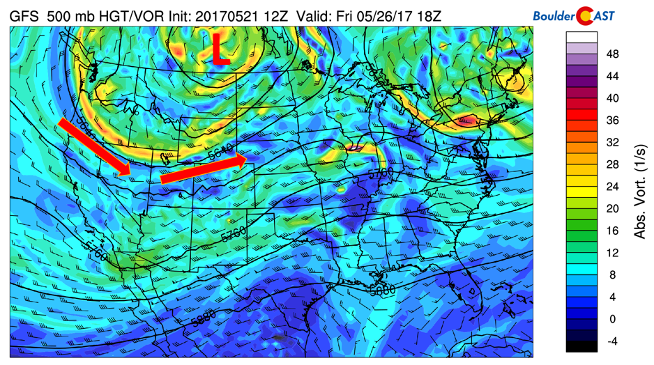
GFS 500 mb absolute vorticity pattern Thursday and Friday
Pinpointing the exact location of these storms will be tricky and difficult at best this far out. But needless to say, we should be on the look-out for unsettled afternoon/early evenings late in the week. The below plot shows the precipitation Thursday evening, with two areas of low pressure, one over Canada, and another over the Oklahoma Panhandle. This southern flank system will be something to keep an eye on as it may anchor a weak cold front Thursday. If that occurs, upslope flow at the surface could enhance precipitation chances.
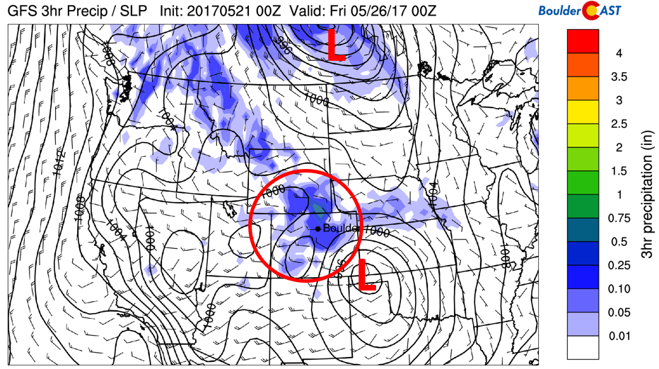
GFS sea-level pressure and precipitation Thursday evening
More or less the same weather setup will exist on Friday (see below). Much of the uncertainty in the precipitation threat Thursday and Friday should get flushed out in the next few days and our Premium subscribers will be the first to hear the finer details. Highs both days should be in the low to middle 70’s.
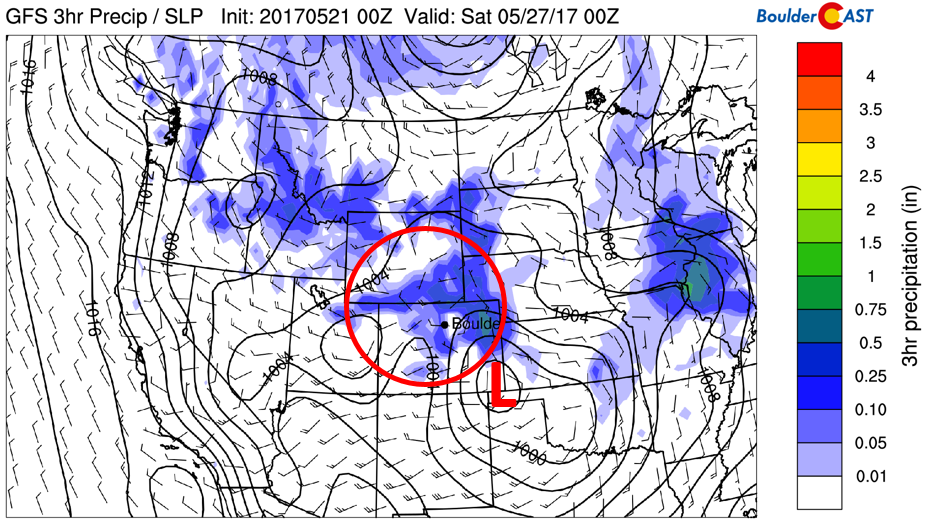
GFS precipitation for Friday
Memorial Day weekend forecast
Over the weekend, the Memorial Day celebration commences, along with the BolderBoulder. Over the past few years of the race, we have had a variety of weather, from hot and sunny (2016, 2014, 2013), to cold and rainy (2015), to windy conditions which cancelled the patriotic paratroopers!
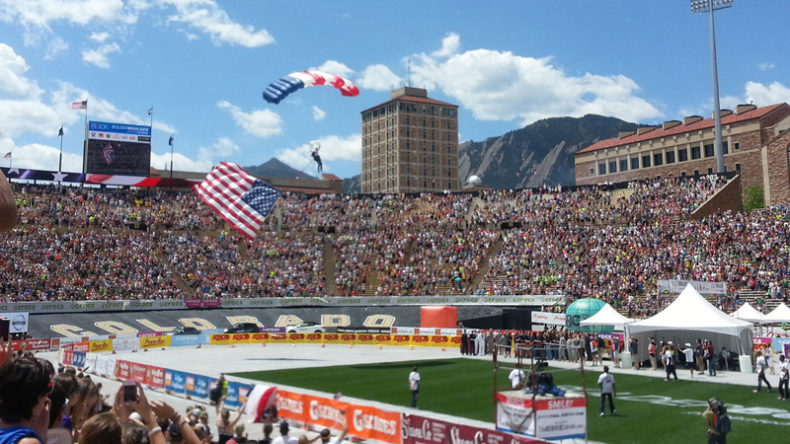
Boulder’s annual BolderBoulder is on Memorial Day, Monday, May 29th!
Unfortunately, both Saturday and Sunday look unsettled across our region with the potential for significant afternoon shower and storm activity. Expect temperatures in the 60’s both days. Will this gloomy forecast also linger into Memorial Day itself?
Below shows the forecast pattern from the Euro and GFS models. In the mid-levels, the Euro has a weak trough over the Great Lakes, with high pressure over Wyoming (left). At the same time, the GFS surface sea-level pressure pattern also indicates high pressure over Wyoming. The arrows depict clockwise flow around the high pressure. This pattern would favor a dry and cool upslope flow on Memorial Day. That would be a perfect forecast for the holiday as it would likely be partly cloudy and mild in the 60’s. We’ll fill you in for when the holiday gets closer!
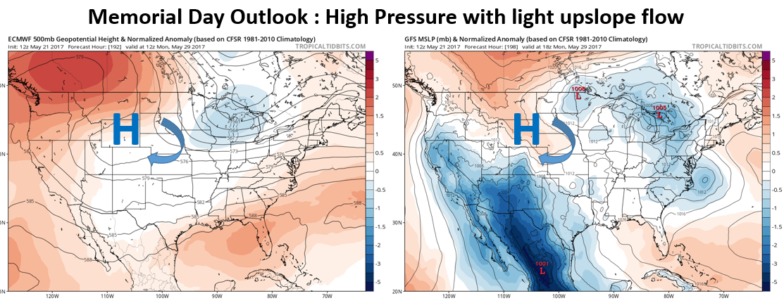
ECMWF (left) and GFS (right) mid-level and surface pattern for Memorial Day
Forecast Specifics:
Monday: Sunny skies giving way increasing clouds. Scattered showers developing in the mid to late afternoon, becoming widespread in the evening and diminishing before midnight. A few rumbles of thunder are possible. Gusty winds up to 40 mph will accompany a cold frontal passage between 3PM and 7PM. Snow levels will fall to around 7,000 feet during the evening, with an quick inch or two of accumulation possible in the Foothills above this level. Highs in the low to middle 60’s on the Plains and in the mid 50’s in the Foothills.
Tuesday: Clouds in the morning, then partly sunny in the afternoon. Temperatures will be in the lower 60’s across the Plains and in the lower 50’s in the Foothills.
Wednesday: Mostly sunny and much warmer. Highs near the low 80’s for the Plains and low 70’s in the Foothills.
Thursday: Mostly sunny skies giving way to increasing afternoon clouds and scattered storm activity. Expect temperatures to top out in the low 70’s across the Plains, with low 60’s in the Foothills.
Friday: Sunny skies becoming partly sunny with isolated showers and thunderstorms possible in the late afternoon/evening. Highs will be in the low 70’s for the Plains, with upper 50’s in the Foothills.
High Country: Snow showers will penetrate the mountains Monday night, with 2-5″ of fresh powder by Tuesday morning. Tuesday and Wednesday are tranquil. Thursday and Friday will be quite active with scattered showers and thunderstorms in the afternoon/evening. Some will lead to snowfall as well on the higher peaks.
Don’t be selfish…share our forecast with your friends!
Mon
Tue
Wed
Thu
Fri


Temperature
63
62
80
73
71


Precip Chc (Plains)
70%(pm)
0%
0%
40%
40%


