
More unsettled weather is looming for the week ahead! We’ll squeeze out a few nice days to start, but temperatures will be tumbling by mid week as a formidable storm system heads towards Colorado. Thursday and Friday’s forecast is currently shrouded in a bit of uncertainty, by several models are indicating significant precipitation for the Front Range, and even the potential for accumulating snow across the Plains. Read on for all the details.
Late-day storms start the week
We begin the week under the influence of southwest flow at the 500 mb level (see below). The axis of the ridge that brought warm temperatures and dry conditions over the weekend has shifted east into Missouri.
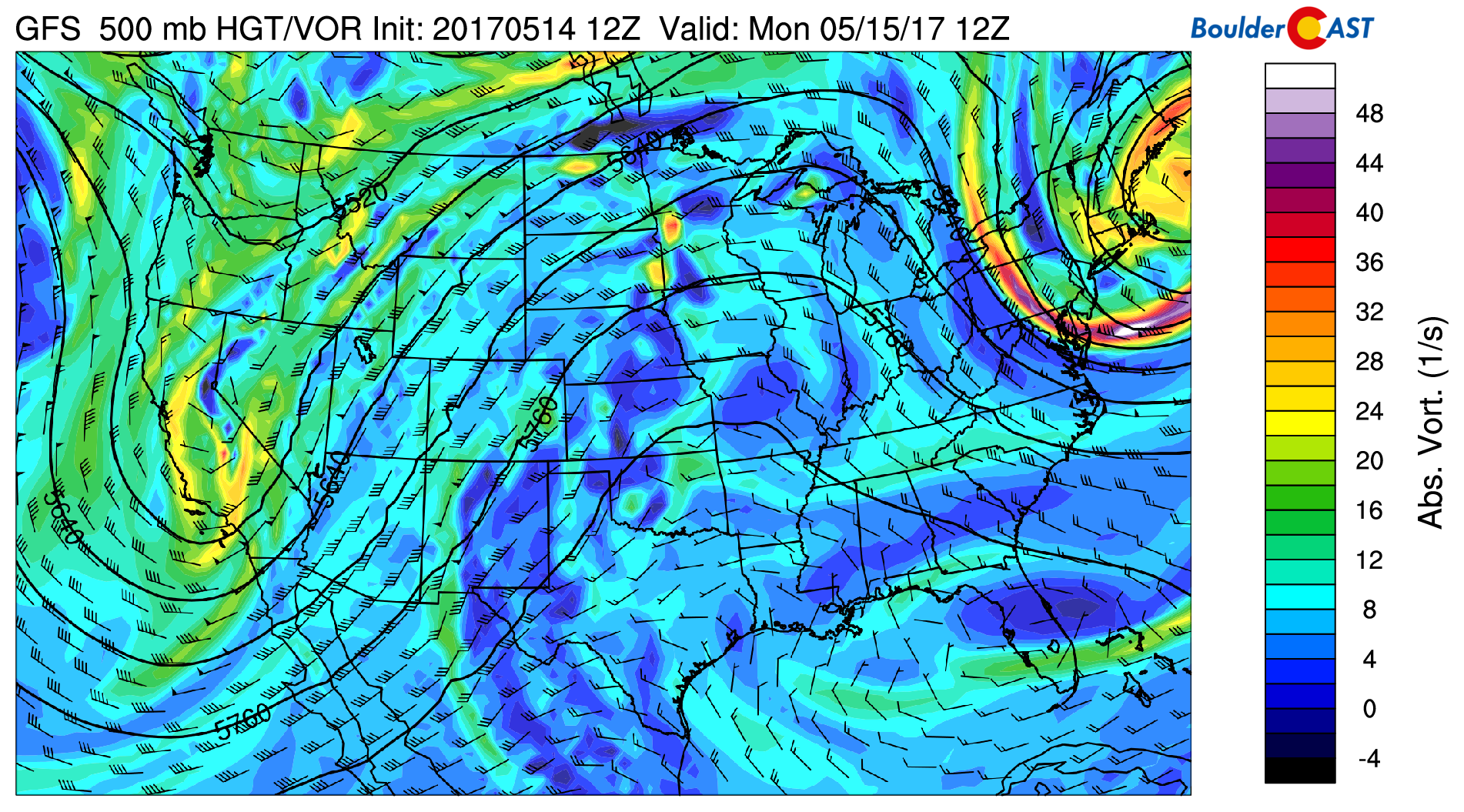
GFS 500 mb vorticity map for Monday morning. Southwest flow rules across Colorado.
You know the drill…this southwesterly flow pattern tends to feed moisture into Colorado which combines with daytime heating to produce afternoon thunderstorms. Notice that there isn’t much vorticity embedded in the southwest flow over Colorado or New Mexico (no patches of yellow). Without this added forcing, despite the elevated moisture, storms will be few and far between on Monday afternoon. The action will largely be confined to the higher elevations. Expect temperatures to reach into the low 80’s, our warmest day of the week.
Tuesday will see a higher chance of storms, but we still think most areas will remain dry. This increased chance is due to the trough (shown above over California) approaching and crossing Denver late Tuesday (shown below). Highs Tuesday will be cooler into the low 70’s.
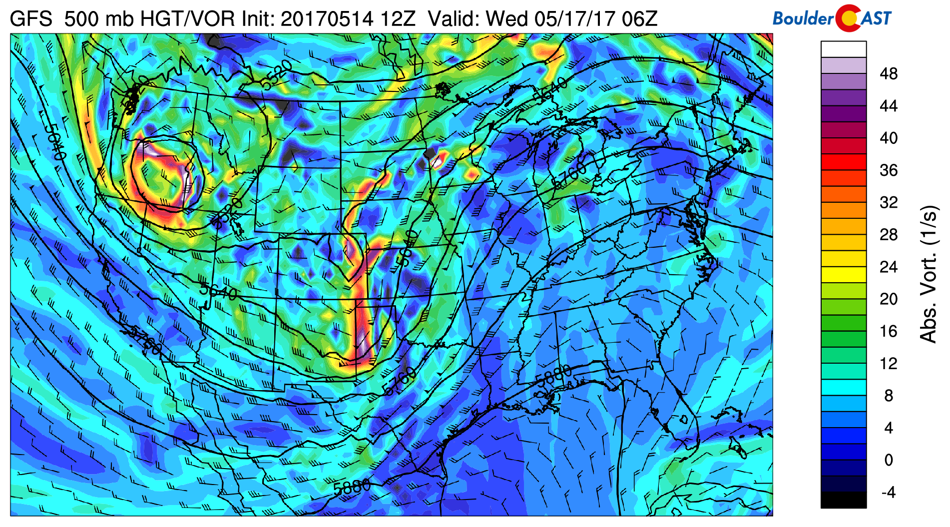
GFS 500 mb vorticity map for Tuesday night. A weak trough moves across Colorado, with our late-week storm churning across Oregon.
The storm to watch for late-week is seen in the map above spinning across Oregon. It’s definitely a strong one, and has very cold air on the southwest side of its core. The 700 mb map below shows temperatures around -20 degrees Celsius (below 0 F at 10,000 feet elevation)!
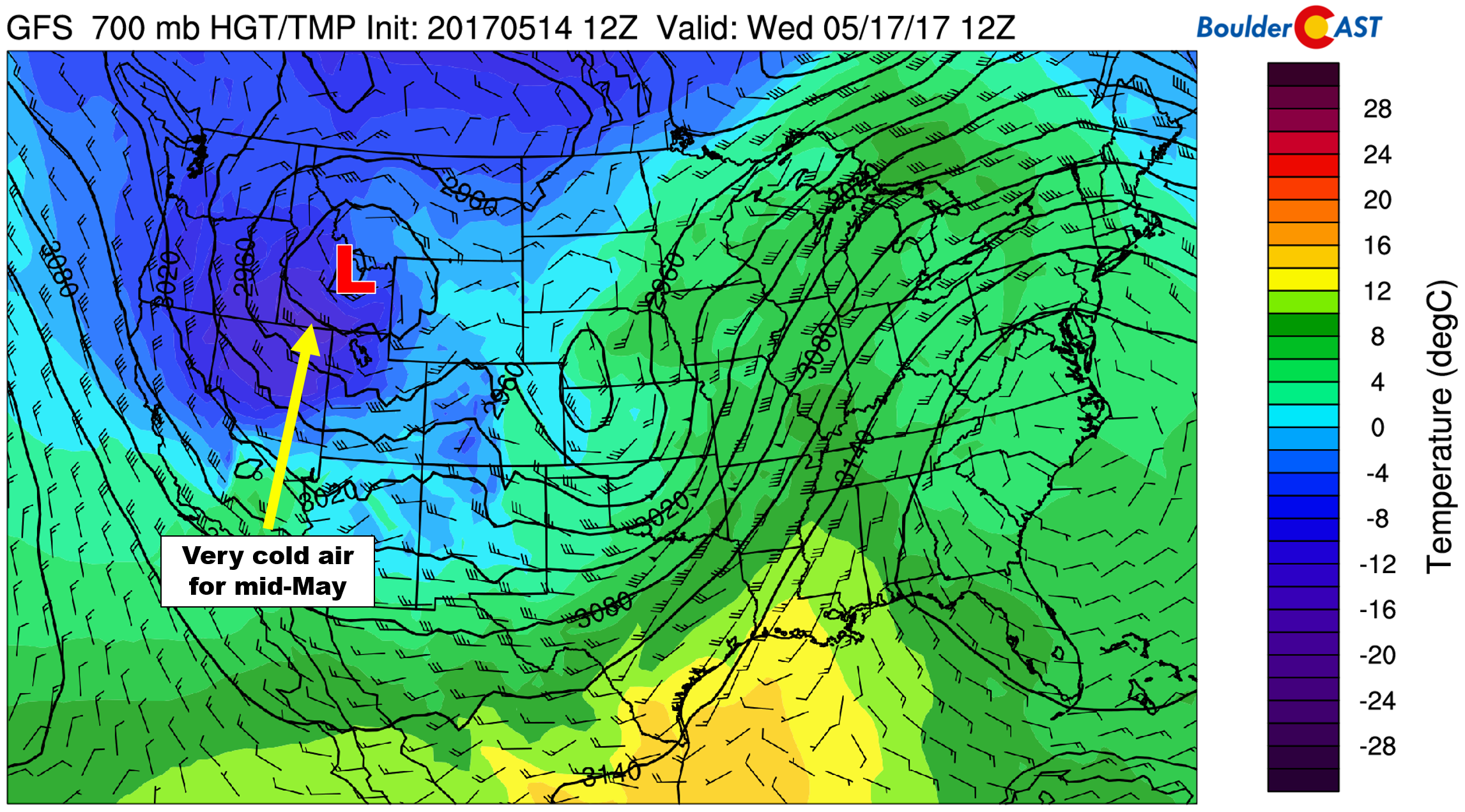
GFS 700 mb temperature map for Wednesday morning. Very cold air is evident in northern Nevada associated with the storm heading our way.
Of course this air’s temperature will moderate slightly as it approaches Colorado. Nonetheless, we’ll still be discussing snow for Thursday and Friday!
Wednesday will be a day of transition across the Front Range as the first trough moves away to our east, and the strong late-week storm gathers steam well to our west. There will actually be slight ridging across Colorado. Most indication as that a surface low will form in eastern Colorado late Wednesday night. Initially though, the bulk of the precipitation should remain to our north in Wyoming, so Wednesday could be mostly dry here. Expect highs in the mid 60’s with a mix of clouds and sun and slight chances of rain showers.
Another round of unsettled weather to end the week
Here we are, four days out, and the models of course don’t agree how things will play out for the messy weather that appears to be materializing late in the week. The strong upper-low mentioned above will reach the Colorado-Utah border or Four Corners region by Thursday morning . The GFS model keeps the storm relatively stationary in this spot until Friday morning. The Euro stalls the system even longer…into Saturday. We really find it hard to trust any of these solutions right now as they are changing wildly run-to-run of each model.
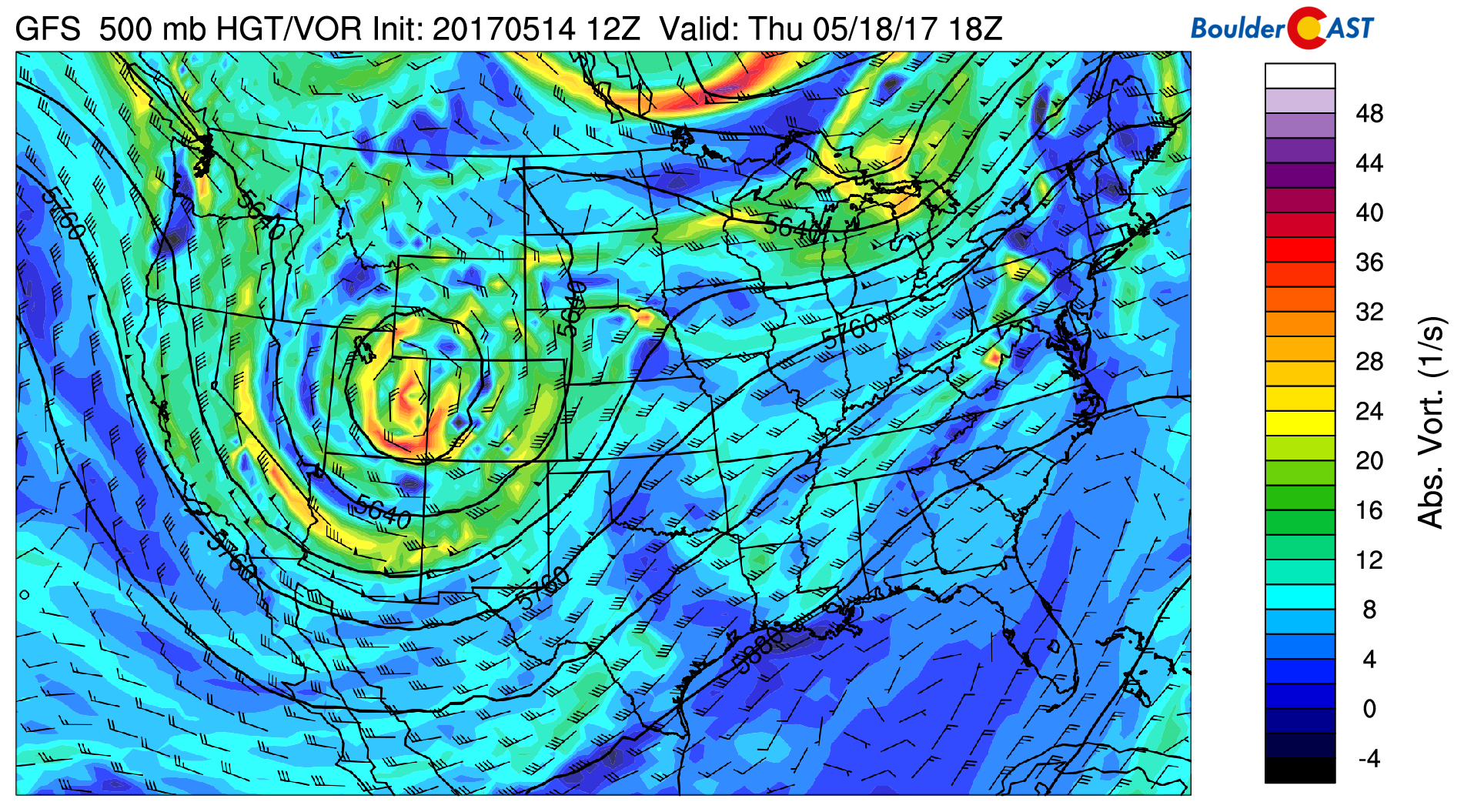
GFS 500 mb vorticity map for Thursday. The strong closed-low is centered over eastern Utah. This will put northeast Colorado in a great spot for widespread precipitation.
This timing will be critical as the storm’s position would be a favorable one to support upslope and (potentially significant) precipitation across the Front Range. Combined with the cold air we mentioned earlier, Thursday and Friday’s forecast is precarious at best. For example, the latest few runs of the GFS are producing several inches of snow across the Plains Thursday night into Friday morning, with significant snow accumulations in the Foothills (2 to 3 feet!). The Canadian model shows similar results, while the Euro is warmer and brings less precipitation. Widespread showers could begin as early as late Wednesday night and may linger into the Friday night, with 1″ or more of liquid possible.
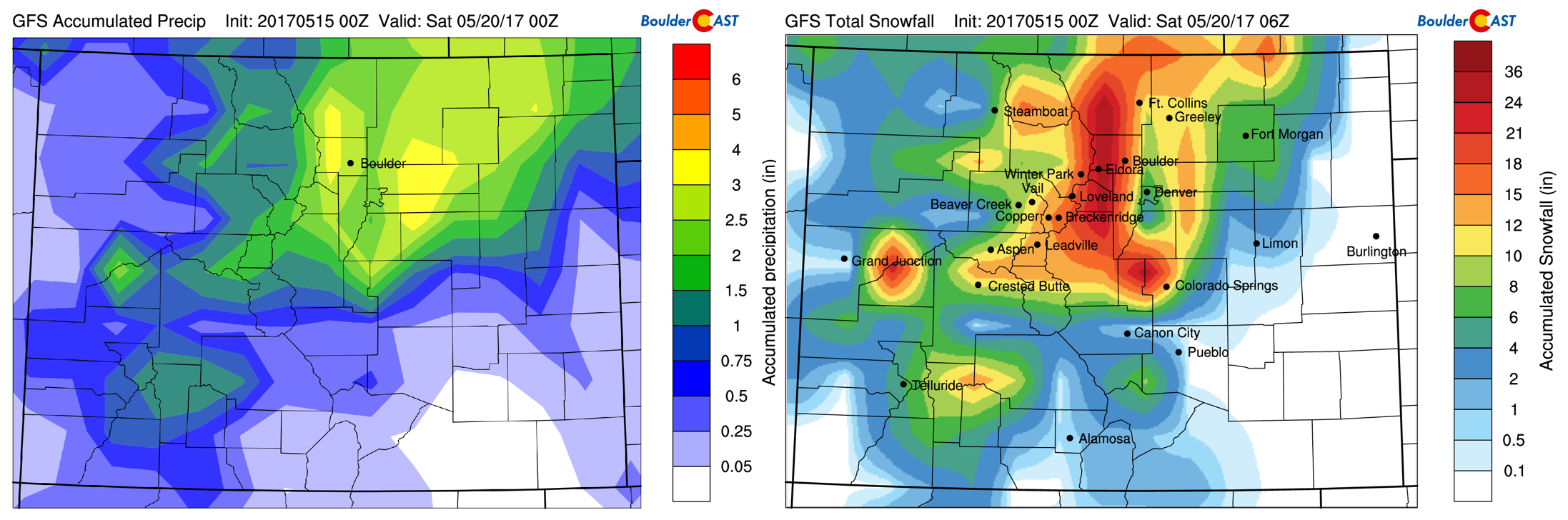
Latest GFS forecast for precipitation (left) and model-derived snowfall (right) this week.
We’re too skeptical of what the models are throwing at us right now to make any specific forecasts. For now, expect rather gloomy, cold and rainy weather Thursday and Friday, with the potential for even a few snowflakes late Thursday night. We’re only about one month from the summer solstice, so sun angle is a MAJOR hindrance to accumulation this time of year. We’ll need the coldest air and precipitation to overlap during the overnight hours for any snow to stick on the Plains. If you’re in the Foothills, confidence is growing for heavy snow during this time, especially above 8,000 feet. Highs both days will be well below normal (low 40’s to low 50’s on the Plains).
Stay tuned for updates as the week progresses.
Forecast Specifics:
Monday: Partly sunny skies with isolated afternoon and evening thunderstorms, mostly across the higher elevations. Highs near 80 on the Plains and in the mid 60’s in the Foothills.
Tuesday: Sunshine early, then increasing clouds with isolated afternoon and evening thunderstorms. Temperatures will be in the upper 60’s across the Plains and in the upper 50’s in the Foothills.
Wednesday: A mix of clouds and sun through the day. Isolated to scattered rain showers will be possible in the Foothills and Plains as the evening wears on and overnight. Highs in the mid 60’s for the Plains and low 50’s in the Foothills.
Thursday: Overcast with on and off showers through the day. Snow levels will be around 9,000 feet during the day, but fall overnight into Friday. Expect temperatures to top out in the upper 40’s across the Plains, with upper 30’s in the Foothills.
Friday: Overcast with rain/snow showers on the Plains and snow showers in the Foothills. Significant snow in the Foothills above 8,000 is looking likely. Accumulating snow on the Plains is not out of the question as well. Highs will be in the mid 40’s for the Plains, with low 30’s in the Foothills.
High Country: Isolated thunderstorms will be possible during the afternoon and evenings Monday and Tuesday. By Wednesday, cooler air moves in with the threat of spotty snow showers above 10,000 feet. Thursday and Friday will be very unsettled across the Mountains with significant snow accumulation likely both days.
Don’t be selfish…share our forecast with your friends!
Mon
Tue
Wed
Thu
Fri


Temperature
81
69
64
48
43


Precip Chc (Plains)
10%(pm)
20%(pm)
20%(pm)
60%
60%


