
This week’s weather begins cooler but seasonal with a chance of a rain/snow mix. Don’t worry though. Warmth returns later in the week with near 70-degree temperatures. Read on for more in-depth forecast discussion.
Unsettled and chilly
This past weekend has been quite nice, with 60’s on both Saturday and Sunday. Plenty of high-level clouds streamed in from the west each day, preventing temperatures from climbing into the 70’s. These high-level clouds were associated with a series of West Coast storm systems accompanied by a strong atmospheric river which continues to bring precipitation to California. We will discuss this later in the post, but things are finally looking up for them after a dry start to 2016.
For today, all eyes are on a weak shortwave pushing across Colorado into western Nebraska by this evening. Below shows the 500 mb absolute vorticity map for this afternoon. Of importance is a weak shortwave centered around central Colorado at this time period. This wave will provide needed snowfall in the High Country and will also lead to a light rain/snow mix over portions of the Denver Metro area this afternoon/evening.
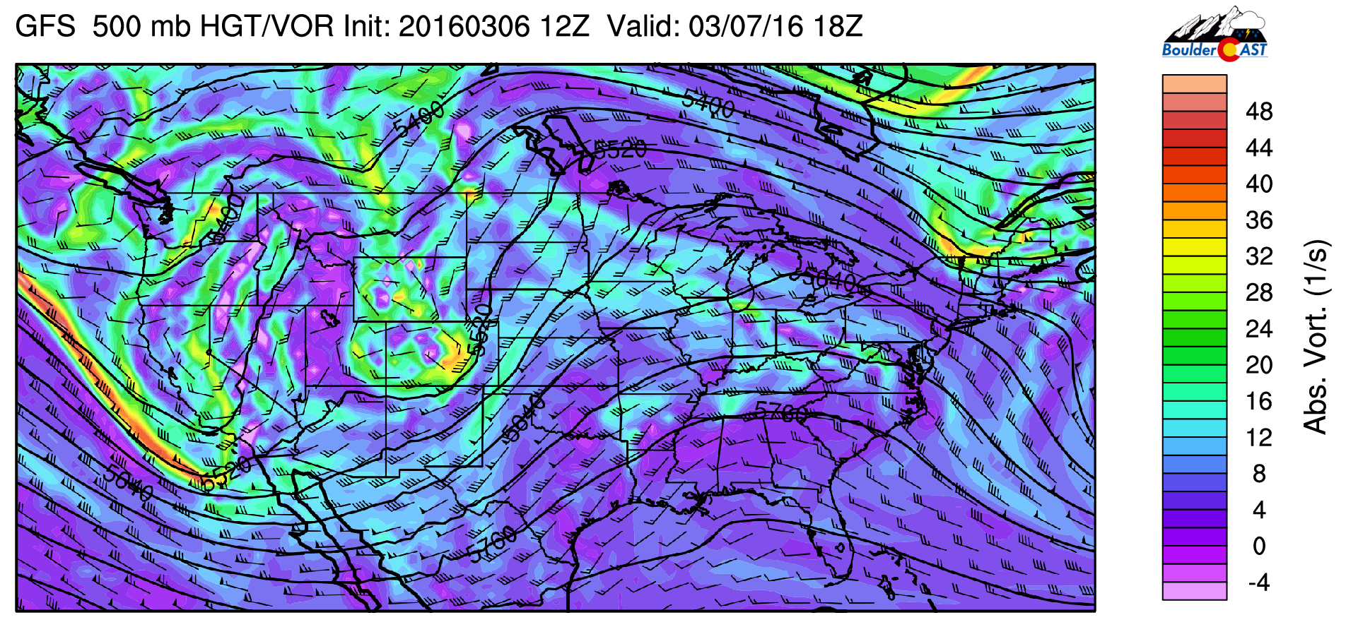
GFS 500 mb absolute vorticity for this afternoon
A secondary shortwave currently moving into southern California will be a player for snow in the Mountains tomorrow, with little impact for the Plains (see above).
Coupled with today’s shortwave is a developing lee trough, as can be seen in the NAM model forecast for this evening.

NAM 800 mb temperature, height, and wind barbs for this evening
A well-defined circulation tracks into far northeastern Colorado tonight. This track will favor west-northwesterly downslope flow for the Front Range. We believe that given this flow pattern, the chances of measurable precipitation will be quite low for the city of Boulder and nearby Plains. The best chance will exist in the Foothills and further east of I-25.
Also evident above are warm temperatures at 800 mb, which is just above the surface. Most of the temperatures near Denver will be above freezing, so it is likely any precipitation will be in the form of rain with light snow in the Foothills. This is also evident in the NAM precipitation type forecast, showing a sharp delineation of rain and snow right over Boulder. We won’t rule out some wet flakes mixing in.
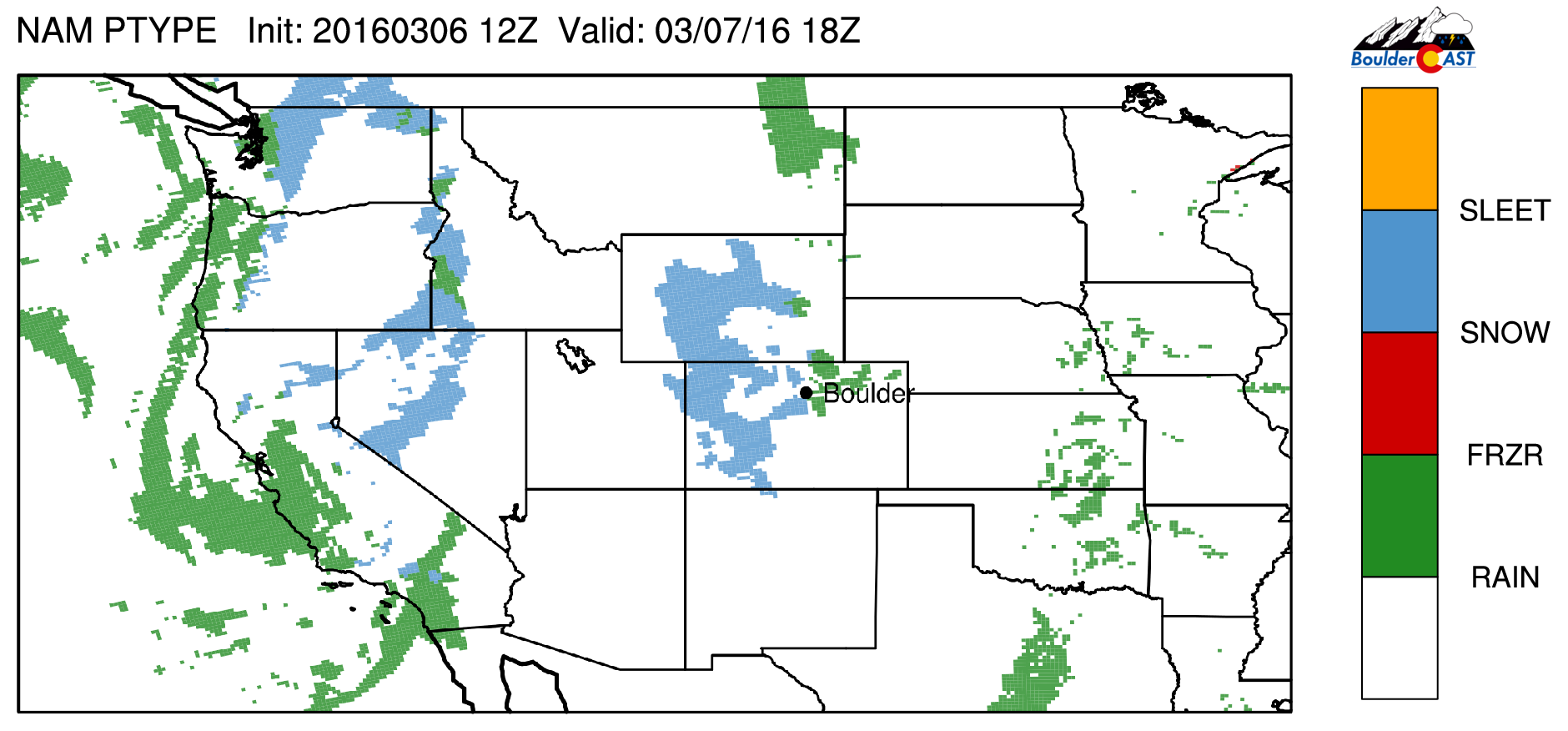
NAM precipitation type for this evening.
Model forecasted snowfall through tomorrow morning shows little to no accumulation in Boulder/Denver, as both the NAM and GFS depict a downslope signature. Again, the best chance will be in the Foothills. The GFS is showing a band over northeastern Colorado, though this is likely overdone as temperatures are above freezing in this location too. The Mountains look poised for 3-6 inches of snowfall and another light round for Tuesday alongside the second shortwave. Good ski conditions will exist Monday through Wednesday as a result!
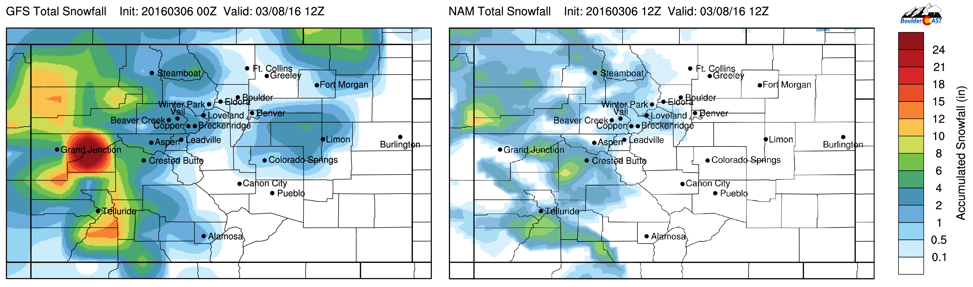
GFS (left) and NAM (total snowfall amounts ending tomorrow morning
The weak shortwave pushes out Tuesday, with another one at the helm! Below shows the GFS forecasted absolute vorticity. A large system is located in western Mexico, well to the south of Colorado!
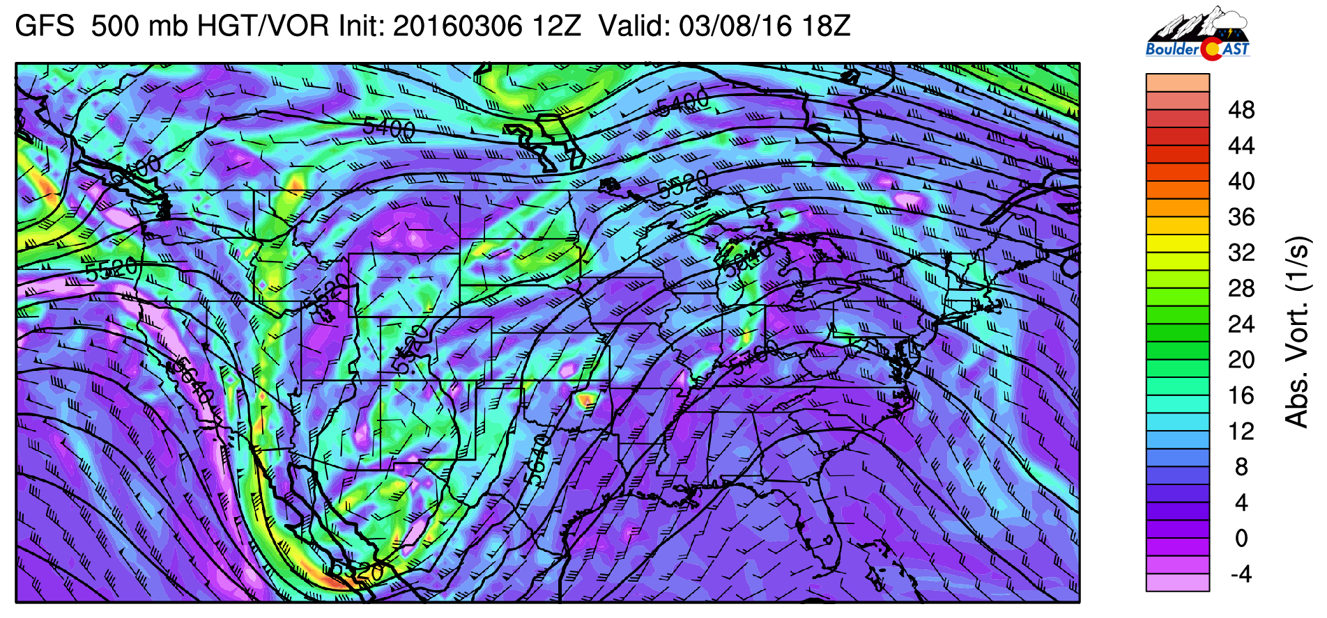
GFS 500 absolute vorticity for Tuesday
This storm location is extremely far south, and will keep the coldest air and best dynamics far from Colorado (enjoy the snow, Mexico). However, the southerly flow to the north of this system will help entrain moisture into the higher terrain with a few more inches of snowfall likely.
Over the Plains, expect mid to high level clouds around, especially in the evening, as depicted in the GEFS forecasted relative humidity at 700 mb below. Northeasterly upslope flow will keep highs cooler, in the upper 40’s over the Plains.
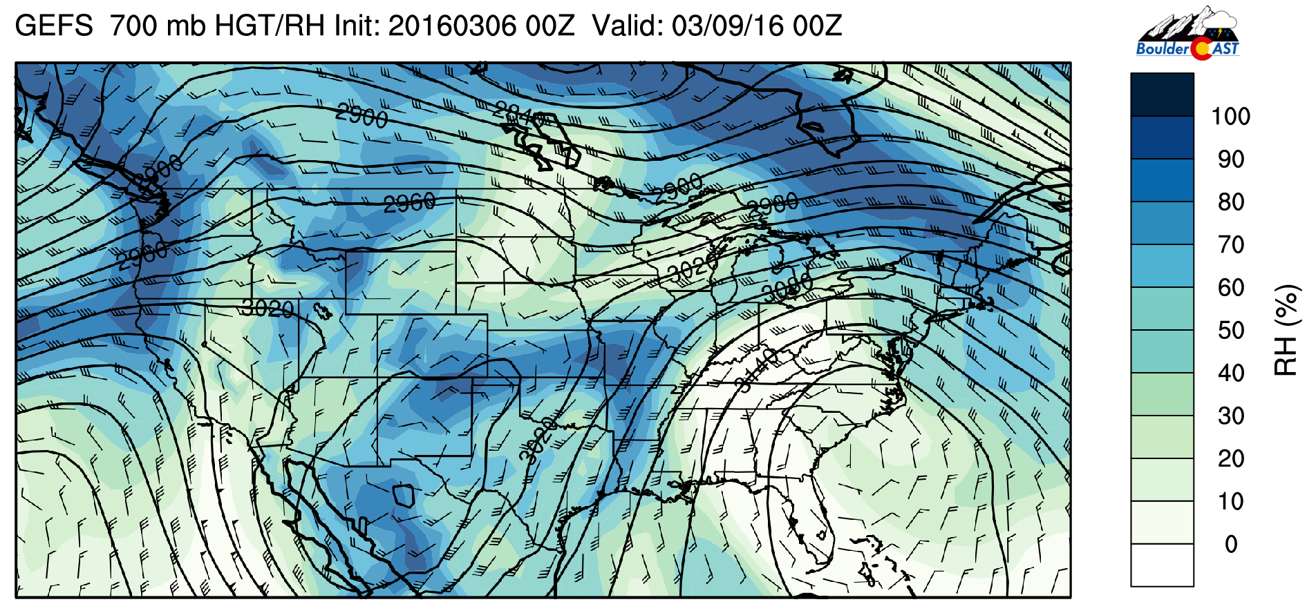
GEFS ensemble 700 mb relative humidity for Tuesday
Warmer times ahead
Wednesday there is a break in upper-level action, as we end up between two jet streams. As can be seen in the below upper-level wind forecast, Colorado is in between the polar jet, which is located to our north over Montana and into the Great Lakes, and north of the subtropical jet, which is over Mexico and Texas. This subtropical jet is also punching into California, bringing with it a series of atmospheric rivers and storms. Colorado, however, will be calm, with gradual warming from Wednesday into Friday and mostly sunny skies. Expect middle 50’s Wednesday and low 60’s Thursday.

GFS 250 mb upper-level winds and heights for Thursday
Friday looks to be our warmest day. Below shows the GFS forecasted surface temperature and mean sea-level pressure. It depicts a lee trough signature for downslope flow. In addition, 700 mb temperatures (not shown) are around 4 degrees Celsius, supporting high temperatures near 70 degrees. The GFS is forecasting highs in the low to middle 70’s for the Plains, with 60’s in the Foothills. Although this is a long way’s out, we believe the weather will be superb to end the week!
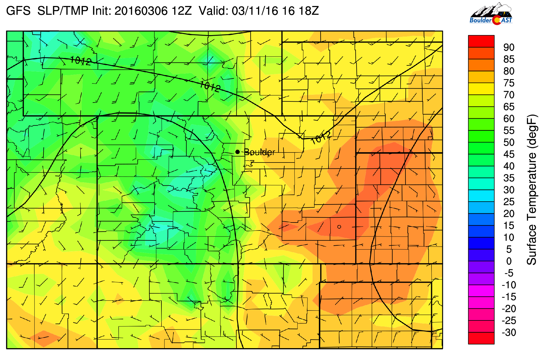
GFS surface temperature forecast for Friday
Now for California, big picture!
As mentioned earlier, the real story this week is a series of atmospheric rivers that will produce large amounts of precipitation (snow for the Sierras) over California. Some locations in the Bay Area have reported near 10″ of rain already.
Below shows the GFS accumulated precipitation through Friday afternoon.
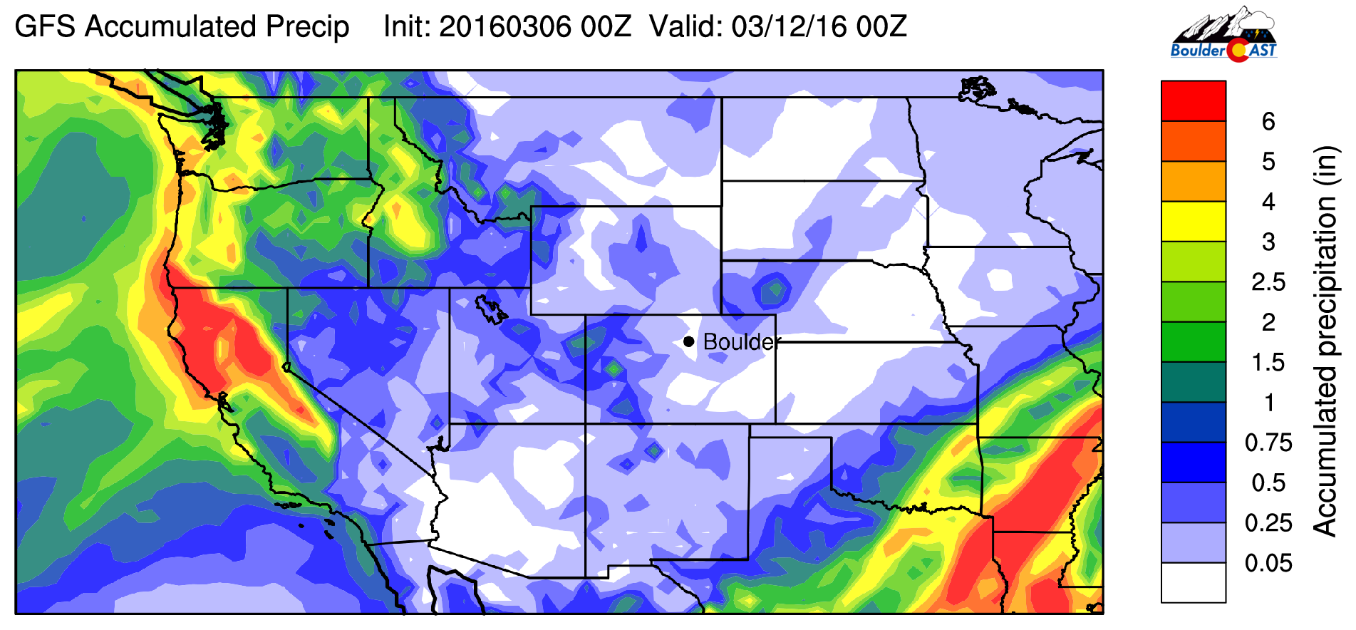
GFS accumulated precipitation through Friday
More than 6 inches of of additional rain is possible in California, with the Sierras likely seeing 3-4 feet of snow. This will be great for the state and their reservoirs. But unfortunately, southern California will not see much. Even with El Niño this year, they have remained fairly dry most of this winter, and that looks to continue for at least this week.
The Forecast:
Monday: Sunshine becoming mostly cloudy. Widely isolated light rain/snow showers in the afternoon and early evening. Highs in the middle 50’s over the Plains and middle 40’s in the Foothills. Little to no snow accumulation is expected.
Tuesday: Partly sunny skies with high clouds moving in late afternoon and evening. Highs cooler in the upper 40’s across the Plains and upper 30’s in the Foothills.
Wednesday: Some clouds in the morning giving way to afternoon sunshine. Highs slightly warmer in the middle 50’s over the Plains and middle 40’s in the Foothills.
Thursday: Gorgeous weather with highs in the lower 60’s under sunny skies, with lower 50’s in the Foothills.
Friday: Sunny and beautiful. Some high clouds possible in the afternoon, but well above average in the upper 60’s on the Plains and upper 50’s in the Foothills.
High Country: Look for light to moderate snow showers Monday and Tuesday with 4-8 inches of snowfall by Wednesday. This will result in good ski conditions for the first part of the week. Dry conditions take hold Wednesday through Friday, with a chance of snow returning next weekend.
Extended Outlook: Last week we were hopeful of an active pattern taking hold this week. That has not come fully to fruition, but we do see a cool down. Still, the long-range models continue to indicate that a more active pattern could take shape by the middle of March. We remain optimistic!
| Source | Mon | Tue | Wed | Thu | Fri |
|---|---|---|---|---|---|
| BoulderCAST | 52 | 50 | 53 | 61 | 69 |
| NWS | 52 | 51 | 57 | 64 | 69 |
| AccuWeather | 54 | 49 | 53 | 64 | 69 |
| The Weather Channel | 52 | 50 | 57 | 66 | 70 |
.Last week’s recap:
Here are the results of last week’s forecast. First, the forecasts and observations from all of the sources:
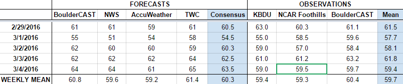
Last week we expected a relatively warm week with frequent weather systems passing and very low chances of precipitation. Each day last week was within about 2 degrees of 60. Talk about consistency. We had a chance of rain (higher elevation snow) in the forecast Monday. Boulder recorded 0.01″ on Monday, and also a very light trace on Wednesday.
Let’s look at the error analysis. Shown below is the amount of degrees (in Fahrenheit) that each source was off from the mean observed temperature for Boulder. Positive values indicate the forecast was warmer than what actually occurred, while negative values arise from a forecast that was cooler than what was observed.
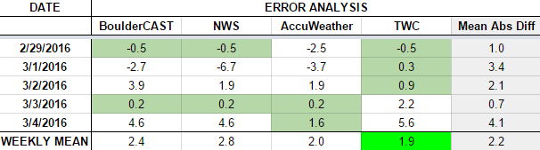
Definitely a better week for everyone than last time. Friday had the largest error, with cloud cover and winds keeping temperatures a bit lower than forecast (59 observed vs 64 forecast).
The bottom row of the error table shows the weekly mean error for each weather outlet, a good measure for who was the best and more consistent “forecaster” for the week. First place goes to The Weather Channel with 1.9 degrees of error. BoulderCAST had the best forecast two days during the week, but came in third overall.


