Two potent storms will impact the state of Colorado this week. Both are poised to bring the chance of significant precipitation to the region, including the threat of heavy spring snow at times. Read on as we cover the details of this week in Front Range weather.
Rainy recap from the end of last week
Last week’s rain/snow event fell exactly one month after our most recent one in late February. In between the two, four weeks of dry weather, worsening drought, and sporadic wildfires.
We had been tracking the system for many days leading up to its arrival last Thursday. All along, the models were lacking cold air, so our suspicions were that it could be a mostly rain event for the Plains. However, in the final 36 hours, the models started to do some strange things. They began to not only show more cold air, but also significant variations in track from run-to-run. When this happens, our confidence in the forecast shrinks substantially. No one model or blend can be trusted, and nailing the correct forecast comes down to forecaster experience and a good deal of luck. We hope we stressed this uncertainty enough to you.
Our team issued our final forecast early Thursday morning, more than 12 hours before the precipitation started. Our biggest concerns were that the track of the surface low could be too far south and east (lowering precip totals overall), and also that if the change-over to snow did happen, some areas could get slammed! We went with 0 to 3″ for the Plains. There was just too much uncertainty for us to go any higher. The National Weather Service waited until the final hours, right before the precipitation commenced, to issue a Winter Weather Advisory for the entire area. They predicted 3 to 6″ of snow, with 4-10″ in the Foothills. This was obviously much higher than our forecast, and to their credit, the high-resolution short-range models were coming in snowier than ever right at the onset of the precipitation!
Shown below is our original forecast map created early Thursday morning. The observed storm totals per location are contained in boxes. Green ones indicate that the observed snowfall was within one inch of the given forecast range, while red was outside the scope of our forecast.
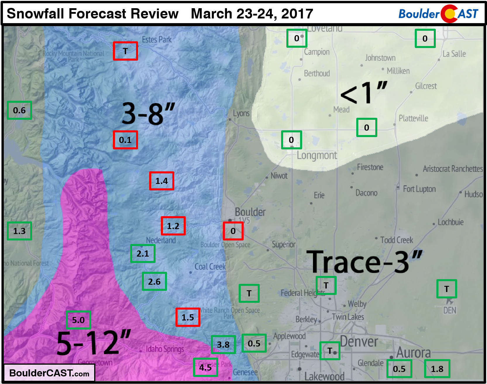
Overall, snow totals were in the bottom extent of our forecast ranges, or in some cases below. The Foothills generally got 1-4″ and the Plains 0-2″. A lot of these “tiny totals” can be blamed on temperatures remaining too warm to support snow, but also the track of the low being too far southeast.
This storm was disappointing on many fronts… It had the potential to put a decent dent in the current drought for everyone. As you can see from the precipitation totals below, it did for Denver and areas to the south, but definitely not for Boulder County.
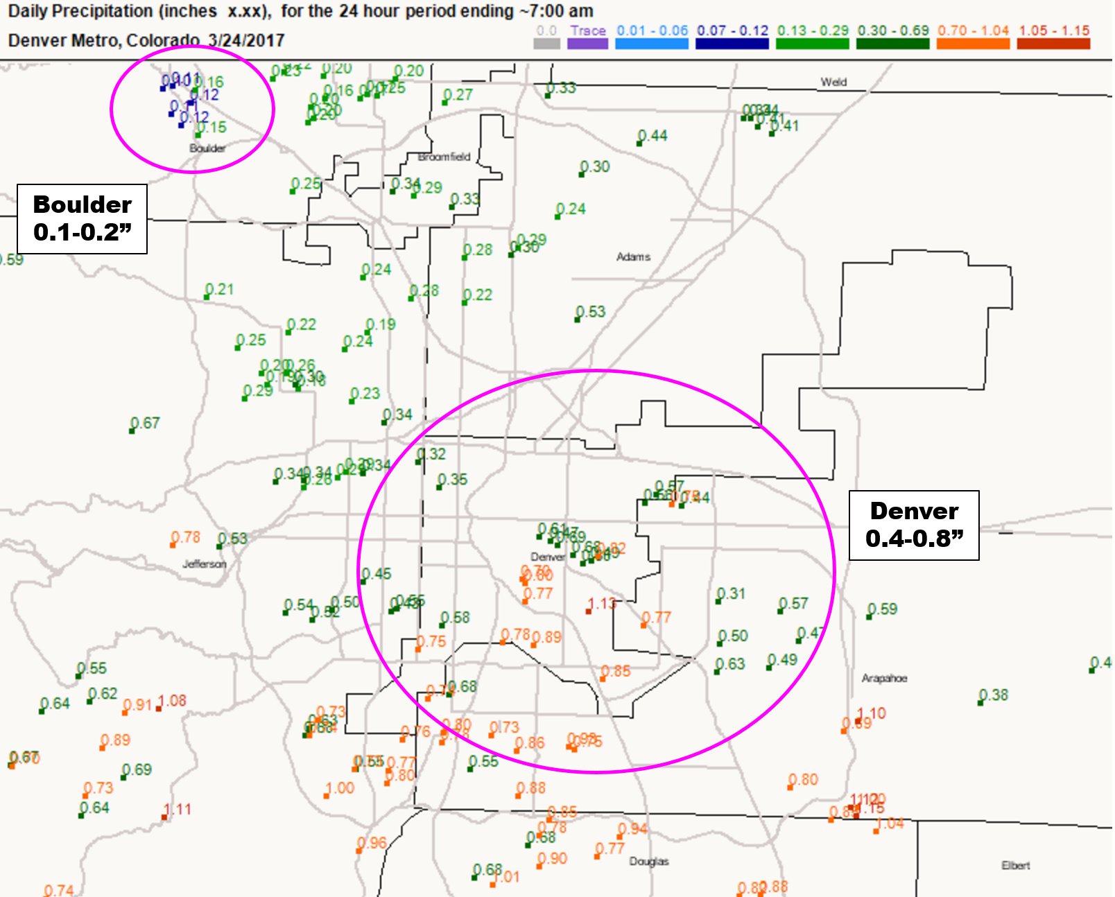
24-hour precip ending 7AM Friday (CoCoRaHS)
Fortunately, the pattern will remain busy through the upcoming week. We’ll have several more chances of precipitation to make up for last week’s under-producer.
An active pattern awaits!
This week we’re tracking two systems that are set to impact Colorado, both of which should bring an excellent chance of precipitation to areas both west and east of the Continental Divide. The animated loop of 500 mb height and anomaly for the week ahead is shown below. From this high-level look, the two inbound disturbances take-on a near-identical track and appearance. One arrives in the Tuesday/Wednesday time-frame. The second comes later for Friday/Saturday.
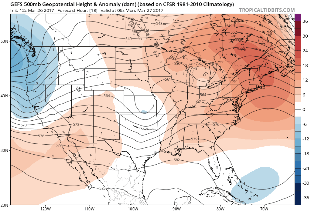
GEFS ensemble median 500 mb height and anomaly animated loop through Friday. This weeks storms are visible (blue areas).
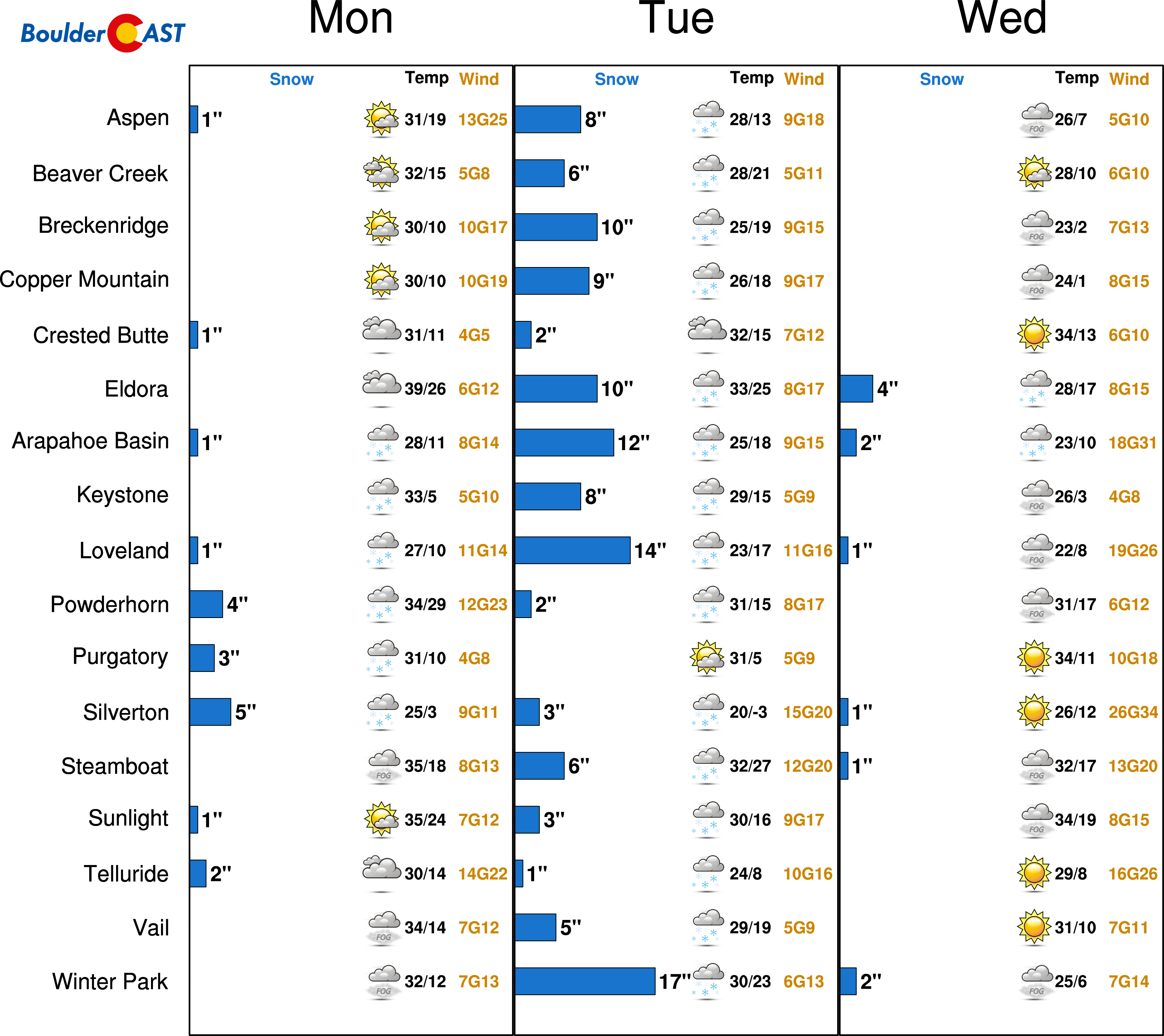
The meteogram image below shows that both storms could pack a very big punch for the Front Range…
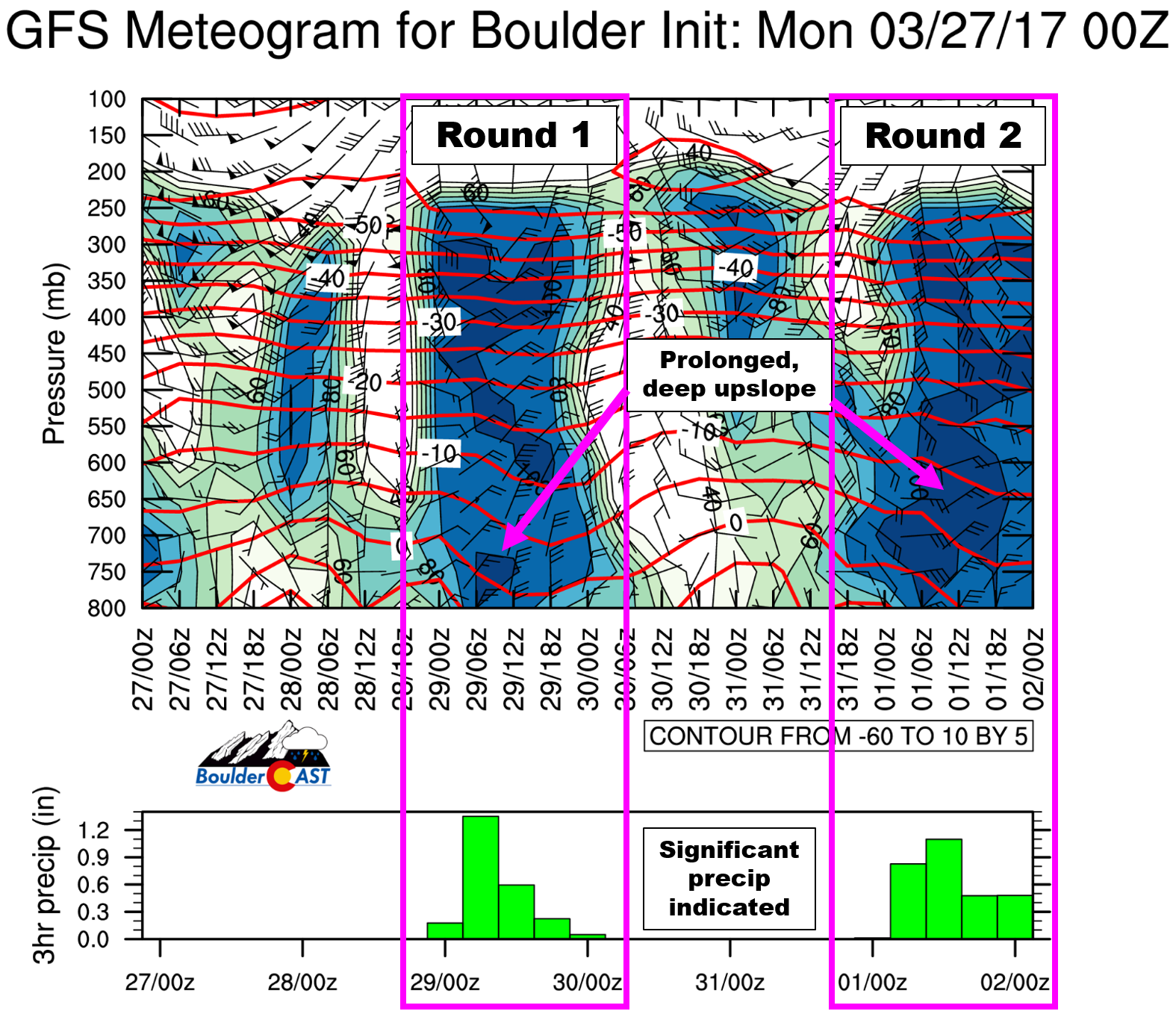
Round 1:
After a sunny and seasonal day Monday with a high near 60 degrees, the precipitation chances increase and temperatures decrease for Tuesday as the first system arrives. It will begin warm, with snow levels around 9,000 feet Tuesday during the day, lowering to around 6,000 feet by Wednesday morning. All in all, this system bears scary similarity with last week’s rain/snow storm. It will also have a slight chance to support snow on the Plains after midnight Tuesday night, but once again, the track being too far south is a concern.
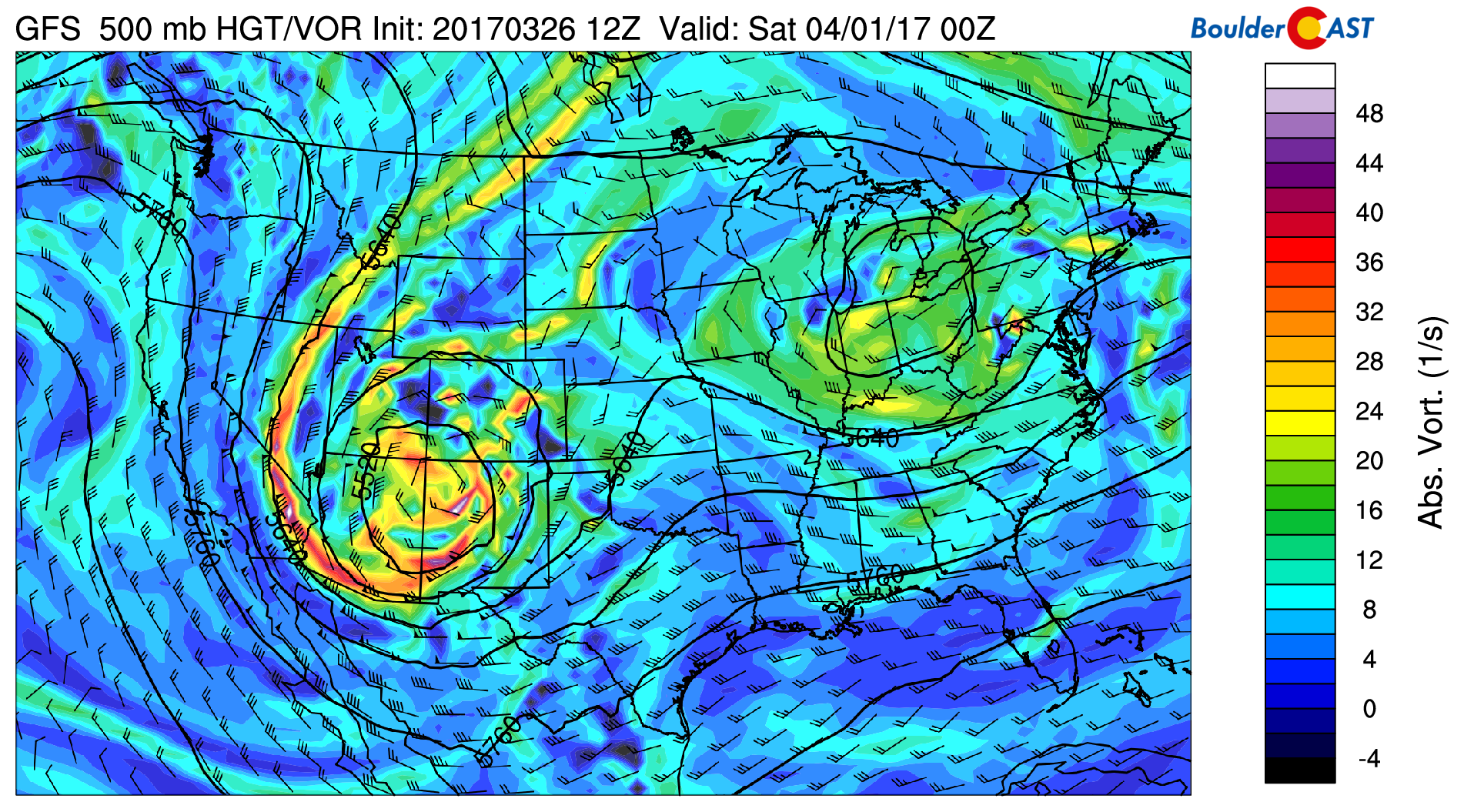
The 500 mb vorticity map below shows the position of the closed upper-low Tuesday night at midnight across the Colorado/New Mexico border. It has a very similar look and feel to the storm last week.
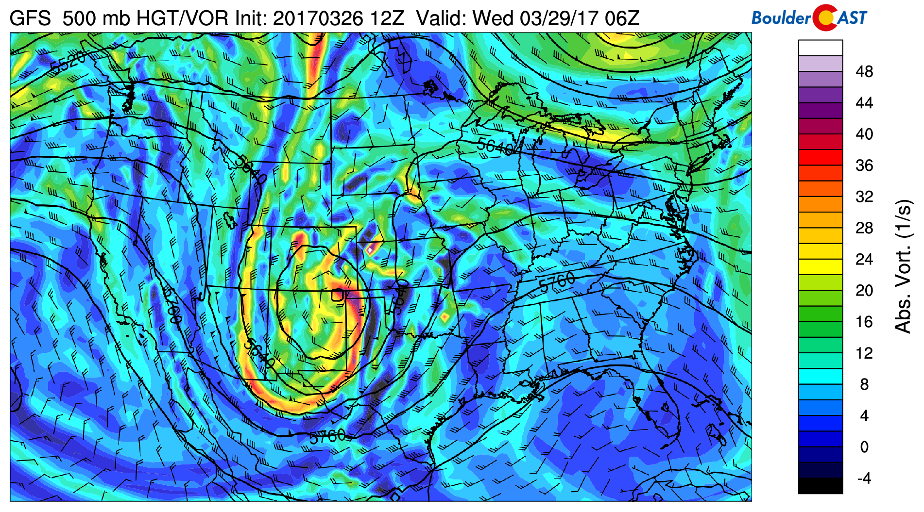
GFS 500 mb vorticity map for 12AM Wednesday showing the position of the storm to our south.
Precipitation chances will last through the day Tuesday, Tuesday night, and Wednesday for the Front Range. The best chance though will be Tuesday evening into Wednesday morning. Models are currently averaging around 1″ of liquid for both Denver and Boulder from the event! The GFS is the wettest of all models right now. Its ensemble mean (shown below; thick black line) is running closer to 1.5″ for Denver and even higher in Boulder.
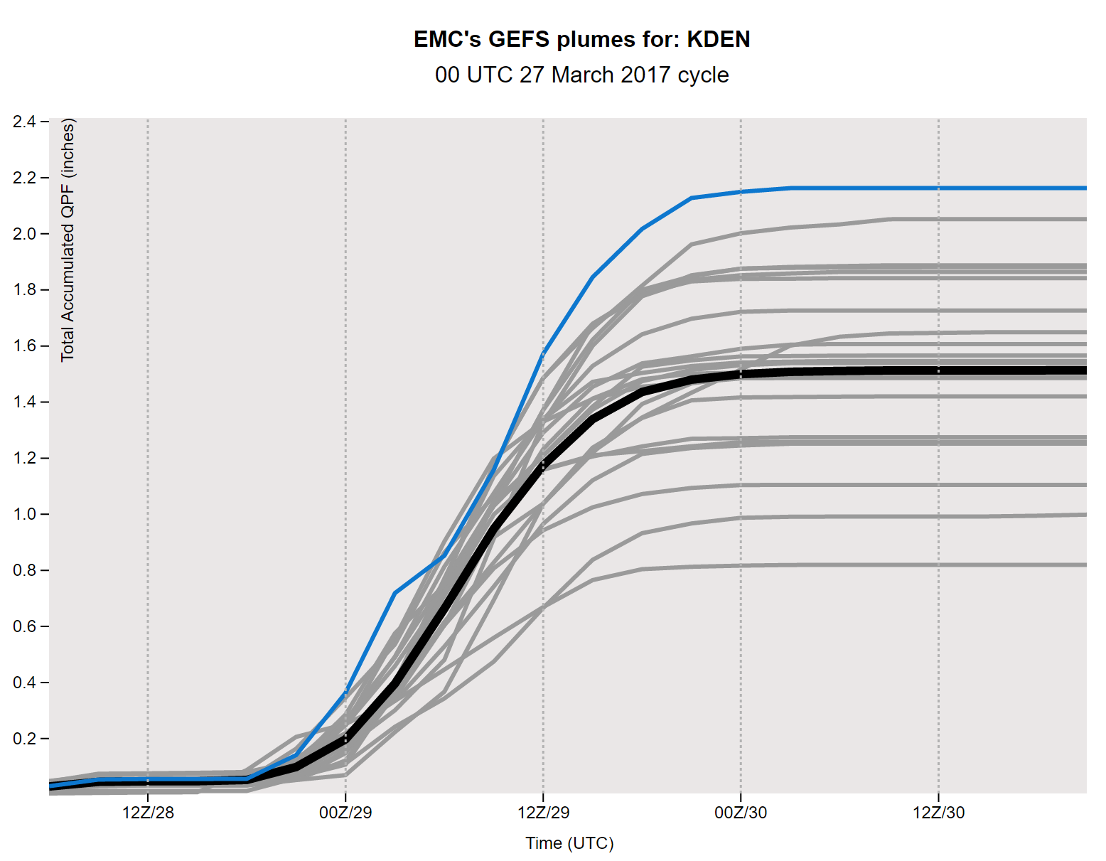
GEFS accumulated precipitation through Wednesday in Denver. More than 1″ of liquid may be possible from Round 1.
Right now the potential for “significant snow” looks plausible above 9,000 feet, minimal above 7,500 feet, and unlikely below 7,000 feet. Tuesday night and the first half of Wednesday are the time periods to watch for spring snow. With such a shocking likeness to last week’s storm, we expect things to play out similarly, with mostly rain on the Plains, the Foothills get a bit of snow, and the Palmer Divide piling up 6-12″ again.
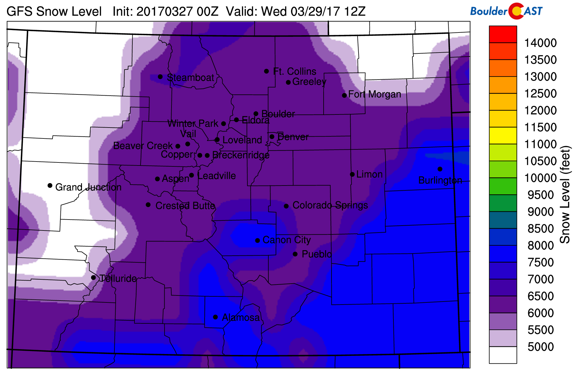
GFS-derived snow level for 6AM Wednesday morning. Around 6,000 feet is indicated across the Denver Metro Area. Dynamic cooling could push snow levels even lower.
There is still a little too much uncertainty to pin down specifics, especially regarding timing and snow levels Tuesday night. Check back tomorrow as we may need to provide an update.
Highs Tuesday will be in the low 50’s, with mid to upper 40’s on Wednesday for the lower elevations.
Round 2:
As the first system pulls away Wednesday night, a small ridge will work through the state on Thursday. This will bring warmer temperatures and mostly sunny skies. The second feature is projected to enter to Four Corners region Thursday night before slowly sliding across Colorado on Friday and Saturday. The 500 mb map below shows the storm taking a slightly more southern track than the first storm.
GFS 500 mb vorticity map for 6PM Friday showing the storm centered across the Four Corners.
We also caution that this storm is MANY days away so things are far less certain. Despite this, here are a few things we are interested in right now:
- Models have the storm slowly sliding across the state. This could provide an extended period of favorable conditions for precipitation across the Front Range, beginning Friday and lingering possibly into Sunday
- This second storm is deeper and colder than the first. Models are showing air cold enough to potentially support snow on the Plains.
- The track is already a little bit too far south. We’d hope to see this move back northward over the next few days to get truly excited.
With the storm arriving Friday, we’ll expect a chance of precipitation and increasing clouds through the day. Things could definitely get interesting Friday night and into the upcoming weekend!
Check back through the week for updates!
Forecast Specifics:
Monday: Sunny in the morning with increasing afternoon clouds and a slight chance of an evening rain shower. Look for a high near 60 degrees on the Plains and in the upper 40’s in the Foothills.
Tuesday: Mostly cloudy with rain showers that will become more widespread by late afternoon and evening. Snow levels begin high around 9,000 feet, but fall overnight into Wednesday morning towards 6,000 feet. Accumulating snow is likely above 7,500 feet…amount TBD. Expect afternoon temperatures in the low 50’s on the Plains and in the low 40’s in the Foothills.
Wednesday: Morning rain/snow showers are likely, but will decrease through the late morning hours. Overcast skies will remain for the rest of the day. Highs will be chilly on the Plains in the upper 40’s, and in the mid 30’s in the Foothills.
Thursday: Mostly sunny early with increasing clouds through the afternoon. It will be a dry day with temperatures rebounding back towards 60 degrees on the Plains and into the upper 40’s in the Foothills.
Friday: Partly sunny in the morning with clouds and precipitation possible during the afternoon and evening. Snow levels should be lower for this event, so a mix of rain and snow can be expected for now. Time will tell who gets what. Cooler with highs in the mid 40’s for the Plains and mid 30’s in the Foothills.
High Country: Snow will spread into the High Country Monday night and linger into late Tuesday night. Round 1 should produce 6-12″ of snow for the resorts. Round 2 arrives Friday and will persist into the upcoming weekend. Expect at least a chance of snow in the Mountains during this time, but the track is more favorable for precipitation east of the Continental Divide than west.
Extended: Ensemble models show things continuing to remain active next week as well. Look for the southern storm track to continue to deliver good chances of preciptation for the Mountains and Plains.
Mon
Tue
Wed
Thu
Fri


Temperature
61
53
47
59
45


Precip Chc (Plains)
10%(pm)
40%(pm)
60%(am)
0%
30%


