Happy First Day of Spring! As smoke spewed from the mouth of Sunshine Canyon yesterday, the extent of the wildfire threat become more obvious than ever. The fire ignited late Saturday night following what has been more than three weeks in Boulder without measurable precipitation. We have some good news…the week ahead should offer some reprieve for the extremely dry weather of late. In fact, we have a chance of precipitation in the forecast each and every day this week. We’re also tracking a potential spring storm late in the week. Continue reading for our complete weekly outlook including our thoughts on the potential for accumulating snow.
Mostly dry and warm through Wednesday
We begin the week under west-southwesterly flow as a broad ridge remains in place across the Mountain West at 500 mb (see below). This will keep things relatively quiet and warm through the first half of the week.
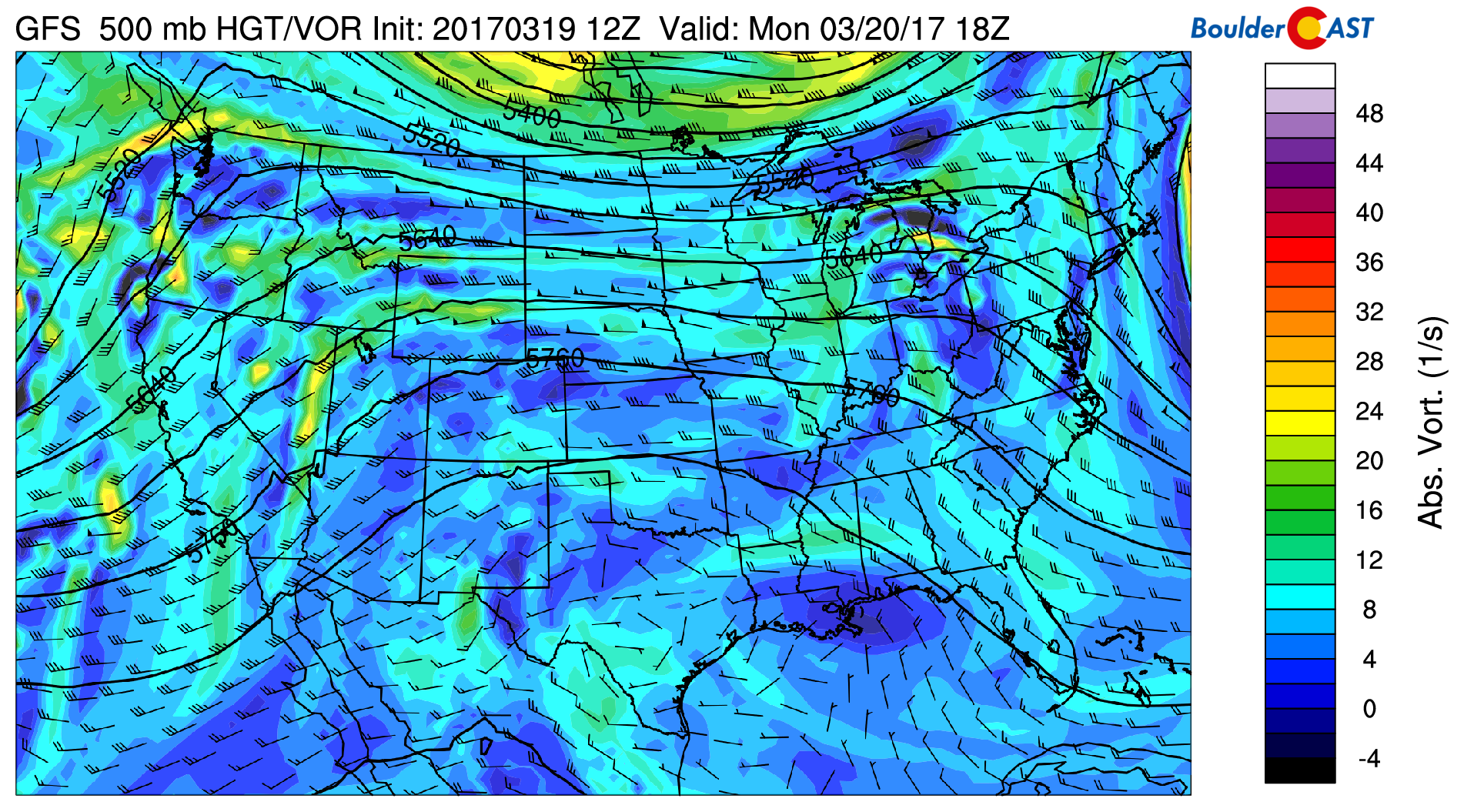
GFS 500 mb vorticity map for Monday, showing a large ridge in place across Colorado and the center of the USA.
However, note that there are a few pieces of energy embedded in the flow heading towards Colorado (yellow patches). In the map above, one is over Nevada and another off the coast of Los Angeles. These small disturbances will have just enough forcing and moisture to bring a slight chance of precipitation to the Mountains and Plains.
The first wave will move through Monday evening and night. Isolated showers will be possible across northern Colorado. Action looks to see slight enhancement on Tuesday as the secondary more potent energy moves through. We could see widely scattered afternoon and evening showers, and even a few thunderstorms across the Front Range. Snow levels will be higher Monday evening (10,500+ feet) than Tuesday evening (~9,000 feet). So unless your in the highest Foothills or Mountains, expect the precipitation to fall in the form of rain.
Monday’s high will be approaching 80 degrees once again with temperatures dropping possibly into the low 60’s for Tuesday behind a backdoor cold front. We’re not 100% sold on this front making it into Boulder/Denver on Tuesday. The 800 mb temperature map below shows the frontal boundary more-or-less stalled just east of Denver. In the winter-time, cold air tends to push further than the models show, whereas in the summer it is the opposite. This time of year, though, it’s a tough call. With this uncertainty, highs could remain in the upper 50’s or push towards 70 on Tuesday. Western and southern parts of the Metro area would stand a better chance at warmer temps.
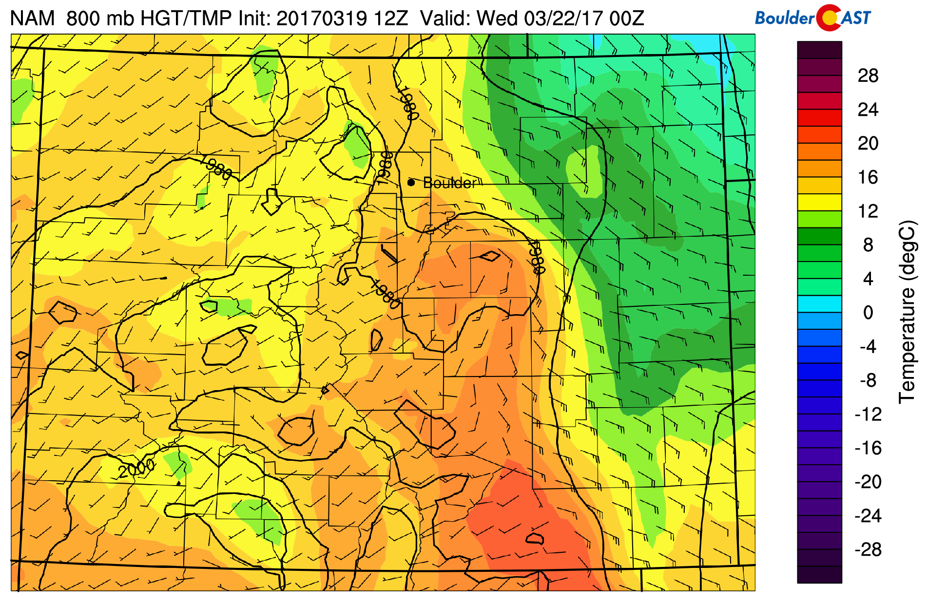
NAM 800 mb temperature and wind map for Tuesday evening, showing the cold front may not make it in Denver/Boulder.
By Wednesday, southwesterly flow and moisture begin to increase to Colorado ahead of our first real system in weeks! In the 500 mb map below, the feature we’re tracking is seen off the coast of southern California. However, a solid ridge is still in place across Denver. We’ll squeak out one more nice day Wednesday before things go downhill Thursday evening! Temperatures should rebound back to near 70 degrees under this ridge.
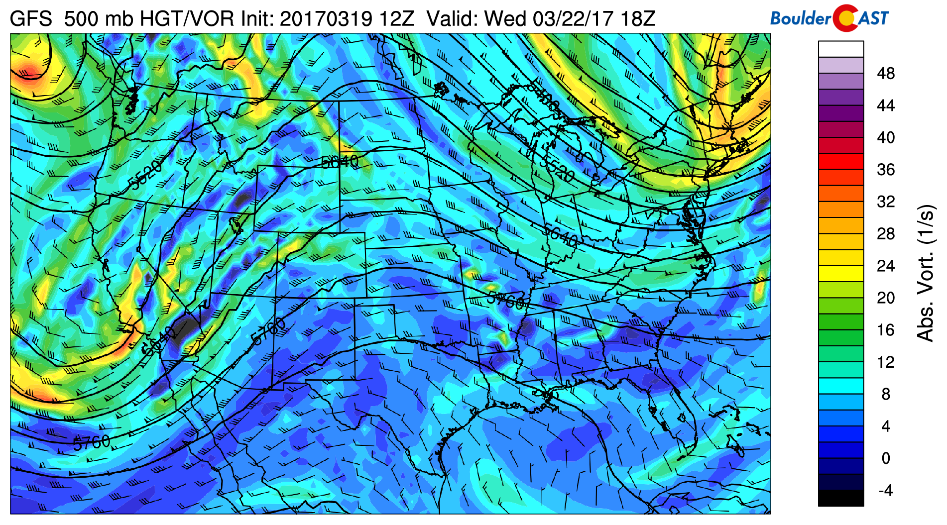
Wednesday’s 500 mb vorticity map from the GFS. Shown is a ridge just to our east, and our “spring storm” system coming ashore in California.
Looking good for precipitation to end the week!
By late Wednesday the trough will be ashore and eventually move into Colorado Thursday night. Models have been somewhat consistent with this storm’s intensity and track for many days now. Though questions remain, it looks like the Mountains, Foothills, and Plains will be in store for widespread precipitation Thursday evening into Friday morning. It’s a little too far out to comment on specifics, but here are a few things that are getting us mildly excited about the weather for once!
TRACK: The storm’s track remains consistent between several models (though they don’t all agree on the strength). The track currently is near-perfect for a classic upslope precipitation event for the Denver Metro area. The 500 mb map below shows the trough digging right across southern Colorado.
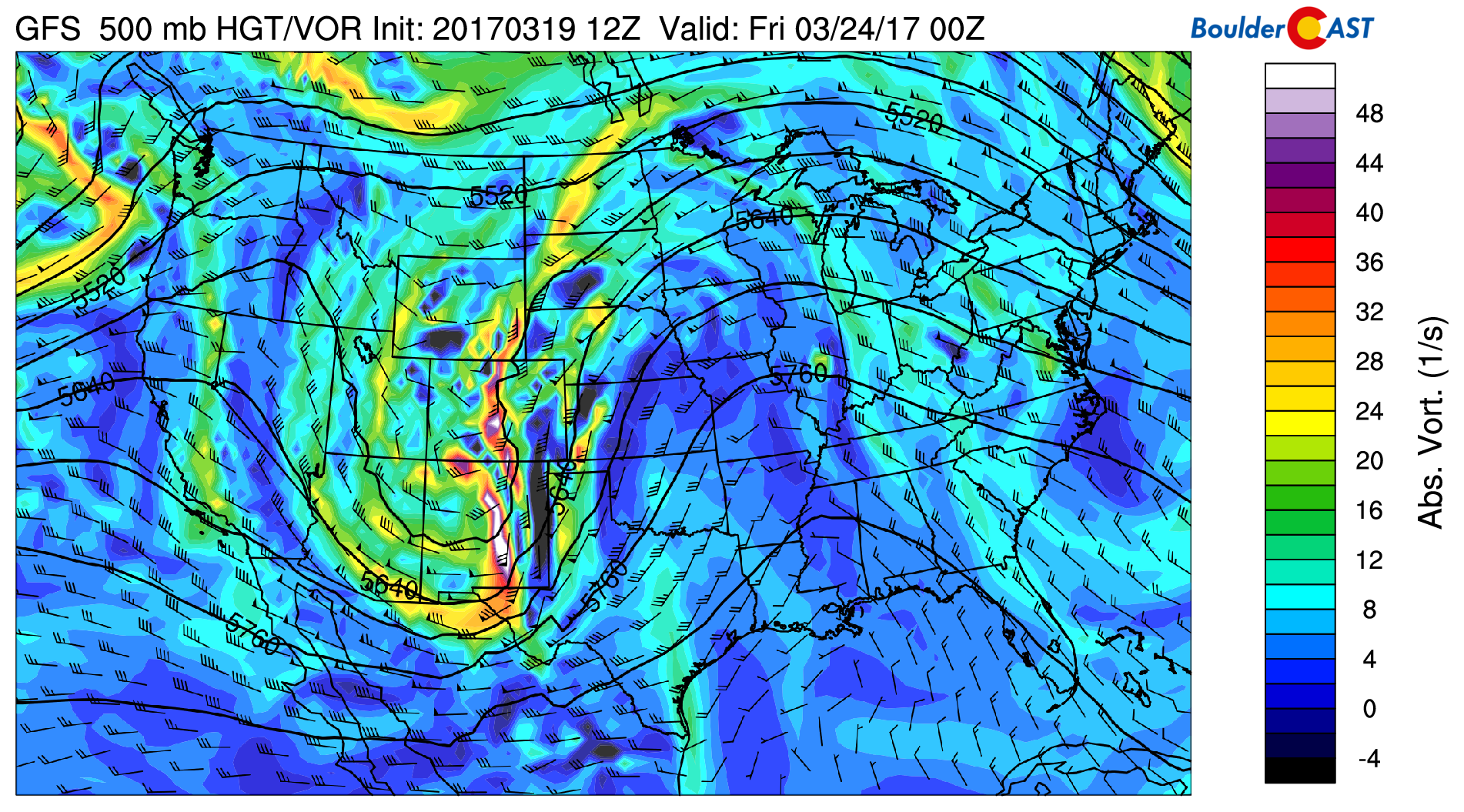
GFS 500 mb vorticity map for Thursday evening showing the system tracking across Colorado
TEMPERATURES: While models waver on the amount of cold air that will filter in along with this system, most do show the precipitation at some point changing from rain to snow (or at least mixing with snow) on the Plains. The latest GFS run has snow levels dropping from around 10,000 feet Thursday afternoon to around 6,000 feet by sunrise Friday (figure below). The overnight timing of the precipitation would favor lower snow levels and less melting under the that potent mid-March sun.
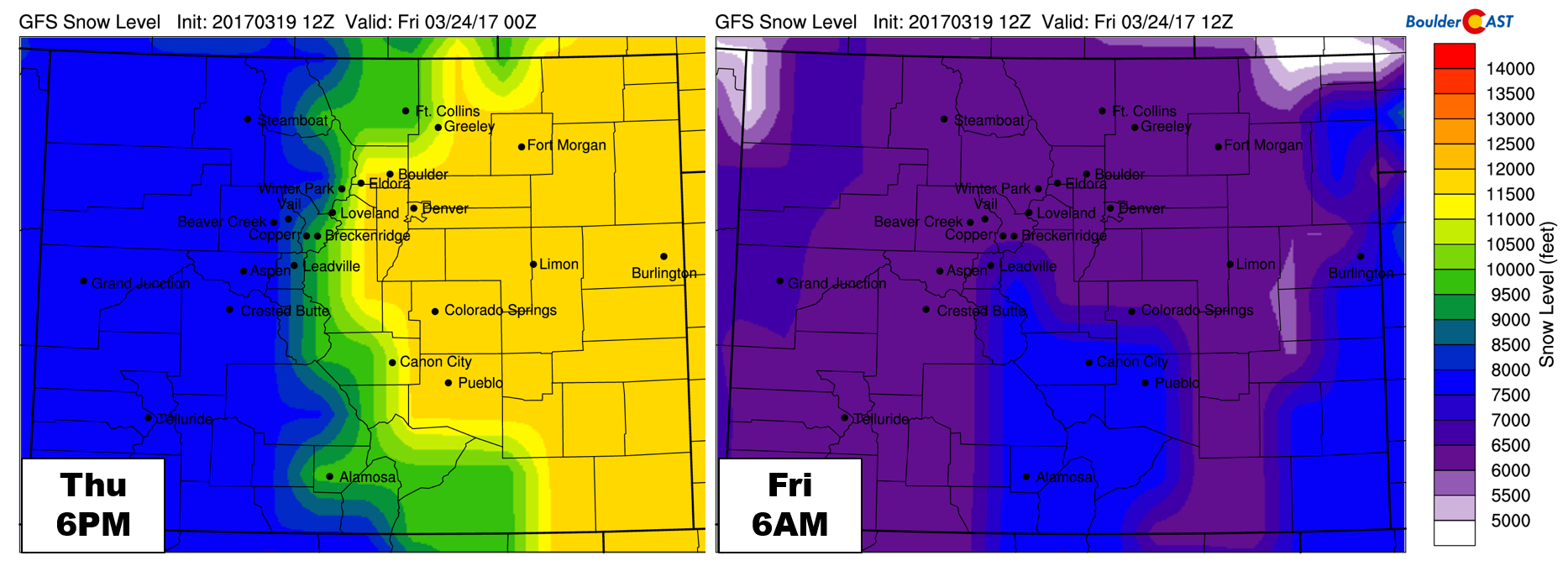
GFS-derived forecast snow levels for Thursday evening (left) and Friday morning (right).
We’ll continue to track this system through the week and provide inevitable updates when appropriate. For now, expect some precipitation to end the week with cooler weather for Thursday and Friday. Stay tuned! And if you haven’t done so already, please spend a moment taking our 2017 BoulderCAST Survey. Thank you!
Forecast Specifics:
Monday: Mostly cloudy and warm with a chance of isolated evening showers that could linger into late Monday night. Most areas will be dry however. Wind gusts in and near the Foothills could exceed 30 mph making for yet another Fire Weather afternoon. High temperatures in the upper 70’s on the Plains and in the mid 60’s in the Foothills.
Tuesday: Partly sunny with widely scattered afternoon showers. A few rumbles of thunder may be possible. Some snow could mix in above 9,000 feet with little to no accumulation expected. Expect temperatures in the low to mid 60’s on the Plains and in the low 50’s in the Foothills.
Wednesday: Partly sunny and breezy with just a slight chance of a few isolated showers during the afternoon and evening. Gusts up to 25 mph are possible. The Plains will reach into the low 70’s, with upper 50’s in the Foothills.
Thursday: Mostly sunny early with increasing clouds through the afternoon. Precipitation should begin by early evening and continue into Friday morning. It will likely begin as rain for the lower elevations, but could eventually mix or change to snow later Thursday night. Some accumulation is possible. Significant higher elevation snow is looking likely. Expect a morning high Thursday in the 60’s falling through the day.
Friday: Overcast with rain/snow lingering into late morning or early afternoon. Some afternoon clearing is possible. Cooler with highs in the mid 50’s for the Plains and mid 40’s in the Foothills.
High Country: Isolated rain and snow showers will be possible Monday through Wednesday with little accumulation expected. Winds will generally be light as well under the ridge. Moderate to heavy snow moves in Wednesday night and lingers into Friday morning. 6-12+” are likely for most of the resorts.
Extended: Ensemble models agree that the general weather pattern should continue to remain active across Colorado with a storm every three or four days heading into next week. This will bring more snow to the Mountains and at least a chance of something on the Plains. Temperatures are projected to largely remain above normal though.
Mon
Tue
Wed
Thu
Fri


Temperature
77
64
71
62
55


Precip Chc (Plains)
10%
20%
10%
50%
20%


