
A large part of the last few weeks have seen hot weather with many days in the 90’s, and even our first 100-degree day! This week, the ridge that has been a mainstay will slowly edge to the south and west of Colorado. This will lead to cooler temperatures and increasing chances of rain and storms, primarily from Wednesday through Friday. Read on for our complete week-ahead forecast.
Ridge slowly on its way out
Below shows the main features to begin the last week of June. Hard to believe July is here already! Of note is the ridge of high-pressure centered over the Four Corners region. The arrows denote the movement of this ridge as the week progresses. With the ridge pushed southward, northwest flow over the Plains and a trough in the east will aid in cooler weather to end the month, along with upslope and instability for storm formation.
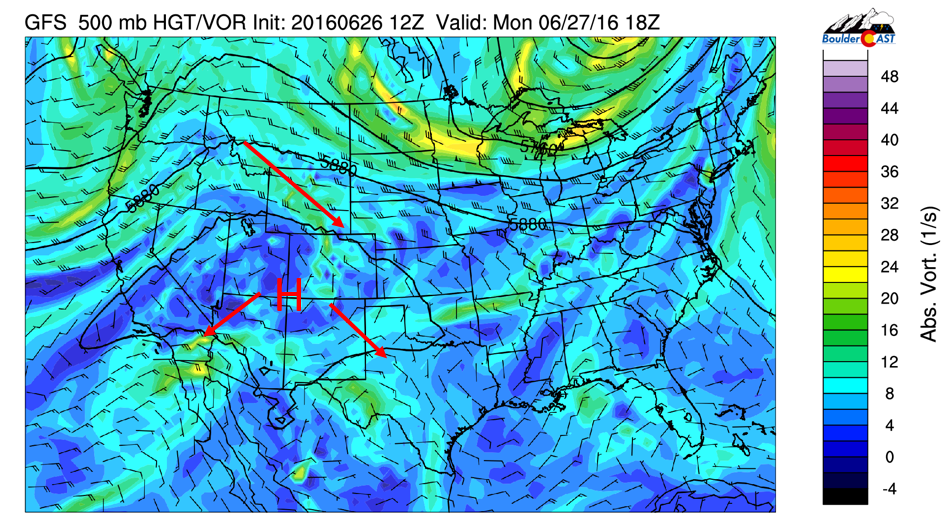
GFS 500 mb vorticity for Monday
The red arrow to the north over Wyoming denotes a weak trough moving southeast tonight, bringing in a cold front to the Front Range late tonight and early Tuesday morning. This trough is also embedded in a weak portion of the jet stream, as indicated in the figure below on the right (boxed in red). This will put the Plains in a region of divergence aloft for lift. In addition, instability for thunderstorms are quite modest, with values in excess of 2000 J/kg. During the day, expect highs upper 80’s to 90. In the evening after 6PM, scattered storms will be possible.
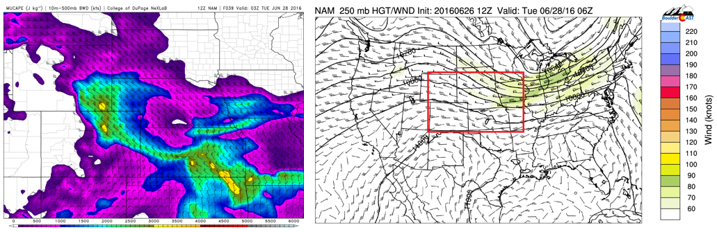
NAM forecast of convective instability (left) and upper level winds indicating divergence aloft (right) for tonight
The Storm Prediction Center has issued a slight risk of severe weather over the Front Range. The main threat of storms tonight will be heavy rain, hail, and gusty winds. Don’t be surprised if you are awakened by storms overnight tonight!
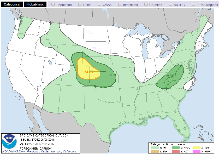
Storm Prediction Center severe weather outlook for this evening
Tuesday identical to Monday, with slightly more moisture
On Tuesday, much of the same atmospheric pattern will be in place compared with Monday. The ridge will be a little more to our southwest in response to the trough and cold front early Tuesday. Highs will not be prevented from reaching near 90 with the abundant sunshine in the morning and early afternoon. However, storm instability will again be strong to support thunderstorms to develop over the High Country and move southeast into the Foothills and Plains.
The forecast models are not consistent on the thunderstorm threat Tuesday. With a weak surface gradient, increased moisture, and instability, expect another round of scattered storms with the best time frame from 4-9 pm, some of which may be severe. The placement of these storms will be tough to pinpoint with some dying out as they move eastward into the Plains, so just keep an umbrella handy for the evening commute!

NAM forecast of convective instability (left) and 3-hourly precipitation (right) for Tuesday evening
Wednesday says goodbye to the mid-level ridge!
On Wednesday, another cold front pushes in as a larger trough situates itself across eastern Colorado and the Midwest. This front will be stronger than Monday night. The bottom left figure shows the cooler air pushing in from the northeast with upslope flow over the Plains and Foothills. This will further push the ridge to the southwest where it will remain the rest of the week. This cold front will lead to cooler air in the mid 80’s on Wednesday.
In addition, upslope flow and daytime heating will again support afternoon scattered storms to drift from the High Country onto the Plains. As with Tuesday, will be tough to pinpoint where the storms will form, but indications are that storms should be more widespread Wednesday compared with Tuesday.
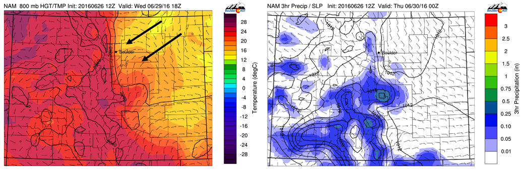
NAM 800 mb temperature (left) and 3-hourly precipitation (right) for Wednesday
Thursday and Friday cool and wet
On Thursday and Friday, the trough over the Midwest and eastern United States will remain in place with high pressure to our southwest over Arizona. Colorado will be on the cusp of the trough and ridge axes. This pattern will mean the Front Range and Foothills should see a stalled frontal boundary for Thursday and for the first day of July on Friday. The boundary will support surface-based lift, and, coupled with weak instability, will lead to afternoon showers/storms. Highs look to be in the lower 80’s Thursday with cloud cover and afternoon/evening showers/storms. There are indications Friday could see highs in the upper 70’s but confidence in this is low five days out. If you’re a Premium subscriber, be sure to check out our daily forecasts as we head towards the end of the week.
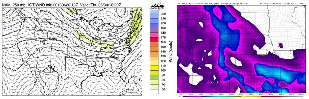
NAM 250 mb upper-level winds (left) and GFS convective instability (right) for Thu-Fri time frame
Below shows the GFS total accumulated precipitation for the week. The majority of this predicted rainfall occurs in the time frame Wednesday through Friday. The GFS is indicating about 1-2″ by week’s end. The GFS is known to over-estimate storm activity, but this pattern of increased rain and cooler weather is consistent in the long-range models.

GFS total accumulated precipitation ending Friday evening over Colorado
Extended outlook:
The extended forecast models are not consistent in the overall atmospheric pattern going into the 4th of July holiday weekend. The GFS is showing the mid-level ridge may inch northward again for highs to rise back to the low 90’s. However, the upper-level jet stream will still be across Colorado, leading to uncertainty of how warm it will get and whether storms will remain in the forecast. Look out for our holiday weekend update in a few days.
Enjoy your week!
The Forecast:
Monday: Mostly sunny and warm with upper 80’s over the Plains and upper 70’s in the Foothills. Scattered severe storms are possible after 6PM, ending after midnight. Main threat with the storms will be hail, gusty winds, and locally heavy rain.
Tuesday: Mostly sunny in the morning and afternoon, then increasing clouds with scattered storms developing mid-to-late afternoon. Highs near 90 on the Plains, with near 80 over the Foothills.
Wednesday: Mostly sunny early, then increasing clouds with scattered afternoon storms from 2PM onward, tapering off by sunset. A tad cooler than Tuesday. Highs in the mid to upper 80’s over the Plains and mid 70’s in the Foothills.
Thursday: Partly sunny in the morning, then mostly cloudy with scattered thunderstorms in the late afternoon and evening. Highs in the lower 80’s on the Plains and lower 70’s in the Foothills.
Friday: Mostly cloudy with scattered afternoon showers and storms possible. Highs in the upper 70’s with low 70’s over the Foothills.
Extended: Model forecasts are indicating a potential return of the mid-level ridge Saturday, for slightly warmer weather into the 4th of July weekend. However, storms cannot be ruled out with an active storm-track in place, especially over the High Country.
High Country: Monday will see only isolated daytime storms with the threat of overnight storms into Tuesday morning. On Tuesday, another round of isolated-to-scattered storms are possible. The best threat of storm activity will be from Wednesday through Friday, some being widespread. If you are hiking during this time frame, be sure to keep an eye on the skies and descend when threatening clouds appear. The 4th of July weekend will see isolated storms remaining Saturday, Sunday, and on Independence Day Monday.


