
Following a weekend of searing heat, this week’s temperatures will feel a little more comfortable at times. Despite the large-scale ridge remaining in place across the Southwestern USA, it will weaken a tad, and as a result, open the gates for a pair of backdoor cold fronts to enter northeast Colorado. Continue reading for our complete weekly outlook, including when we may see record heat, and which days bring the chance of rain to cool us off.
Heat on! Heat off!
The city of Boulder tied a record high temperature yesterday (Sunday), officially soaring to 97 degrees. This was our warmest day in nearly two years (since July 7, 2014). Other locations around town, including the Boulder Airport and NCAR Foothills Lab reached 99 degrees. BoulderCAST Station also recorded a high of 99 degrees. Unfortunately, we may be dealing with another record-breaking day this week…
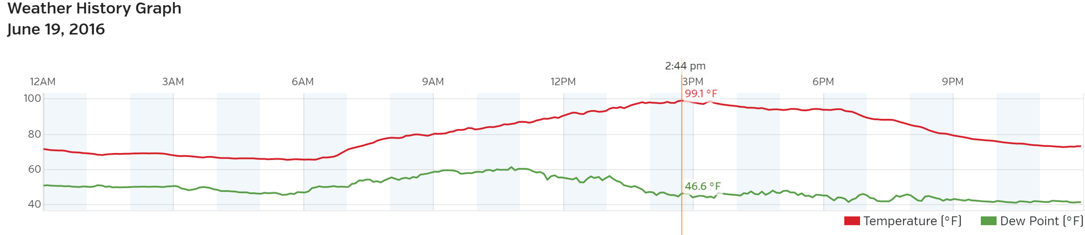
Boulder temperature (red) and dewpoint (green) plot for June 19, 2016 – BoulderCAST Station
Let’s start off with a current view of the atmosphere across the United States at the 500 mb level. The ridge that has dominated our weather for more than a week is still loitering on the streets of Colorado. Notice the core of the ridge below, the 6000-meter high across the Four Corners region.
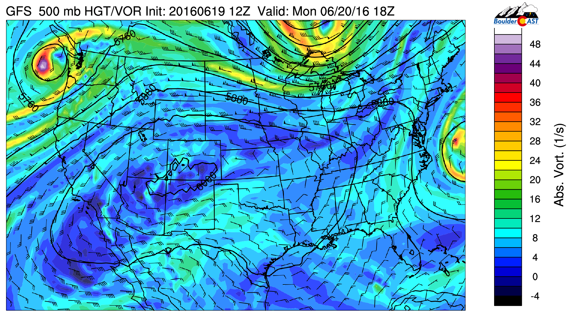
GFS 500 mb vorticity map for Monday, showing the ridge entrenched across Colorado
Though it is hard to tell from the map above, the trough across the Great Lakes region has a trailing cold front that has moved into Colorado earlier this morning. The northeasterly cool down is quite visible in the 800 mb temperature map below for noon Monday.
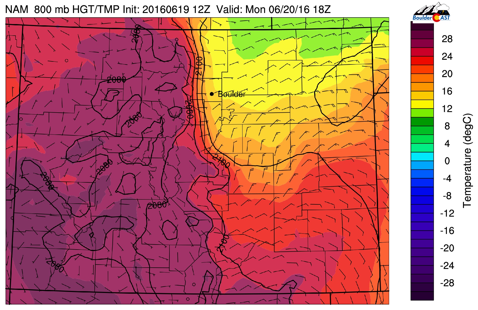
GFS 800 mb temperature forecast for the state on Monday. It’s easy to see the pool of cool air across the northeast Plains
This front will keep temperatures today some 15 to 20 degrees cooler today compared to yesterday. It will feel refreshing out there! The areas in and near the Foothills could be dealing with some stratus and light drizzle as well, particularly later this morning and early afternoon. This air mass is very shallow and is under-cutting the ridge (cool air below warm air). This doesn’t help provide much in the way of instability, but the weak upslope combined with daytime heating will produce a few isolated storms this afternoon. Highs will be in the low 80’s on the Plains.
As quickly as it cooled down, it will heat back up for Tuesday. As the cooler air retreats eastward, the ridge continues to pump more heat into the region. The 800 mb temperature map for Tuesday afternoon shows the warmest conditions will envelop Colorado.
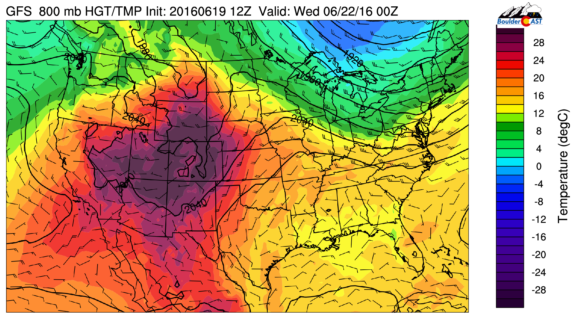
GFS 800 mb temperature forecast for Tuesday, showing an intense “bubble” of warmth across our region
We’ll once again be flirting with record heat Tuesday afternoon. Under mostly sunny skies, temperatures will climb into the upper 90’s and possibly low 100’s across the Denver Metro area. Not bad for the first full-day of summer! A few isolated storms will be possible, but those should remain across the higher terrain south of our area.
Continued warmth with Mountain storms Wed through Fri
By Wednesday, the ridge flattens further, so much so that it extends zonally across the entire southern United States (seen below). Our next backdoor cold front moves in as well in the morning.
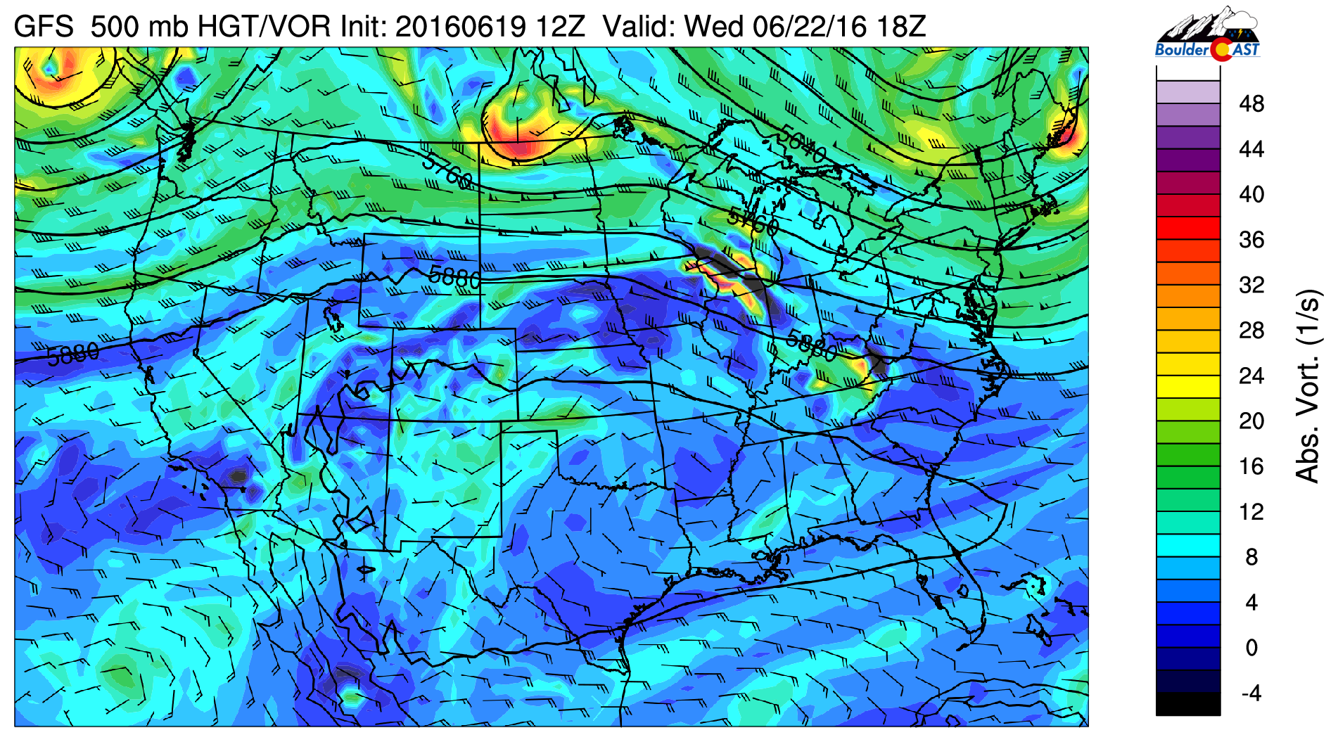
GFS 500 mb vorticity map for Wednesday. The ridge has flattened, but largely remains intact. The northern fringe of the country is in the midst of a very active storm track!
The front doesn’t appear to be quite as strong as Monday’s, but it will bring a welcomed cool-down to the region. Highs will be in the mid 80’s. Storms will be spotty again, and mostly across the Mountains.
Not much changes into Thursday or Friday (as you can tell from the similar looking 500 mb forecast map for Friday below).
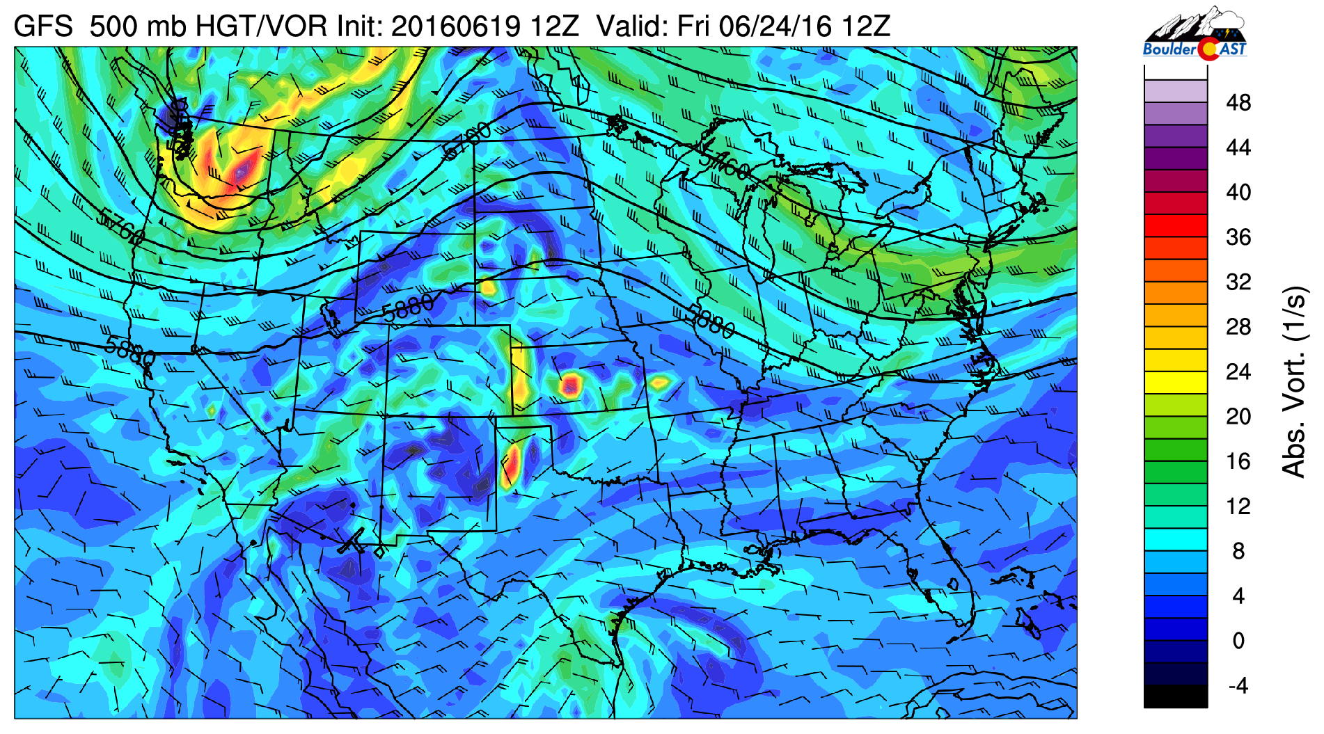
GFS 500 mb vorticity map for Friday. Not much change from Wednesday’s map
Temperatures will be above normal, but not likely record-breaking. Expect low to mid 90’s both days. Spotty afternoon storms will continue, mostly across the higher terrain. As of now, the best chance of rain for the lower elevations appears to be Thursday afternoon/evening as a little more moisture invades the state, but even then, many places will remain dry!
Enjoy the mostly dry, and at times, hot week ahead!

GFS total accumulated precipitation through Friday. Precipitation will mostly be confined to the Mountains, and south of Denver
The Forecast:
Monday: Sun early, then increasing clouds by late in the morning with some light drizzle possible. Isolated light rain showers on the Plains through the day, with spotty thunderstorms across the higher terrain. Highs in the lower 80’s on the Plains, with low 70’s in the Foothills.
Tuesday: Mostly sunny and very hot with near record-breaking heat. Isolated storms across the Mountains and Foothills south of Denver. Highs in the upper 90’s across the Plains, with mid 80’s in the Foothills.
Wednesday: Mostly sunny skies and cooler with spotty afternoon showers and thunderstorms, mostly across the higher elevations. Highs to top out only in the mid 80’s on the Plains, with mid 70’s in the Foothills.
Thursday: Increasing clouds with scattered afternoon thunderstorms for the Foothills, isolated storms for the Plains. High temperatures in the low 90’s for the Plains, upper 70’s in the Foothills.
Friday: Partly sunny and hot. A few isolated afternoon storms will be possible, mostly across the higher elevations. Highs for the Plains in the low 90’s, with near 80 in the Foothills.
Extended: Model forecasts are indicating warm weather sticking with us into next week as the flattened upper-level ridge prevails. Overall, the upcoming weekend looks quite warm/dry for most locations. Just a stray storm or two for the higher terrain both days.
High Country: We can’t rule out afternoon storms forming across the Mountains any day this week. More widespread storm coverage will be possible south of Interstate 70 through the week, especially Wednesday and Thursday. Just about everywhere will see a slight risk for storms each day this week. Temperatures will be above to well-above normal through the week.


