
We hope you enjoyed the hot, humid, and at times, stormy weekend. The first part of the week ahead will feature continued thunderstorm activity, some of which will be severe. By Wednesday, the heat wave returns. Just how hot will it get? Continue reading for our full outlook of the upcoming week.
Widespread storms, a few severe, to start the week
The week starts off with a continuance of Sunday’s weather. Yesterday, highs were in the middle 80’s across the Plains with scattered storm activity developing over the High Country and trekking east-northeast onto the Plains by early evening. A similar weather setup will be with us today.
The below 500 mb vorticity map indicates a weak shortwave trough centered over northern Arizona this afternoon. This disturbance will be tracking northeast through the day, providing lift for another round of storms developing this afternoon. With a similar airmass to Sunday, highs will be just a tad cooler with clouds developing by noon-time (low 80’s).
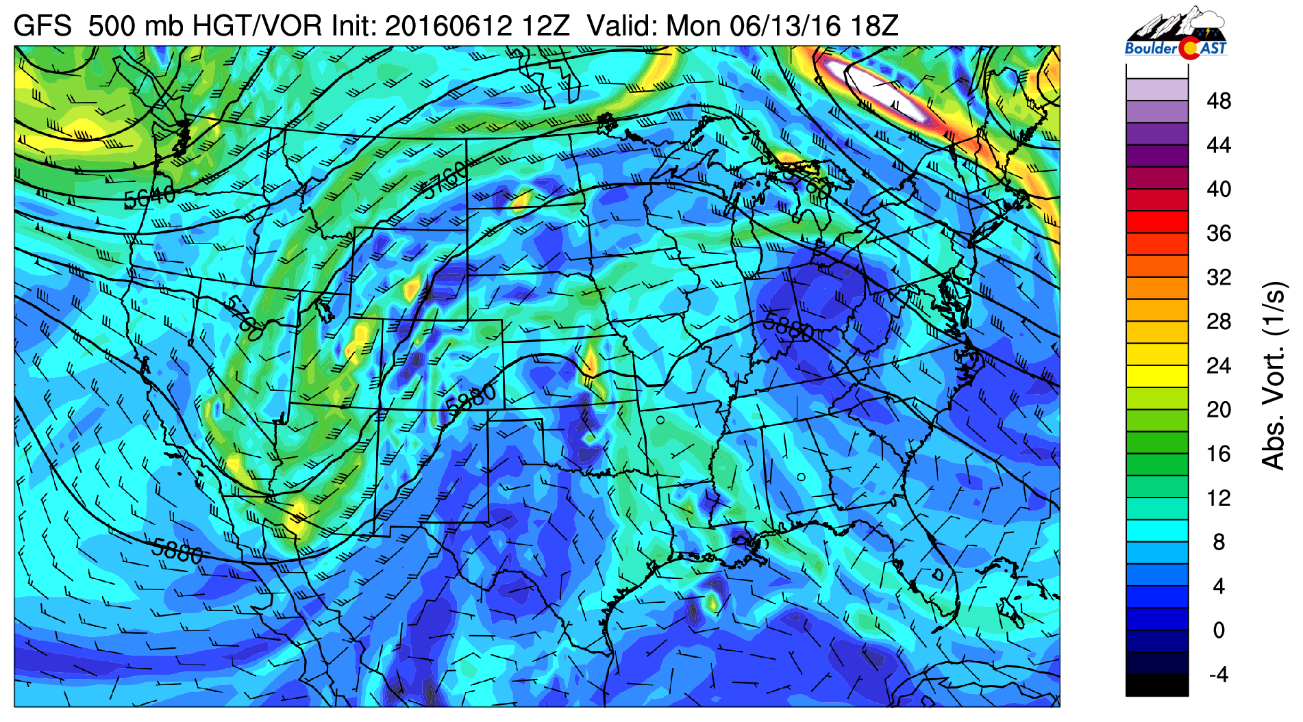
GFS 500 vorticity for this afternoon
Combined with the lift in the upper-levels of the atmosphere, the amount of moisture will be well above average. Below shows that precipitable water values (the total integrated moisture through the depth of the atmosphere) will be close to 200% of normal today, enough to create localized heavy rainfall.
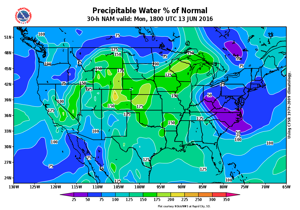
NAM model forecasted percent of normal precipitable water for this afternoon. Map courtesy of the National Weather Service
The Storm Prediction Center has issued a slight to enhanced risk of severe weather across the Plains and northeastern Colorado. Cold air aloft and lift from the approaching trough will create a risk of large hail. Damaging winds and heavy rain are also possible with the above normal moisture across the region. In addition, low-level easterly flow will combine with upper-level southwesterly flow to produce wind shear to support a few tornadoes east and south of Denver. The greatest severe threat will be in areas along and east of Denver, but everyone should be on alert today!
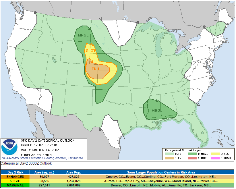
Storm Prediction Center Severe Outlook (issued Sunday) for today. Denver and the Foothills are in a slight risk of severe weather
The NAM model is indicating widespread storms into the evening, merging into a larger complex over eastern Colorado and western Kansas.
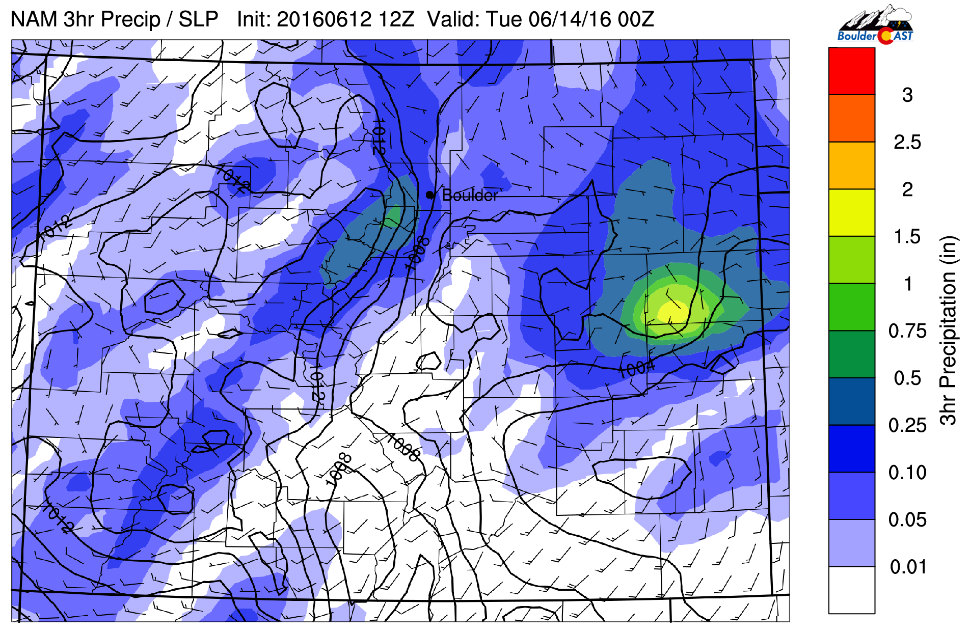
NAM model forecasted 3-hr precipitation for Monday afternoon/evening
In summary, these are the main factors for today’s storm threat:
- Storm activity will develop shortly after noon.
- Storms have the chance to become severe, with large hail, damaging winds, and a few tornadoes. Again, greatest risk of severe weather will be east and south of the Metro area
- Storms will linger into late evening, tapering off fully after midnight
A lull on Tuesday before the heat arrives
The upper-level trough pushes east of Colorado on Tuesday, ushering in slightly cooler air in the mid-levels of the atmosphere. However, downsloping winds and sunshine will allow highs on the Plains to rise into the middle 80’s. Enjoy Tuesday. It will be dry and is the last day before the heat wave returns.
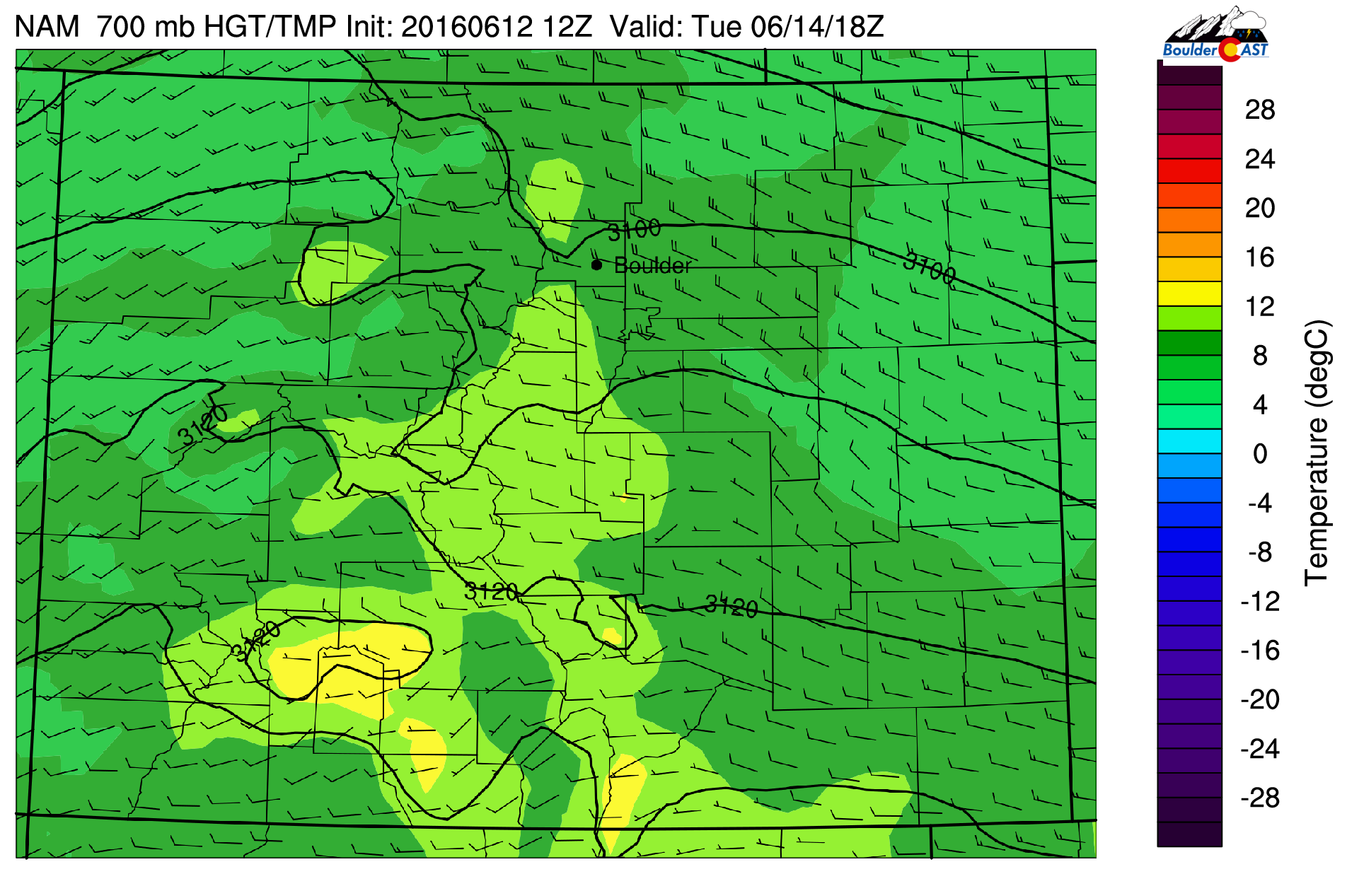
NAM 700 mb temperature forecast over Colorado
Hot second half of the week
Wednesday through Friday will feature a ridge of high pressure rebuilding across Colorado. In addition, an upper-level trough will be situated over the Pacific Northwest. These two atmospheric features will favor very warm and dry southwesterly flow from the Desert regions, leading to the return to 90’s and full sunshine.
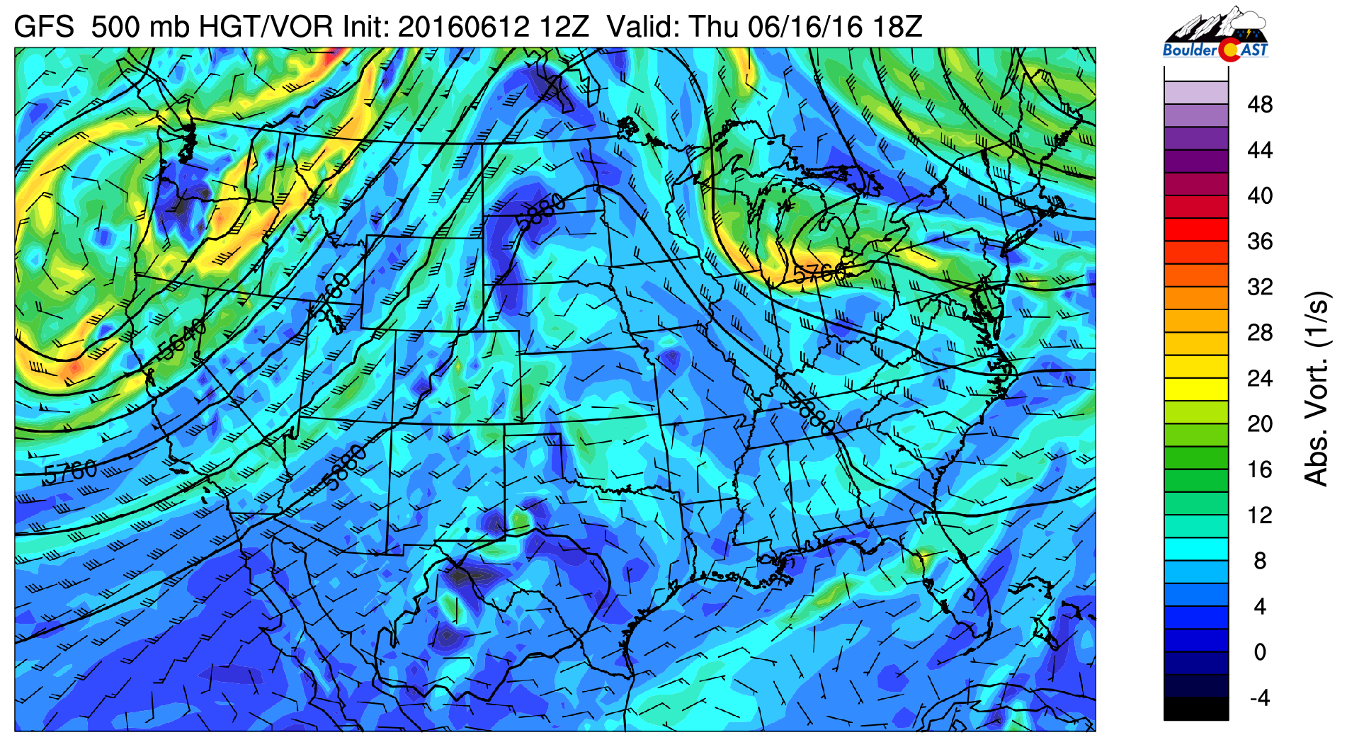
GFS 500 vorticity for Thursday
How dry will it be? The NAM model forecast is indicating below average moisture content across all of Colorado Wednesday. This dry air continues to envelop the region Thursday and Friday, giving us confidence that we should stay mostly rain-free, with only a few widely isolated storms over the High Country. Expect abundant sunshine as well!
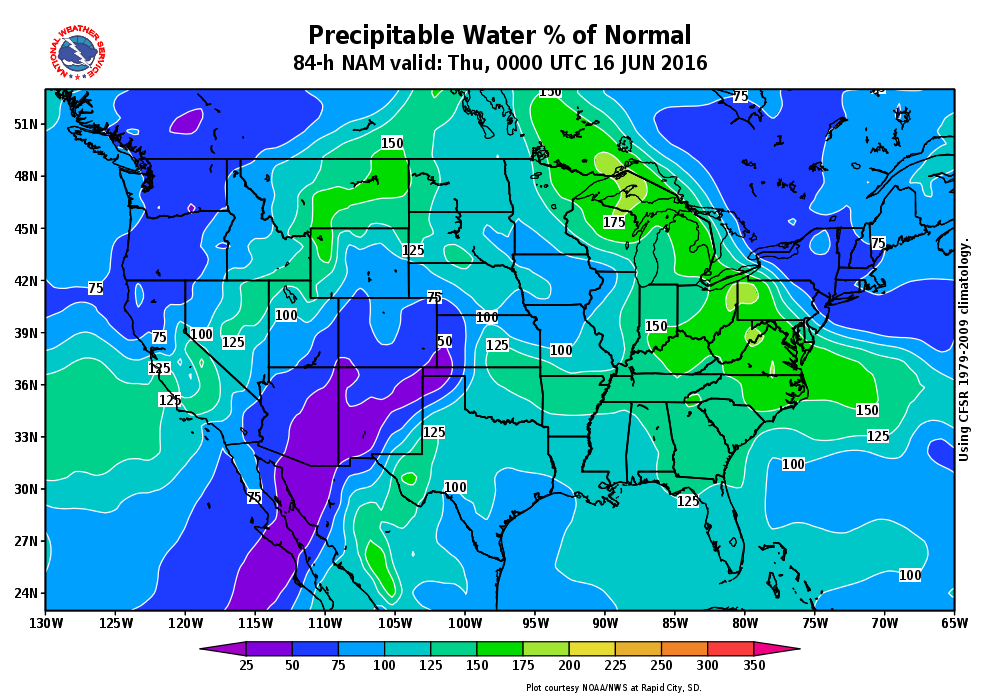
NAM model percent of normal precipitable water for Thursday. Map courtesy of the National Weather Service
How hot will it get? The long-range forecast models, including the GFS and Euro, are showing mid-level temperatures around 17 degress Celsius, supporting highs into the middle 90’s. However, we would not be surprised if some locations reach the upper 90’s. At this point, it looks like the hottest days will be Thursday and Friday.
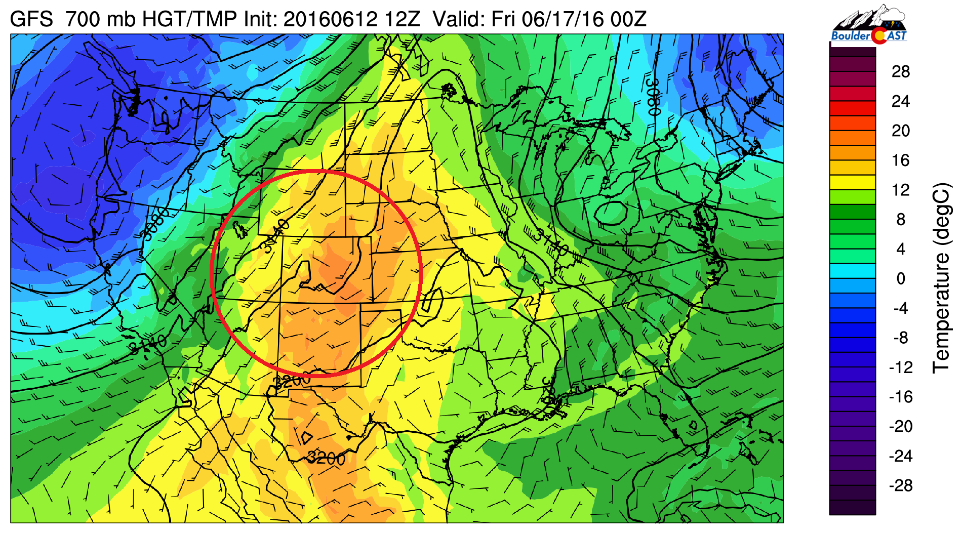
GFS 700 mb temperature for Thursday, showing temperatures near 17 degC, supporting middle 90’s over the Plains
Extended outlook
The extended forecast models are indicating that as we go into the weekend, the upper-level trough in the Pacific Northwest will move east across the Upper Midwest Saturday into Sunday, allowing a cold front to sag southward into Colorado. However, there is disagreement in regards to the timing of this front. In addition, the ridge of high pressure will dip ever-so-south into New Mexico. As this happens, coupled with the cold front, westerly flow will help bring in more moisture from the Pacific and lead to increased chances of storms over the High Country, especially late in the weekend. The Plains should not see an increased storm threat until early next week.
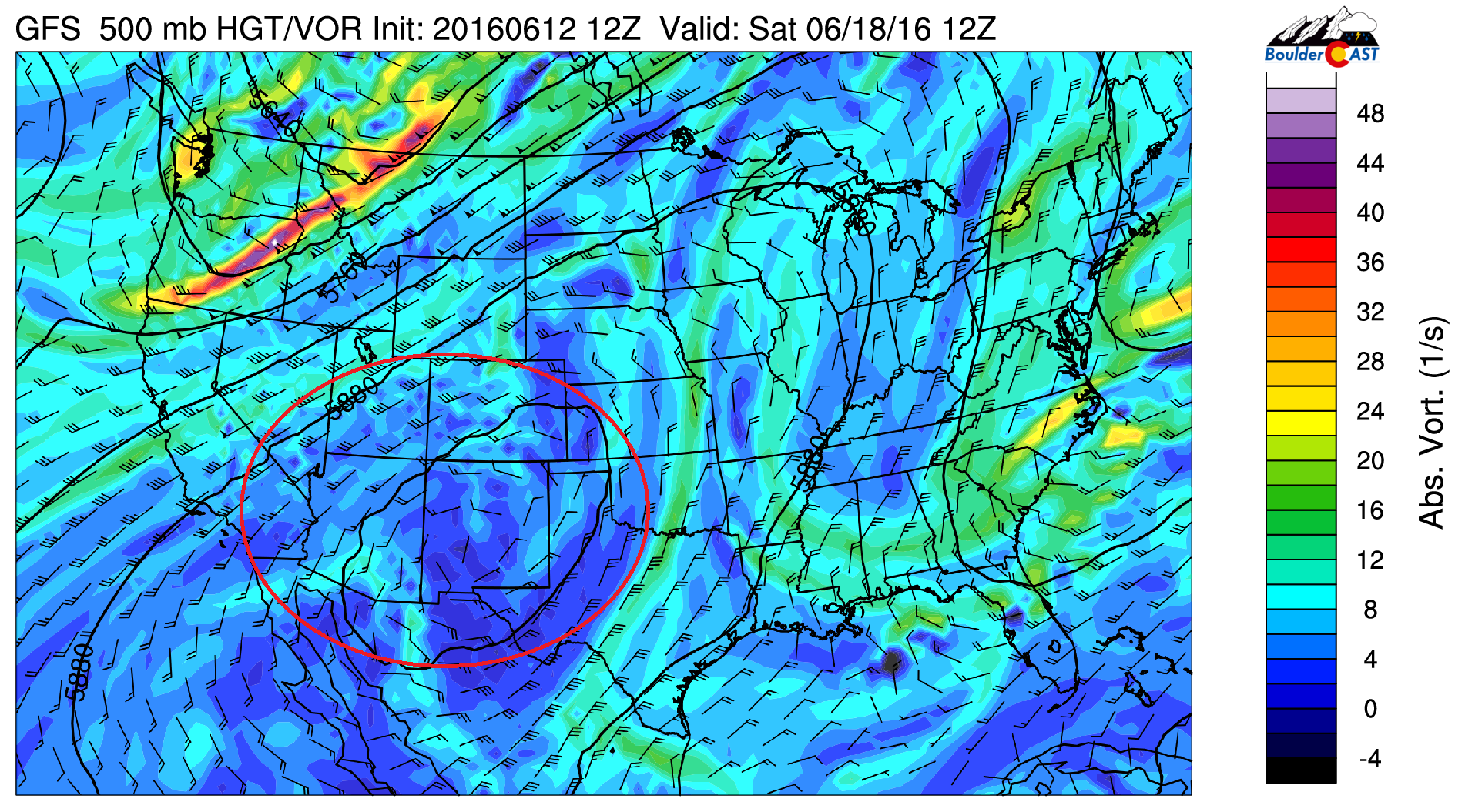
GFS 500 mb vorticity for the weekend, with the broad ridge circled in red
The Forecast:
Monday: Sun early, then mostly cloudy. Widespread thunderstorms forming during the afternoon hours, continuing into late evening. Storms could produce large hail, damaging winds, and a few tornadoes. Highs in the lower 80’s on the Plains, with upper 60’s in the Foothills.
Tuesday: A few morning clouds followed by afternoon sunshine. Highs in the middle 80’s over the Plains and low 70’s in the Foothills.
Wednesday: Mostly sunny skies and warmer. Highs in the lower 90’s on the Plains and near 80 in the Foothills.
Thursday: Sunny and hot with middle 90’s across the entire area of the Plains. Over the Foothills, expect highs in the middle 80’s.
Friday: Sunny, hot, and dry, with highs in the middle 90’s, with some upper 90’s not out of the question. Over the Foothills, highs in the middle 80’s.
Extended: Model forecasts are indicating hot weather to remain for Saturday, but a cool-down is possible Sunday and early next week, along with storm chances returning, especially in the Mountains.
High Country: Widespread storm activity will be in place over the mountains on Monday. On Tuesday and Wednesday, only a few isolated storms will be around. Thursday and Friday will see overall dry conditions with only a slight chance of a storm. For the upcoming weekend, the threat of storms increases, primarily Sunday.


