As we close out the month of July and move into the fourth week of monsoon season, somewhat drier air will take hold across Colorado and make for less storm activity overall this week. However, a significant cool-down is likely towards the latter part of the week ahead. Read on for details.
Quiet Monday and Tuesday
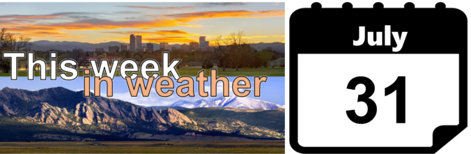
Today the ridge of high pressure will be centered across northern Nevada and drier northwesterly flow will take hold across Colorado.
GFS 500 mb vorticity map for Monday evening showing a ridge to our west and weak northwest flow across the state.
This flow has actually been in place the last several days, but remnant low-level moisture was “trapped” beneath the ridge and this helped to fuel storms the last two days (mainly closer to Denver). Scattered monsoon storms over the weekend have exhausted this low-level moisture pool for the most part, and as a result, we will be significantly drier today and on Tuesday.
Storms on Monday will be isolated for our region and remain mostly east and south of the Denver Metro area. On Tuesday, limited moisture and capping aloft will likely prevent the chance of storms entirely. Highs both days will be in the low to middle 80’s.
Cold front Wednesday night!?
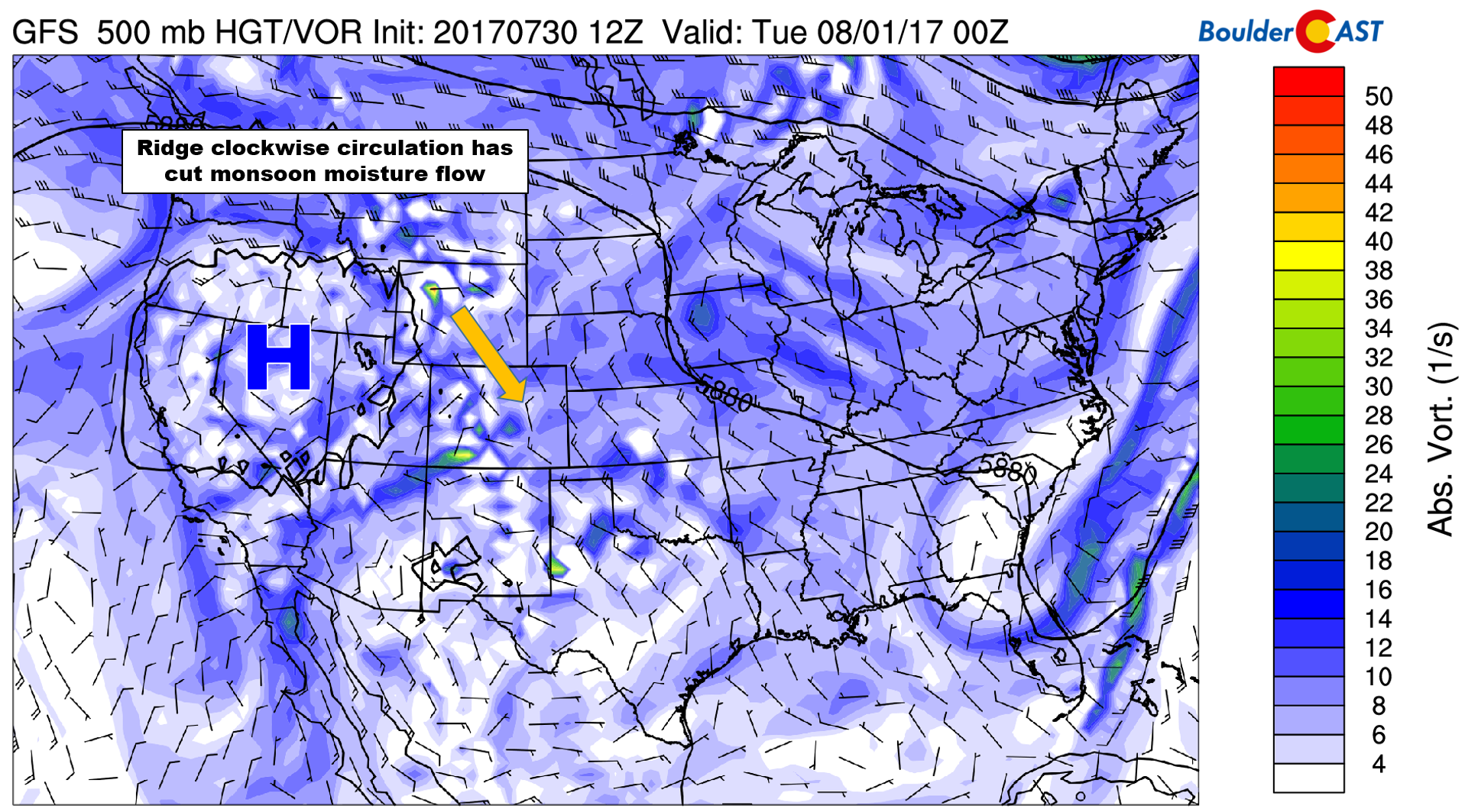
On Wednesday, we are tracking the potential arrival of a cold front associated with a trough moving across the northern Great Plains. The 500 mb map below shows the trough axis extending from Minnesota into Colorado, along with a “tail” of vorticity.
GFS 500 mb vorticity map for Wednesday night showing a trough axis pushing across Colorado.
The front’s timing is a little questionable, and even its potential existence is not certain. Not all models are showing this feature reaching Colorado, but it looks likely that it will. Depending on the timing of this front, highs Wednesday will be anywhere from 80 to 90 degrees. Our best chance of rain for the week will come Wednesday evening and night as this front passes. Thunderstorms should be scattered in nature and may linger well into the overnight hours.
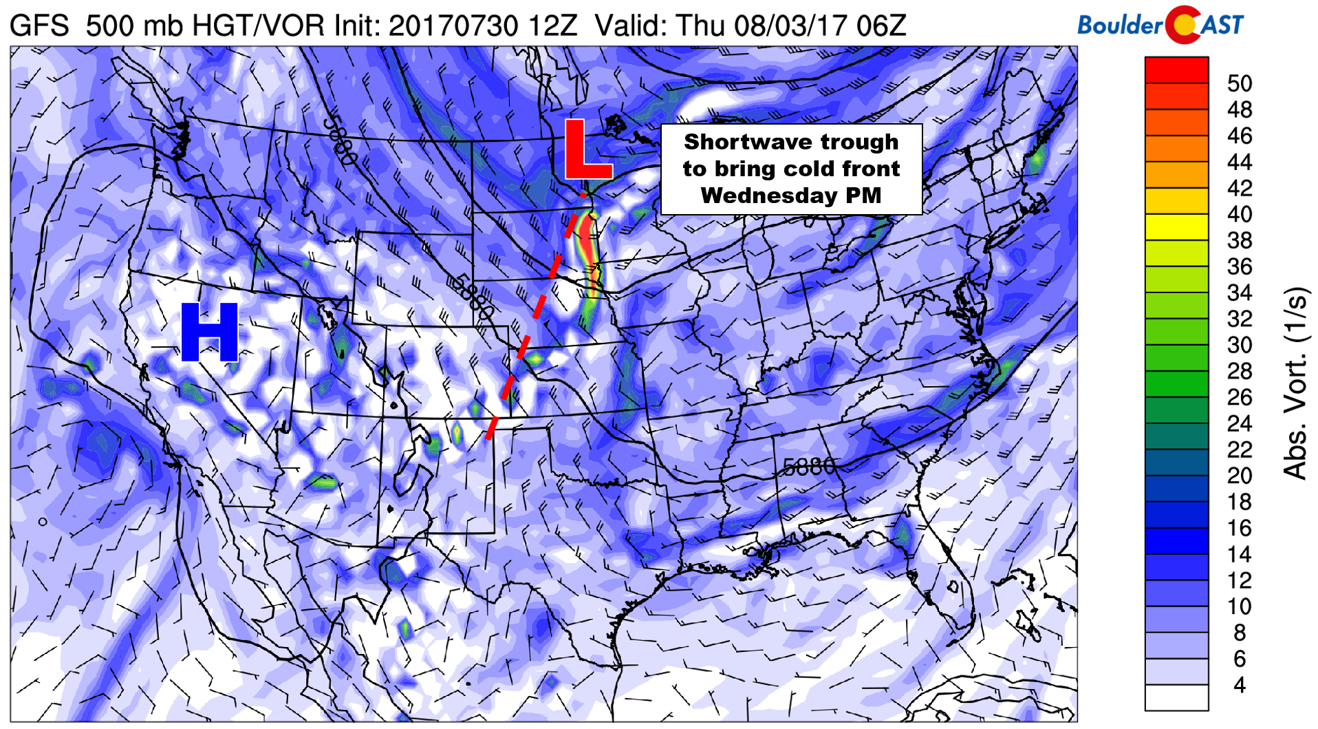
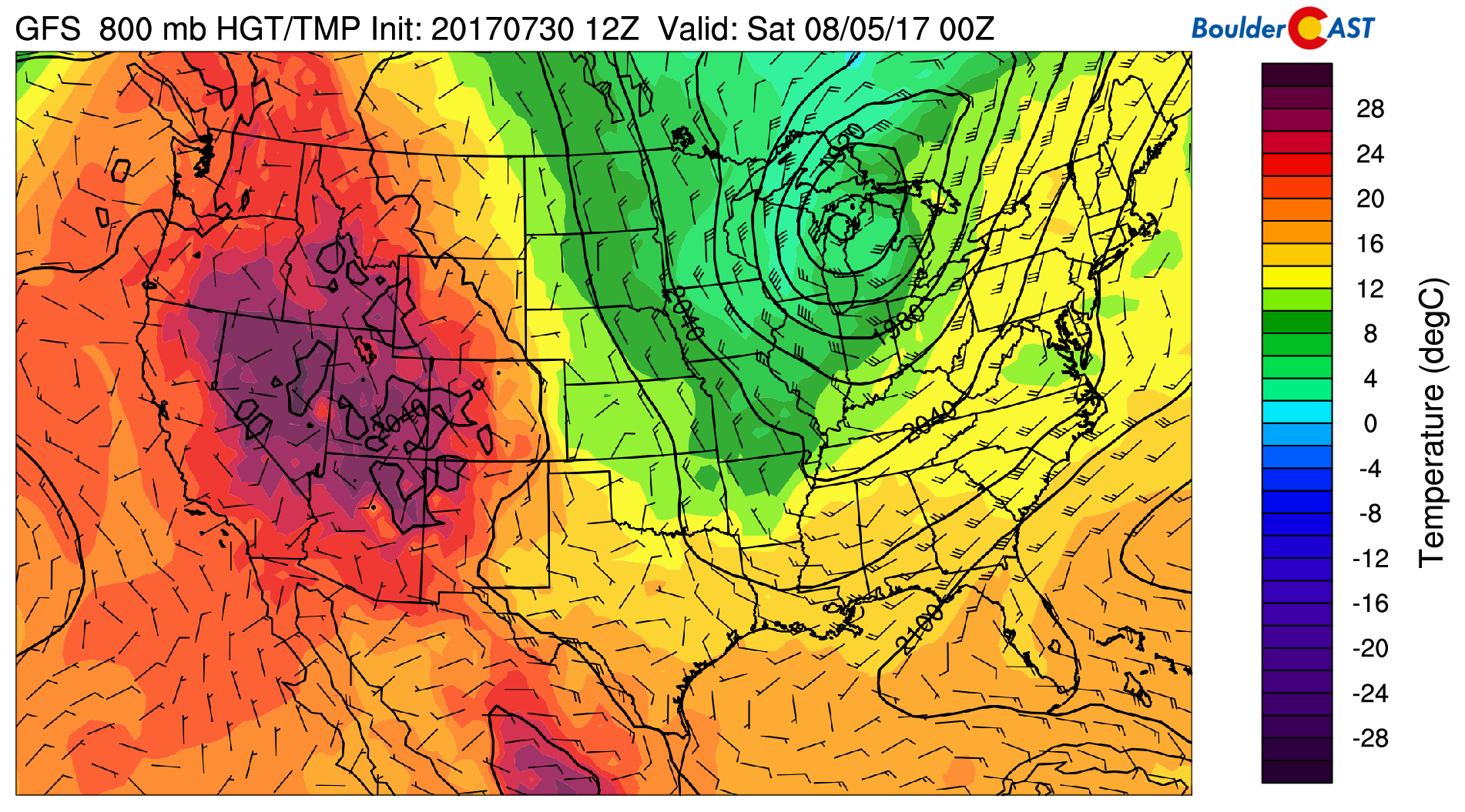
The 800 mb temperature map from the NAM below shows readings around 7 degrees Celsius. This could equate to temperatures dropping into the upper 40’s in spots Thursday and Friday mornings.
NAM 800 mb temperature map across Colorado showing the cold airmass entering the state Wednesday night.
Chilly to end the week
Models project that the trough across the northern Great Plains will deepen significantly towards the close of the week. The end-result is the 500 mb map below, one that looks more like it belongs in October than it does in August!
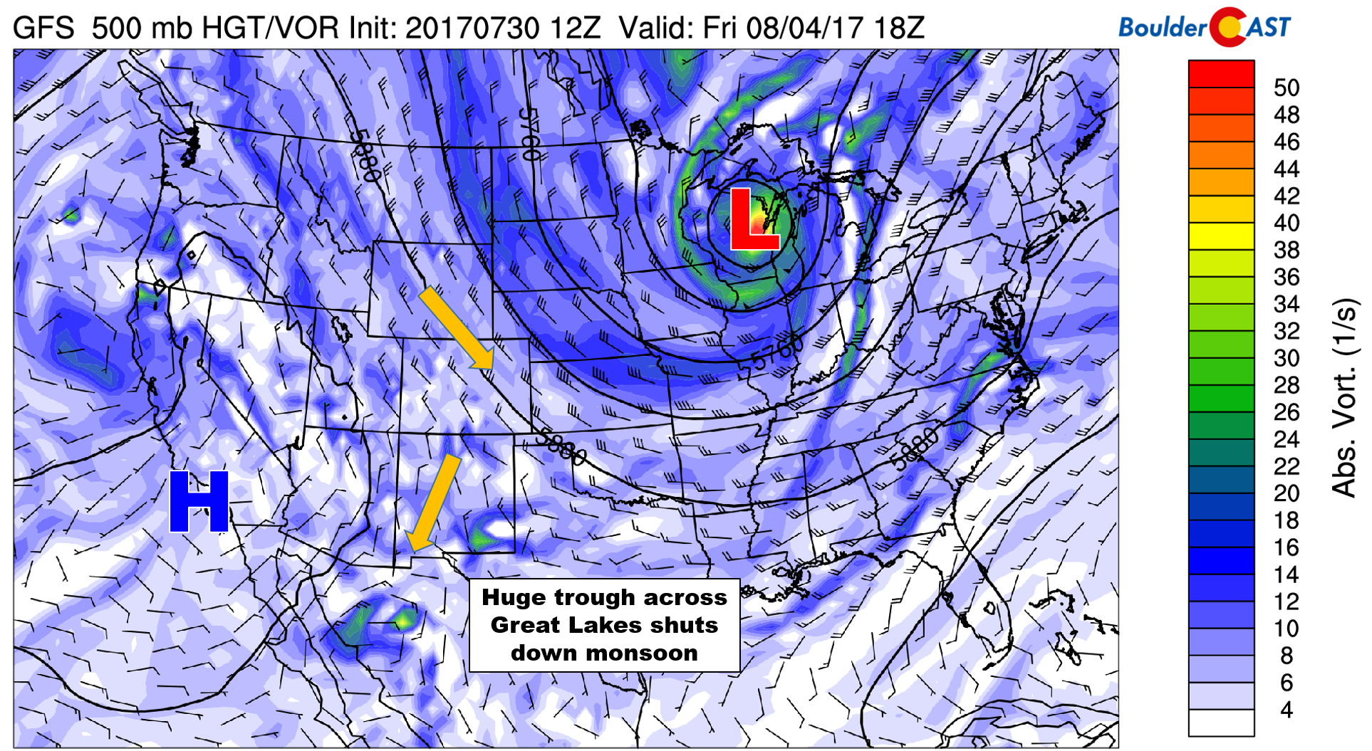
GFS 500 mb vorticity map for Friday afternoon showing a massive trough across the Great Lakes, with unseasonably strong northwest flow across Colorado.
This trough could be too much for the monsoon to handle. The northerly flow will push well past Colorado into northwestern Mexico, effectively shutting of the faucet of moisture into the southwestern United States (for a few days at least).
GFS 500 mb temperature map for Friday evening showing the cold airmass on the backside of the trough.
The eastern two-thirds of the country will see below normal temperatures thanks to this huge trough, while the northwest will be baking underneath the ridge.
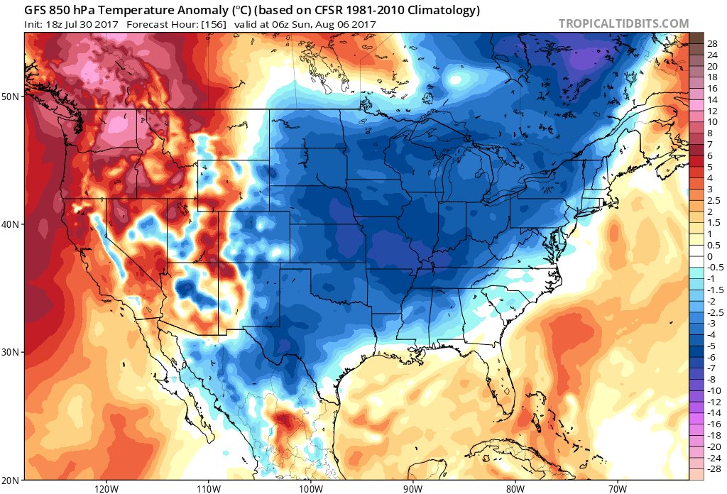
GFS 850 mb temperature anomalies for Saturday showing cooler than normal weather for the eastern two-thirds of the country.
What does this mean for Colorado? It’s still a few days out and we’re not 100% sold on this massive trough yet. If it does verify, Thursday will likely be cool, cloudy, and rainy for the Front Range. Highs Thursday are forecast to remain below 75 degrees, and possibly below 70 depending whether any sun can make it through the clouds. Friday will be somewhat drier but still cool with highs in the 70’s as well.
Statistically speaking, Tuesday is the warmest day of the year for Boulder. The decline of our daily average temperatures begins on Wednesday and continues into early January. Enjoy the mid-summer cool-down that’s on the way!
Forecast Specifics:
Monday: Partly cloudy early with mostly cloudy skies in the afternoon. Isolated storms are possible, especially south and east of Denver. Highs across the Plains will be in the low 80’s with low 70’s in the Foothills.
Tuesday: Morning sunshine and just a few afternoon clouds and dry weather. Highs in the middle 80’s across the Plains, with middle 70’s in the Foothills.
Wednesday: Morning sun with increasing clouds during the day. A cold front is expected to reach the area during the late evening. This will increase moisture, lower temperatures, and provide the forcing for scattered thunderstorms which will linger into the the overnight hours. Temperatures will top out in the low to middle 80’s on the Plains and in the mid 70’s in the Foothills.
Thursday: Cloudy and cool with on-and-off showers through the morning and afternoon. Temperatures will only peak in the low to middle 70’s across the Plains with low 60’s in the Foothills. Some locations could set record low-highs for the date (coldest daytime high temperatures).
Friday: Partly cloudy with widely scattered afternoon and evening thundershowers, primarily across the higher elevations. Highs climb a few degrees to near 80 degrees for the Plains, with upper 60’s in the Foothills.
High Country: Afternoon heating will drive isolated storms across the higher elevations on Monday, with generally dry conditions prevailing on Tuesday (by far the best day to hike this week!). Wednesday and Thursday will see scattered to widespread storms, especially across the Front Range Mountains as the cold front and more moisture arrive. Isolated storms will linger into Friday. Near normal or slightly below normal temperatures are on tap for the week in general. Thursday and Friday will see atypically strong northwest winds sustained at 25 to 35 mph.
Find the best days to hit the mountains with our SummitCAST page. The first 2 days are always free. Upgrade to BoulderCAST Premium to unlock all 6 days.
| Day: | Parameter: |
|---|
To celebrate the launch of SummitCAST, through July 31st (hey that’s today!) use the promo code SUMMIT to receive a 33% discount on an annual subscription to BoulderCAST Premium. The final price is just $26.80 per year!

Share our forecast:
Mon
Tue
Wed
Thu
Fri


Temperature
85
85
86
72
79


Precip Chc (Plains)
10%(pm)
0%
40%(pm)
30%
20%(pm)


Where you have: “Climatologically, Tuesday is the warmest day of the year for Boulder”; I believe you meant “warmest day of the week”?
I actually do mean warmest day of the year. The average high on August 1st is 87 degrees. The decline begins on August 2nd and continues into early January.
Ahh, I see. Statistically…
Thanks!
Thanks to you…updated the wording….