
It’s hard to believe that the first week of July is already upon us. Soon we will be talking about the arrival of the summer monsoon. For now though, heat will be the story much of this week, with a few if any storms to speak of. We also discuss the forecast for the Fourth of July holiday and the possibility of 90’s lingering longer than anyone wants. Read on for the details.
Trough to start the week
Our weather today will be influenced by a weak trough of low pressure over eastern Colorado (see below). This same system was across western Colorado Sunday and was the main reason for storm activity across the High Country and the cloud cover across the Plains. With the system off to our east, northwest flow will ensue at the surface, denoted by the red arrow. The trough should aid in storms once again across the mountains, with some drifting onto the Plains….though, most will die out with the general downslope flow at the surface. Expect sunshine giving way to increasing clouds in the afternoon and evening. We should not have a problem rising to the low 90’s with the warm airmass overhead.
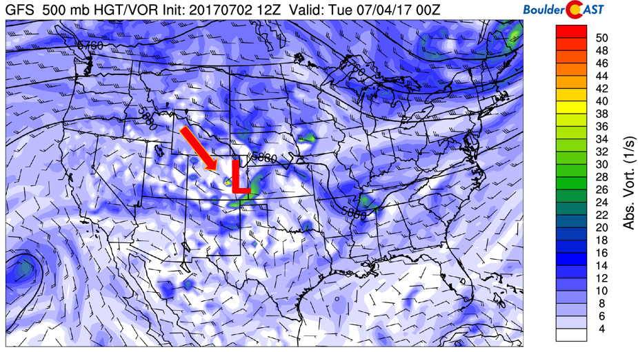
GFS 500 mb absolute vorticity for today
Happy 4th!
On Tuesday, much of the same pattern will be in place. The aforementioned low pressure system will have moved off into eastern Kansas. However, in its wake, northerly mid-level flow (below) will ensue across northeast Colorado. As a result, light upslope during the day will keep temperatures once again in the lower 90’s. Mid-level moisture and heating across the High Country will aid storm development in the mountains; some may drift south-southeast into the Foothills and western adjacent Plains in the early evening, with again most of these dying out upon their travels. Regardless, expect to see clouds working in for the afternoon/evening hours.
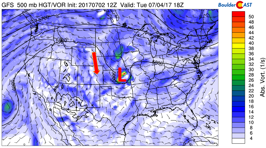
GFS 500 mb absolute vorticity for Tuesday
Below shows the forecasted precipitation from the GFS for Monday and for the 4th on Tuesday. As we mentioned, both days will see storm activity in the High Country. Little if any of these storms will survive once they reach the lower elevations. However, we still need to be cautious, especially when out and about for the fireworks Tuesday night. At best, bring a jacket in case a storm pops up in your area Tuesday!
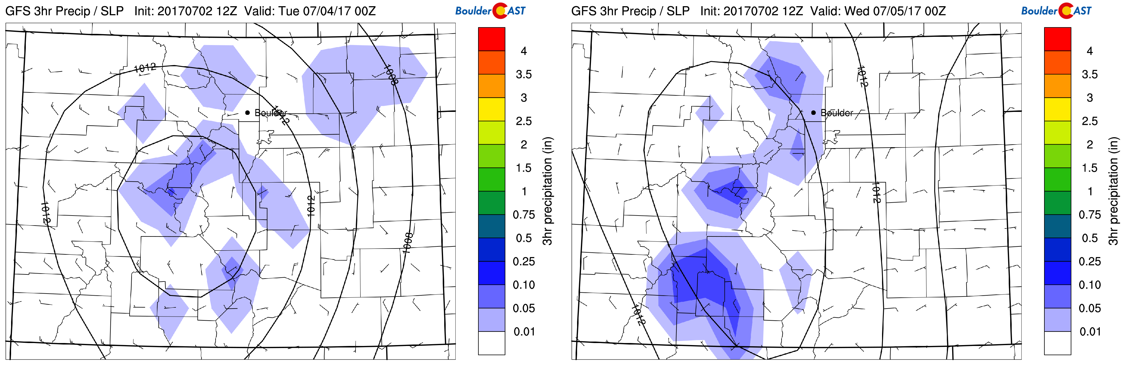
GFS precipitation forecast Monday (left) and Tuesday (right)
Heat, heat, and more heat!
On Wednesday and Thursday, a large dome of high pressure will park itself across much of the inter-mountain West, as depicted below. As a result, lots of heat and sunshine will be the norm. The ridge of high pressure will keep the storm track to the north and west (red arrows), so Colorado will largely remain dry. However, it appears the High Country will again be on the threat for isolated storms due to daytime heating and mid-level moisture. Highs Wednesday and Thursday look to go into the middle 90’s for the Denver Metro area.
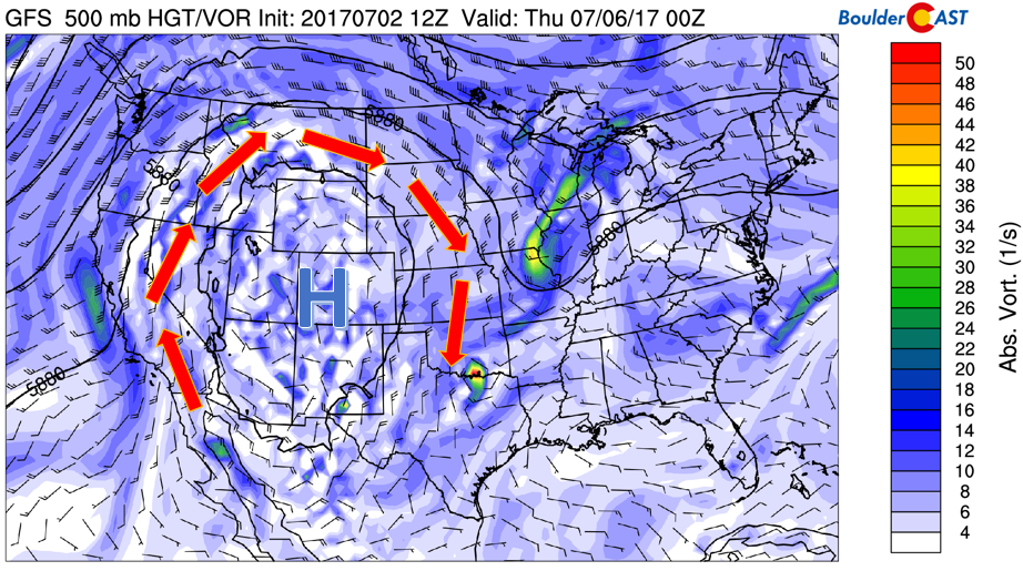
GFS mid-level flow pattern for Wednesday and Thursday
Possible Front Friday?
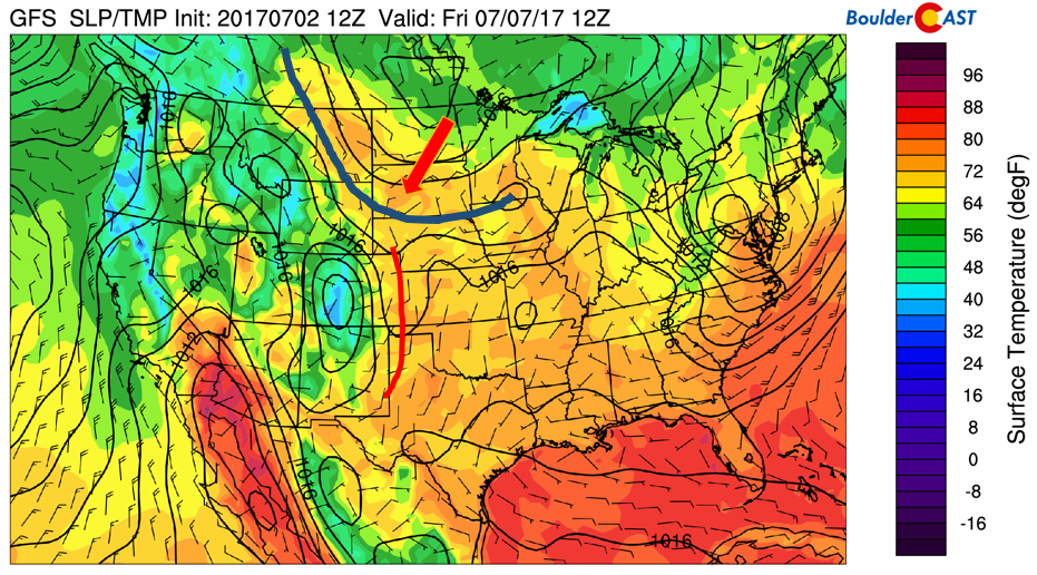
With summer here, it’s rather difficult for cold fronts out of Canada to reach us given the weak jet stream this time of year. However, they can still influence the region. Late Thursday and Friday, a few of the global forecast models are depicting a weak cold front moving south out of Canada (blue line below). At the same time, a lee trough (red line) is across eastern Colorado. Whether this front actually makes its way to our region is uncertain (most models keep it to our north). It will be something worth watching though as it could aid as a focal point for storm development if later forecast runs bring it closer. Either way, as it stands now, we should see temperatures remain in the 90’s to end the first week of July.
In fact, if this front doesn’t arrive by the end of the week, we could be looking at a lengthy stretch of 90+ degree days. Beginning this past Sunday, 10+ days may not be out of the question. The heat has arrived!
GFS surface temperature and wind for Friday morning
Enjoy your week and have a safe and enjoyable Fourth of July holiday!
Forecast Specifics:
Monday: Sunshine in the morning, with increasing clouds in the afternoon. A few isolated storms can’t be ruled out in the early evening, though most of us to stay dry. Expect highs near 90 on the Plains, with low 80’s in the Foothills.
Independence Day: Mostly sunny in the morning, then increasing clouds in the afternoon with a few isolated storms making their way onto the Plains and Foothills. Highs near the low 90’s across the Plains and low 80’s in the Foothills.
Wednesday: Mostly sunny and hot with storm activity staying confined to the High Country. Expect highs in the middle 90’s for the Plains and middle 80’s for the Foothills.
Thursday: Mostly sunny and hot. Expect highs in the middle 90’s for the Plains and middle 80’s in the Foothills.
Friday: Partly cloudy skies with a slight chance of afternoon storms across the Plains. Highs in the low 90’s on the Plains and low 80’s in the Foothills.
High Country: We’re expecting afternoon/early evening storms each day this week. This will be scattered in nature so if you are hiking, just be on the lookout for threatening skies and head to the lower elevations if this occurs.
Share our forecast:
Mon
Tue
Wed
Thu
Fri


Temperature
90
91
94
95
92


Precip Chc (Plains)
20%(pm)
10%(pm)
0%
0%
10%(pm)


.


