
After a very dry stretch through much of July, this week will feature a strong shift in the weather pattern that will allow for monsoonal moisture to spread in from the southwest, leading to chances for thunderstorms each day. Outside of the storms, temperatures will also warm each day with highs climbing back into the 90’s. Read on for our full forecast and which days we expect the best likelihood of monsoon rainfall.
Monsoon flow Monday through Wednesday
As well advertised here at BouderCAST, the monsoon is making a mark just in time for the middle of July! Below shows the 500 mb mid-level flow in the atmosphere for this evening. Noted in black is the area of high pressure. The position of this ridge over Oklahoma will remain relatively stationary from today through Wednesday. Due to that, southwesterly mid-level flow will aid in transporting subtropical moisture northward into our state, as shown in the red arrow. This large-scale pattern will set the stage for monsoonal moisture and increased chances for storms.
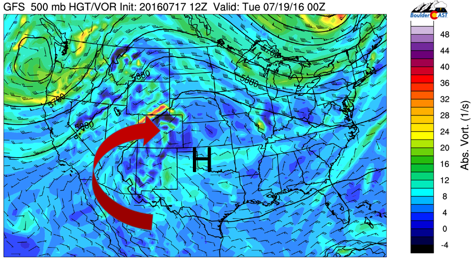
GFS 500 mid-level flow for Monday through Wednesday and associated absolute vorticity
Below shows the associated moisture content in the atmosphere from Monday through Wednesday across Colorado, denoted as the precipitable water. Values are at or above 1 inch through midweek. Monday shows the highest moisture content from the NAM forecast model.
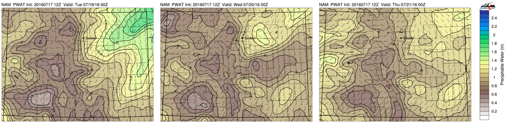
NAM model forecasted precipitable water for Monday (left), Tuesday (middle), and Wednesday (right), showing values at or above 1 inch
As a result, combined with surface instability in excess of 1000 J/kg of CAPE, both the GFS and NAM favor thunderstorms to take shape this afternoon and evening. Both models are quite different in their depiction of where storms will develop, but expect a good threat for storms today with weak upslope flow. Storms will be numerous in the High Country, so if you’re hiking, begin your descent when thunder begins to roar (or preferably, sooner). Expect highs today in the upper 80’s.
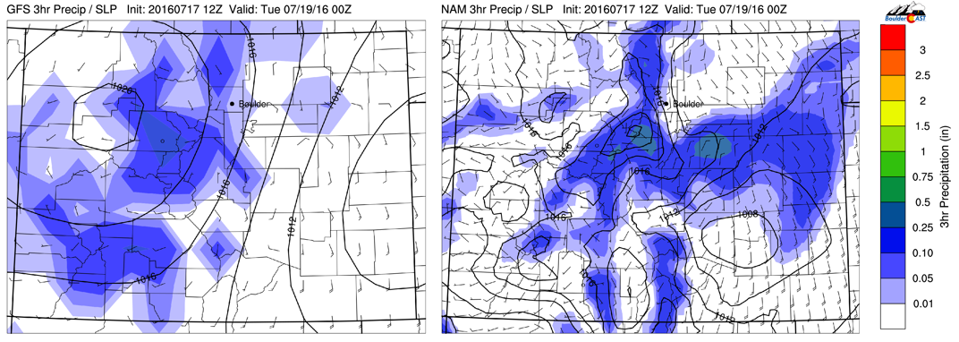
GFS (left) and NAM (right) 3-hr precipitation for this afternoon/evening
Not much will change in the atmospheric pattern Tuesday and Wednesday as the ridge of high pressure remains situated over Oklahoma with good monsoon moisture, as discussed earlier. The one thing that will change is 700 mb temperatures will rise to 18 degrees Celsius, which will support highs in the low and middle 90’s. However, with cloud cover and storm development in the afternoon and evening, this will somewhat limit our daytime heating. Either way, expect warmer weather Tuesday and Wednesday along with a good threat of storms in both the High Country and Foothills. The amount of storms reaching the Plains will depend on how much downslope flow there will be at the surface, which could prevent eastward movement of storms. Still, we think Tuesday and Wednesday are just as good as Monday for scattered storms over the state.
Monsoon weakens “slightly” to end the week
As we go into Thursday and Friday, the ridge of high pressure will slowly move westward into New Mexico, as depicted below. That will shift the monsoon plume to our west over Utah and bring a more westerly flow to the region as opposed to southwesterly. This will usher in somewhat drier air. Thus, the monsoon appears to weaken in the latter part of the week, but only “slightly” as there will still be plenty of instability and surface heating with highs close to the middle 90’s to end the week. This coupled with a weak surface pressure gradient will keep the threat of storms in the forecast.
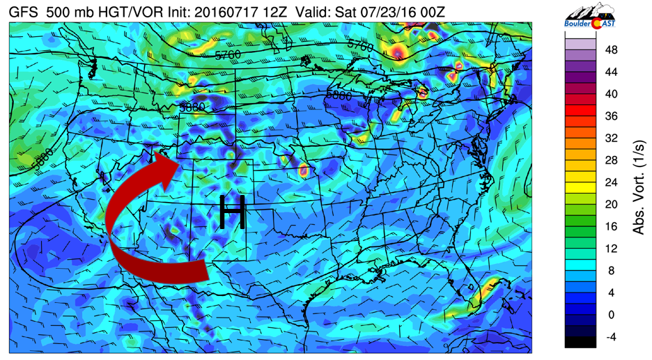
GFS 500 mb mid-level flow for Friday
Below shows the accumulated precipitation from the NAM (through Wednesday; left) and the GFS (through Friday; right). Both models show anywhere from 1-3″ of precipitation across the High Country. The models differ in regards to the amount of precipitation on the Plains. Forecasting convective storm cells is very difficult, especially in this pattern for the week, Some locations will not see much; others may see much more (with flash flooding not out of the question)!
Bottom line: expect warming temperatures from the 80’s to eventually middle 90’s to end the week, along with scattered thunderstorms each day.
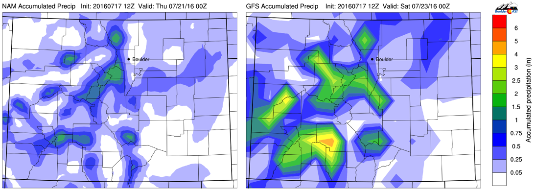
NAM accumulated precipitation (through Wed) and GFS accumulated precipitation (through Fri)
Forecast Specifics:
Monday: Mostly sunny skies with increasing afternoon clouds and scattered thunderstorms developing in the High Country and moving eastward toward the Plains. Storm activity will be active until late evening. Highs in the upper 80’s over the Plains and lower 80’s in the Foothills. Monday will likely be the “wettest” day of the week.
Tuesday: Mostly sunny, followed by afternoon showers and thunderstorms in the High Country, Foothills, and portions of the Plains. Highs near 90 on the Plains and lower 80’s in the Foothills.
Wednesday: Sunny skies followed by scattered afternoon/evening thunderstorms. Highs in the lower 90’s on the Plains and lower 80’s in the Foothills.
Thursday: Sun early, then increasing clouds with isolated to scattered storms in the afternoon and evening. Highs in the lower 90’s on the Plains and lower 80’s in the Foothills.
Friday: Mostly sunny skies with isolated to scattered afternoon storms in the afternoon and evening. Highs near the middle 90’s over the Plains and middle 80’s in the Foothills.
High Country: Numerous scattered showers and thunderstorms will be across the mountains through the entire week. As a result, highs will be cooler with the rain and clouds. The downside is you will have to hike very early to avoid early development of storms.
Extended: Model forecasts are showing that the mid-level ridge may flatten out somewhat over the Desert Southwest, leading to a more westerly flow aloft to bring in drier air. This may lead to a weakening of the monsoon over the coming weekend and early next week.
Mon
Tue
Wed
Thu
Fri


Temperature
88
90
92
93
95


Precip Chc (Plains)
40%
30%
30%
20%
20%


