

A rather benign period overall is headed our way with high pressure in place through most of the upcoming week. However, we will need to be on the lookout for thunderstorms toward the latter part of the week with the return of monsoonal moisture. Prior to that, heat will be the story. Read on for our detailed weekly forecast.
It’s all about the heat Monday through Wednesday
The mid-level pattern for today and tomorrow is shown in the below two-panel plot of 500 mb absolute vorticity. A broad ridge of high pressure is situated over the state today and tomorrow. With this pattern in place, monsoonal moisture will remain west of the state for the most part, as indicated by the yellow arrow. This will keep the bulk of daytime thunderstorm activity across the High Country.
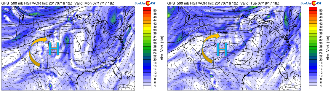
GFS 500 mb absolute vorticity for today (left) and Tuesday (right)
The precipitation forecast both days (below) from the GFS, as expected, keeps precipitation primarily west of the Denver Metro area. We are not ruling out, however, some isolated storms each day given the monsoon in place.
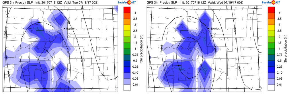
GFS precipitation forecast today (left) and Tuesday (right)
As for high temperatures, with the exception of clouds in the late afternoon and early evening from isolated thunderstorms, we should see generally sunny skies with highs reaching the low to middle 90’s. The 700 mb low-level temperatures (below) are in the 18-20 degree Celsisus range, a very hot airmass indeed!
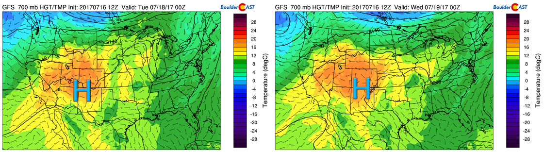
GFS 700 mb temperature, wind, and height pattern for today (left) and Tuesday (right)
Much of this same pattern will exist on Wednesday, although the chance of storms will increase slightly with temperatures once again in the middle 90’s.
Monsoon flow returns Thursday & Friday
The monsoonal flow will shift eastward by the end the week. As depicted below, the ridge of high pressure pushes ever so slowly to the east of Colorado over the Oklahoma panhandle. That will allow moist southwesterly flow to return from Arizona.
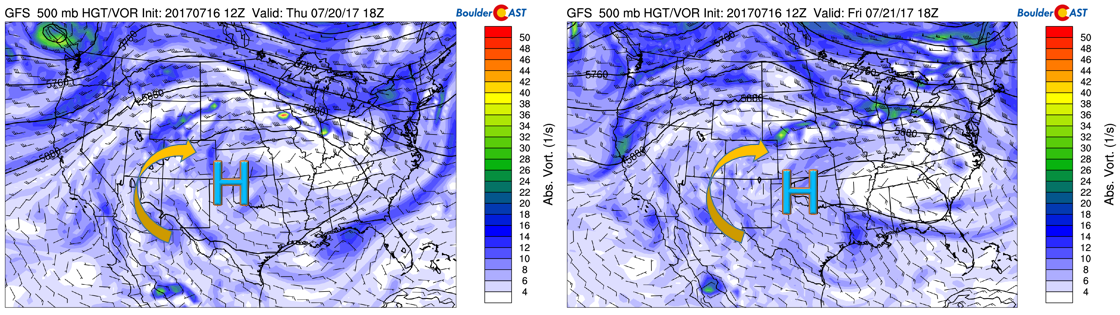
GFS 500 mb absolute vorticity for Thursday (left) and Friday (right)
The precipitation forecast thus calls for a more eastward shift in the region of thunderstorms, extending further eastward into Colorado, with Boulder and Denver included. This is depicted in the GFS below. This is all due to a southwesterly mid-level flow helping to move these storms eastward off of the mountains. While we can’t rule out a few storms Monday through Wednesday, it appears at this point that Thursday, Friday, and even part of the upcoming weekend will see the best chance of thunderstorm activity for the Plains.
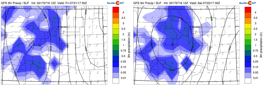
GFS precipitation forecast for Thursday (left) and Friday (right)
Much of the same airmass will be in place to end the week. However, with more clouds for the forecast Thursday and Friday alongside the prediction of more storms, highs will cool a few degrees Thursday and end to around the upper 80’s by Friday.
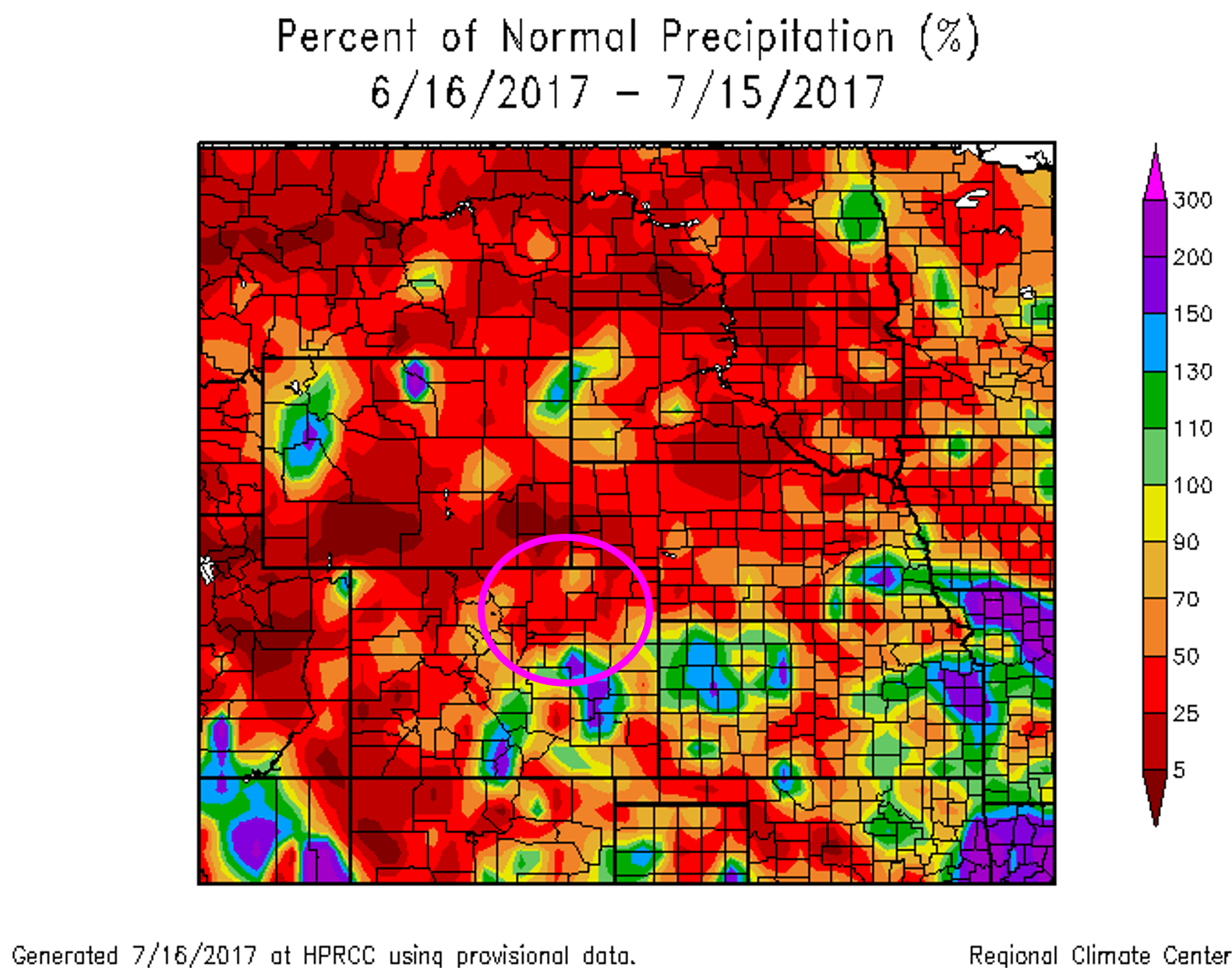
Let’s hope for some rainfall as we could really use the precipitation. Boulder has recorded just 0.03″ of rain thus far in July…a big problem considering this usually one of our wettest months of the year.
Enjoy your week!
Forecast Specifics:
Monday: Mostly sunny skies giving way to increasing clouds. A few isolated storms cannot be ruled out on the Plains, but most of us to remain dry. Expect highs in the lower 90’s on the Plains, with lower 80’s in the Foothills.
Tuesday: Partly cloudy skies giving way to increasing clouds by late afternoon. A few widely isolated storms are possible, but these should remain mostly west of the Denver Metro. Highs in the middle 90’s across the Plains and lower 80’s in the Foothills.
Wednesday: Partly sunny skies giving way to mostly cloudy skies by late afternoon. Scattered thunderstorms in the late afternoon and early evening. Expect highs in the middle 90’s across the Plains and lower 80’s for the Foothills.
Thursday: Mostly sunny skies becoming mostly cloudy with scattered showers and thunderstorms possible in the late afternoon and evening. Some may produce heavy rainfall. Expect highs in the low 90’s for the Plains and upper 70’s in the Foothills.
Friday: Mostly cloudy with scattered showers and thunderstorms possible in the late afternoon and evening. Some may produce heavy rainfall. Highs in the upper 80’s on the Plains and middle 70’s in the Foothills.
High Country: We’re expecting dangerous afternoon/evening storms each day this week. If you are hiking over the mountains this week, start early. The best days to hike look to be Monday and Tuesday with fairly isolated storms. More widespread storms appear likely Wednesday through Friday and part of the upcoming weekend.
Find the best days to hit the mountains with SummitCAST.
Share our forecast:
Mon
Tue
Wed
Thu
Fri


Temperature
93
94
96
91
88


Precip Chc (Plains)
10%(pm)
10%(pm)
20%(pm)
30%(pm)
40%(pm)


.


You must be logged in to post a comment.