
This week we discuss the arrival of the summer monsoon which will facilitate some of the best chances of rain we have seen in weeks.
It’s been dry, but that’s normal
Thanks to a persistent ridge of high pressure, it hasn’t rained more than a few drops across the Denver Metro area in the last two weeks. This extended dry period has been observed across almost all of the western United States.
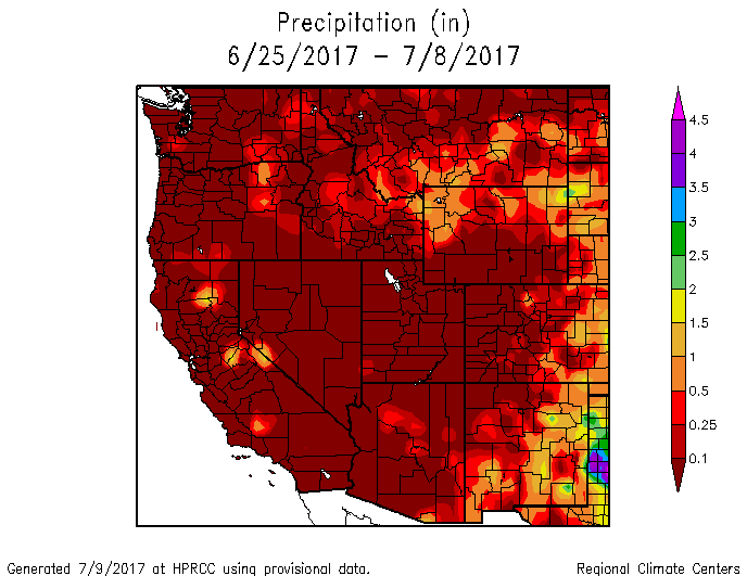
Total accumulated precipitation for the western United States since June 25, 2017.
For our region at least, this isn’t all that abnormal. Late June and the first week of July are one of the drier times of year on average for Denver (see blue line in the graph below).
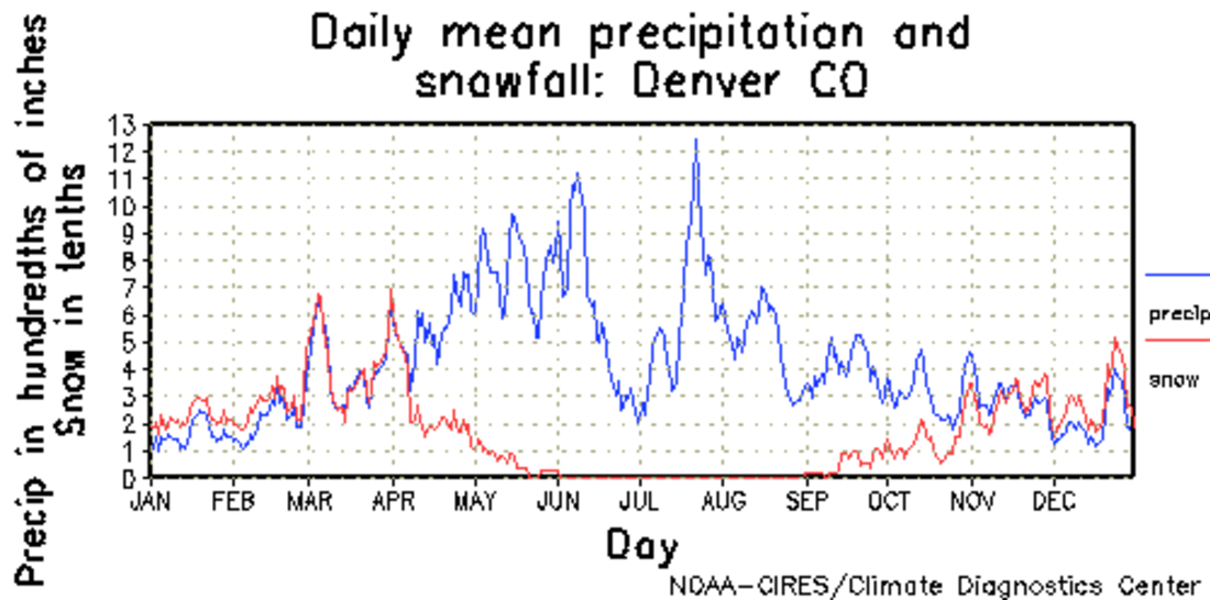
Daily mean precipitation and snowfall amount in Denver. Notice the huge dip in precipitation potential late June/early July.
This time frame is typically characterized by a brief lull in the action between our spring upslope season and the summer monsoon. As we projected in a post last week, the monsoon is starting to materialize for the Desert Southwest. We will begin to feel the initial effects by mid-week here in Colorado.

Average daily dew point data for Tucson, AZ. The 54-degree “monsoon” threshold was exceeded for the first time yesterday!
Ridge builds as monsoon plume arrives to USA
The main story for the week ahead will be the arrival of the summer monsoon moisture plume to the southwestern Unites States. The water vapor loop below from GOES-R shows the moisture streaming into Arizona and Utah at this time.
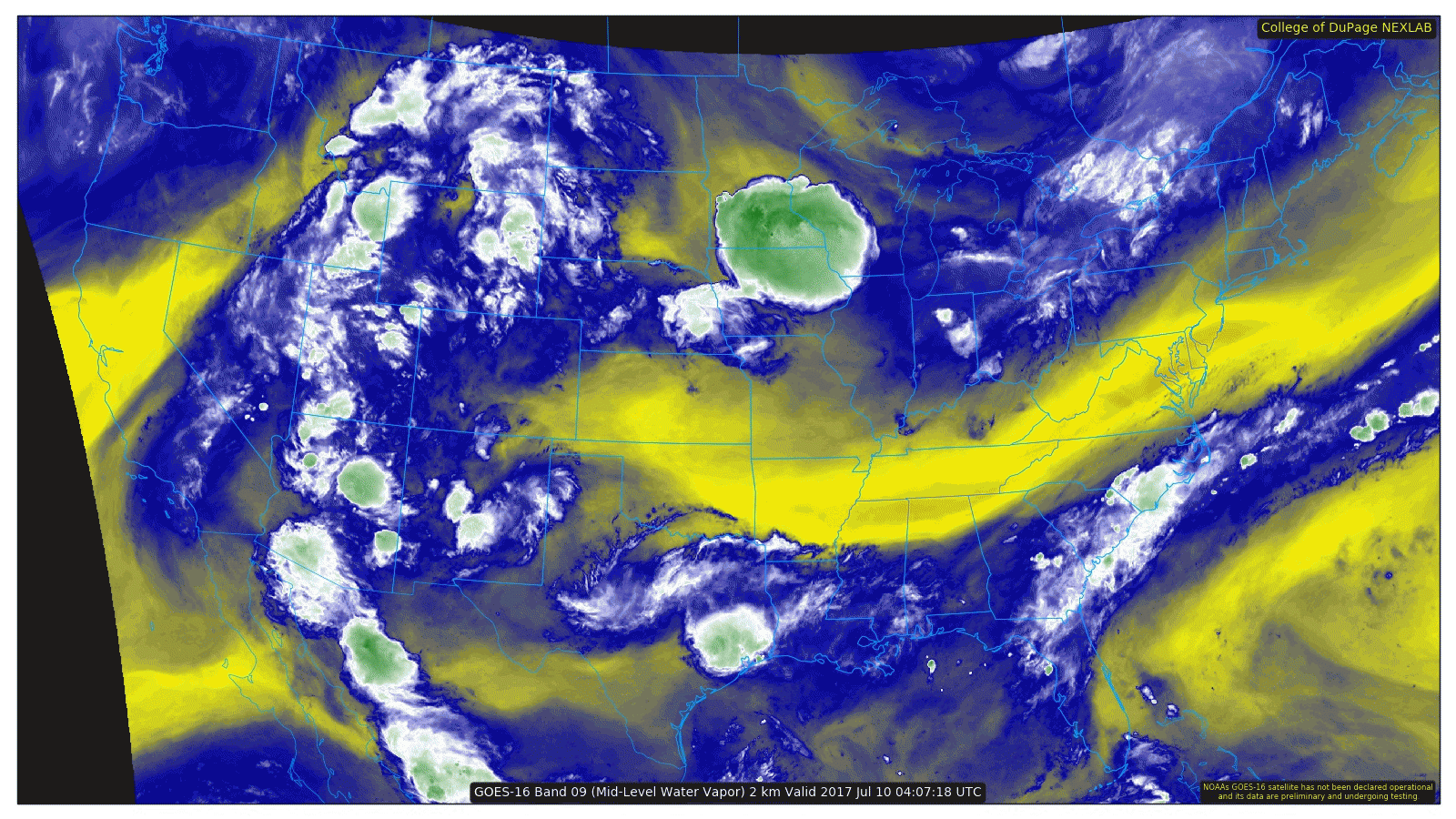
Water vapor loop showing monsoon clouds and moisture stretching from western Mexico northward into Utah
However, the flow pattern will not be ideal to bring the plume directly to Colorado, at least for any length of time. The precipitable water anomaly map below for today shows the best moisture sits to our west in Utah and Nevada.
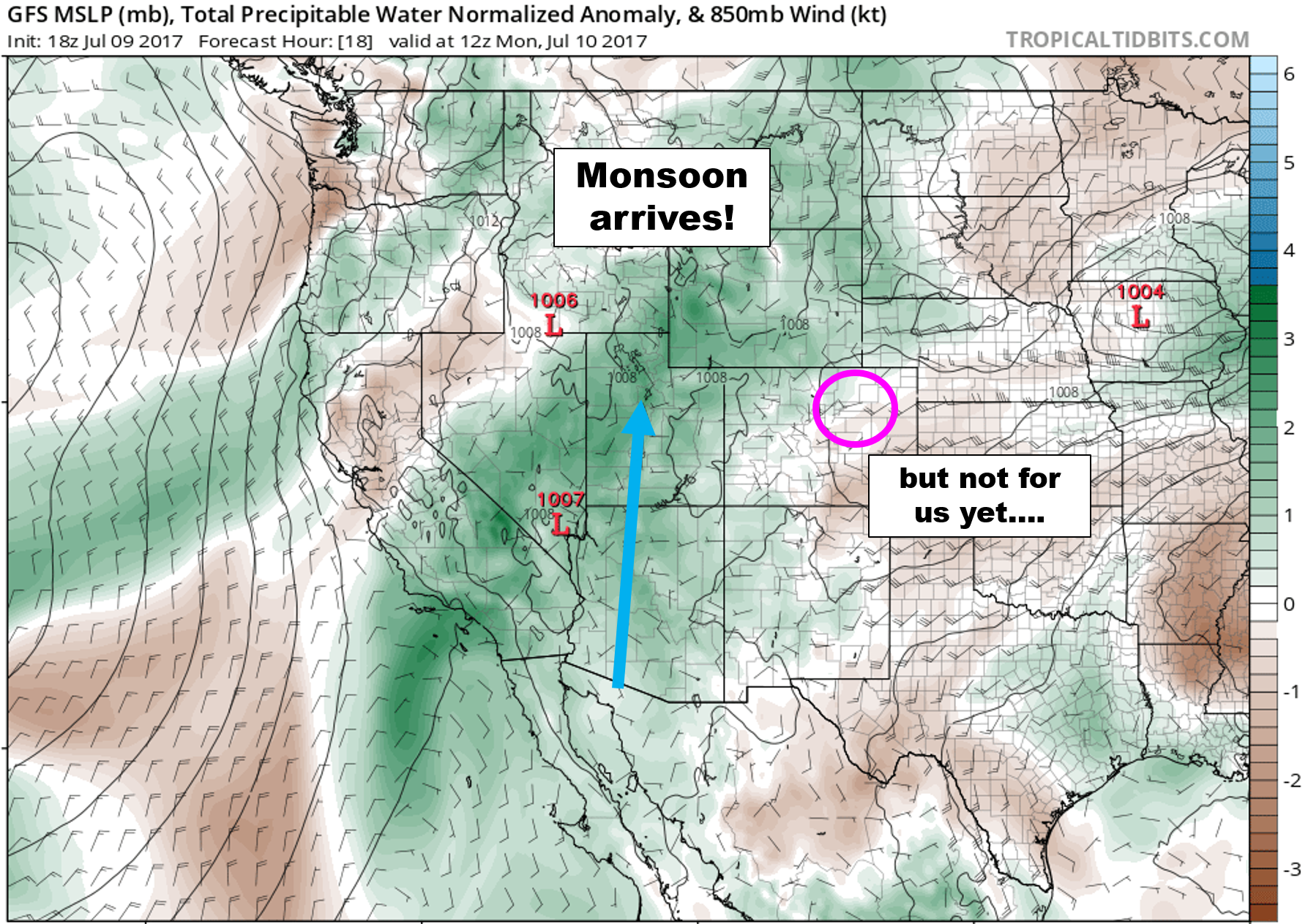
GFS precipitable water anomaly for Monday showing the monsoon moisture plume pushing northward
While the added moisture should reduce the number of dry thunderstorms for the region, we’re not all that convinced it will bring the widespread moisture that we need….but there is some hope!
Despite the “lack” of moisture today, we’ll see widely scattered storms again across the Front Range this afternoon. Storms should initiate over the Mountains by early afternoon and should survive long enough to bring the chance of rain to some locations on the Plains by evening. Highs will be in the middle 90’s…probably our warmest day of the week.
Wetter Tuesday and Wednesday
Moisture increases to Colorado in general by Tuesday afternoon. With this, we’d expect to see a better chance of afternoon showers and storms for the Foothills and Plains. Highs will be a few degrees cooler with the added clouds as well. Rain chances increase even further on Wednesday! We’re not expecting a wash out either day, but your odds of seeing rain look to be higher than they have been for at least the last two weeks, especially between 4PM and 10PM on these days.
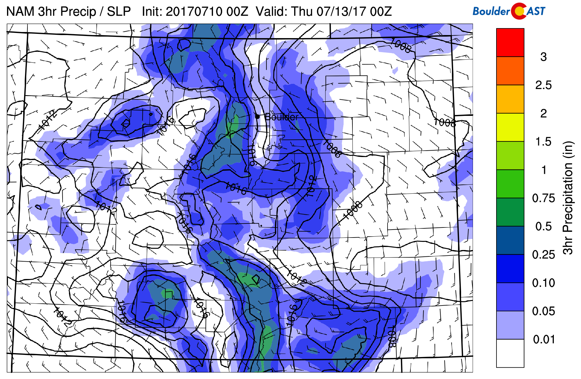
The NAM model projects scattered to potentially widespread storm coverage Wednesday afternoon and evening
Strong ridge will suppress monsoon late-week
The models are projecting a potent summertime ridge to build late-week over Utah and strengthen into the weekend. This is very visible in the 500 mb height anomaly animation below.
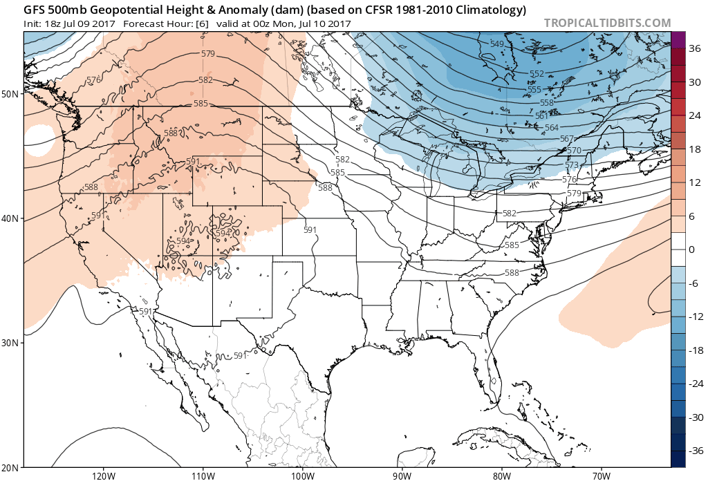
GFS 500 mb height anomaly through Saturday showing the development of a large ridge across across the West.
The clockwise flow around the ridge will direct the monsoon plume further to the west….
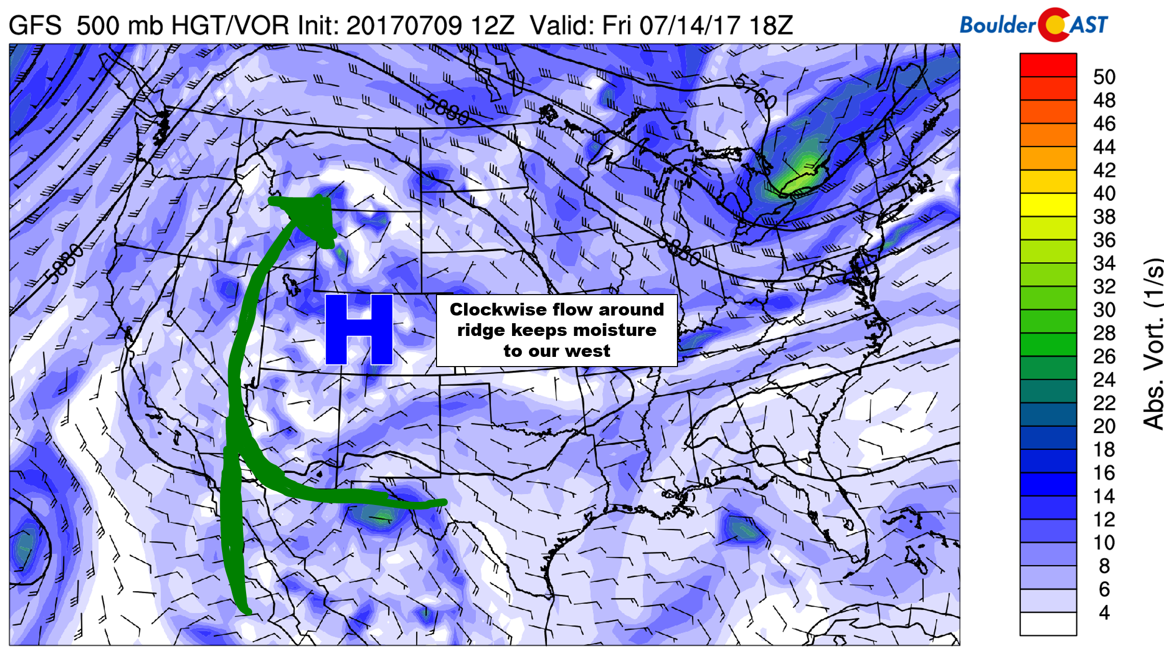
With the ridge axis to our west, the monsoon moisture will also remain to our west
This will likely mean storms chances get reduced Thursday heading into the weekend, and that temperatures will be heating back up. Expect upper 80’s to low 90’s Thursday and Friday with isolated afternoon storms.
Forecast Specifics:
Monday: Sunshine in the morning, with increasing clouds in the afternoon. A few widely scattered storms form during the late afternoon and evening. Best chance of rain will be from 4PM to midnight. Expect highs in the middle 90’s on the Plains, with low 80’s in the Foothills.
Tuesday: Partly to mostly cloudy with scattered afternoon thunderstorms. Highs in the low 90’s across the Plains and upper 70’s in the Foothills.
Wednesday: Slightly cooler with lots of mid and high-level cloud cover. Widespread storms will form across the Foothills, with scattered storms moving west to east across the Plains in the late afternoon and evening. Expect highs in the upper 80’s across the Plains and mid 70’s for the Foothills.
Thursday: Morning sun with partly cloudy skies in the afternoon. Widely scattered storms will be possible, mainly across the higher elevations. Expect highs in the upper 80’s for the Plains and mid 70’s in the Foothills.
Friday: Partly cloudy skies with a slight chance of afternoon storms, particularly across the Foothills south of Denver. Highs in the low 90’s on the Plains and low 80’s in the Foothills.
High Country: We’re expecting dangerous afternoon/evening storms each day this week. They will be scattered in nature Monday, Thursday, and Friday, with widespread coverage Tuesday and Wednesday.
Share our forecast:
Mon
Tue
Wed
Thu
Fri


Temperature
95
92
88
88
92


Precip Chc (Plains)
30%(pm)
30%(pm)
40%(pm)
20%(pm)
10%(pm)


.


