The first few days this week will be quite warm…potentially record setting. Colder air follows midweek with the possibility of snowfall for the Mountains and Plains. We detail this, as well as the extended range forecast through the weekend in which we are tracking Arctic air.
Warm today and near record temps Tuesday
Below shows the mid-level pattern today. High pressure is situated across Southern California. That translates into west-southwesterly winds ensuing at the surface this afternoon. We should be a tad warmer than yesterday in the middle 50’s under a mix of clouds and sun.
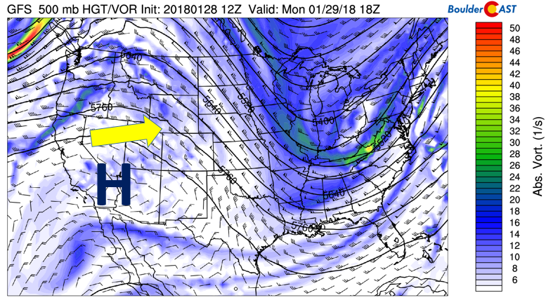
GFS 500 mb absolute vorticity for this afternoon
On Tuesday, we may see near-record temperatures across the Denver Metro area. The airmass warms some 5-6 degrees Celsius from Monday as a result of downslope flow strengthening. The figure below shows a deep area of low pressure will be present across south-central Canada, with a trough axis stretching southward into Eastern Colorado. The warm airmass is visible east of the Divide on the image. Higher up in the atmosphere, the jet stream will be overhead, with strong winds increasing across northern Colorado. As a result of this pattern, highs in the mid to upper 60’s are possible for us on Tuesday. The fly in the ointment will be how much wave cloud action we will see during the day. With relative humidities high in the upper atmosphere, thick wave clouds will likely limit the warm-up. The record high for Boulder on Tuesday is 71 set back in 1986. We’re not projecting temperatures quite this warm for Tuesday.
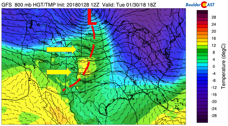
GFS 800 mb temperature, wind, and heights on Tuesday afternoon
There is also the potential for gusty winds across the region Tuesday and Tuesday night with the jet overhead and a mountain wave developing, but confidence is low at this point. Winds will likely be breezy across the Plains, with some gusts in the Foothills approaching 60 mph.
Cold Front arrives Wednesday, snowfall?
On Wednesday, a cold front dips down in the flow as the jet stream shifts into Colorado. The image below is the NAM forecast on Wednesday evening for 800 mb low-level temperatures. Current regional and global-scale models bring the front through Wednesday morning, with colder air filtering in through the day and evening. The airmass will significantly cool from Tuesday – so if you have time to play hookie at work, do so on Tuesday before the cold air filters in. Highs looks to be in the upper 40’s to lower 50’s, then gradually dropping through the day into the 30’s.
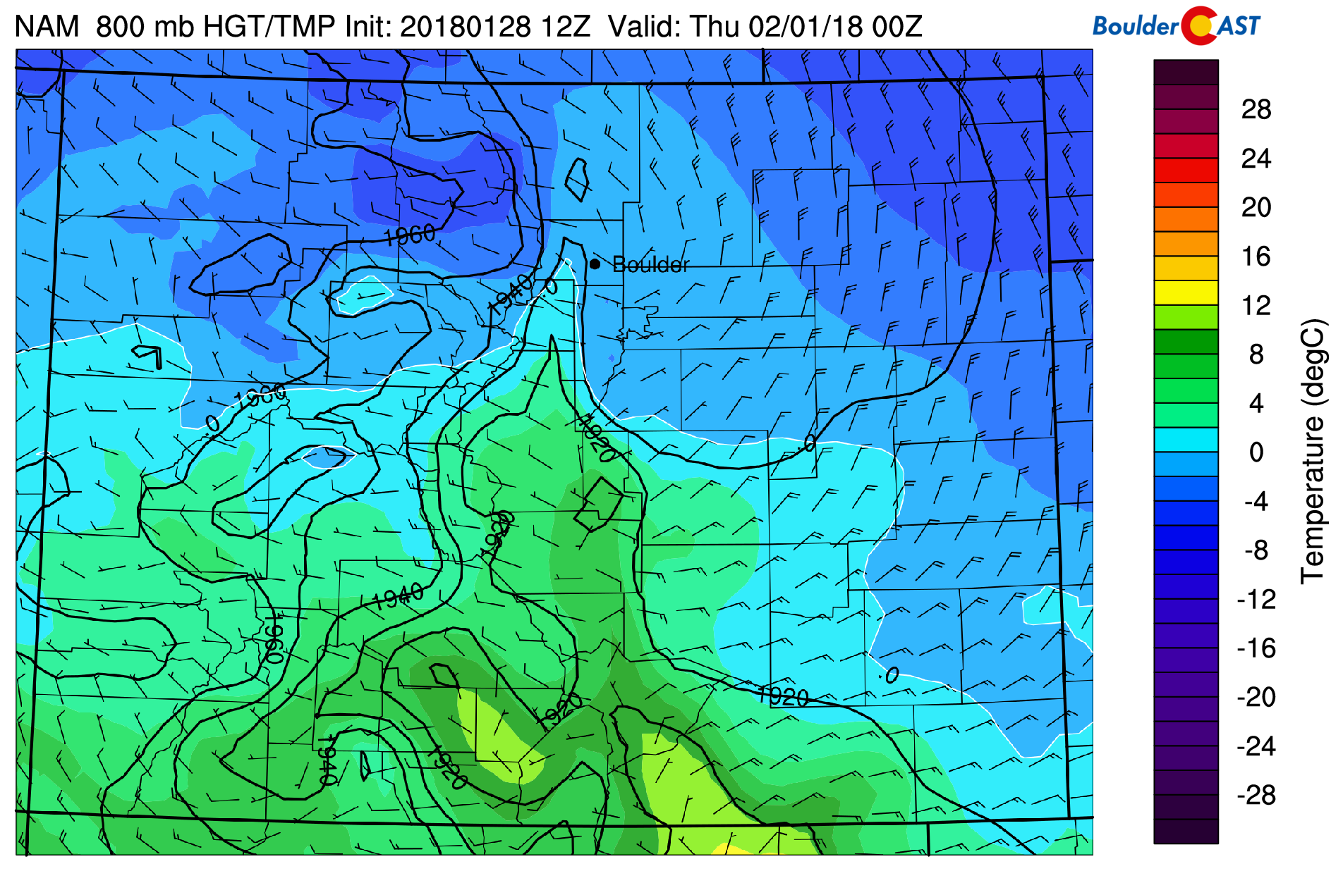
NAM 800 mb temperatures across Colorado Wednesday
The potential for snowfall Wednesday night and early Thursday morning is mainly tied to forcing from the jet stream overhead. However, the global models do not seem to have a good handle on the situation. Some runs of some models put northeast Colorado in the left-exit region of the jet, while others do not. Combined with only weak upslope at the surface, our chances of snow are marginal at best. We will update you as the go through the week, but for now, don’t worry too much about this one.
The cold air will stay with us into Thursday regardless of any snowfall with temperatures remaining in the 30’s to lower 40’s.
Brief warm-up Friday
On Friday, the pattern shifts once again. The jet stream will edge northward into Nebraska and Wyoming. This will help aid in surface downslope across the Front Range. Highs returning into the 50’s are likely.
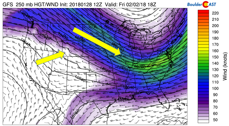
GFS 250 mb jet stream pattern on Friday
Potential Arctic air and snowfall for the weekend
Over the weekend, large uncertainty at the time of this post abounds in regards to a surge of Arctic air making its way southward out of Canada into the United States. We are going to show a few plots below indicating the initial uncertainty, followed by a pattern prediction based on climate indices.
First off, the below image is of the Canadian model 850 mb temperature anomalies on Sunday afternoon. Shown is an Arctic high pressure over the Dakotas, with upslope winds across much of Colorado and well below normal temperatures. This would translate to highs only in the single digits.
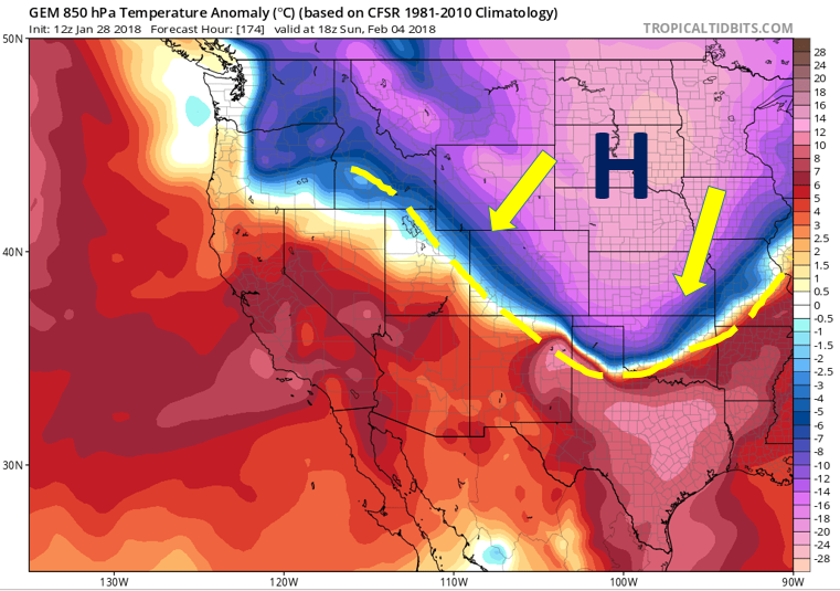
Canadian model forecasted low-level temperature anomalies Sunday
However, the forecast varies by model. The GFS (below) shows a similar pattern, although the high pressure is slightly more westward over far eastern Montana. The GFS with this pattern is indicating snowfall with the Arctic cold front over the Front Range. This forecast would be promising for a light to moderate snowfall event. It should be noted that this 18 UTC run of the GFS shifted the main axis of the cold air further east as opposed to its 12 UTC forecast – thus a trend of keeping the most frigid weather over far eastern Colorado.
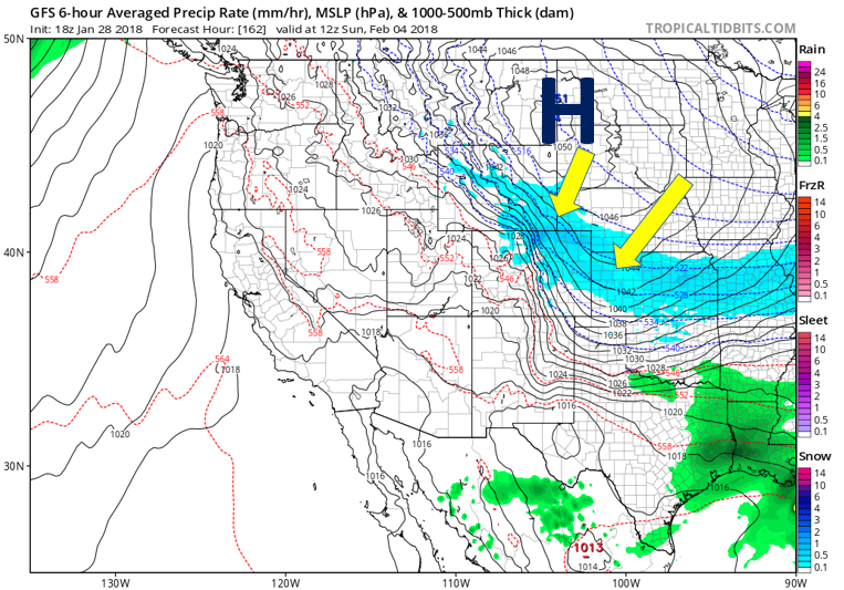
GFS surface pattern and precipitation on Sunday
A polar opposite (no pun intended!) scenario of both the GFS and Canadian models is presented by the European model, shown below. It has a very different pattern, with high pressure over California and warmth overspreading much of the southwestern United States. This pattern would keep the cold air well to our east in the upper Midwest.
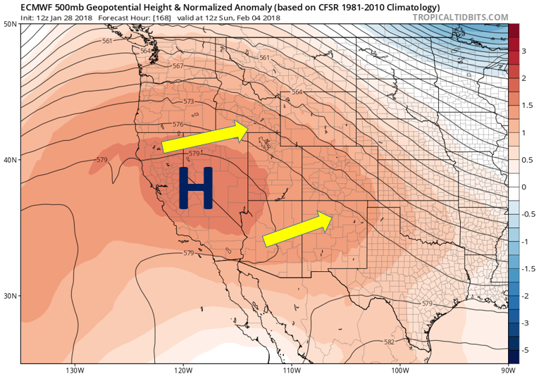
ECMWF model forecasted 500 mb heights Sunday
Obviously, the forecast is not set in stone for the weekend. To dive deeper, we can examine teleconnection patterns over the Eastern Pacific and North Atlantic, which drive much of the atmospheric circulations over the United States. Two of these indices we look at are the Pacific North American (PNA) pattern and the North Atlantic Oscillation (NAO). The PNA focuses on the strength of the Aleutian Low over Alaska, while the NAO focuses on the strength of the Icelandic Low. Below shows the PNA and NAO forecast through February 11th. The PNA is forecasted to be in its negative pattern through February 5th, while the NAO remains in a positive phase. This would point to a weaker Aleutian Low over Alaska and weak troughing over the Western United States from the PNA, while the positive NAO would indicate a stronger Icelandic Low, keeping the bulk of the cold air over the northeastern United States. Thus, a general forecast by examining these indices would support a blend of the 3 models shown above – that is, we will likely see colder air this weekend, but the bulk of the Arctic air would likely reside over the Midwest and Northeast.
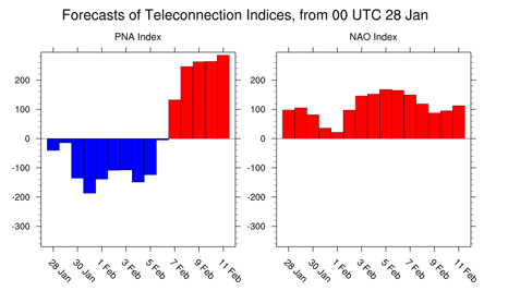
PNA forecast (left) and NAO (left) forecast
This middle-of-the-road forecast is also supported by the GEFS ensemble forecast Friday through next Tuesday. This is shown below. It indicates that the probability of snowfall for the Plains is ~ 50%, a decent chance of getting snowfall with the Arctic front Sunday – though an equal chance as well of being dry – this all hinges on the position of the Arctic intrusion…
Forecast Specifics:
Monday: Partly sunny and mild, highs in the middle 50’s across the Plains, with middle 40’s in the Foothills.
Tuesday: Lots of wave clouds and breezy with west winds of up to 30 mph. Highs in the mid to upper 60’s for the Plains with upper 50’s in the Foothills. Winds may gust up to 60 mph in the Foothills.
Wednesday: Increasing clouds and colder. Highs near 50 across the Plains, and upper 30’s in the Foothills. Temperatures dropping in the 30’s by evening in the Denver Metro with spotty light snowfall possible in the late evening. No accumulation is expected.
Thursday: Isolated light snow possible in the early morning, then mostly cloudy and cold with highs in the upper 30’s over the Plains and upper 20’s in the Foothills.
Friday: Partly sunny and warmer with highs in the 50’s for the Plains and 40’s in the Foothills.
High Country: The mountains will remain dry Monday and Tuesday under high pressure. Light snowfall across the slopes in Eastern Colorado will lead to light accumulations Wednesday and Thursday, with maybe an inch or two of accumulation north of Interstate 70 by Thursday morning. A chance of isolated snow showers are also possible Friday and Saturday with the jet stream overhead. Otherwise, most of the week is dry, with the potential for snow Sunday with a trough approaching. Find the latest forecast for all your favorite Colorado ski resorts on our PowderCAST page.
DISCLAIMER: This weekly outlook forecast was created Monday morning and covers the entire upcoming week. Accuracy will decrease as the week progresses as this post is NOT updated. To receive daily updated forecasts, subscribe to BoulderCAST Premium.

.
Share!


You must be logged in to post a comment.