
Get ready for a cold week! After relatively mild temperatures to end 2016, we’ll see the return of the winter chill along with chances for snow in the first week of the New Year. The mountains can expect to see FEET of snow throughout the week, while snow possibilities on the Plains are less and shrouded in a bit of late-week uncertainty. How cold will it get and what can we expect in terms of snow? Read on for our full forecast.
Trending toward Arctic by late Monday
Our Monday starts off similar to the weekend as downslope flow early ensures highs will reach the mid to upper 40’s. We would not be surprised if some locales in the Denver Metro peak in the low 50’s. Leaving work will be another story, however! Below shows the upper-level pattern for today. Notice a large area of low-pressure over the Pacific Northwest. Accompanying this is a stream of Pacific moisture (orange arrow) pumping into the southwestern United States and Colorado. This moisture will be a sizable player through the week for heavy Mountain snowfall and the chance of snow on the Plains several days.
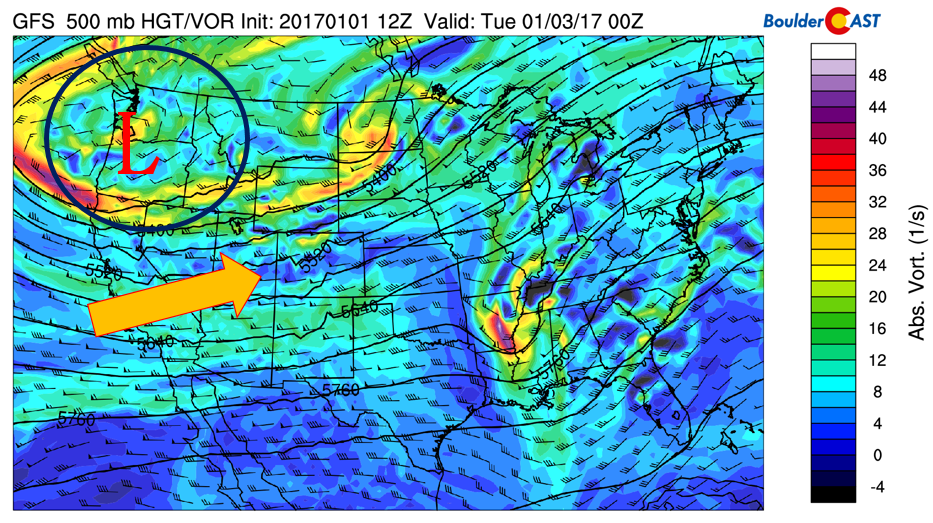
GFS model upper-level pattern today. Arrow indicates Pacific moisture stream
At the surface, an Arctic cold front will make its way southward out of Montana into northern Colorado by mid-day Monday. Below shows the position of the front across the United States by early evening. The front will be knocking on the doorstep of the Plains at this point…
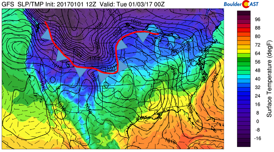
GFS surface temperature, sea-level pressure, and wind for today. Red line and blue arrows indicates arctic cold front
A closer inspection of the front is given below, centered on Colorado. The red line and blue arrows indicate the front’s position as of 5:00PM this evening. After a quick warm-up at mid-day, temperatures will drop into the 20’s behind the front between 5 and 7PM. So be sure to bring those winter coats if you’re heading to work today.
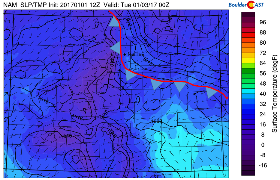
A closer look at the arctic front moving through this evening across Colorado
What about snowfall? The Mountains will certainly see some, and it’s already falling this morning. Expect a bump in the intensity tonight and tomorrow, with several places seeing anywhere from 3-8″ across a range of ski resorts. For a more detailed ski outlook, check out our frequently updated PowderCAST page. The Mountain resorts will likely see more-or-less continuous snow throughout the week with that plume of moisture from the Pacific Ocean staying in place. In the end, this will amount in 1 to 3 feet for many Mountain locations by Saturday.
Colorado won’t be the only place benefiting from the Pacific moisture. Below shows the accumulated liquid precipitation forecast through Friday from the GFS. Northern California and the Sierras are slated to see anywhere from 4-6″ of liquid precipitation, with snowfall amounts possibly of 2 to 5 feet!
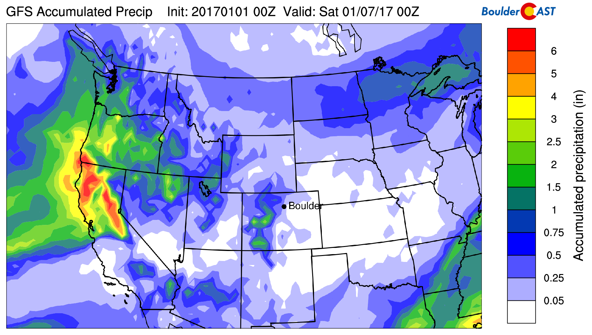
GFS total accumulated liquid precipitation through Friday
Closer to home, the total snowfall from tonight into Tuesday afternoon from the GFS (left) and NAM (right) forecast models are shown below. For the Plains, the GFS indicates the potential for up to 2″ north of Boulder into Ft. Collins, while the NAM keeps all snowfall over the High Country. Definitely some disagreement…
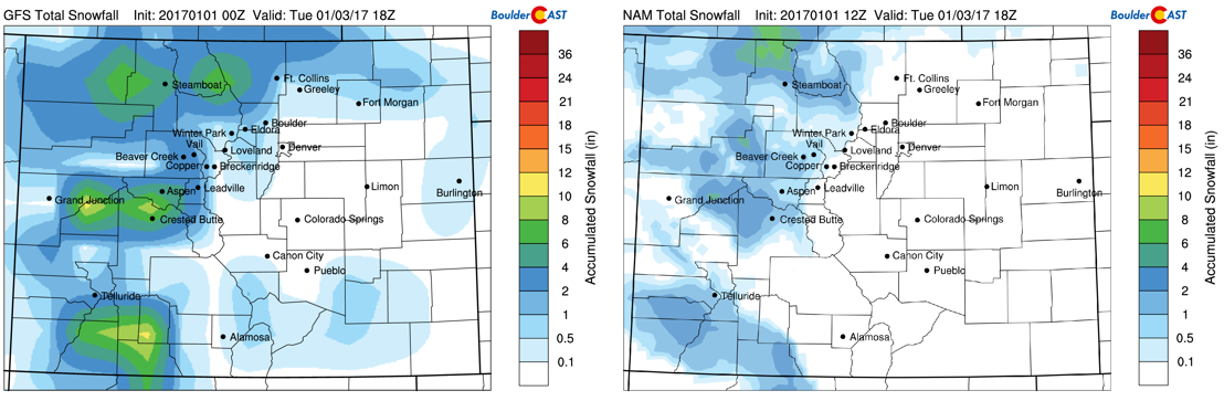
GFS (left) and NAM (right) snowfall tonight into tomorrow afternoon
The chance of snow on the Plains is due to the Pacific moisture plume and an upper-level jet streak (indicated in red below). The blue arrow indicates that due to the approaching jet streak, northeastern Colorado is in a region of atmospheric lift and this could support isolated heavy snow bands across northeastern parts of the state (remember that heavy snow band in Denver a few weeks ago?). It’s difficult to tell where these bands, if at all, would set up, but the potential is there we could see up to 2″ over the Plains north of Denver by Tuesday afternoon. Any snow would start after midnight tonight.
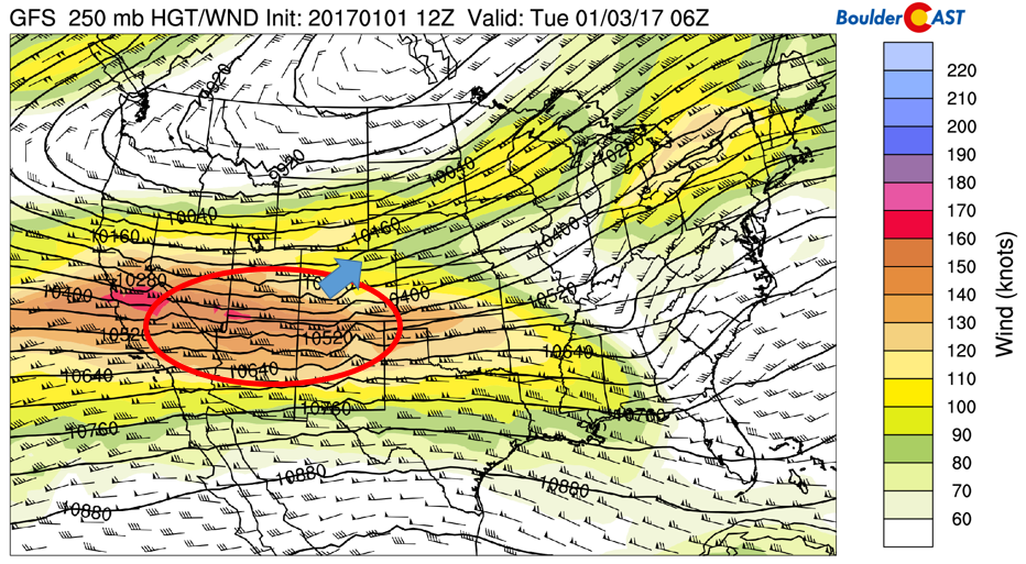
GFS upper-level jet streak pattern for tonight. Arrow indicates region of lift for potential banded snowfall
Tuesday just plain cold with light snow possible
On Tuesday, the frigid air will be well-entrenched across the region. Highs will struggle to get out of the 20’s on the Plains. With cloud cover likely throughout much of the day and the chance of morning snow. Needless to say, this all points to a cold day. Meanwhile, the mid-levels of the atmosphere (below) will continue to see westerly flow with weak systems trekking from west to east over the state, pounding the ski resorts with additional powder. Gusty winds are likely in the High Country if you’re going out skiing or hiking.
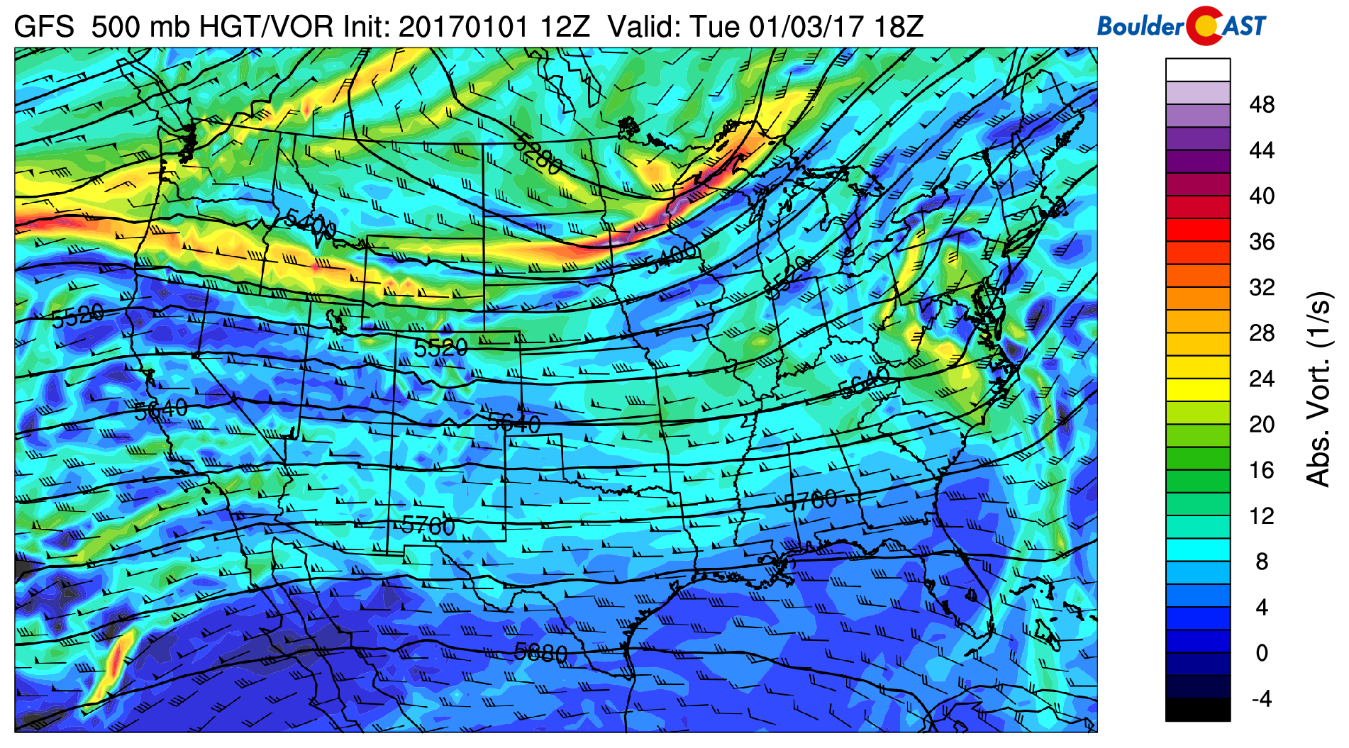
GFS mid-level pattern for Tuesday
Second arctic intrusion on Wednesday…a better chance of snow?
A second arctic intrusion will likely move through the forecast region Wednesday afternoon/early evening. Below shows the United States surface temperatures for Wednesday night. Note that much of the country will be below freezing, even down to the Gulf Coast, which speaks to the strength of this second Arctic push. There are differences, however, in how the models handle this second wave of cold air. The Euro model is much colder than the GFS. Given this, we have decided to simply mention the general pattern. Expect middle 20’s on the Plains Wednesday, but then dropping temperatures overnight into Thursday morning with single digits in most areas. A shortwave will also be pushing through Wednesday and the models are indicating the potential for another round of snow for the Plains, but confidence on this at the moment is not high; additionally, the pattern will continue to favor heavy mountain snow…10 to 20″+ of white stuff will fall Wednesday through Friday.
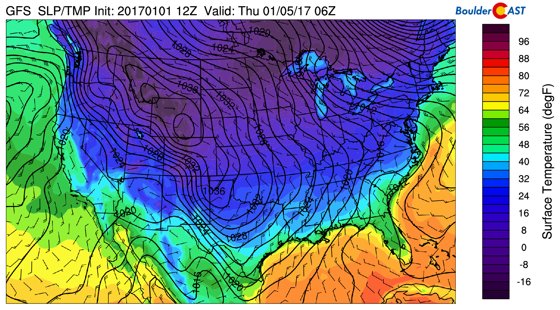
GFS surface temperature, sea-level pressure, and wind for Wednesday night
On Thursday, with the second push of cold air slated to move in, highs will likely again be in the lower 20’s, but could be colder if the airmass pushes further west than currently advertised by the models. This will probably be our coldest day of the week.
Friday and weekend slightly warmer but still wintry
On Friday, the models remain in disagreement as well. The uncertainty is focused around a cut-off disturbance that might get swept across the northern Rockies Friday. It’s somewhat subtle and the models are, of course, all over the place with it. However, some runs do show the potential for more snow, including moderate to heavy snow for the lower elevations as a surface low forms. We’ll need to watch this system as the week progresses. For temperatures, Friday should begin to warm-up ever-so-slightly. However, as with most shallow Arctic air masses, they are often slow to retreat. As a result, upper 20’s or 30’s may be possible Friday but confidence this far out is not as high.
As we go into the weekend, the ridge builds in but this does not last long as a series of Pacific storms return which will again bring snow to the High Country. The first could arrive Sunday. The chance of snow for the Plains looks low over the weekend and early next week at the moment, but things can certainly change between now and then. Enjoy the snow and stay warm!
So in summary…
Yes, it’s going to be a chilly week. Boulder and Denver may remain entirely below freezing from Monday evening into the weekend. Chances of snow on the Plains will exist nearly every day as well. The Mountains for sure will see significant snow. There is a lot going on this week, and that makes us a little nervous for things to change, particularly from late Wednesday into Friday where model disagreement is uncomfortably high surrounding a potential snow event or two. Stay tuned through the week. We’ll post updates, as needed.

Forecast Specifics:
Monday: A mix of clouds and sunshine early, turning to increasing clouds later in the day. Highs early in the day in the mid to upper 40’s. Temperatures dropping by early evening into the 20’s and teens overnight. Light snow possible overnight with a trace up to 2″ over isolated areas of the Plains north of Denver. In the Foothills, highs in the low 30’s with up to 3″ of snow overnight.
Tuesday: Mostly cloudy skies with light snow possible in the morning and early afternoon. Temperatures in the mid 20’s on the Plains and low teens in the Foothills.
Wednesday: Mostly cloudy with highs in the middle 20’s for the Plains and middle teens in the Foothills, then turning colder later in the day and evening with single digits overnight into Thursday morning for the Plains and Foothills. Snow is possible Wednesday afternoon, evening and night, but confidence at this point not very high. Some models are showing significant snow for the Foothills and lower elevations.
Thursday: Overcast with a chance of snow for everyone. Models are indicating the potential for some significant snow. We’ll be tracking this closely through the week. Highs in the lower 20’s on the Plains and low teens in the Foothills. Temperatures could be colder if the Arctic air mass is stronger than currently expected.
Friday: Warmer but still wintry with highs upper 20’s for the Plains and upper teens in the Foothills under mostly sunny skies. We can’t rule out more snow this day either.
High Country: A great week for skiing as snow is expected almost every day this week. The first batch of snow comes tonight into Tuesday and Tuesday through Thursday. Snow again possible on Friday but confidence on Friday not as high as earlier in the week. Several feet of snow are possible by the end of the week with very cold temperatures and blustery conditions.
Extended: The extended outlook shows slightly moderating temperatures into the weekend and early next week. However, another period of wintry weather may be possible Sunday into next Monday, though confidence in the long-range not very high. At the least, it should be a tad warmer next week.
Mon
Tue
Wed
Thu
Fri


Temperature
46
26
24
21
30


Precip Chc (Plains)
20%(pm)
20%
30%
40%
30%


You must be logged in to post a comment.