The week ahead starts out on the cold and wintry side on this M.L.K. day. The Arctic air doesn’t last long however, as warm air spreads back into the area by Wednesday. We are watching the potential for a more potent winter storm late in the week and coming weekend. Read on for more details.
Snowpack below normal as of mid January
Before discussing the week ahead, we thought we’d touch base on the current snowpack across the state. The figure below shows the current SNOTEL snow water equivalent (SWE) as of January 14th, 2018. The majority of the state is experiencing below normal snowpack in general, with a mean SWE of 63%. However, some regions are seeing well below average, such as southwestern Colorado, where the SWE is as low as 34%. For the Denver Metro Area (the South Platte River Basin), we are slightly below average at 88%. We certainly could use a pattern shift to whiten-up the High Country. More on that later…
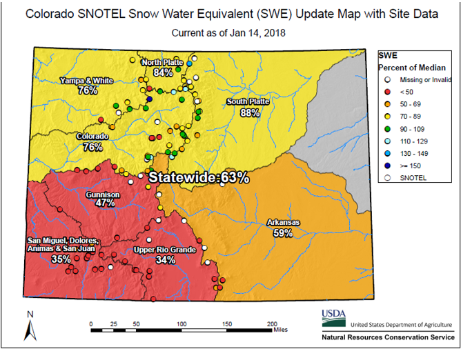
Current snow water equivalent across the state of Colorado
Cold and wintry to start M.L.K. Day
On this day, we celebrate the great Dr. Martin Luther King Jr., and his fight for civil rights regardless of skin color, race, etc., most especially African Americans who were victims of racism in the mid 20th century. While things have improved since his passing, we are reminded on this day that everyone should be judged “not by the color of their skin, but by the content of their character.”
Below shows today’s mid-level pattern across the nation. An elongated and large Arctic low pressure system is positioned over southern Minnesota. Around the base of this trough is a pocket of very cold air, influencing much of the mid-section of the country, including Colorado.
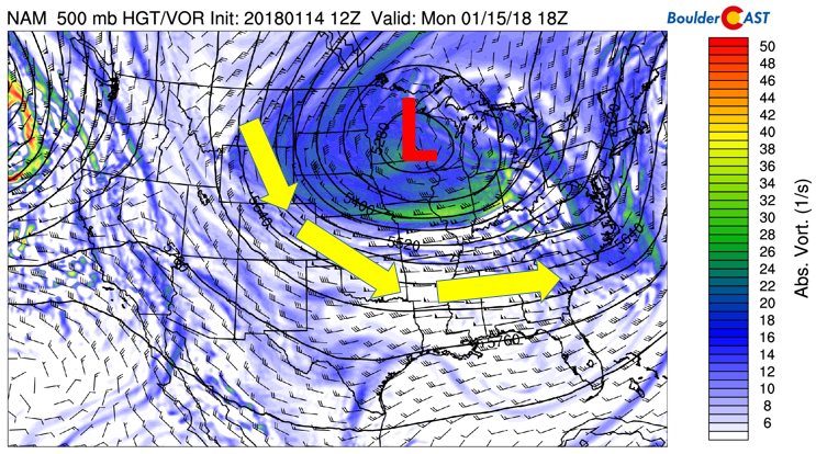
NAM 500 mb absolute vorticity this afternoon
At the surface, this pattern has brought sub-zero temperatures across the Midwest. In northeast Colorado, it’s not quite that cold, but we are under northeasterly upslope flow. This will allow the Arctic air to continue to filter in through the day. Light snow has started this morning and will persist into early afternoon. The upper-level forcing from the jet may not make it far enough southwest to impact Boulder and Denver. The resulting shallow upslope will produce freezing drizzle in locations where the cloud deck is shallow and forcing is minimal.
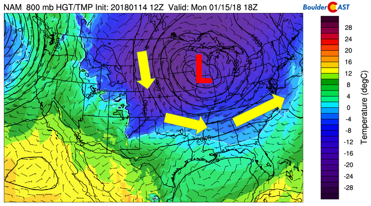
NAM 800 mb surface temperature today
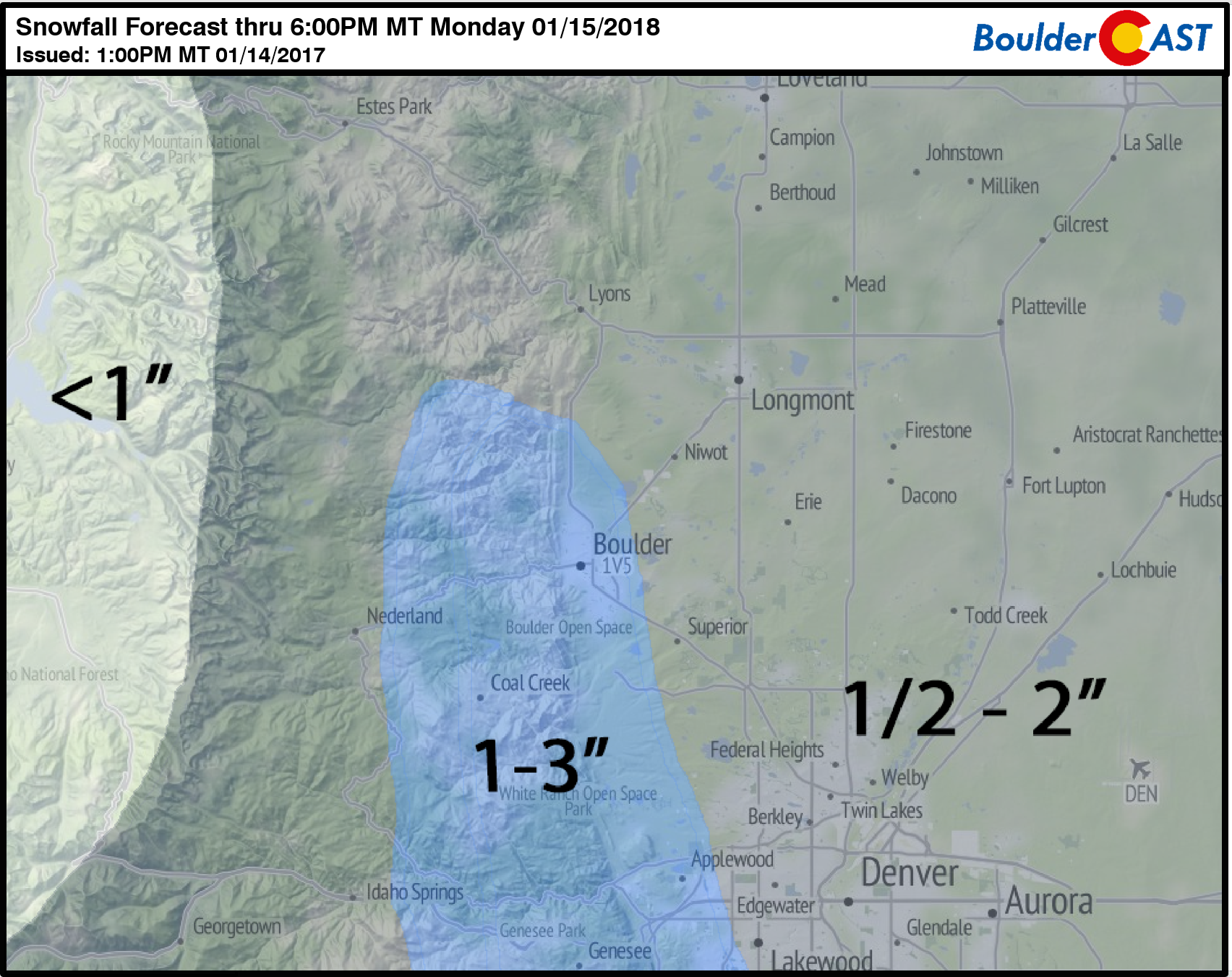
We are expecting snow totals of 1 to 2″ for most of the Denver Metro area (up to 3″ in isolated locations impacted by heavy snow bands), along with a thin coating of ice in western and southern Denver and Boulder. The clouds will remain in place through the day with temperatures dropping from the 20’s into the teens.
Cold and Sunny on Tuesday, moderating Wednesday
On Tuesday, the Arctic trough will slide ever-so-slowly to our east into Missouri (bottom left panel). The slow movement means that eastern Colorado will still be under its influence, with weak upslope flow much of the day. The cold air will retreat somewhat in the afternoon, yet not enough to get us out of the 30’s.
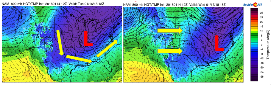
NAM low-level temperatures for Tuesday and Wednesday
By Wednesday, the trough pushes fully to the east into Virginia. In its wake, westerly downslope winds will take over (top right panel). This will create surface warming with temperatures rebounding back into the lower 50’s Wednesday. Wednesday’s mid-level pattern (below) also shows weak ridging, lending to lots of sunshine, although the passing wave cloud can’t be ruled out. Overall, a nice day for the middle of the week.
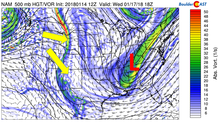
GFS 500 mb absolute vorticity for Wednesday
Mild temperatures continue Thursday and Friday
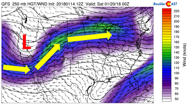
A continued warming of the airmass from Wednesday looks to be ensue for both Thursday and Friday. The figure below shows the upper-level jet stream pattern on Thursday, with the polar jet exhibiting a horseshoe shape, stretching from northern California, traversing into Montana, and bypassing Colorado into Nebraska and Iowa. While the bulk of the jet is north of the state, its close proximity will increase the upper-level moisture, such that wave clouds may develop. We should see upper 50’s to middle 60’s across the region – though it may be hindered somewhat depending on the extent of high clouds present then. Although not impacting us, the figure also shows a clear location of the subtropical jet, across Florida and the Gulf of Mexico.
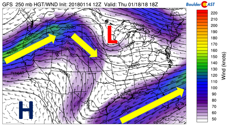
GFS 250 mb upper-level jet stream pattern Thursday
On Friday, general consensus in the forecast models are showing a trough of low pressure moving onshore across California (see below). In connection with this, the polar jet stream makes a transition to shift back southward into Colorado come Saturday. But for half of the day, we should expect another mild day as the jet position will be north and west of the Plains, keeping the cold air at bay. Increasing clouds with the jet stream getting closer should keep temps in the similar to Thursday…near 60 degrees.
GFS 250 mb upper-level jet stream pattern for Friday
A potential winter storm this weekend
We are watching the potential for a more measurable snow storm Saturday into Sunday. Below shows the GEFS ensemble mean forecast of sea level pressure (anomaly shaded) and the ECMWF ensemble mean of sea-level pressure and surface temperature. The models are actually quite consistent that the trough over California Friday will push to our south into southeastern Colorado on Saturday, with cold air oozing in to increase the threat of snowfall.
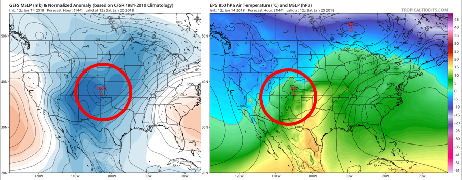
GEFS (left) and ECMWF (right) mean ensemble forecasts for Saturday
In addition, given that the current track will be a southern system, that means it may be able to tap into more moisture from the southeastern Pacific Ocean (see below). Sunday’s GFS deterministic forecast showed a plume of higher moisture pushing into Arizona from the Pacific.
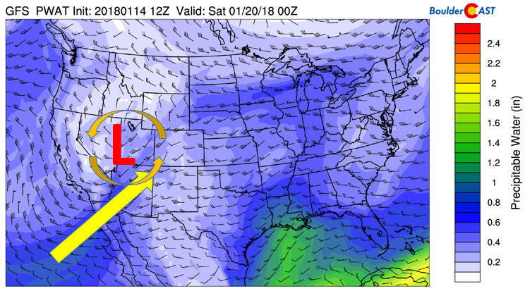
GFS precipitable water forecast for Saturday morning
Although it looks promising, we are still five days out, so the details will likely change. Nevertheless, the mean GEFS snowfall shows 3-5″ potential for the Plains. The track also would bring beneficial snowfall to the High Country, so stay tuned and keep your fingers cross for snow!
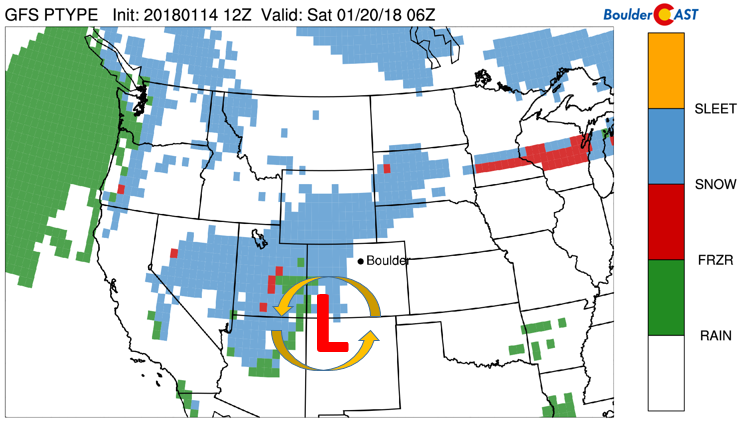
GFS precipitation type forecast Saturday
Forecast Specifics:
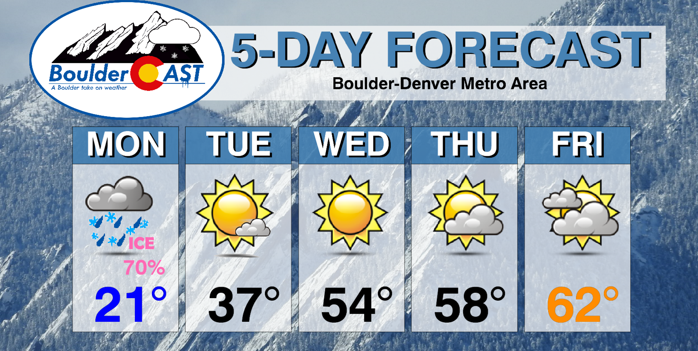
Monday: Overcast and cold with light snow and freezing drizzle during the morning and early afternoon. Snow accumulations of up to 1″ possible. Temperatures falling from the lower 20’s into the upper teens by late afternoon. As for the Foothills, expect temperatures in the teens falling into the single digits by evening.
Tuesday: Mostly sunny and chilly under light east-southeast winds. Highs in the middle 30’s for the Plains with middle 20’s in the Foothills.
Wednesday: Lots of sunshine, but a few passing high clouds cannot be ruled out. Highs in the mid to upper 40’s over the Plains, and middle 30’s in the Foothills.
Thursday: A mix of clouds and sunshine thanks to some high clouds streaming in from the north and west. Mild with highs near 60 degrees across the Plains and upper 40’s in the Foothills.
Friday: Mostly cloudy and warm. Expect highs in the low to middle 60’s for the Plains, and in the low 50’s for the Foothills.
Extended: Extended range model forecasts are pointing to the potential for a winter storm to impact the area Saturday into Sunday. The current trend shows the potential for 3-5″, although the details will be fine-tuned as we progress through the week. Cold air looks to take over behind the system into next week.
High Country: Monday’s snowfall will be confined to the eastern Foothills and Plains. The Mountains will be missing out. Dry weather then persists through the rest of the week, with the next potential snow-maker for the ski resorts looks to dump powder Friday night through Sunday morning. Find the latest forecast for all your favorite Colorado ski resorts on our PowderCAST page.
DISCLAIMER: This weekly outlook forecast was created Monday morning and covers the entire upcoming week. Accuracy will decrease as the week progresses as this post is NOT updated. To receive daily updated forecasts, subscribe to BoulderCAST Premium.

.
Share!


You must be logged in to post a comment.