
After a gorgeous weekend with temperatures across the Plains in the upper 50’s and lower 60’s, the week starts off rather uneventful with conditions similar to yesterday. However, things will be changing, mainly in the department of gusty downslope winds several days this week. This spells out continued above normal temperatures for the Plains, but upslope flow and snowfall for the High Country. Read on for our full weekly outlook of what to expect.
Gusty and warm to begin week
The plot below shows that we will be to the east of a strong upper-level jet which is over Arizona and California. This jet will be a player tonight through Wednesday with gusty winds on the Plains and Mountain snowfall.
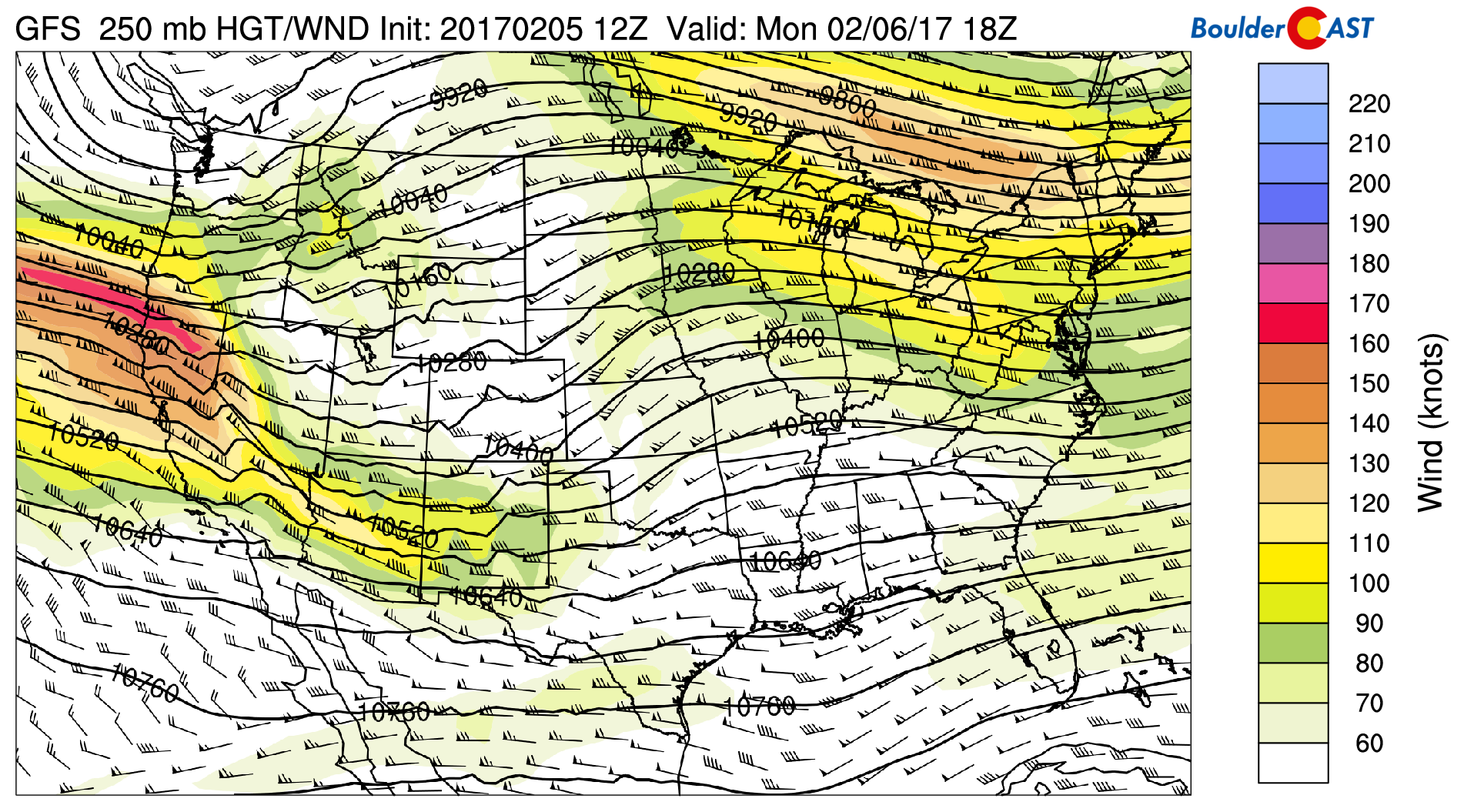
GFS 250 mb upper-level flow for this afternoon
Downslope flow today with west winds gusty at times up to 30 mph will result in us being a tad cooler than Sunday’s highs. We’re expecting upper 50’s across the Plains.
By Monday night, the focus turns to the approaching jet stream, which will push in a shortwave from the west and weak shallow upslope flow…just enough for temperatures to drop close to the freezing mark. With that, the models are showing a hint of snowfall and rain mixing into the area late tonight into early Tuesday. With above freezing ground temperatures from the recent warmth, we are not expecting any accumulations for the Plains. As for the High Country, several ski resorts can expect in excess of 6″, with spots seeing over 12″ of fresh powder by Wednesday morning.
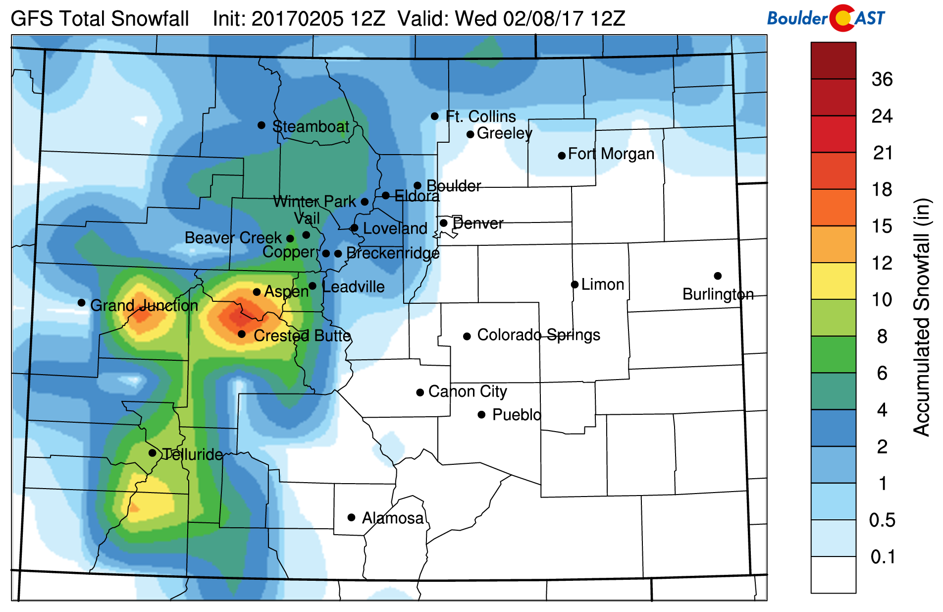
GFS total snowfall by Wednesday morning
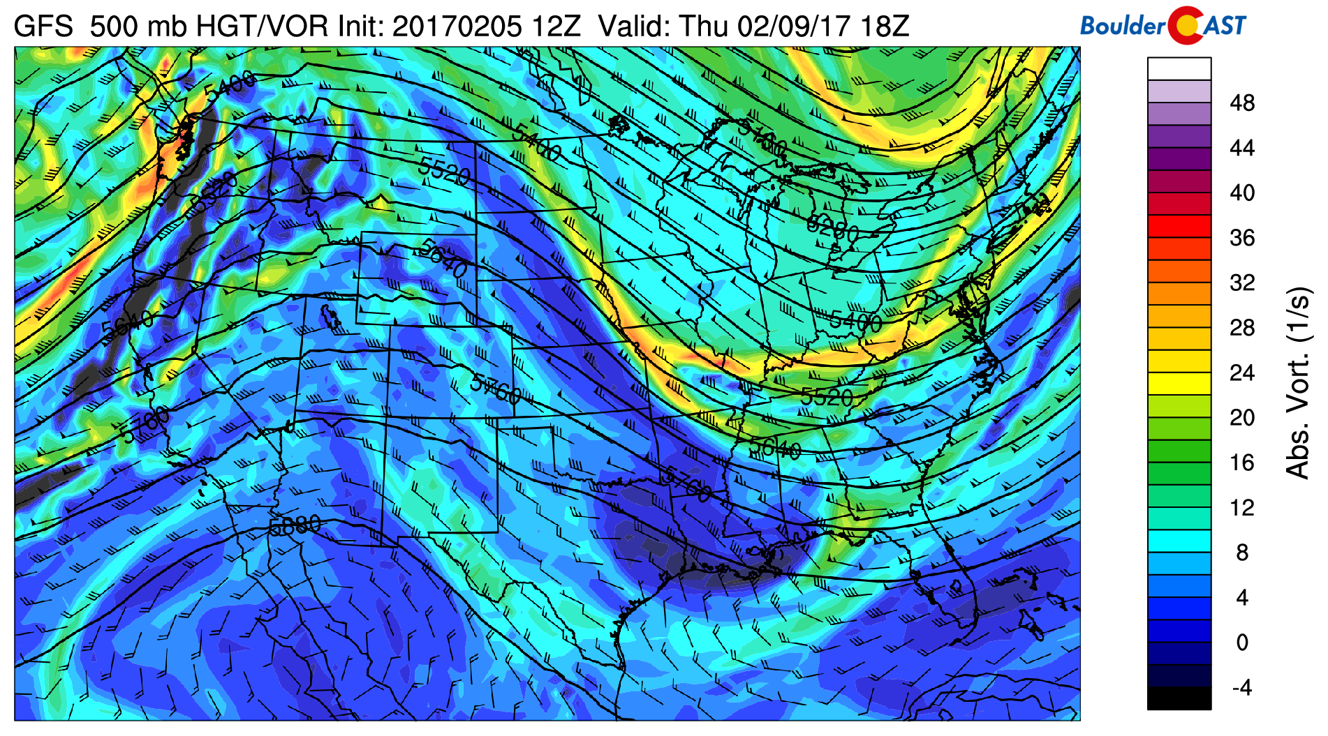
On Tuesday, the jet stream will be right overhead of Colorado. This is evident in the figure below. That will help push a very weak cold front towards the region from Wyoming on Tuesday. Models continue to struggle with the reach of the front that will be knocking on the door during the day. However, we think westerly winds will win out to keep the front at bay, allowing our temperatures to rise into the low 60’s with winds gusting to 45+ mph.
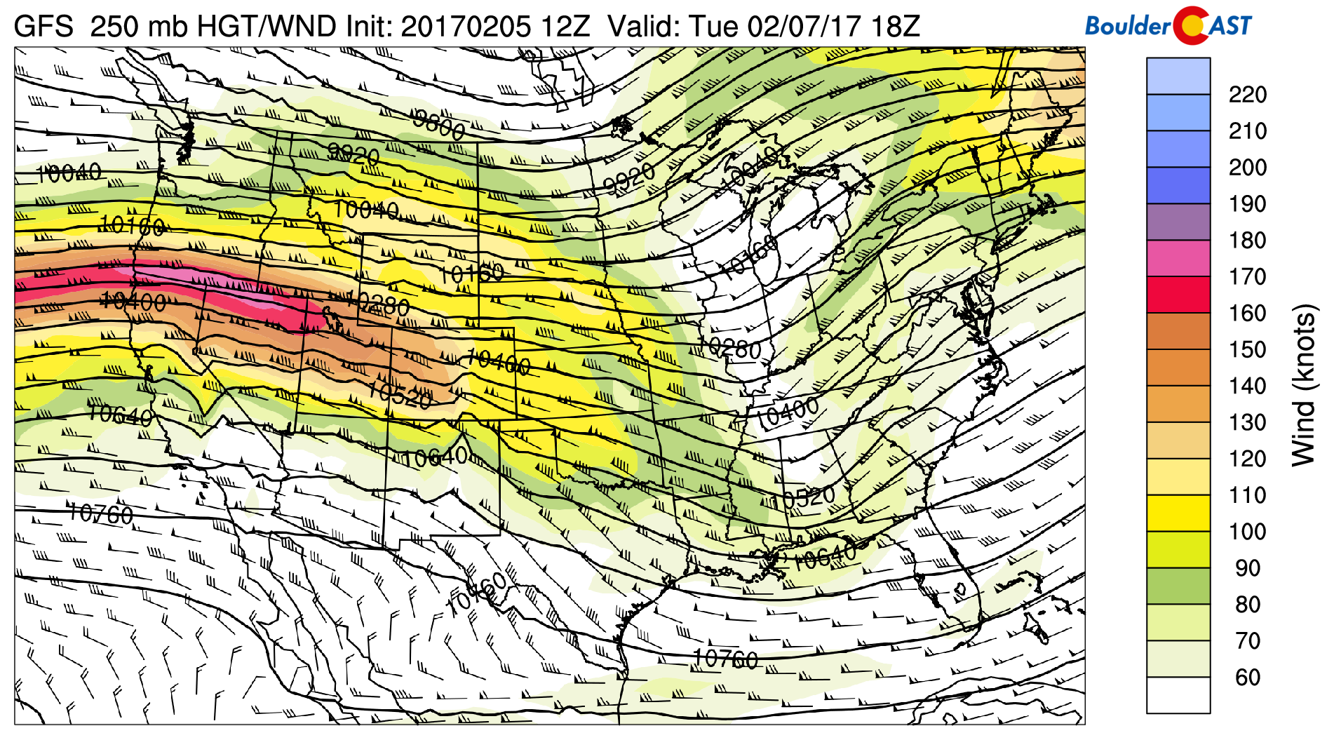
GFS 250 mb upper-level atmospheric flow for Tuesday
Strong northwest winds in the upper-levels of the atmosphere exceeding 160 mph will aid in several periods of heavy snowfall in the High Country on Tuesday. On the Plains, the position of the jet will aid in weak upper-level lift for a slight chance of rain Tuesday during the day and a rain/snow mix Tuesday night.
Below shows the GFS accumulated precipitation by Wednesday morning. It is depicting up to ~ 0.2″ for portions of the nearby Foothills and Plains.
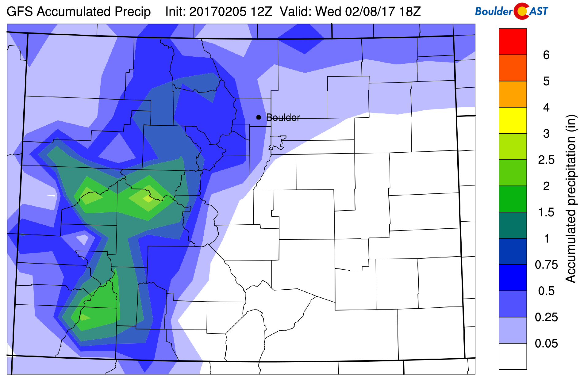
GFS accumulated precipitation by Wednesday afternoon
How much of this is snow? Below shows the GFS model accumulated snowfall through Wednesday. The airmass is not cold enough to support snow on the Plains. Thus, our forecast calls for up to 3″ in the higher Foothills with 6-12″+ in Eldora. Further north towards the Wyoming border, a light dusting of snow will be possible (from Ft. Collins to Cheyenne) as temperatures will be colder and upslope stronger there. In the Denver Metro, we’ll be under the gun for a few light rain showers Tuesday evening and night, especially closer to the Foothills as a few showers roll off the Mountains. Downslope will prevent them from propagating too far eastward.
The main snow producer will be found in the Mountains once again. This is all thanks to the upper-level jet overhead! When all is said and done, 1 to 2 feet of snow is likely across the High Country near and west of the Divide. Certainly a great week for skiing and fresh powder. Be sure to get the latest ski updates on our PowderCAST page!
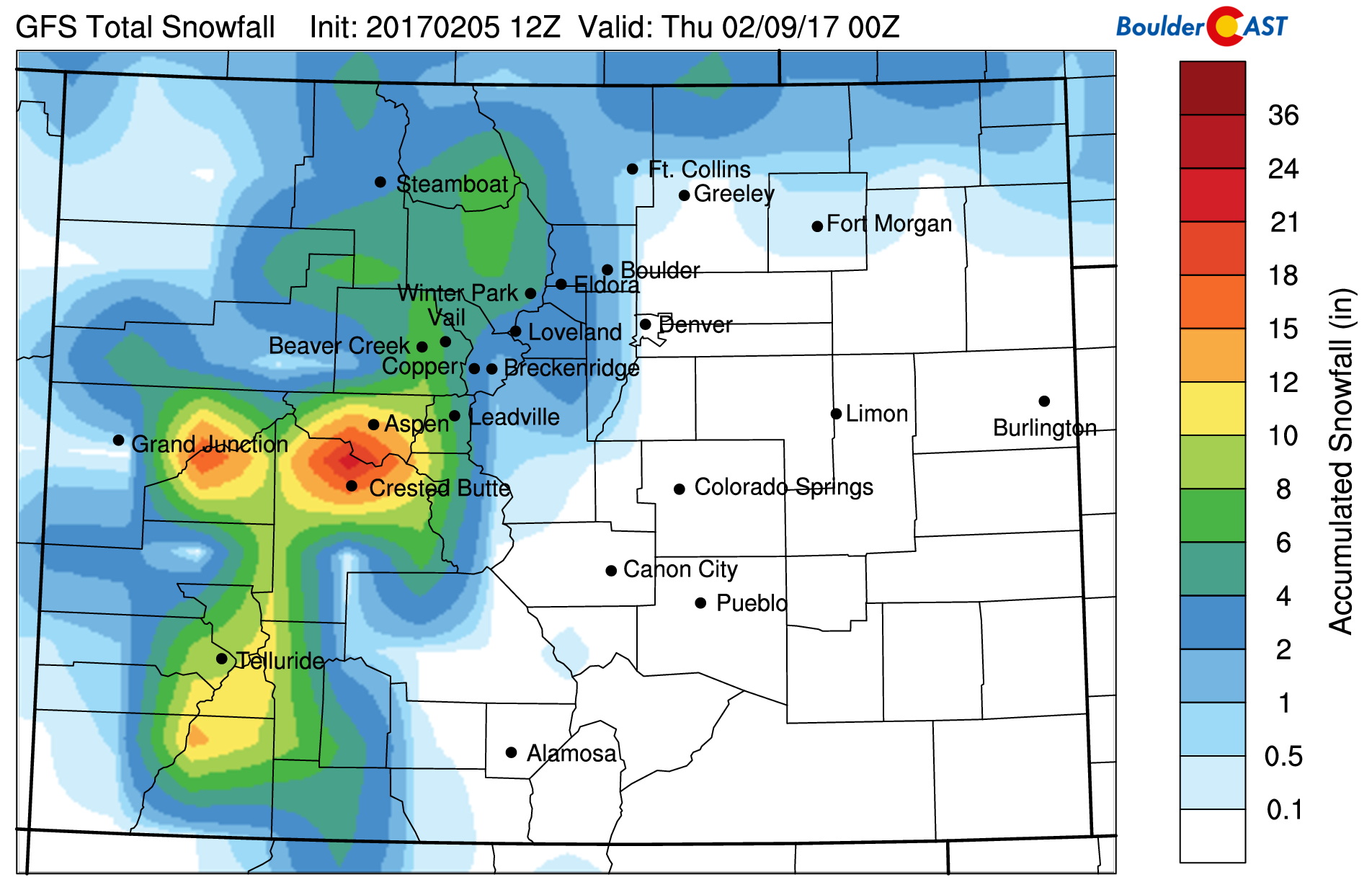
GFS total snowfall through Wednesday
Windy and dry Wednesday
Wednesday will be quite windy, starting as early as Tuesday night with the approach of the secondary part of the upper-level jet stream. This time, the jet will advance further south and be oriented more west-east. This orientation will allow for prime downslope flow and allow west winds to potentially gust over 60 mph Tuesday night and during the day/evening on Wednesday. It’s difficult to pin down the exact timing of the wind two days out, but be on notice that Wednesday could be quite windy with highs in the middle 50’s.
Thursday and Friday are warm, mountain snow returns
Thursday and Friday are much warmer as a result of the downslope pattern. Below shows the mid-level atmospheric flow on Thursday. Also in place will be a ridge of high pressure, aiding in highs once again reaching the lower 60’s. Depending on the exact strength of this ridge, middle 60’s are not out of the question.
GFS mid-level flow for Thursday
On Friday, the pattern shifts once again. While we should remain dry on the Plains and above normal with highs possibly in the middle 60’s, the Mountains will see a return to snowfall. The reason for this is a shortwave trough from the southwest punching into Colorado. That could ultimately lead to another round of 6+” of snowfall in the High Country, which would continue into the upcoming weekend.
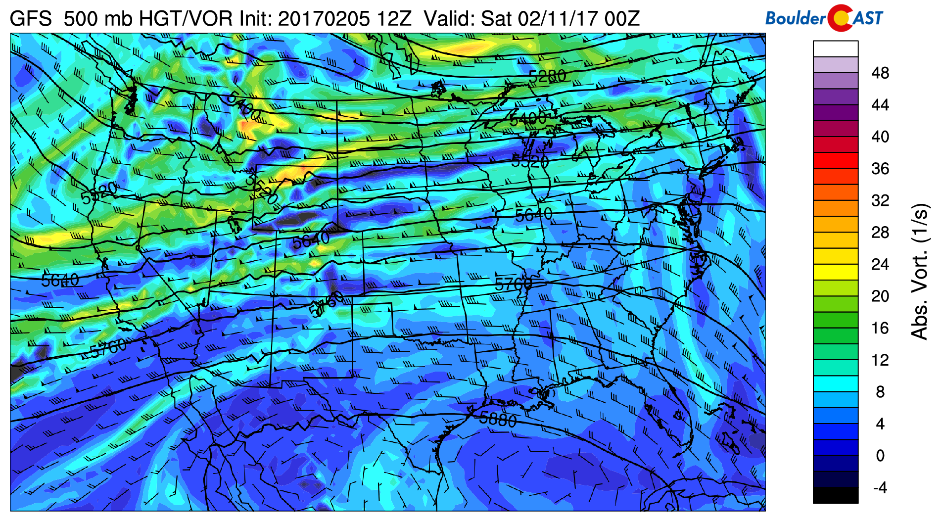
GFS mid-level flow for Friday
Forecast Specifics:
Monday: Partly sunny skies. High temperatures in the upper 50’s on the Plains and lower 50’s in the Foothills. West winds of 15 to 20 mph with gusts to 30 mph. A slight chance of rain/snow overnight but no snow accumulation expected.
Tuesday: A chance of rain showers in the morning and evening under mostly cloudy skies. Windy with gusts exceeding 45 mph at times. High temperatures in the lower 60’s on the Plains and upper 40’s in the Foothills. In the higher Foothills, snow will be possible with up to 3″ in the highest Foothills. Gusty winds continue into Tuesday night.
Wednesday: Windy and mild under partly sunny skies. Highs in the middle 50’s on the Plains and middle 40’s in the Foothills. West-northwest winds at times exceeding 55 mph.
Thursday: Mostly sunny and warmer still with highs in the lower 60’s for the Plains and lower 50’s in the Foothills.
Friday: Highs in the middle 60’s for the Plains and middle 50’s in the Foothills under partly cloudy skies.
High Country: Mountain snowfall expected starting tonight and continuing through Wednesday afternoon. A total of 1-3 feet of snow is possible across several ski resorts. A break in the snowfall then takes over Thursday, with a return a potential second round of snow Friday-Sunday.
Mon
Tue
Wed
Thu
Fri


Temperature
59
60
56
62
65


Precip Chc (Plains)
10%(pm)
30%
0%
0%
0%


.


