After a long stretch of very warm weather across the Plains and a lack of mountain snowfall this past week, things look to slowly trend toward a more wintry-feeling, but not until late in the week! We are looking at possible record highs again over the next few days along with downslope wind events, then a quick transition to colder weather by late week and, dare we say, possibly snow? Read on for our full weekly outlook.
Monday benign and warm
Below is the current mid-level pattern for today. It shows a trough oriented north-south from North Dakota, through Nebraska, Kansas, and into Texas. This is associated with a prior low pressure that moved through the High Country yesterday, bringing some 3-8″ of snowfall to some of the ski resorts. Elsewhere, in our state, we are under high pressure once again, so expect another warm day in the lower 60’s.
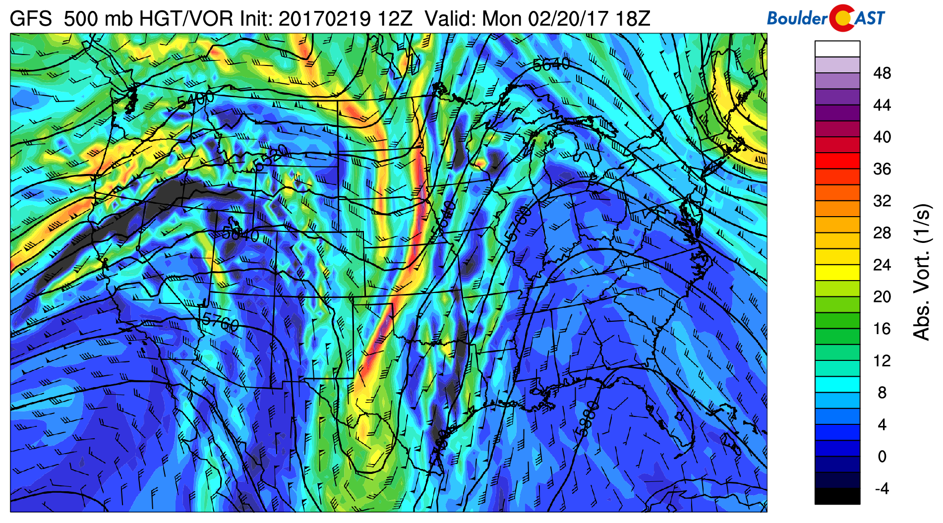
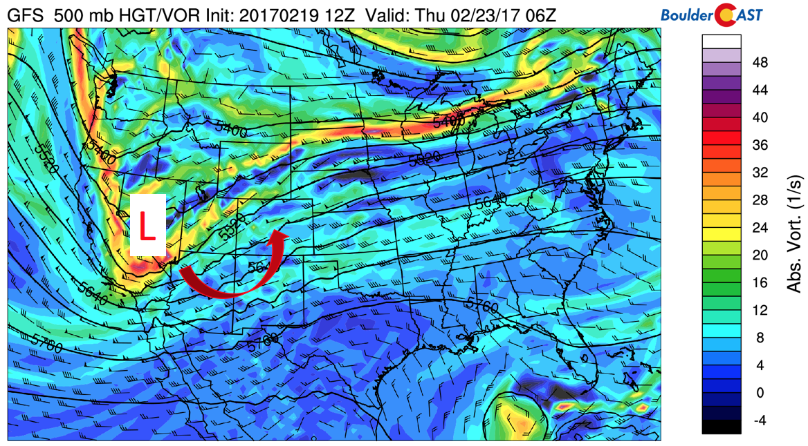
GFS 500 mb absolute vorticity and heights for today
Windy and warm Monday night through Wednesday afternoon…
A series of waves from the upper-level jet stream will advance overhead from the Pacific Monday night into Tuesday, and Tuesday night into Wednesday, bringing with it strong downslope wind potential. Below shows the upper-level jet stream pattern for early Tuesday and Wednesday. On Tuesday, the jet stream is oriented more southwest to northeast, primarily located across northwestern Colorado and Wyoming.
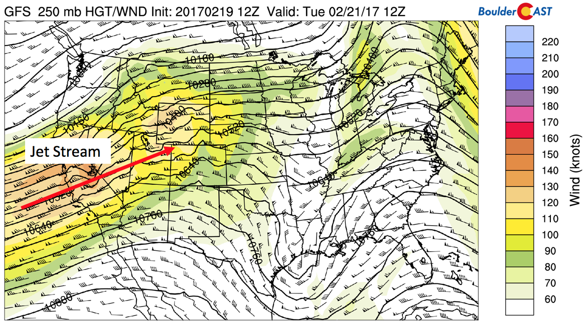
GFS 250 mb jet stream pattern for early Tuesday
On Wednesday, the jet shifts southward and is oriented more west to east and has two branches, each of which encompasses Colorado with wind speeds exceeding 120 mph in the upper-levels.
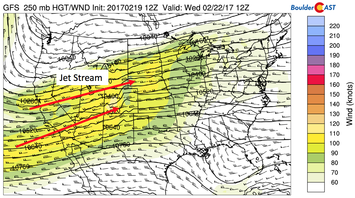
GFS 250 mb jet stream pattern for early Wednesday
Below shows the result of the jet stream and its effects for the Plains of Colorado, along with a trend in surface temperature as we go through the week from the NAM and GFS forecast models. Focus on the plot on the left first and the areas highlighted in the red circle and square. These time periods denote Monday night into Tuesday and Tuesday night into Wednesday. They show westerly downslope wind potential both time periods. The NAM model is showing winds of 30 mph Monday night into Tuesday morning, though is hinting that some of this may not mix down to the surface. A more substantial wind storm is possible Tuesday night into Wednesday morning, with winds exceeding 60 mph aloft, which are forecasted to reach the surface. If this forecast holds true, we could see wind gusts above 60 mph late Tuesday night and early Wednesday. We’ll keep an eye on this as we get closer. As a result of these downslope winds, surface temperatures Tuesday and Wednesday will continue to be quite warm, possibly in record territory Tuesday in the middle 70’s and upper 60’s on Wednesday. This is evident in the GFS surface temperature trend for the week, showing highs well above average through Wednesday. A downward trend towards Thursday and Friday shows cooler weather is on the way, though!
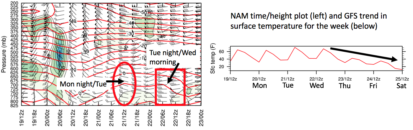
NAM time-height plot of relative humidity, wind speed vectors (left) and GFS model surface temperature trend through the week (right)
Another view of this downslope flow is shown below via a map from the NAM forecast model for the same time periods discussed above during the potential two wind events. The atmospheric force driving this is a pressure gradient of high pressure across western Colorado and low pressure in eastern Colorado. The atmosphere flows from high to low pressure, resulting in westerly winds that rise up the High Country to our west and sink on the eastern side into the Foothills and Plains.
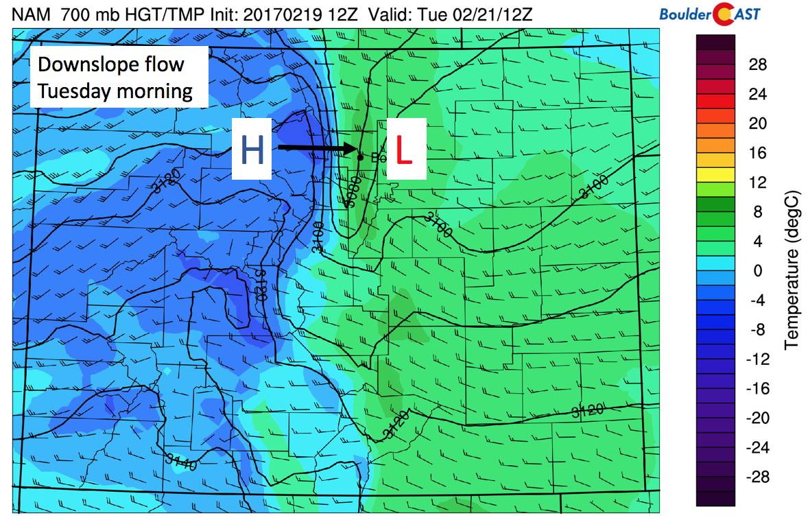
NAM near-surface height, wind, and temperature (degC) for Tuesday morning
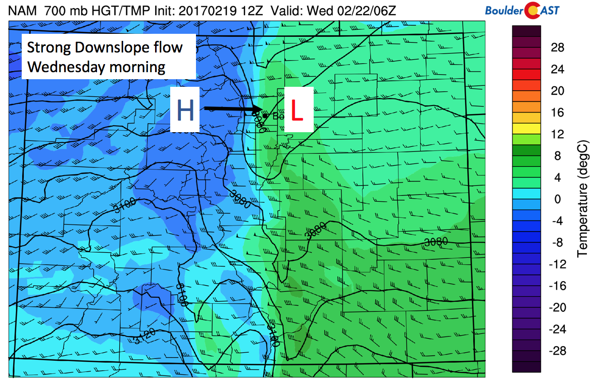
NAM near-surface height, wind, and temperature (degC) for Tuesday night
Thursday and Friday colder with mountain snow. Snow on the Plains??
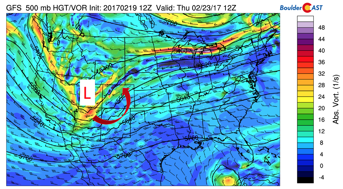
After a warm day Wednesday, a cold front will slide down late in the evening into Thursday, bringing with it colder air, cloud cover, and the chance of snow late Thursday into Friday. Below shows the mid-level pattern late Wednesday night. An area of low pressure is situated across western Nevada and eastern California, with upslope flow working its way into our state.
GFS 500 mb absolute vorticity and height for Wednesday night
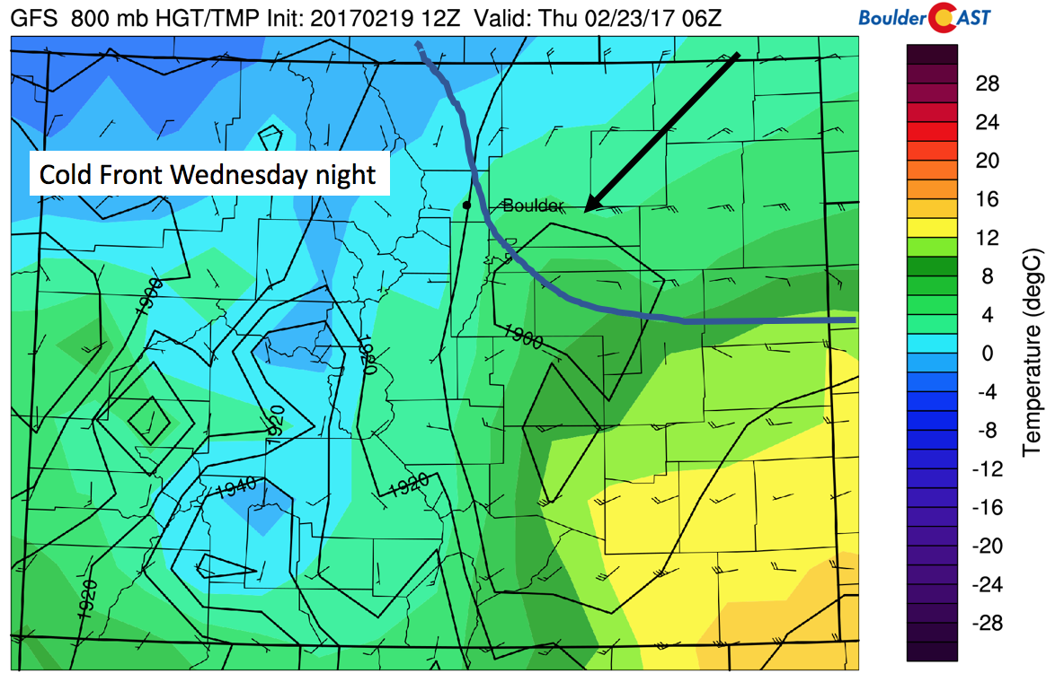
The approach of the low pressure will lower height fields and allow the surface cold front to pass through us Wednesday night, setting up for highs on Thursday some 25 degrees colder than Tuesday and Wednesday in the lower 40’s. The map below shows the front from the GFS model (blue line and arrow denoting the movement) and northeasterly upslope flow. This initial surge will not be very strong, but a second and more potent surge comes Thursday night.
GFS depiction of the surface cold front Wednesday night
On Thursday afternoon the low pressure system that was in Nevada moves eastward and with it comes increasing moisture for both the High Country and Plains. Although we are far out, the models are in fairly good agreement that this system will push through…although the position and track remains highly uncertain. There is little doubt the mountains will once again see snow after a week of relatively dry conditions! It’s possible 4-10″ of snow could fall in the High Country Wednesday night into Friday (see snowfall map below). Skiers have something great to look forward to…fresh powder! As for the Plains, the forecast is less certain and only general specifics are given below.
GFS 500 mb absolute vorticity and height field for Thursday
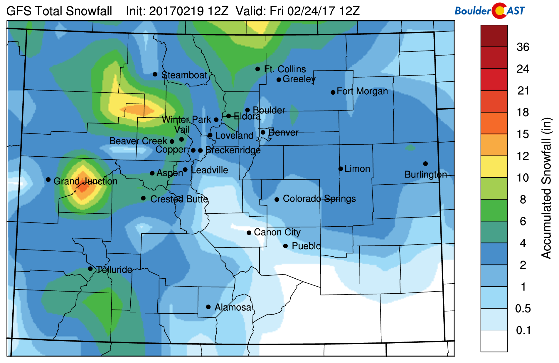
GFS total snowfall by Friday
With the low pressure system overhead Thursday, below shows the associated surface cold front and potential upslope flow. The red line denotes the cold front. As is evident, counter-clockwise rotation is forecasted with the area of low pressure over far southeastern Colorado. This would favor rain to snow across the Plains Thursday night into Friday with maybe 1-4″ for the Denver Metro. However, we are too far out to make any “true” predictions. Forecast models are likely to diverge between now and Thursday. If conditions warrant, we will update you later in the week if a snow storm comes to fruition. In the mean time, we continue to turn colder Friday with highs likely in the middle 30’s, a far cry from where we were on Tuesday. So enjoy the warm spring weather while you can!
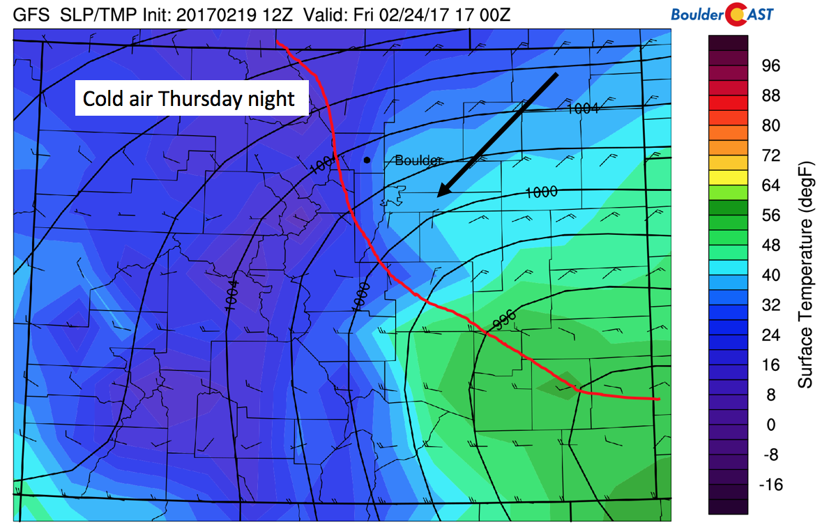
GFS secondary surge of cold air and upslope flow Thursday night into Friday
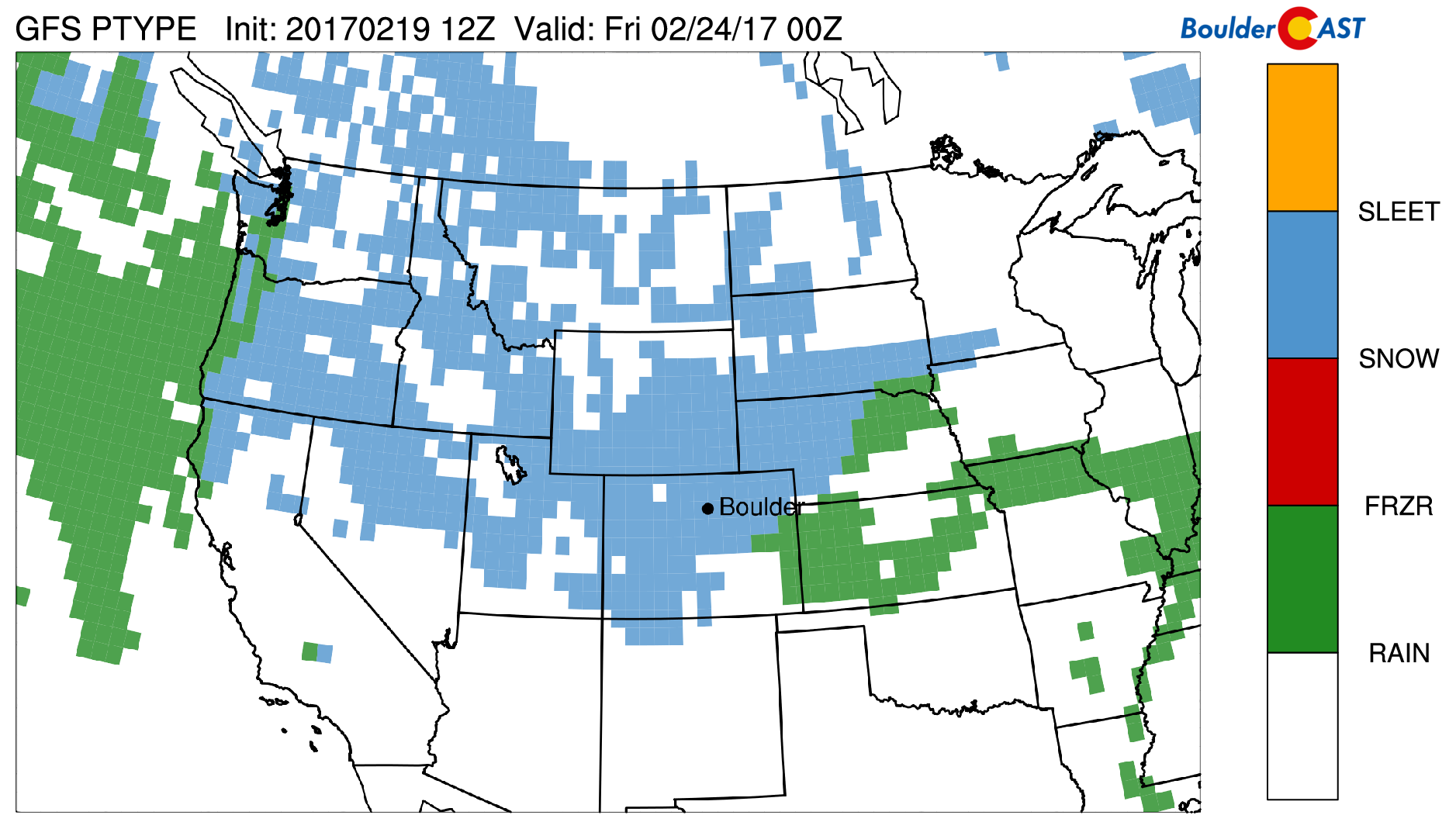
GFS precipitation type forecast for Thursday night across the western United States. GFS predicts widespread snowfall across Colorado
Extended outlook potentially active to end February
The extended outlook shows a trend toward a potentially more active pattern after relatively calm weather for most of February. The animation below shows the GFS ensemble mean forecast from yesterday until the first of March. Red colors denote above average heights (high pressure) and blue colors denote below average heights (low pressure). As we go into this upcoming weekend, a series of troughs look to effect our state, likely resulting in more snow for the Mountains. Depending on the track of these systems, some could affect the Plains. However, we are not completely sold on this pattern shift as sometimes these ridges of high pressure are tough to break. But all signs currently point to a colder trend…stay tuned!
GEFS ensemble mean model forecast from Sunday into March 1st
Forecast Specifics:
Monday: Mostly sunny and warm with high temperatures in the lower 60’s on the Plains and low 50’s in the Foothills. Gusty winds possible late Monday night exceeding 35 mph.
Tuesday: Gusty winds possible in the early morning 35+ mph, then decreasing in the afternoon to 10 to 20 mph. Highs in the middle 70’s for the Plains and lower 60’s in the Foothills under partly cloudy skies. Strong gusty winds possible again late Tuesday night, potentially exceeding 55 mph.
Wednesday: Strong winds possible early Wednesday with gusts potentially exceeding 55 mph. Partly cloudy skies in the afternoon with highs in the upper 60’s on the Plains and lower 60’s in the Foothills.
Thursday: Partly sunny skies then increasing clouds by late morning. Colder with highs in the lower 40’s on the Plains and middle 30’s in the Foothills. Potential exists for rain changing to snow during the day and overnight into Friday, but too far out to make any accurate predictions.
Friday: Mostly cloudy with light snow possible early, then partly sunny skies in the afternoon with temperatures colder in the middle 30’s on the Plains and upper 20’s in the Foothills.
High Country: Light snow from Sunday may linger into today, but should taper off by early evening. A break then takes over Tuesday. On Wednesday night, clouds will stream in with an increase in moisture and snowfall to start as early as Wednesday night across southwestern Colorado and encompass much of the High Country on Thursday. Another wave of snowfall is possible Friday night through Sunday, but timing of these events is rather tough this far out. Amounts by Friday could lead to an accumulation of 6-12″. Skiers will be happy!
Mon
Tue
Wed
Thu
Fri


Temperature
60
74
68
43
36


Precip Chc (Plains)
0%
0%
0%
30%
20%


