We’re tracking two wintry systems for the week ahead. The first one will mainly impact the higher elevations on Monday. The second one is scheduled to arrive on Thursday with perhaps better chances for snow across the Denver Metro area. Read on as we detail for the forecast for the next five days.
Weekend snow recap
Light snow and wintry mix fell Friday night, transitioning to all snow by Saturday morning. Snowfall was generally light, but there was some enhancement from the overhead jet stream across southern Denver during the day Saturday.
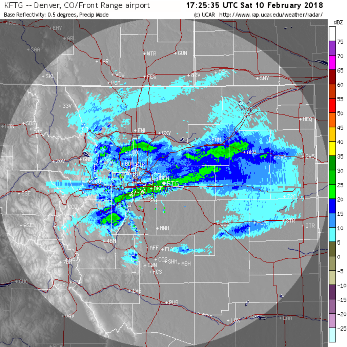
Radar image from 10:00 AM on Saturday February 10, 2018 showing banded snowfall across parts of the Metro area.
Shown below is our original forecast map created Friday morning for the northern Metro area. The observed storm totals per location are contained in boxes. Green ones indicate that the observed snowfall was within one inch of the given forecast range, while red was outside the scope of our forecast.
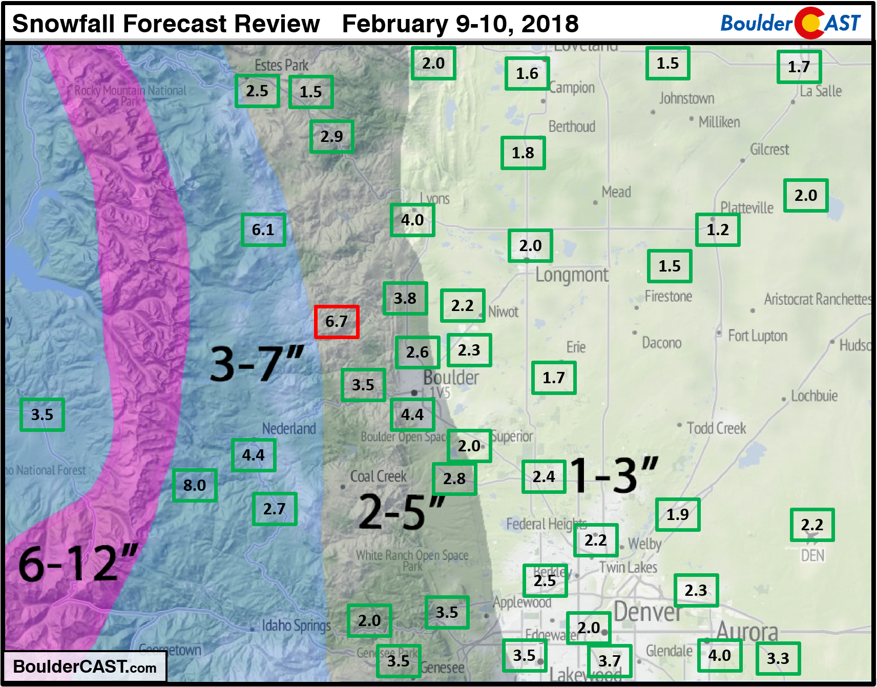
Our forecast turned out quite well again across the region. Officially, Boulder received 5.7″, while Denver reported 2.2″. The only “bust” we could find was in Jamestown in the Foothills west of Boulder which recorded 6.7″, just beyond our 2-5″ range. Otherwise, all green across the board.
This brings the 2017-2018 winter snow totals to:
- Boulder – 37.6″
- Denver – 15.4″
This was our tenth “snowstorm” of the season. Head over to our 2017-18 Winter Summary page to find an overview of every snowstorm so far this winter.
Monday’s system spares most of eastern Colorado
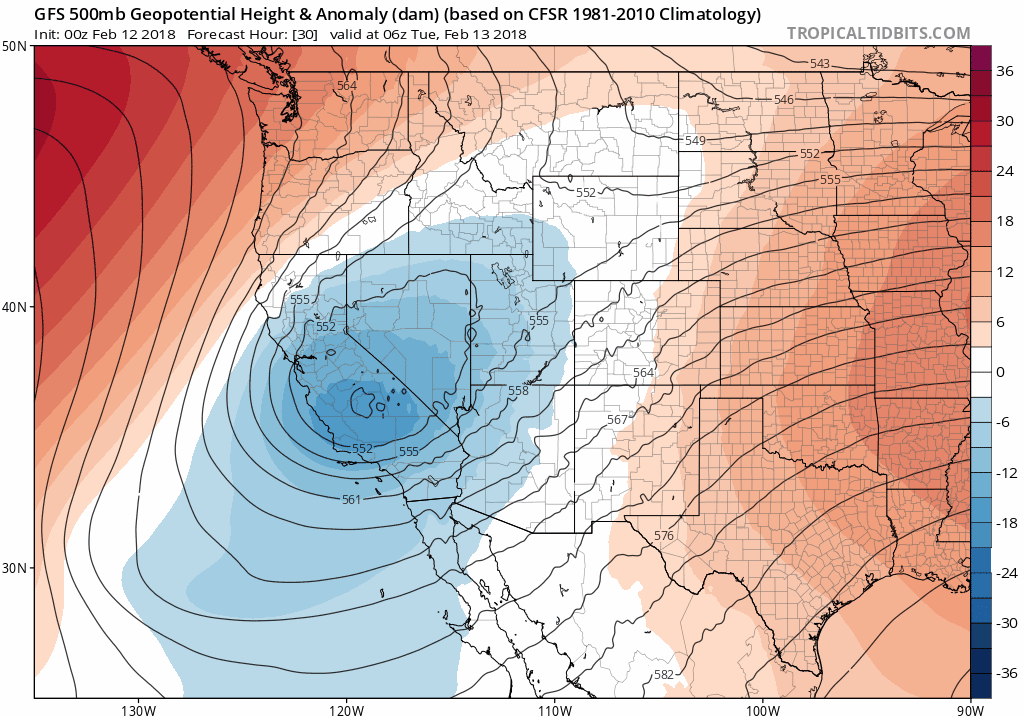
The 500 mb height anomaly animation below shows the two weather systems of interest this week.
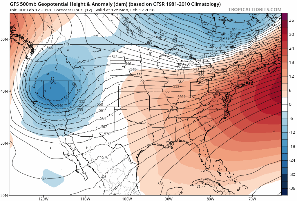
GFS model 500 mb height anomaly animation through Friday. Two troughs are staged to impact Colorado.
The first is already situated across northern Nevada this morning. The storm is actually forecast to cut-off and retrograde through the first half of the week. This just means that the low pressure will move in opposition to the general flow and track westward.
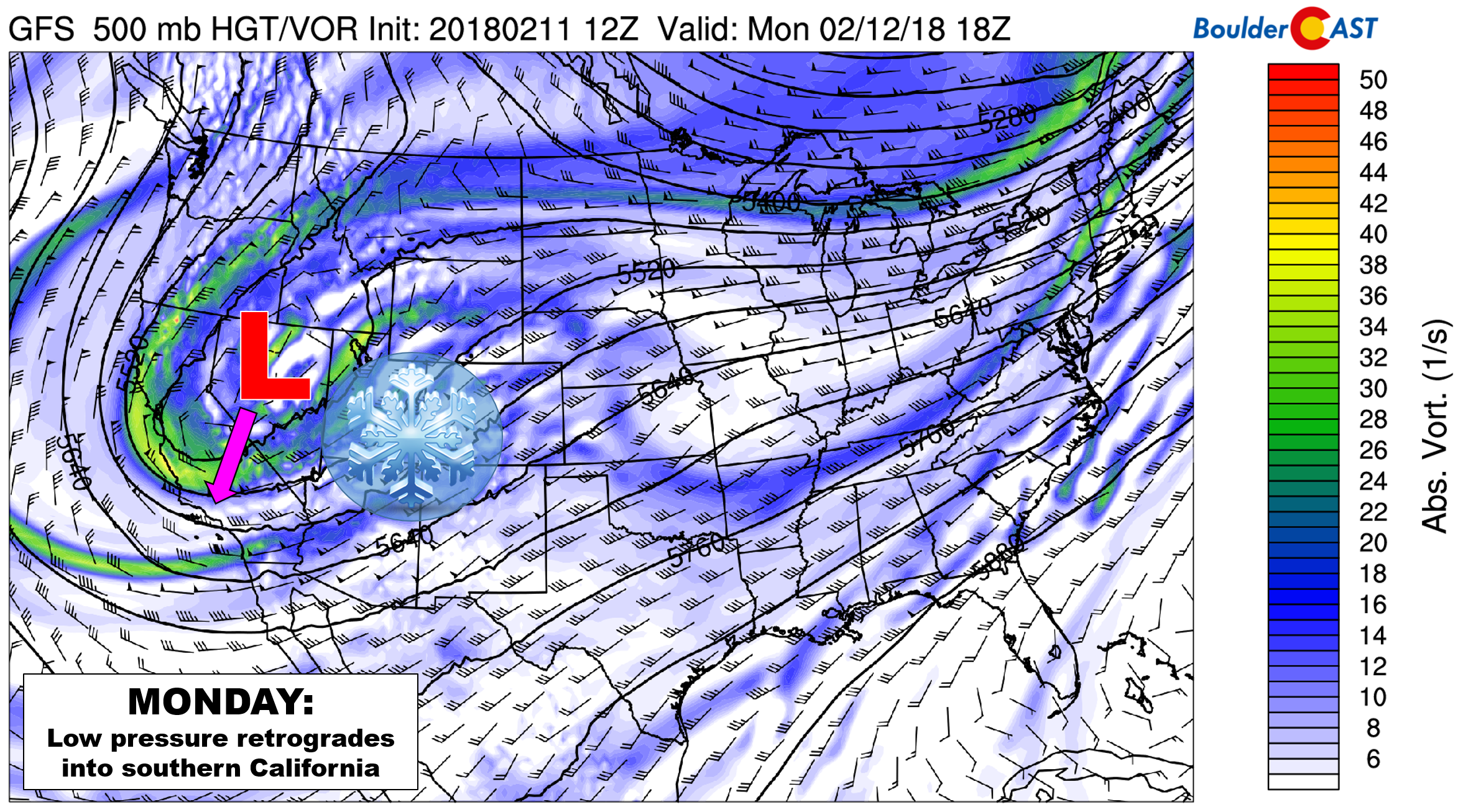
GFS 500 mb vorticity map for Monday. Low pressure across Nevada will move into California, with widespread snowfall expected in Utah and southwest Colorado.
Moist southwest flow is streaming into southern Utah and western Colorado this morning. The system is mostly too far away to impact the Front Range. Large-scale forcing here will be minimal. As the storm moves westward, its impacts will lessen further heading into midweek. For this reason, western Colorado is where we expect the heaviest snowfall to occur. Ski resorts such as Telluride, Purgatory, and Wolf Creek will see their biggest dump in many week’s time Monday into Tuesday (8 to 15 inches).
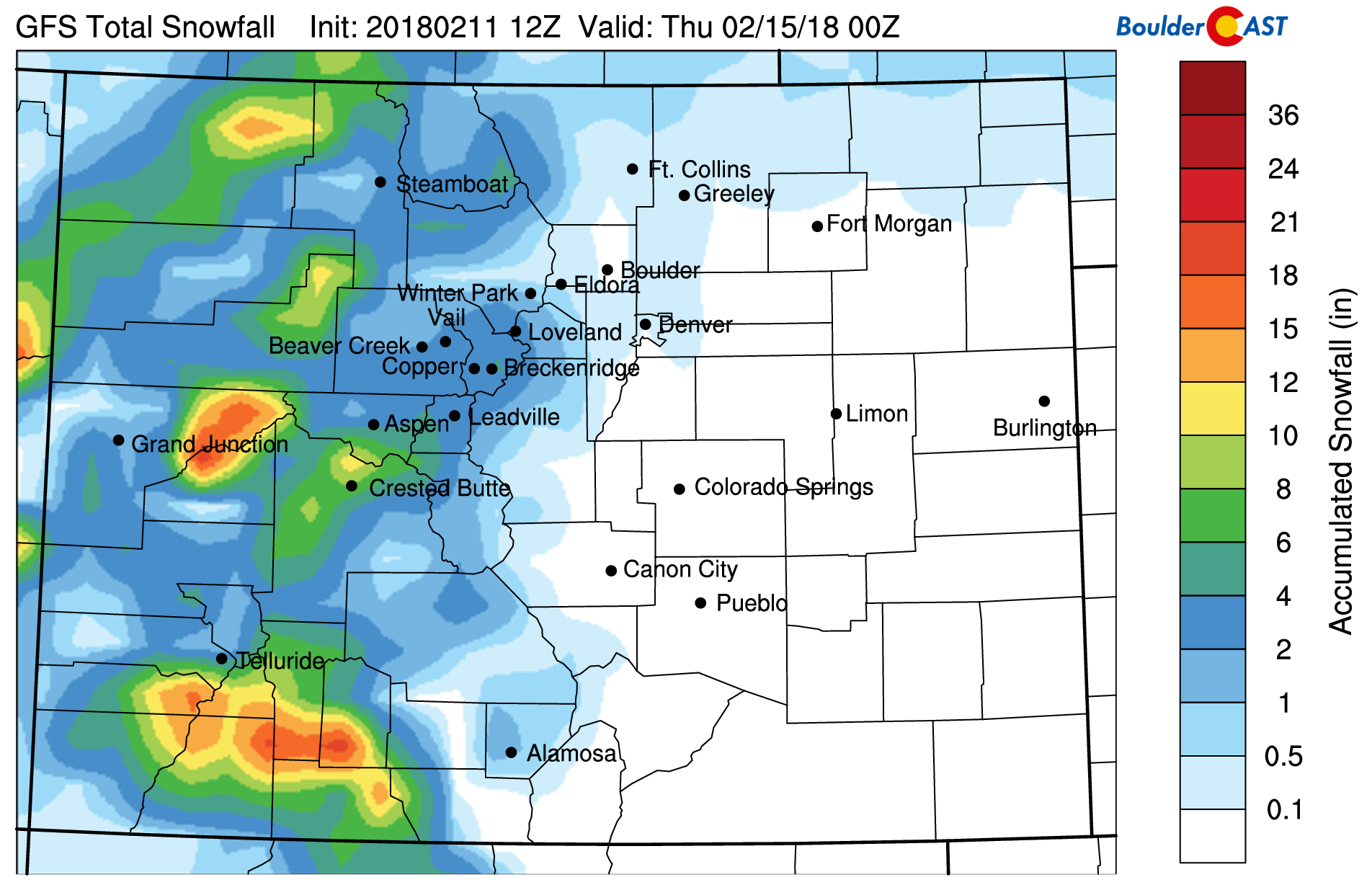
GFS model-derived snowfall forecast for Monday and Tuesday. Most snow will remain across western Colorado.
Across the Denver Metro area, the main impact from this system will be the cold air on Monday. Upslope moved in overnight and temperatures have fallen into the teens and lower 20’s. Some areas are reporting freezing fog early this morning, but it appears to be fairly patchy. With the mostly cloudy skies and on-and-off light snow showers through the day, we won’t be warming up much….25 degrees will be about it.
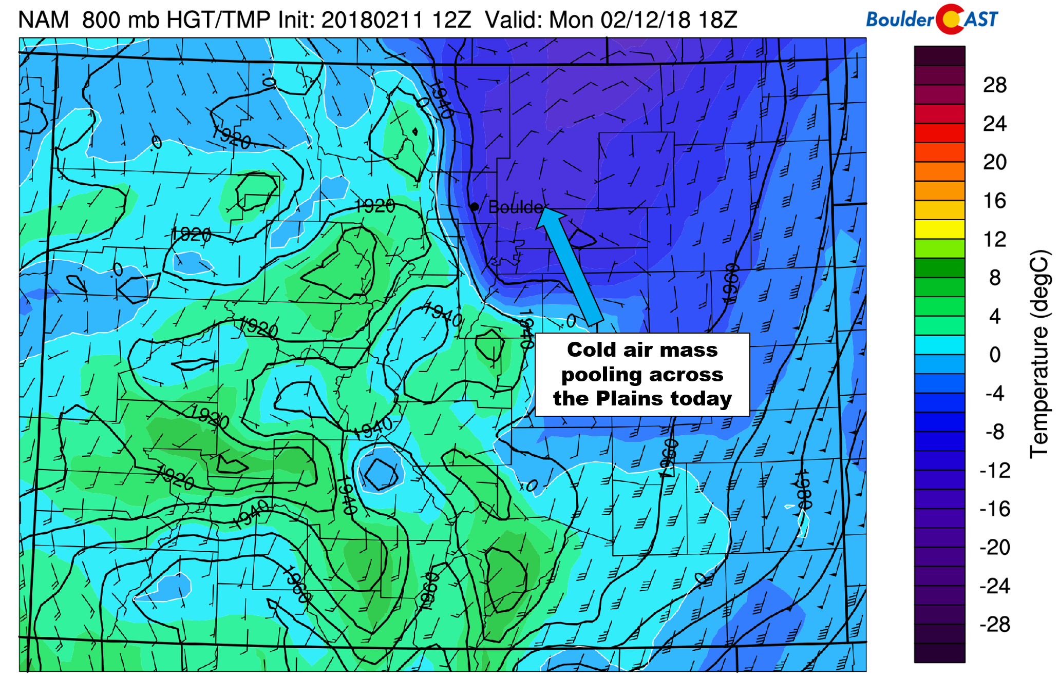
NAM 800 mb wind and temperature forecast for midday Monday. Cold air and upslope is entrenched across northeast Colorado.
High-resolution models are showing potential for isolated banded snowfall Monday evening thanks to a developing jet streak across Colorado (see below). They should be quite isolated in nature and have snowfall rates generally less then 3/4″ per hour. The HRRR model shows a few bands forming west of a line from Broomfield to Fort Collins after between 4:00 PM and 10:00 PM this evening. Areas impacted by these bands could see brief moderate snowfall and a quick inch of snow accumulation.
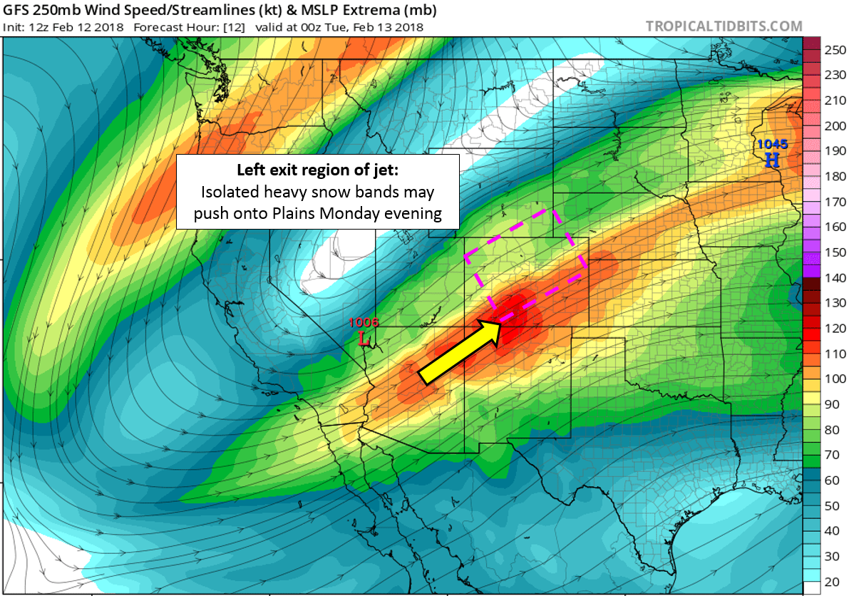
GFS 250 mb wind forecast for Monday evening. We’ll briefly be in the left-exit region of the jet, allowing for a few isolated snow bands to roll of the higher terrain Monday evening.
Warming up Tuesday and Wednesday
The high pressure center responsible for the upslope flow and cold air influx on Monday will shift eastward into the Northeast. As a result, Tuesday and Wednesday will see a warming trend take hold across eastern Colorado. Models are aggressive with the warm-up right now, pushing temperatures for the Plains into the 50’s Tuesday and 60’s on Wednesday. This all seems reasonable given the mid-level warming and mostly sunny skies. We also look for a windy day across the Metro area on Wednesday.
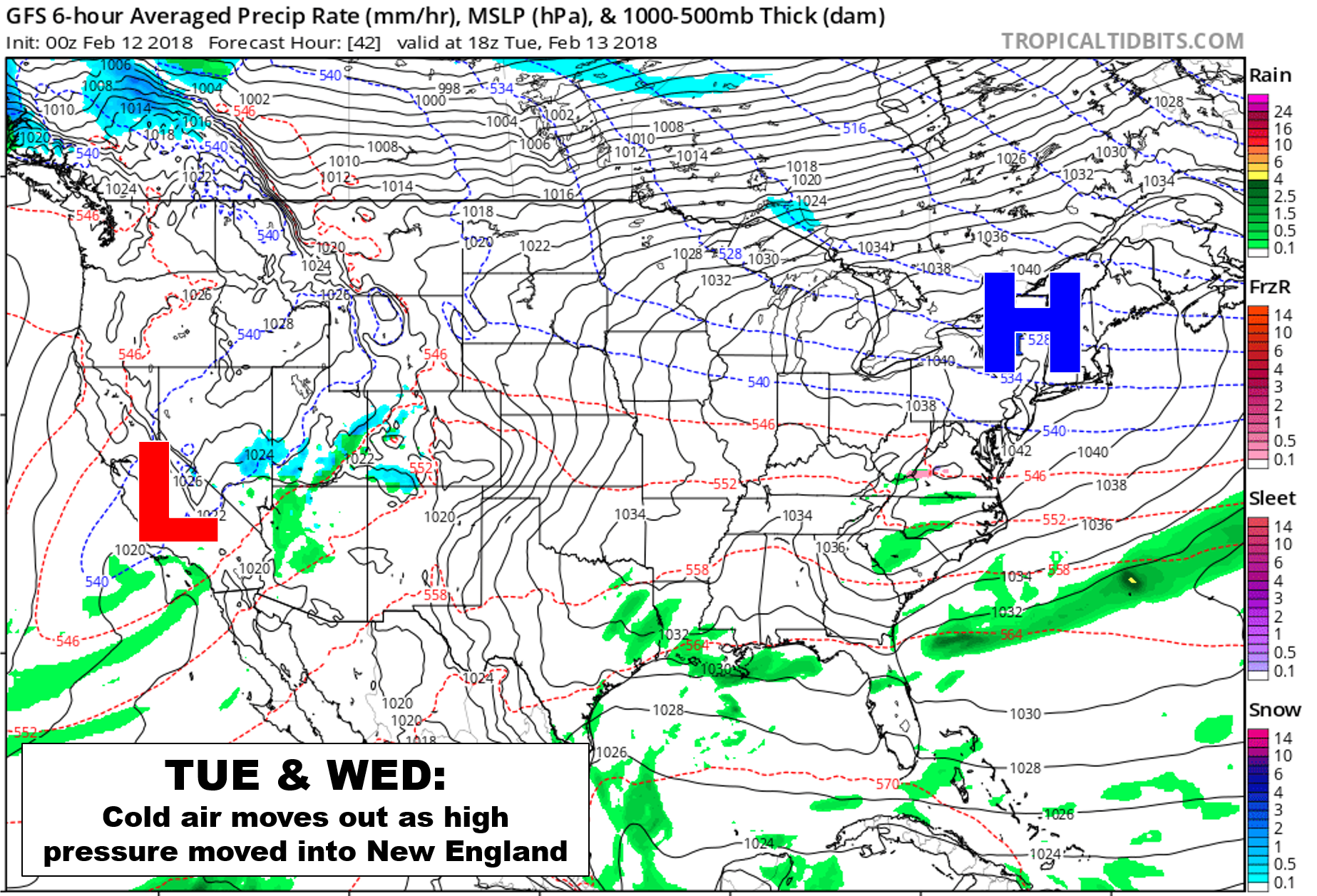
GFS precipitation and 1000-500mb thickness map for Tuesday afternoon.
Second system to impact Colorado Thursday
The cut-off low across southern California will not move much at all through mid-week. However, a second trough is projected to scurry across the northern Rockies on Thursday, potentially absorbing the California low in the process. You can see “Big Fish” eat “Little Fish” in the animation below:
GFS model 500 mb height anomaly animation through Friday. Watch as the trough swallows the cut-off low.
The GFS ensembles show Monday’s chance of a few light flurries, and the potentially more substantial Thursday afternoon/evening storm.
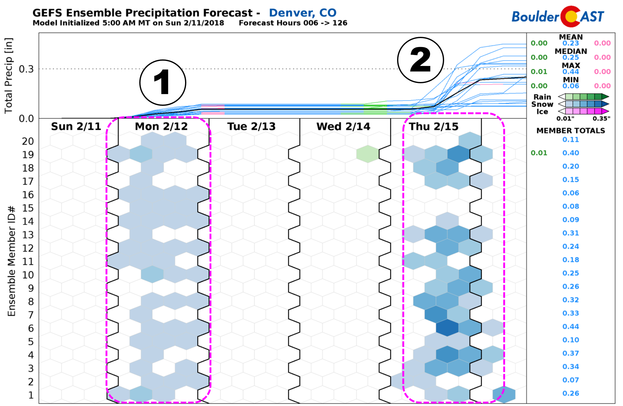
There is a lot of uncertainty surrounding the evolution of the Thursday storm across eastern Colorado. The interaction of the cut-off low and the main trough is a tough one to predict, one we definitely won’t trust four days out. Nonetheless, it appears a cold front will move into the region from the north on Thursday with temperatures falling from the 40’s into the 20’s. Most of us will see some snow with light accumulations possible. We can’t fully rule out some freezing drizzle either. Our snowfall probability charts show small chances for Boulder and Denver to exceed 2″ of snow this week. However, stay tuned over the next few days for updates.

By Friday, drier northwest flow will likely be in place across Colorado. This should usher in sunshine and milder temperatures in the 40’s. The upcoming weekend looks fairly good as well. Sunny skies and 50’s are the current model trends.
Have a great week! May the Arctic cold fronts and tiny winter storms transition to bigger spring snows soon…
Forecast Specifics:
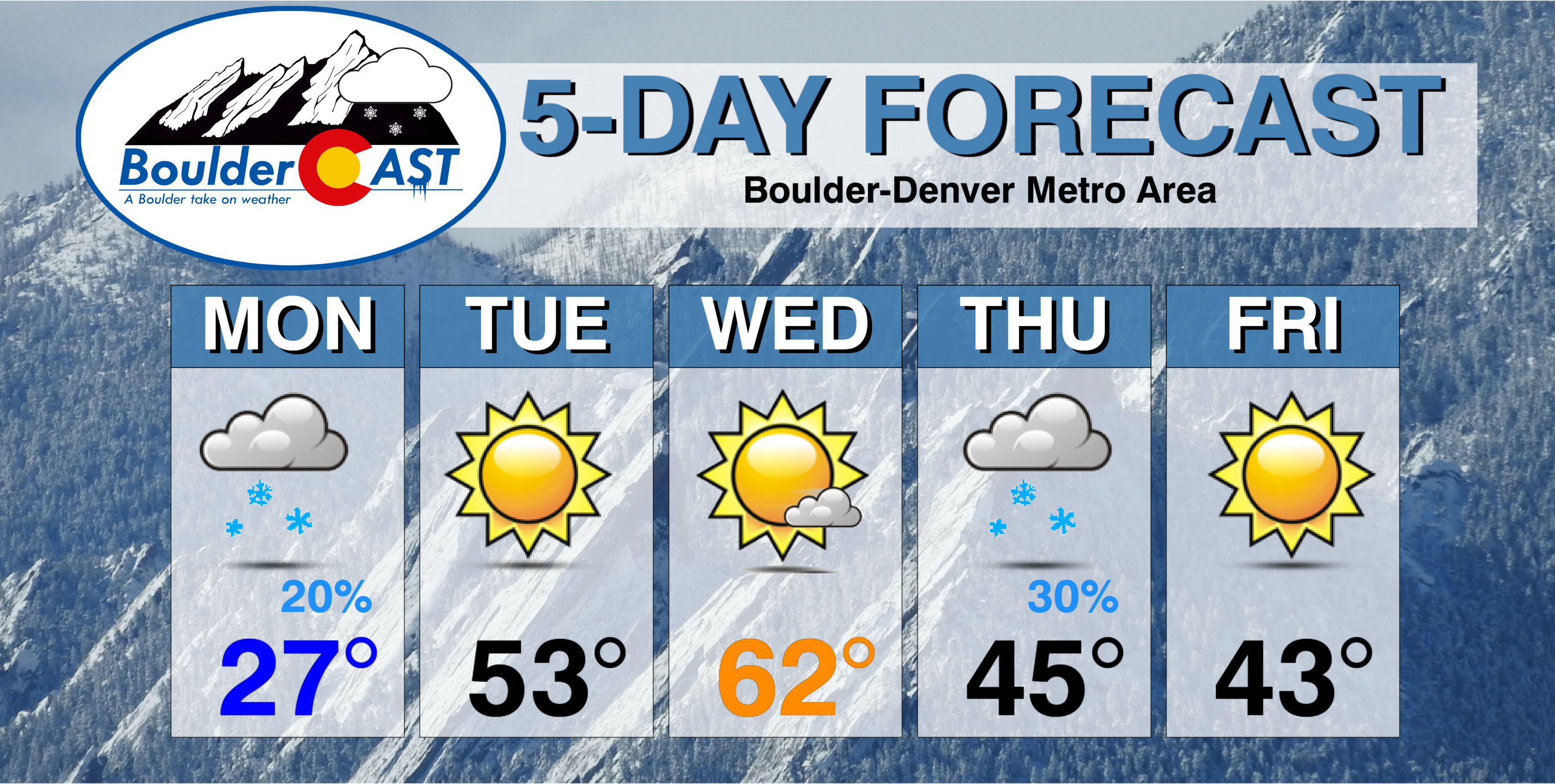
Monday: Patchy freezing fog in the morning. Then mostly cloudy and cold with light snow showers or flurries through the day. Some sun is possible in the afternoon, along with a few isolated moderate snow bands from the jet this evening. At most, a few locations could see up to 1″ of accumulation from these bands, however most areas will see a trace or less. Highs will be in the 20’s across the Plains and in the 30’s for the Foothills.
Tuesday: Sunny and milder. Highs in the lower 50’s for the Plains with upper 30’s in the Foothills.
Wednesday: Mostly sunny, pleasantly warm and windy. Gusts in and near the Foothills could exceed 35 mph. Highs in the low 60’s across the Plains, and low 50’s in the Foothills.
Thursday: Overcast and much colder with a front moving through during the day. Snow showers or a wintry mix will be possible through the afternoon and evening. At this time, accumulations are expected to be light. High temperatures in the 30’s or 40’s across the Plains, with 30’s in the Foothills.
Friday: Sunny and seasonal with temperatures in the low to middle 40’s across the Plains. Expect highs near freezing in the Foothills.
High Country: Snowfall will be widespread across southwest Colorado Monday with 5-15″ possible (dependent on elevation and slope orientation with southwest being favored). For the northern part of the state, expect lighter and more scattered snow showers Monday into early Tuesday with 2-4″ of accumulation. Snow then returns Wednesday night into Thursday evening with several more inches of accumulation likely. The week ends with sunny and calm conditions statewide on Friday into the first half of the weekend. Find the latest forecast for all your favorite Colorado ski resorts on our PowderCAST page.
DISCLAIMER: This weekly outlook forecast was created Monday morning and covers the entire upcoming week. Accuracy will decrease as the week progresses as this post is NOT updated. To receive daily updated forecasts, subscribe to BoulderCAST Premium.

.
Share!


