We hope you had a safe and festive holiday weekend! Despite the very cold start to the week, warmer weather is on the way! Read on for our outlook covering the upcoming week, including when we expect our next chance of snow.
One more day of Arctic air
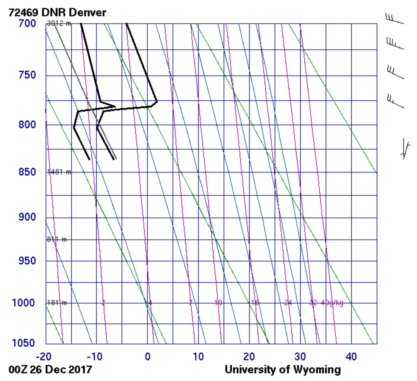
The high in Boulder was 24 degrees yesterday, our coldest Christmas since 1990! Favorable low-level winds flowing clockwise around a 1050-millibar dome of high pressure in Montana have kept a shallow Arctic airmass banked up against the Foothills. The diagram below shows temperature data (rightmost thick black line) collected from the balloon launch in Denver Monday evening around 5PM. Notice the very strong inversion at 780 mb, that is where temperature sharply rises with altitude. This is the top of the Arctic airmass, equating roughly to an altitude of 7,000 feet. The temperature was actually above freezing up there, while it was only 14 degrees in Denver!
The current temperature map as of 8:00 AM Tuesday is shown below. Can you pick out the edge of the Arctic air west of Boulder? Yep, it’s in the single digits across the Plains this morning, but just a few miles west (and 1,500 feet up), temperatures are above freezing!
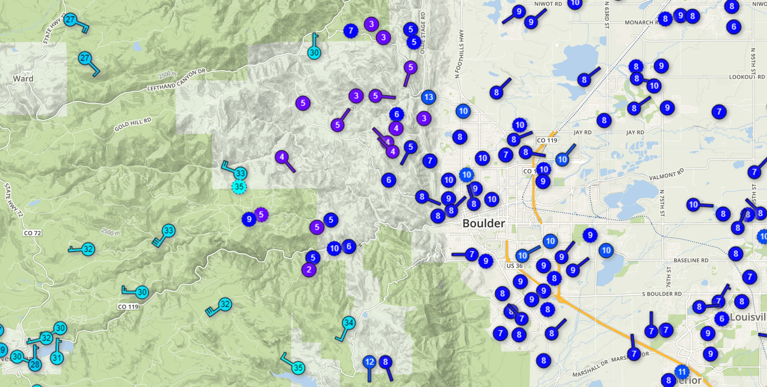
Temperatures Tuesday morning in Boulder County. The shallow airmass turns much warmer near 7,000 feet elevations.
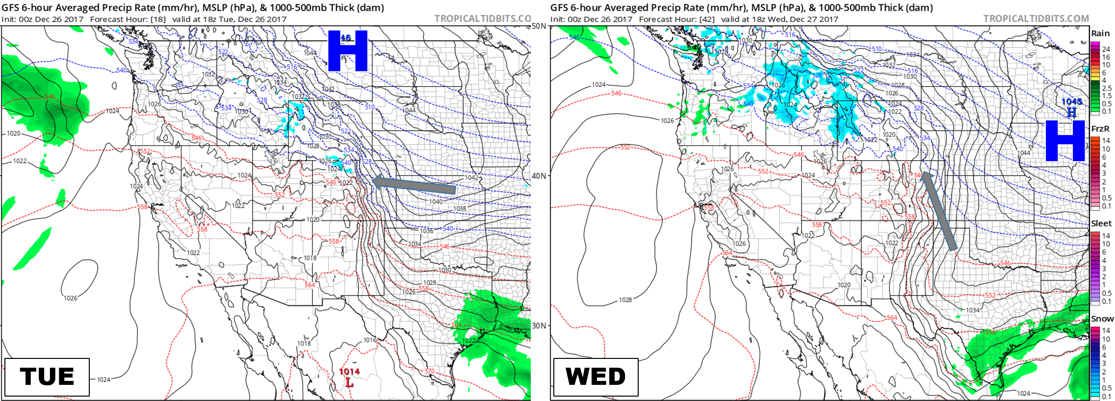
The good news is that milder air is on the way! The bad news is we’ll have to endure one more day of FRIGID temperatures. The two maps below show that the Arctic high in Montana will trudge eastward into Iowa by Wednesday afternoon. This will change the low-level winds to southerly for the Front Range, allowing downslope northwesterly flow to mix with and eventually erode the shallow cold air. Until that happens however, we’ll be shivering today with temperatures in the teens across the Plains.
Furthermore, this shallow upslope and a dabble of moisture will combine this morning to produce low clouds and snow flurries across the region. A fluffy dusting of accumulation is possible, with overcast skies remaining through the day. Models are showing the potential for some sunshine this afternoon, but I wouldn’t count on it given the heavily stratified atmosphere.
Northwest flow….warms us up?
Latest model guidance shows the cold air eroding out sometime Wednesday morning. Our savoir is northwest flow! It’s not very often we look to northwesterly winds to warm us up. However, pretty much anything would be warmer than what central Canada has thrown our way the last few days!
The 500 mb map below shows the atmospheric set-up for Thursday. It will be very similar Wednesday and Friday as well. Most notably, northwest flow across Colorado, ridging in California, and troughing into the Great Lakes.
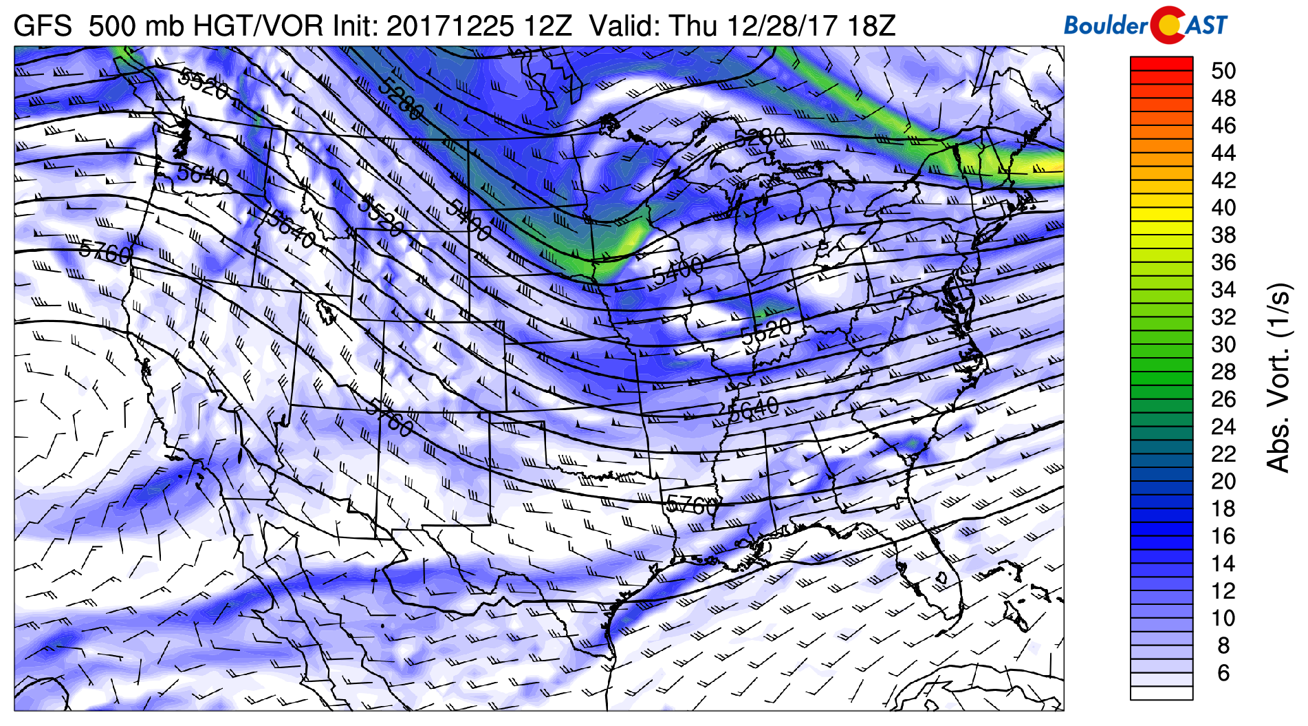
With large scale subsidence from the ridge to our west, the rest of the week will be calm across Colorado in general. We’ll be fairly sunny with temperatures much warmer than they have been, probably in the 40’s and 50’s through Friday with no chance of precipitation. A pair of passing disturbances through Wyoming will produce light snow in the Mountains on Wednesday and then again on Friday. Nothing to note at this time for the Plains.
We do caution that some models are showing the potential for the edge of the cold air to work back into Denver on Thursday (a cold front associated with the trough in South Dakota above). It looks a little iffy right now, and even if it does happen, it wouldn’t change the forecast much (outside of cooling us down about 10 to 15 degrees). The sun would still be shining regardless.
New Year’s Eve Snow?
We’re watching for a more substantial push of cold air again this upcoming weekend. Four to five days out, model spread is quite high, but Saturday evening or early Sunday may offer our next potential for a few snowflakes. It’s yet another quick-mover riding on the northwest jet….it will probably be more bark (cold) than bite (snow).
As always, we’ll keep you updated on this one. Have a great week!
Forecast Specifics:
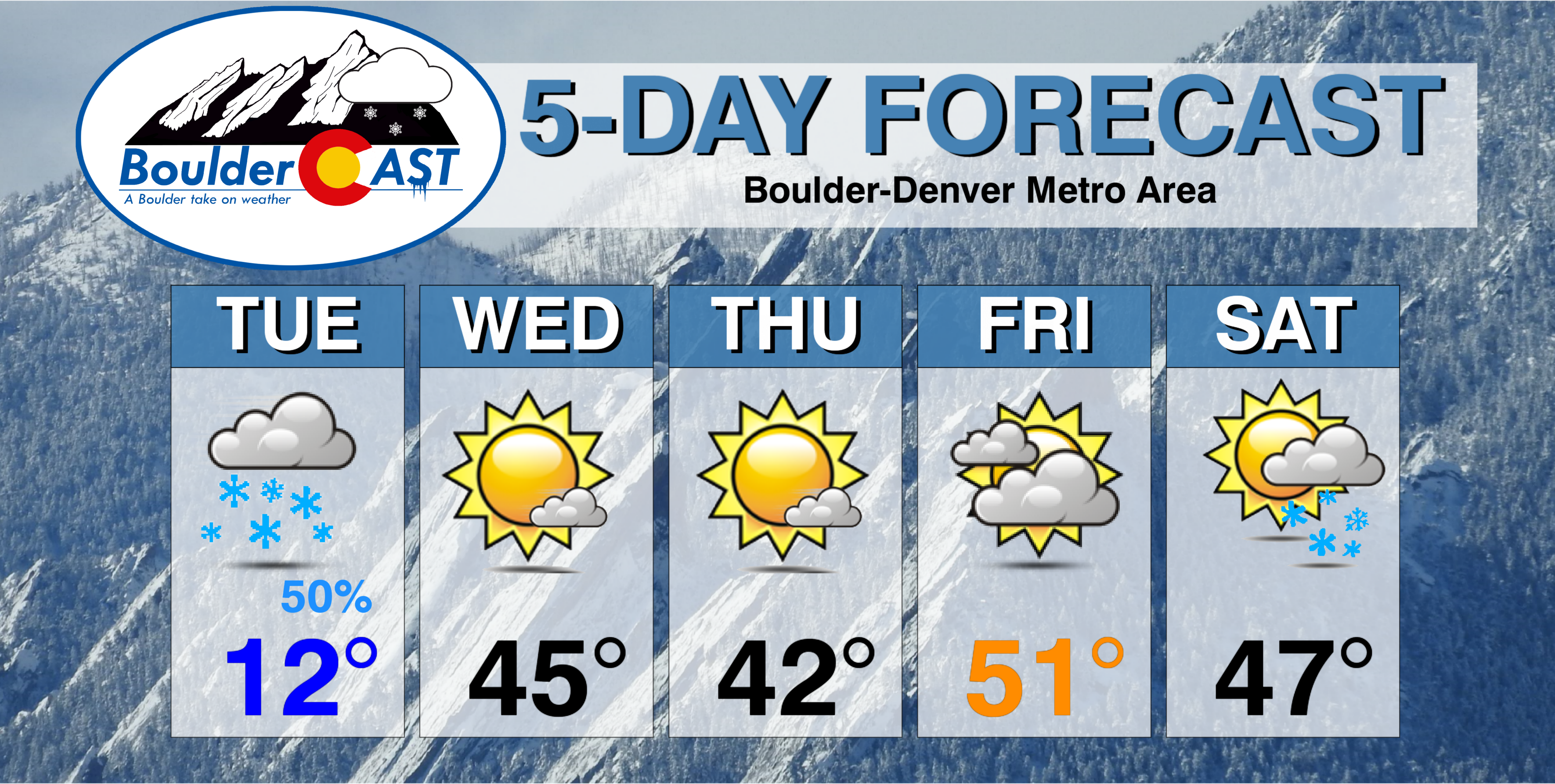
Tuesday: Overcast and frigidly cold, with light snow and flurries across the Plains. Some areas could see freezing fog as well early Tuesday morning. Highs in the middle teens for the Plains with middle 30’s in the Foothills.
Wednesday: Lots of sunshine and much warmer. Highs in the upper 40’s for the Plains and in the upper 30’s in the Foothills.
Thursday: Mostly sunny, mild, and breezy. Highs in the low to mid 40’s across the Plains, low 30’s in the Foothills.
Friday: Partly to mostly cloudy and warmer ahead of the weekend system. Expect highs in the 50’s for the Plains, and in the 40’s for the Foothills.
Saturday: Highs somewhere in the 40’s or 50’s (depending on the timing of a cold front), with falling temperatures and light snow possible late in the day.
High Country: After a hefty dumping of powder the last few days, light snow will continue Tuesday and Wednesday for the Mountains north of Interstate 70 with northwest exposure. Dry and slightly warmer weather will prevail Thursday, then the chance of light snow returns to the same northern Mountains on Friday. Accumulation will be a few inches or less through the week. Find the latest forecast for all your favorite Colorado ski resorts on our PowderCAST page.
DISCLAIMER: This weekly outlook forecast is was created Tuesday morning and covers the entire upcoming work-week. Accuracy will decrease as the week progresses as this post is NOT updated. To receive daily updated forecasts, subscribe to BoulderCAST Premium.

.
Share!
.


