After polar air and snow this past weekend, a very nice warm up is in store for the first few days of the week. Overall, expect a rather benign week but the High Country should see more snowfall. In the extended, we’re watching a potential snow storm Christmas Eve/Christmas Day. We’ll discuss that and the week ahead. Read on to find out more.
Thawing out…
Below shows the upper-level wind and height pattern for today. Colorado is currently between both the southern jet stream and the Arctic jet stream (now back up in Canada). As we saw on Sunday, temperatures warmed up into the low to middle 20’s on the Plains. Today, downslope flow will ensue and result in warm air continuing to spread in with temperatures some 20 degrees warmer in the low 40’s. This will really melt a lot of the snow on the ground. It will be a great day for skiing with several ski resorts last week and weekend seeing over 2 feet of powder!
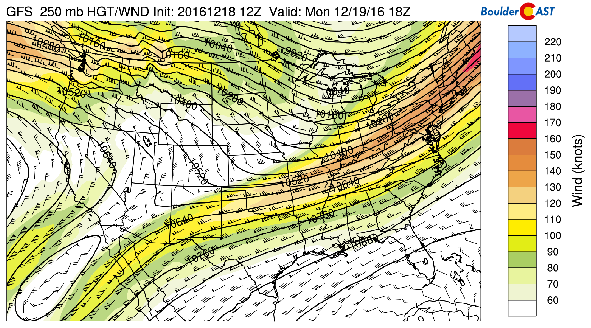
GFS 250 mb upper-level wind and height pattern today
On Tuesday, we will see our warmest day of the week. Below shows the GFS model mid-level atmospheric pattern on Tuesday. Of note is westerly flow continuing to entrench itself as the jet stream stays to our north. With that, warm air continues to spread eastward from the Divide. Expect low 50’s in most places. However, we would not be surprised if some spots see middle 50’s! What a change from where we were over this past weekend with overnight lows between 5 and 15 degrees below zero. Of note on the below map is the area circled in red….a low pressure system that will bring forth a cold front to the Front Range Wednesday.
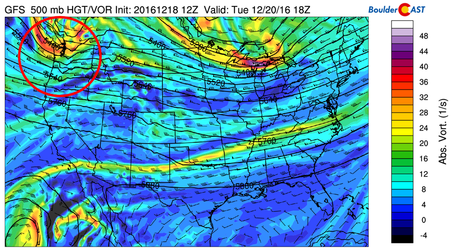
GFS mid-level atmospheric pattern for Tuesday
Another cold front arrives Wednesday
Below shows the low pressure system as of Wednesday afternoon. The system is now located over the Dakotas with northwesterly winds across the High Country.
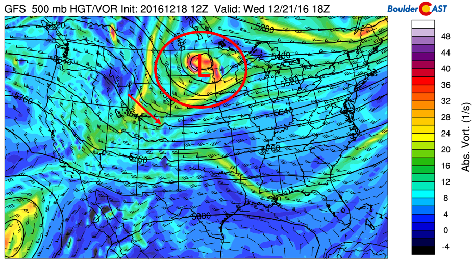
GFS mid-level atmospheric pattern for Wednesday
At the surface, this storm will bring with it mainly cold air. The low-level temperature and winds for Wednesday morning are shown below. We’re expecting the front to filter in during the mid to late morning hours on Wednesday. Notice the area circled in red (region of Plains and Foothills). Northerly flow and colder air is evident. This airmass will be some 12 degrees colder in the mid-levels of the atmosphere compared to Tuesday. As a result, we can expect highs near 40 degrees.
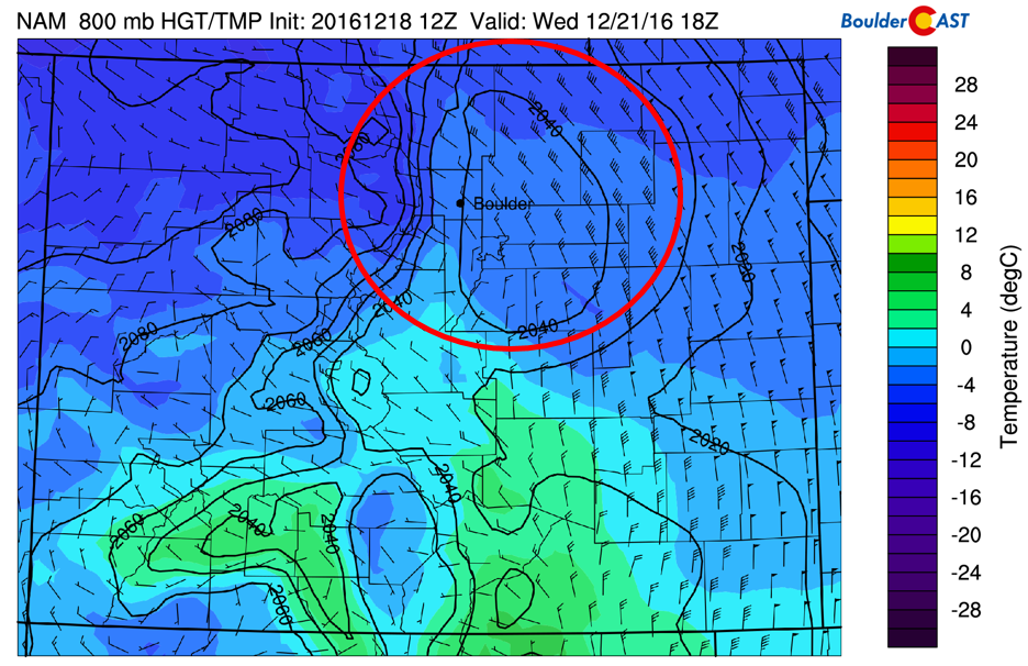
NAM low-level temperature and winds for Wednesday
The storm won’t really bring any snow chances to the Plains as all forcing for lift and moisture remains well northeast of us. The Plains will also be under downslope flow, which inhibits precipitation development for us. But the High Country will be happy as the northwest flow will bring additional snow. Expect northwestern Colorado to be favored, such as Steamboat, Winter Park, and Vail. Certainly not a big storm by any means. At best, we’d expect 1-3″ for the mountains.
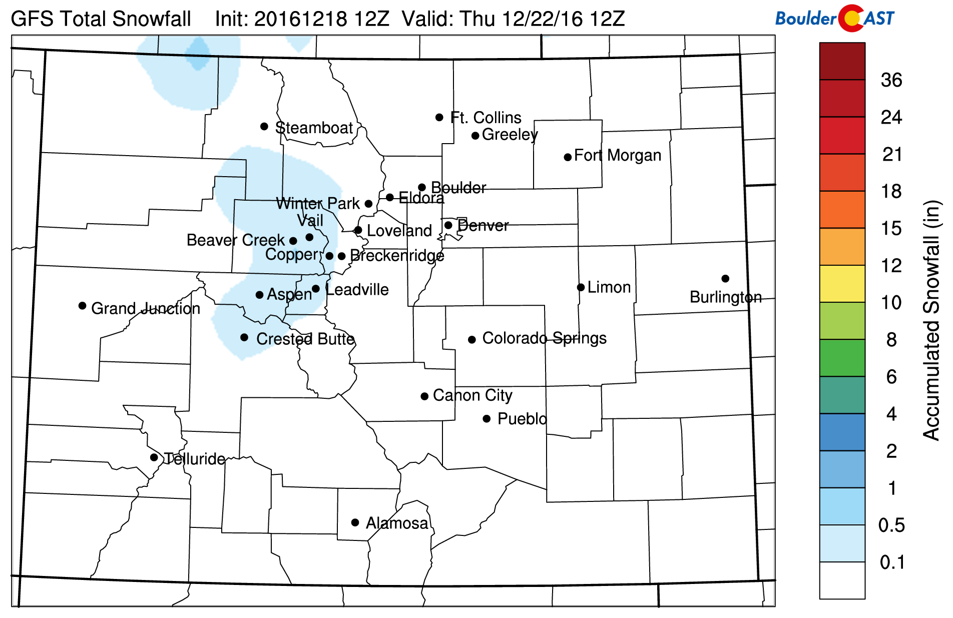
GFS total snow by end of Wednesday
Thursday a little warmer
On Thursday, a weak ridge of high pressure filters in from the west and we will again see a swing in temperatures, this time back to the warmer side. Although the warm-up is not as extensive as it was on Tuesday, we should have no problem getting back into the mid 40’s.
Friday ends with a “watcher”
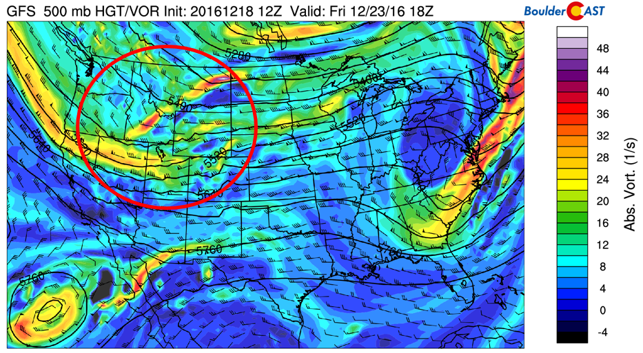
The week ends with rather similar temperatures as it began. However, at some point, we should expect to see another round of Arctic air to slide down from Canada. The area circled in red in the bottom figure shows a broad trough of low pressure extending from California into Colorado by midday Friday. This system will continue to sink southward a be a player for the holiday weekend…more on that below. But on Friday, at this stage of the game, models are forecasting a cold front pushing through mid to late in the day. That timing will likely change as we get closer, but its safe to say we can expect slightly cooler highs Friday than Thursday in the low 40’s, along with increasing cloud cover. The mountains will likely see snowfall in the evening and on Saturday.
Christmas Eve/Day extended forecast
As for the holiday weekend, our eyes are on the aforementioned low pressure system. Below shows its position on Christmas Eve as forecasted by the GFS (see area circled in red). It shows strong development over southern California and northwestern Arizona.
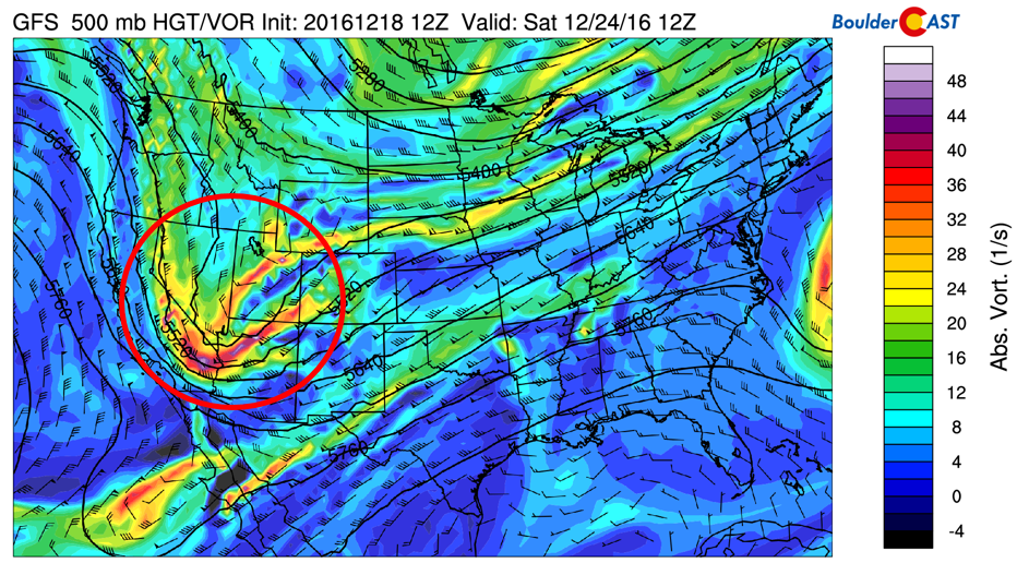
GFS Christmas Eve potential storm system
Current forecasts show this will track northeast Christmas Eve night and into Christmas Day, being a potential snow storm for the mountains and Plains. However, its too far to tell and models are likely to diverge as we get closer to the weekend. This system would also bring down more chilly air, though early indications are that it may not be as cold as what we experienced just recently. Have a great week, “think snow” and have a Merry Christmas whether you are in Colorado or elsewhere!
Oh, and by the way, finally ABOVE AVERAGE mountain snowpack! Hooray!
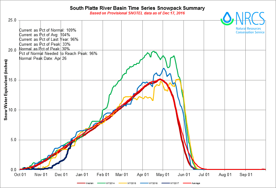
Time series of South Platte River Basin snowpack, now above normal for mid-December!
Forecast Specifics:
Monday: Mostly sunny skies and warmer. Expect low 40’s in most locales of the Plains, low 30’s in the Foothills.
Tuesday: Partly sunny skies. West winds will boost highs to the lower to middle 50’s across the Plains and low 40’s in the nearby Foothills. Gusty winds Tuesday night are possible of up to 45 mph.
Wednesday: Mostly sunny and cold, but not as extreme as we saw this past weekend. Highs near 40 over the Plains and upper 20’s in the Foothills.
Thursday: Mostly sunny and slightly warmer with temperatures in the low 40’s on the Plains and low 30’s in the Foothills.
Friday: Sunny skies, with increasing clouds later in the day. We’re expecting a late week cold front, which will have an impact on Friday’s temperature. Expect highs somewhere in the 40’s for the Plains, and in the 30’s for the Foothills.
High Country: After a ton of snow last week, the mountains to see a short break the first half of this week. A weak system pushes through on Wednesday, with a few inches of snow possible, favoring northwestern Colorado ski resorts. A potentially more potent system is in the forecast Friday and Christmas Eve/Day.
Extended: We are watching the potential for a snow storm on the Plains, Foothills, and mountains Christmas Eve or Christmas Day. It is too far out to detail specifics, but the general trend is for more cold air and a low pressure system to be a player for the upcoming holiday weekend. Once we get closer to the event, we will be sure to update you with an official snowfall map, if conditions are warranted.
Mon
Tue
Wed
Thu
Fri


Temperature
42
53
40
44
43


Precip Chc (Plains)
0%
0%
0%
0%
0%


