Our weather for the week ahead will be dominated by the overhead jet stream. This will provide strong northwest flow throughout the week, bringing more snow to the mountains and a slight chance of snow on the Plains. We’re also tracking a potential wintry event for the tail-end of the week. Continue reading for all the details.
Strong northwest flow through Thursday
We begin our discussion this week with a current look at the jet stream, visible in the 250 mb height and wind map from the GFS model:
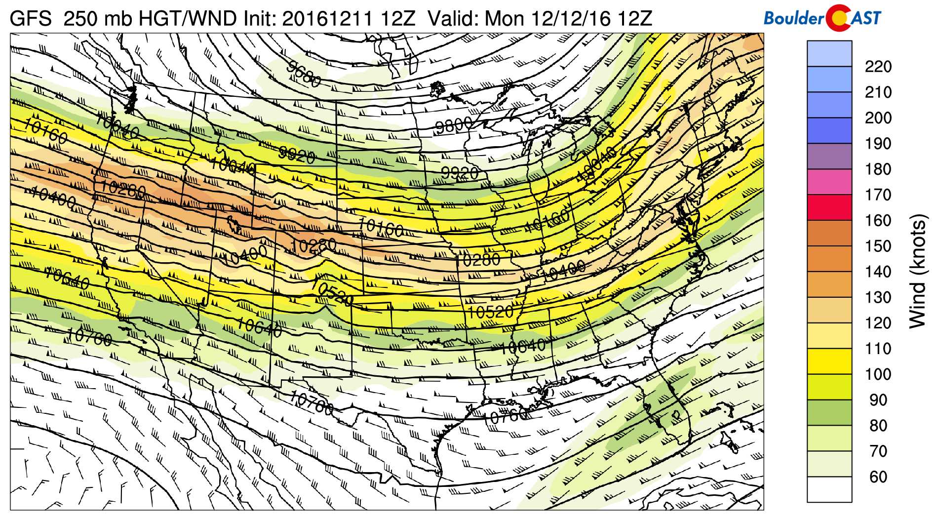
GFS 250 mb heights and winds for Monday morning, showing the jet stream location
The jet is continuous and strong across the entire country, coast-to-coast. West-northwest flow of ~140 knots is present over northern Colorado. This jet will persist through the entire week.
Without looking at anything else from the models, we could tell you this pattern would likely bring good snow to the mountains, generally dry and breezy conditions to the Plains, and near-normal temperatures with the potential for quick shots of cold Canadian air for the Plains. Ignoring the finer details, this is more-or-less accurate for the week ahead.
The 500 mb map from the GFS remains relatively unchanged for Colorado through Thursday as northwest flow dominates.
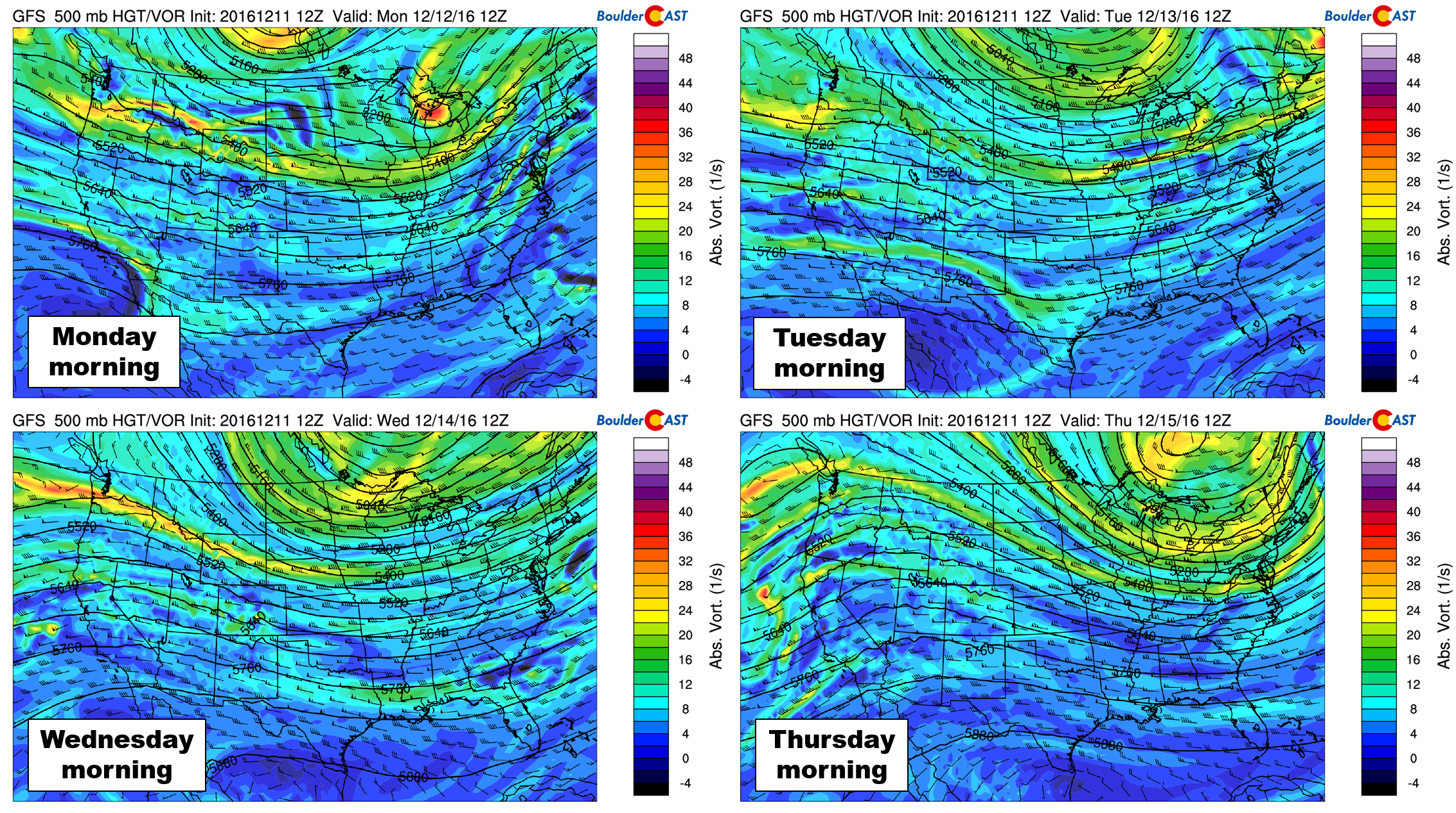
GFS 500 mb maps for Monday through Thursday morning, showing northwest flowing persisting across Colorado during a stagnant weather pattern
There isn’t an overwhelming amount of moisture embedded in the flow, so the snow in the High Country won’t be extreme (moisture increases late in the week, more on that in a bit). The GFS shows moderate snow totals. Our best guess is that most areas above 10,000 feet will be in the 6-12″ range through Thursday evening, with strong winds present throughout the week.

GFS total forecast snowfall for the first round of this weeks mountain snow (Tuesday thru early Thursday)
Down on the Plains, we’ll be on-guard for a few cold fronts punching into northeast Colorado. The first comes Tuesday morning, with the models showing a more significant one arriving Wednesday morning (seen below). After temperatures in 40’s on Monday and Tuesday, Wednesday’s front will be quite cold, likely keeping our afternoon highs in the 20’s.
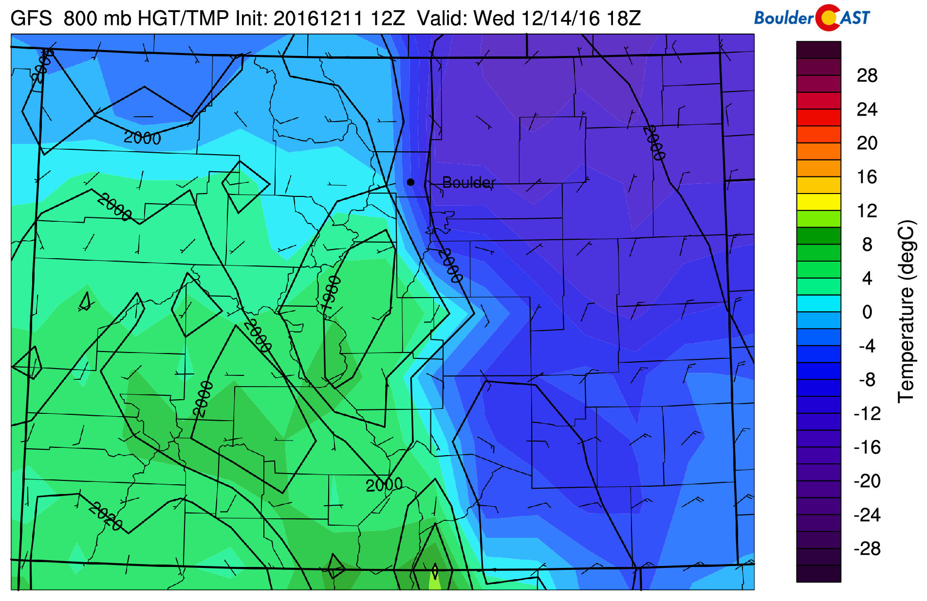
GFS 800 mb temperature and wind map for Wednesday late morning showing cold air banked up against the Foothills, and shallow northeasterly upslope
The push of cold air early Wednesday morning from the north and east will produce shallow upslope, and we do mean shallow. Forecast model soundings cap this upslope at ~750 mb. With this, the potential for much accumulating snow is small. A few flurries or light snow showers may be possible, though. A super subtle feature, which seems to be related to the jet, produces light snow north of Ft. Collins into Cheyenne Wednesday night. Models disagree on its very existence, and it should mostly be to our north if it does happen. Either way, expect a dreary and cold day Wednesday, with a chance of a few snowflakes.
Thursday will see partly sunny skies and temperatures potentially rebounding back into the 40’s as the cold air migrates eastward.
Watching a late-week system
By Friday, our next major weather system will be approaching Colorado from the northwest. The 500 mb map below for mid-day Friday shows the broad trough. Within the large structure of the trough, there appears to be three individual cores of energy. One in eastern Nevada, one in Oregon, and another still offshore from Oregon.
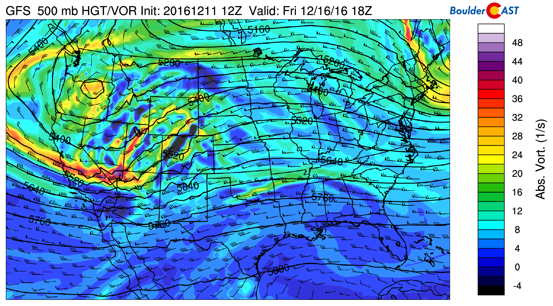
GFS 500mb vorticity map showing a broad trough coming ashore from the Pacific
Five plus days out, it’s hard to say which of these pieces of embedded energy will take point, or even if that may happen. These convoluted scenarios are not easy to forecast this far out.
For example, the latest GFS model runs has Wyoming getting slammed with heavy snow and blizzard conditions Friday into Saturday night, with the Denver Metro getting squat:
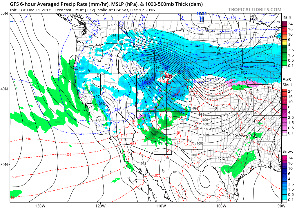
GFS pressure and precipitation forecast for Friday night
The Canadian develops two separate and significant surface lows, one in Montana/North Dakota, and another in Denver, bringing snow to the Front Range Saturday:
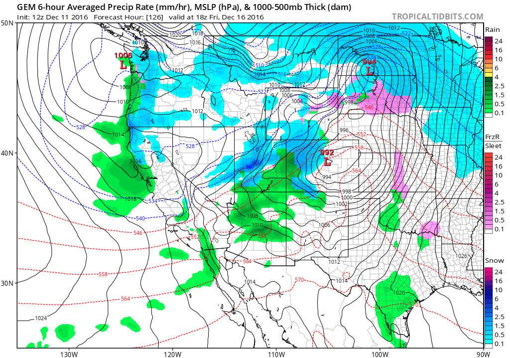
Canadian model pressure and precipitation forecast for Friday night
The European model favors a single storm track right across Colorado, but weaker than the other two models entirely.
We do expect some amount of unsettled weather for late Friday into Saturday, but it is hard to say to what extent with the models all over the place right now. Therefore, we won’t waste too many words on the end-of-week forecast…Friday should be our warmest day of the week ahead of the system regardless. Southwesterly flow and some sunshine will surmount to highs in the 50’s. The Mountains will likely see a significant dumping of snow Friday and Saturday. Stay up to date with our PowderCAST page through the week to help plan the perfect ski day.
We’ll keep you updated if the system at the end of the week eyes northern Colorado. Stay tuned!
Forecast Specifics:
Monday: Partly to mostly sunny and breezy at times. Highs in the mid 40’s for the Plains, with low 30’s in the Foothills.
Tuesday: Partly sunny and a hair cooler. High temperatures near 40 for the Plains, near 30 degrees in the Foothills.
Wednesday: Cooler following the passage of an early morning cold front. Mostly cloudy skies with a slight chance of flurries or light snow showers, especially north of Denver. Little to no accumulation expected for the Plains, with a couple inches possible in the Foothills from Boulder County northward. Highs near 30 across the Plains and mid 20’s in the Foothills.
Thursday: Mostly cloudy and warmer with a late-day high in the mid 40’s for the Plains, and in the low 30’s for the Foothills.
Friday: Our warmest day of the week ahead of our next system. Some sun early, followed by increasing clouds. Rain/snow showers may be possible in the afternoon and evening, depending how the late-week system evolves. Highs in the 50’s for the Plains and in the 40’s for the Foothills.
High Country: After a dry day Monday, snow increases Tuesday evening, lingering through Thursday morning. 5-12″ will be possible is most locations alongside very strong northwest winds. An approaching storm system on Friday will see snow return Thursday night into Saturday. This second round could potentially bring FEET of snow to the ski resorts.
Extended: After the Friday/Saturday storm pulls away, the forecast models are showing a similar pattern for next week with northwest flow across Colorado. With this, we would expect continued mountain snows and seasonal or below normal temperatures for the Plains.
Mon
Tue
Wed
Thu
Fri


Temperature
45
41
28
45
56


Precip Chc (Plains)
0%
0%
20%
0%
20%(pm)


