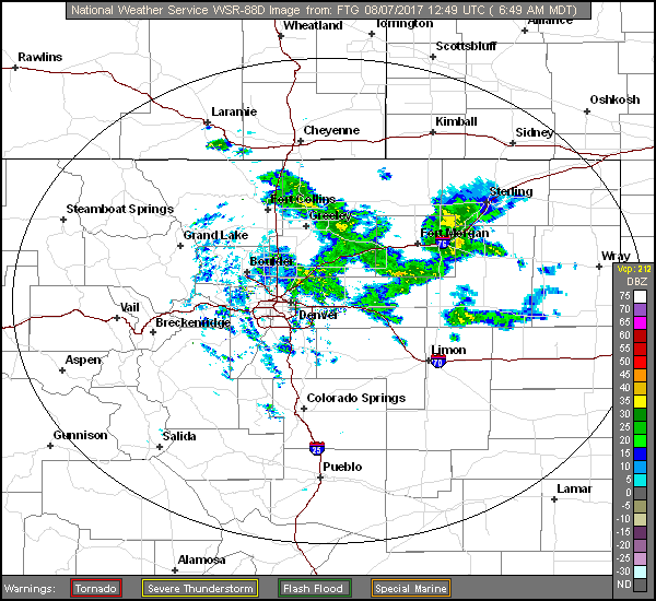
As we begin a first full week of August, we detail the forecast which calls for a rather wet start to our week. Temperatures will be below seasonal averages thanks to cloud cover and precipitation, although a warming trend looks to take hold by the end of the week. Read on for our full weekly outlook.
A wet Monday and Tuesday
The pattern for today shows an area of low pressure near northern California, with west-southwesterly mid-level flow streaming from the Pacific Ocean into Colorado (orange arrow). In this flow, embedded shortwaves will be traversing across Nevada, Utah, and Colorado today and tonight. These shortwaves will produce localized lift in the atmosphere for rain and thunderstorms.
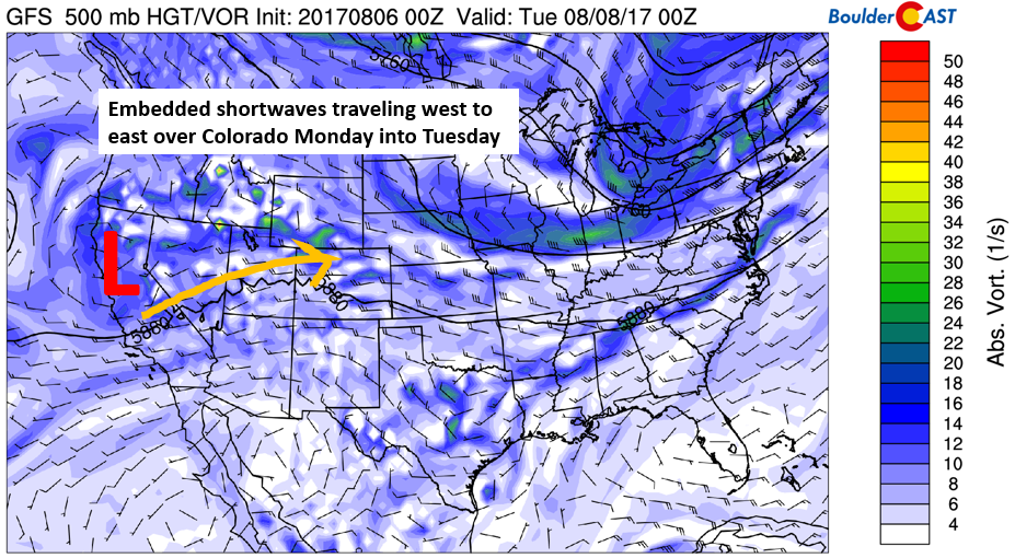
GFS 500 mb absolute vorticity for today showing the track of systems into Colorado
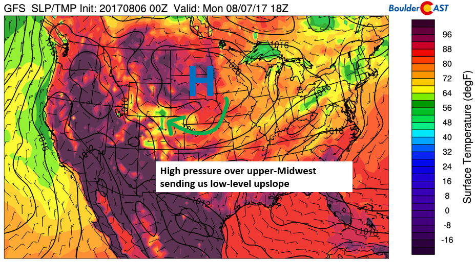
At the surface today is a large area of high pressure centered over South Dakota. Rotating around this is east-southeasterly flow across the Front Range. This combined with upper-level forcing and high moisture content will support widespread rain activity throughout your Monday. Expect low-clouds, fog, drizzle, and on-and-off showers.
GFS surface pressure, temperature, and wind pattern for today
Temperatures today will remain cool beneath the extensive cloud cover…probably in the low to middle 60’s. This is more than 20 degrees below average and will be cold enough for some locations to again set record cold maximum temperatures (similar to that chilly day last week).
The GFS ensemble is indicating the potential for heavy rainfall in localized areas. Below shows a plume forecast of precipitation for the Denver Metro for the week, with today and tomorrow highlighted in red. The biggest spike in rainfall looks to occur today and overnight tonight, with up to an 1″ or more in spots thanks to the possibility of slow-moving thunderstorms. Many factors seem to be coming together for good a healthy dose of rain region-wide.
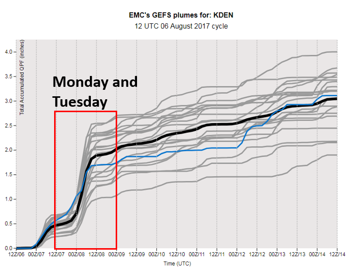
GEFS ensemble plume forecast for precipitation over Denver this week
On Tuesday, much of the same pattern will be in place (below figure). The area of low pressure over California will remain to our west. Meanwhile, westerly flow will also stay across Colorado with embedded shortwaves traversing west to east. As a result, we’re expecting another round of scattered showers and thunderstorms in the afternoon and evening, although not as widespread as Monday. Temperatures should hover in the lower 70’s with some cloud cover and rainy conditions.

GFS 500 mb absolute vorticity for Tuesday
Cold front Wednesday
Models project that a weak area of low pressure over Nebraska will move southeast Wednesday. The end-result is the potential for a weak trough/cold front to push through once again, reinforcing low-level upslope conditions (see below). However, the front is barely noticeable at the surface and only evident 5,000 to 10,000 feet above the surface. That being said, models don’t handle these weak fronts very well a few days out, so the details will likely change as we get closer to Wednesday. Our forecast now is calling for temperatures in the mid to upper 70’s with isolated to scattered thunderstorms in the afternoon/evening hours. It’s very difficult to pin down the location of the storm cells this far out. We’ll update our Premium members as the week progresses. Either way, we don’t think it will be as wet as the beginning of the week.

GFS 700 mb temperature, wind, and height pattern on Wednesday
A similar low-level pattern will exist on Thursday, although we’re expecting more sunshine than earlier in the week. That should help raise temperatures to the low 80’s on Thursday.
Midwest trough on Friday may keep monsoon active
On Friday, a trough is projected to be located over the upper Midwest, with west-northwesterly low to mid-level flow (red arrow below). This pattern will likely keep the region in an airmass that is cooler than normal to end the week. However, we should see temperatures again near the upper 70’s to 80 degrees with morning sunshine. In the afternoon, we’d have to be on the look out for thunderstorms. Though, this far out, it’s tough to say how everything will shake out.

GFS 700 mb temperature, wind, and height pattern on Friday
Forecast Specifics:
Monday: Overcast with low clouds, fog, drizzle, and showers through much of the morning. Heavier rain showers developing by late afternoon with embedded thunderstorms also possible. Watch for locally heavy rain during the overnight hours into Tuesday. Highs across the Plains will be in the mid 60’s with mid 50’s in the Foothills.
Tuesday: Some sun early, then mostly cloudy skies by late morning. Scattered showers and thunderstorms developing late afternoon/early evening. Highs in the lower 70’s across the Plains, with lower 60’s in the Foothills.
Wednesday: Morning sun with increasing clouds during the day. A cold front is projected to reach the area during the late afternoon/evening. This will increase moisture and provide the forcing for scattered thunderstorms which will linger into the the late evening hours. Temperatures will top out in the mid to upper 70’s on the Plains and in the mid 60’s in the Foothills.
Thursday: Mostly sunny in the morning followed by increasing clouds in the mid to late afternoon. Isolated to scattered thunderstorms will be possible in the early evening. Highs look to warm up only slightly to the upper 70’s or low 80’s on the Plains and upper 60’s in the Foothills.
Friday: Partly cloudy with widely scattered afternoon and evening thundershowers. Highs will likely be near 80 degrees for the Plains, with upper 60’s in the Foothills.
High Country: Afternoon heating coupled with embedded shortwaves traversing west to east will focus development of scattered thunderstorms in the higher elevations Monday and Tuesday. Much of the same will exist Wednesday and Thursday. Instability in the atmosphere increases late in the week to continue the threat for high country storm activity. Thus, we expect an active monsoon week for the mountains. Westerly flow will prevail much of the week in the High Country, with sustained winds at times exceeding 30 mph.
Share our forecast:
Mon
Tue
Wed
Thu
Fri


Temperature
64
73
76
78
79


Precip Chc (Plains)
80%
40%(pm)
30%(pm)
20%(pm)
30%(pm)


You must be logged in to post a comment.