After a warm weekend, the chance of thunderstorms returns to the region this week, along with somewhat cooler temperatures. What days will likely see the best chance? Read on to find out. We also discuss the eclipse today and the threat of clouds hampering the viewing party!
A 93% Solar Eclipse with a chance of t-storms today!
The well anticipated solar eclipse takes place late this morning and early afternoon. The eclipse over the Denver Metro is set to begin at 10:23 AM, with maximum darkness at 11:47 AM with 93% of the sun covered by the Moon at that time. The eclipse event ends officially at 1:14 PM. If you are in town for the event and have not ventured to Nebraska or Wyoming, here is a snapshot of today’s forecast.
The map below shows the near-surface wind and temperature pattern today. In green denotes northeasterly upslope flow today as a result of a cold frontal passage overnight last night. While it hasn’t cooled us off much, it resulted in light upslope conditions this morning. In the upper-levels, southwest flow is in place. Today’s satellite image depicts a few high clouds across northeastern Colorado as a result of yesterday’s storm activity in southern Colorado. We expect lots of sunshine this morning and early afternoon for the eclipse, with GREAT viewing overall by the time 11:47 am rolls around with temperatures in the lower 80’s.
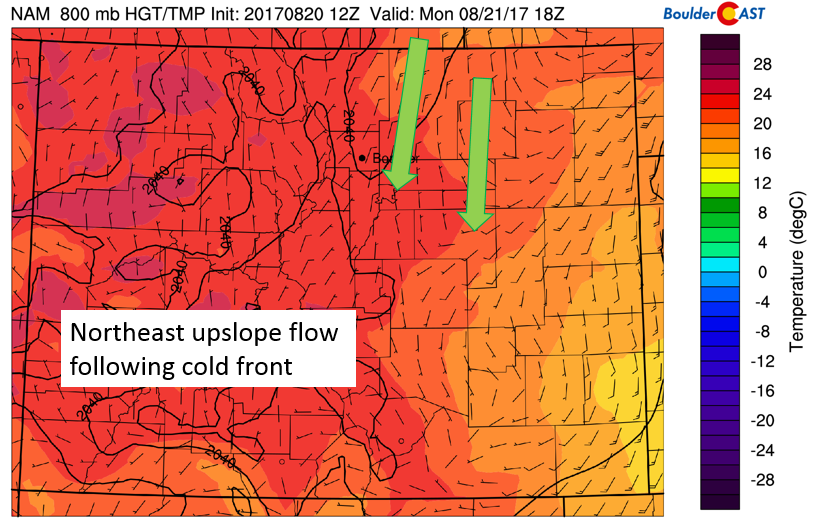
NAM model 800 mb temperature and wind this afternoon
Temperatures Monday should top out in the mid to upper 80’s. Partly cloudy skies will give way to increasing clouds by late afternoon and early evening. For much of the week, the area will be under the influence of a pesky low pressure system off of California (see below) that will bring in monsoonal moisture into the area. Today though, northerly flow is in place so the storms that do form later today and evening should remain mostly confined to our south.
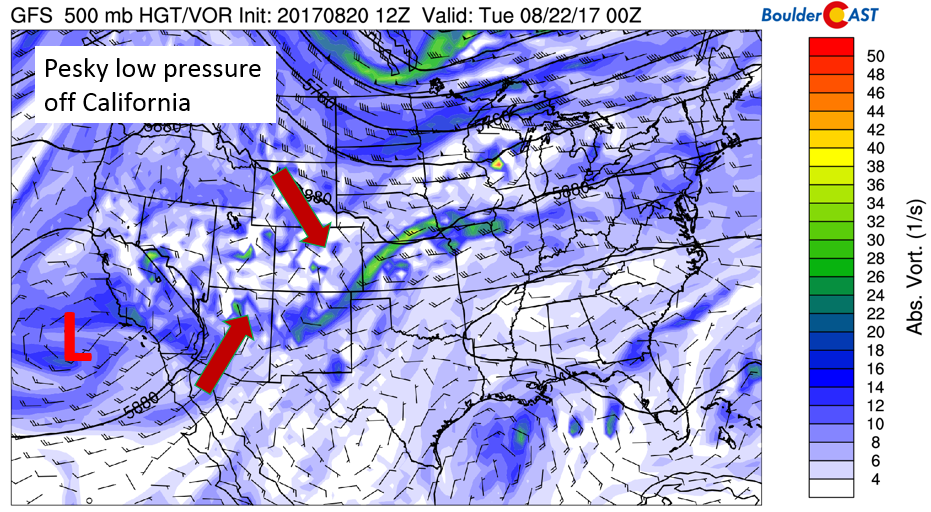
GFS 500 mb absolute vorticity for today
The GFS (below) depicts storms across central and southern Colorado. The chance of storms increases as you move west into the Foothills and High Country.
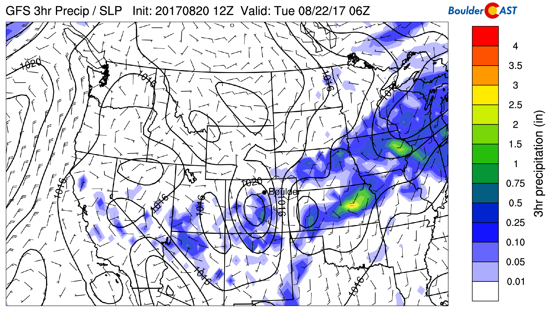
GFS precipitation forecast this evening
Read our official Solar Eclipse forecast for Colorado, Wyoming, and Nebraska:
Best chance of storms Tuesday and thereafter…
Our best chance of rain for the week will likely come Tuesday into Thursday as the low pressure moves inland into California and southwesterly monsoon flow ensues across Colorado. The figure below shows how the low pressure on Tuesday still remains offshore, but that southwest winds push a warm frontal boundary and associated moisture into the state.
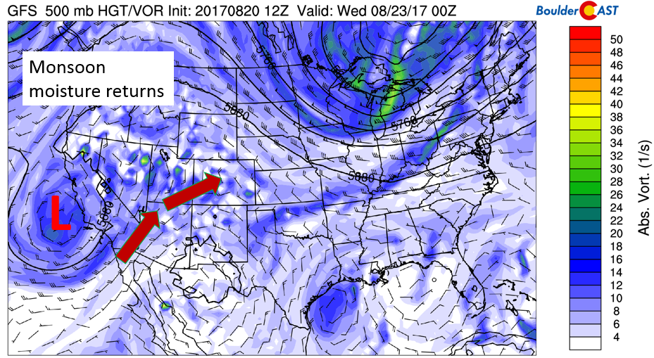
GFS 500 mb absolute vorticity for Tuesday
This flow will likely increase cloud cover on Tuesday and lower high temperatures a tad, so we are expecting partly sunny skies to start – eventually turning to mostly cloudy skies with widespread storms forming over the High Country and Foothills. These storms will drift slowly eastward onto the Plains (see below) and it’s possible some localized areas could see brief heavy rainfall and small hail with associated lightning. Not everyone will see rain but the threat is higher than Monday for sure.
GFS precipitation forecast on Tuesday
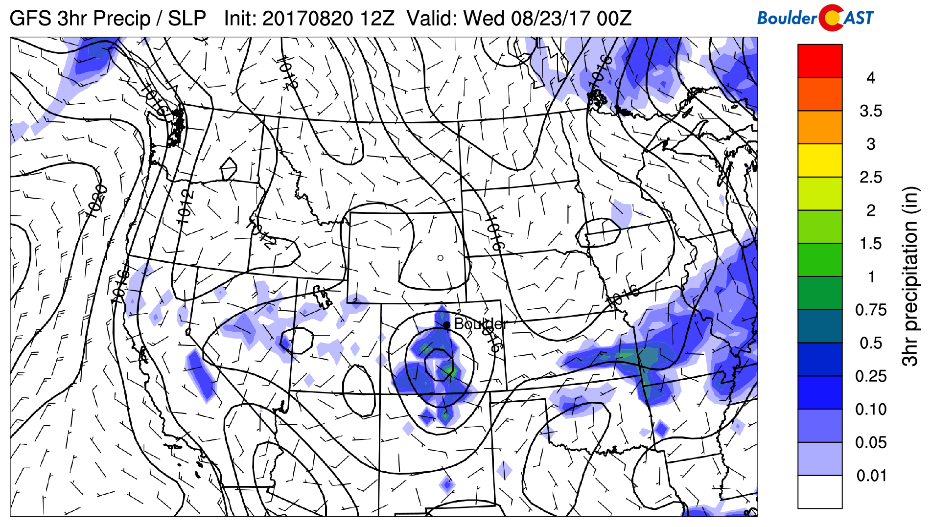
On Wednesday, monsoon flow persists thanks to that low pressure system, finally making its way onshore into southern California. The flow is quite weak in the mid-levels, only some 10-15 mph, so storm activity Wednesday will be slow moving once again. First forming over the High Country, these storms will slowly move onto the Plains in the late afternoon and early evening, with activity being isolated to scattered in nature. We think the chances of rain are similar to Tuesday, with local heavy rain and small hail possible. Sunshine is more prevalent in the early part of the day leading to highs in the middle 80’s.
GFS 500 mb absolute vorticity for Wednesday
Late week maybe stormy, too.
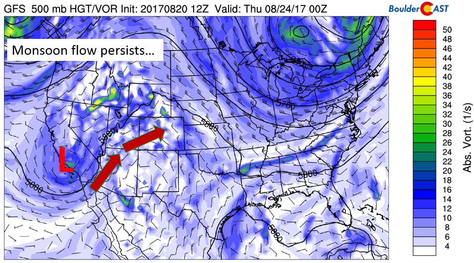
On Thursday and Friday, the aforementioned low pressure system dissipates and becomes entrenched in the mean atmospheric flow. This will lessen our storm chances somewhat to end the week. However, west-southwesterly flow will remain, along with monsoonal moisture. On Friday as well, there are hints of a trough pushing in from the northwest, which would increase lift for unsettled weather. At this point, we are too far out to make a definite conclusion on Friday. Long story short, we are keeping the chances of storms in the forecast Thursday and Friday, at about 20-30% for now, which may be adjusted in subsequent daily forecasts for our Premium members! Enjoy your week and be safe if traveling for the Great American Eclipse!
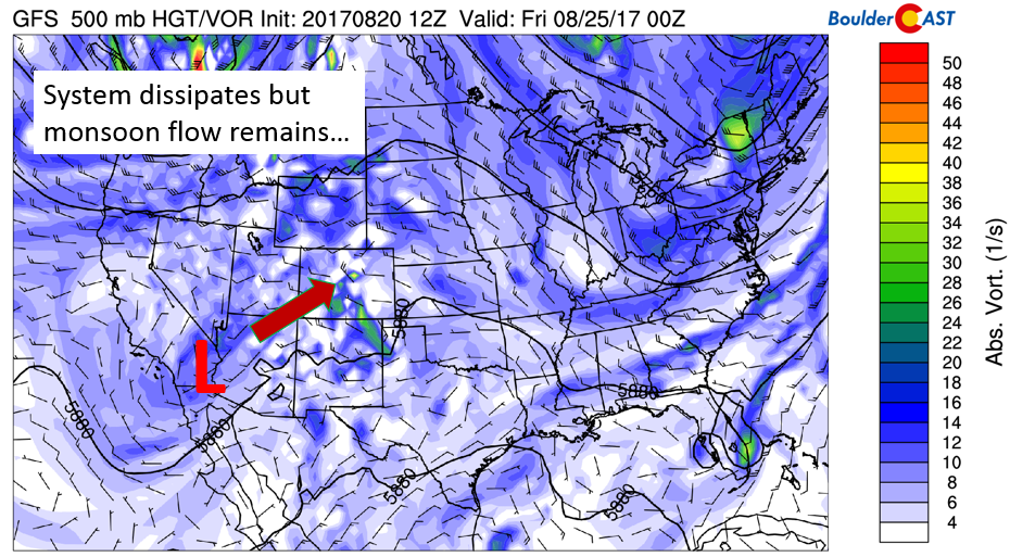
GFS 500 mb absolute vorticity for Thursday
Forecast Specifics:
Monday: A few morning mid and high-level clouds, followed by mostly sunny skies for the eclipse. Increasing clouds in the late afternoon with isolated to scattered storms, primarily in the High Country and Foothills south of Denver. Highs will climb into the mid 80’s on the Plains, with mid 70’s in the Foothills.
Tuesday: Partly sunny skies giving way to mostly cloudy conditions in the afternoon. Scattered thunderstorms developing area-wide with local heavy rainfall and hail the primary storm threats. Storms tapering off before midnight. Highs cooler near 80 across the Plains, with lower 70’s in the Foothills.
Wednesday: Mostly sunny in the morning, then increasing clouds in the mid to late afternoon with isolated to scattered thunderstorms by early evening. Locally heavy rain and small hail are possible. Temperatures in the middle 80’s across the Plains and middle 70 in the Foothills.
Thursday: Lots of morning sunshine giving way to partly cloudy afternoon skies and the chance of isolated thunderstorms. Highs to warm up into the middle 80’s on the Plains and low 70’s in the Foothills.
Friday: Mostly sunny with isolated afternoon and evening thundershowers. Highs will likely be in the 80’s for the Plains, with middle 70’s in the Foothills.
High Country: The chance of thunderstorms will be present each day over the mountains and Foothills. The best days to hike look to be Monday anytime and during the hours before noon-time. Tuesday through Thursday will be the days in which the threat of storms will be the highest.
Share our forecast:
Mon
Tue
Wed
Thu
Fri


Temperature
84
80
84
83
85


Precip Chc (Plains)
30%(pm)
40%(pm)
40%(pm)
20%(pm)
20%(pm)


