
As we rapidly sprint towards the end of meteorological summer and the conclusion of Colorado’s wet season, the weather for the week ahead will not sway much from what we have come to expect. Chances of rain will be there, but not substantial. We’re also tracking yet another fall-like cool-down just in time for the weekend. Continue reading for our outlook for the upcoming week.
We won’t spend too much time this week recapping the continuance of dry weather across the region. Just know that in the last week, most areas in the Denver Metro area and Foothills experienced rain at least three times. However, storms were rather weak and it didn’t amount to all that much, with virtually no where exceeding 0.25″. The surge of moisture supplied by now-dissipated Tropical Storm Javier wasn’t enough to help northern Colorado. On the contrary, the southern portion of the state received more significant rainfall last week.
Things aren’t looking good for the Front Range. We’ll leave it at that, for now…

Month-to-date rainfall for the Denver Metro area (through August 14)
Mostly dry & warm to begin the week
Looking to the week ahead, the recipe remains quite similar to the one Mother Nature has been cooking up for the last month or more. On paper, chances for rain will exist across all of Colorado each day. However, no day appears remotely close to being a “sure thing.”
The 500 mb pattern on Monday is shown below. Notice the trough to our east in Missouri, a ridge across Colorado, and another weak trough in northern Nevada.
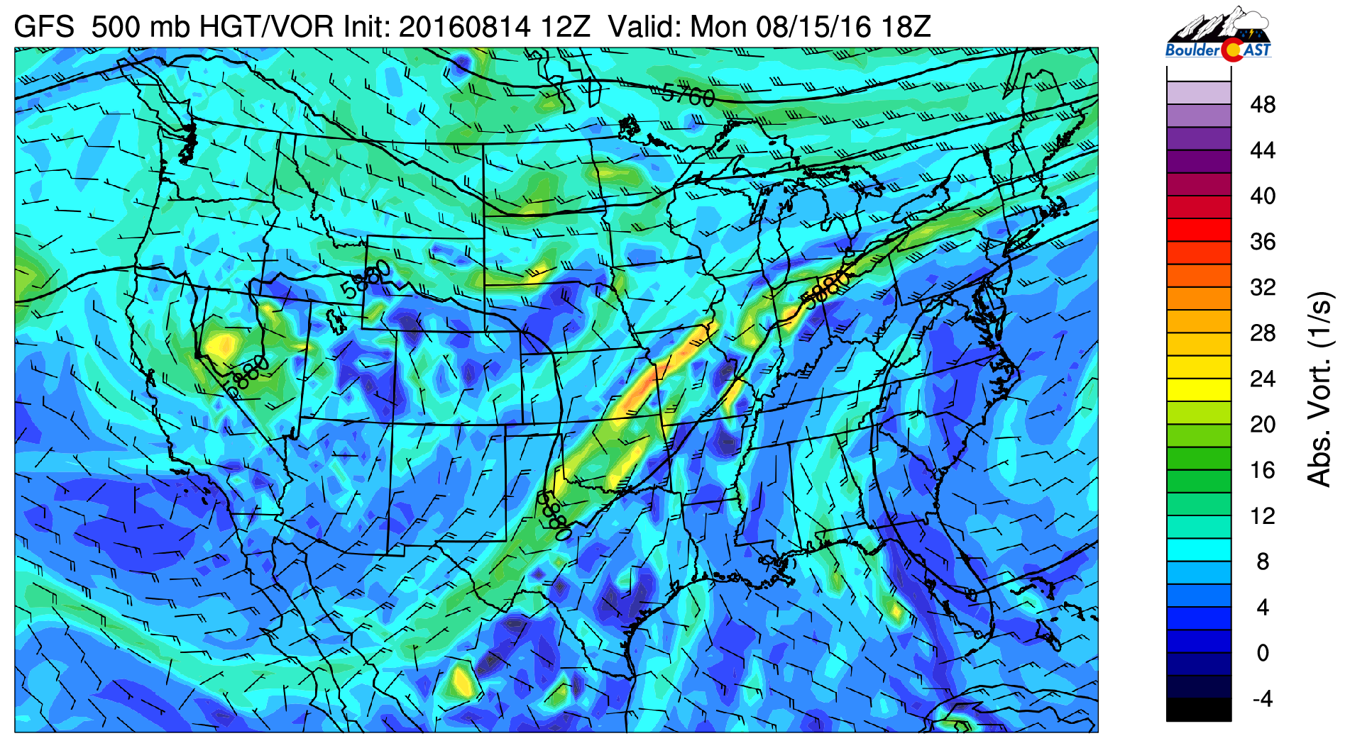
GFS 500 mb vorticity map for Monday showing ridging across Colorado
A ridge over Colorado is nothing new, but as they say, “Winter is coming!” The general weather pattern is starting to become more active. With summer beginning to wrap-up, we should see this trend continue over the next several weeks for the continental United States.
With that ridge overhead and limited moisture to work with, today will be hot and mostly dry across the region. We can’t rule out a few isolated storms across the Foothills, but the atmosphere on the Plains is hostile. Any storms that attempt to move eastward should dissipate, not producing much more than a few sprinkles and some brief gusty winds. Expect a high in the upper 80’s.
Shortwaves of plenty
For the period of Tuesday through Thursday, at least two shortwave disturbances will trek across Colorado, helping to enhance moisture, cloud cover, and ultimately rainfall across the region. Unfortunately, they are all quite weak and disorganized, so we’re not very confident of any soaking rains just yet. In fact, they are so disorganized, it’s difficult to pick them out on most of the 500 mb forecast maps. They can been seen in Tuesday morning’s map below, however.
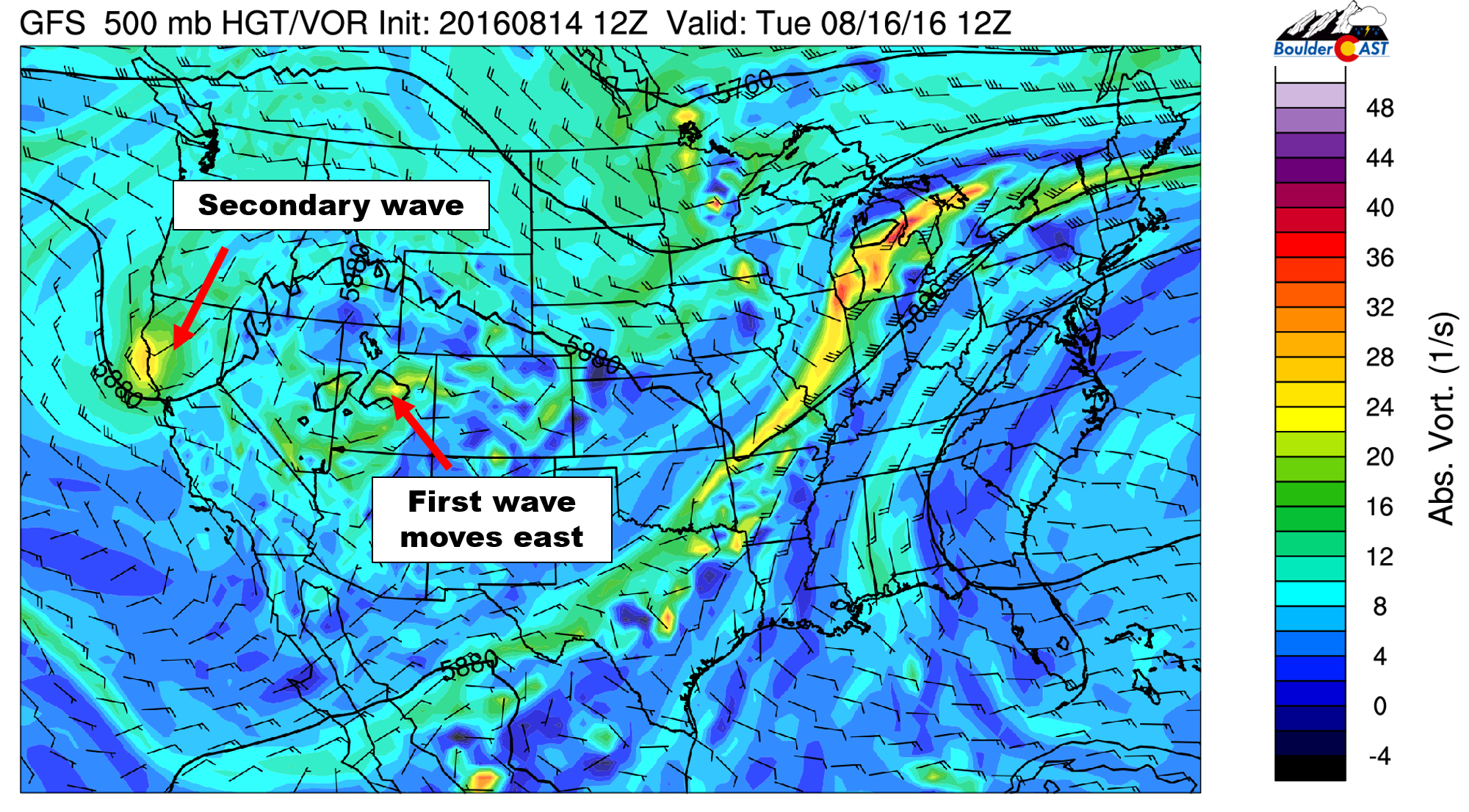
GFS 500 mb vorticity map for Tuesday morning, showing two shortwave systems lining up to impact Colorado
The first is set to impact northern Colorado Tuesday evening into Wednesday, with the second not far behind for Thursday. Moisture during this time-period will fluctuate on both the wet and dry sides of normal (Wednesday’s moisture anomaly is shown below). Nothing looks overly impressive, but with afternoon heating, isolated to scattered storms will develop each day, especially in the higher elevations.
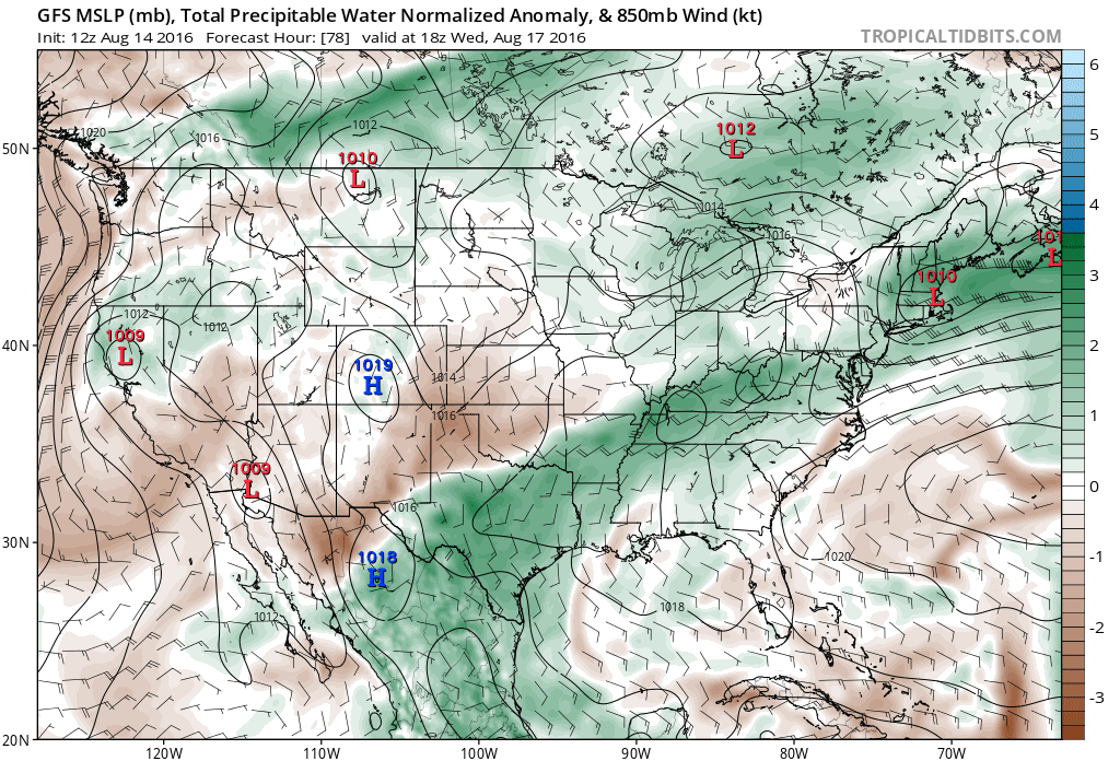
GFS forecast moisture anomaly for Wednesday afternoon
Temperatures for Tuesday through Thursday will be near normal. Look for highs in the mid 80’s each day. Expect morning sunshine with increasing clouds during the afternoons.
Cool and (potentially) rainy to end the week
By week’s end, the models are in relatively good agreement that a more substantial system will impact the Northern Rockies. Timing is a little questionable (as it always is five days out), but we’re expecting a trough to swoop in with cooler temperatures for Friday and the upcoming weekend.
The 500 mb vorticity map (depicted below on the left) shows this expansive trough, with a core located over central Canada. The figure on the right shows the associated colder air, which by Friday morning, is already filtering into Colorado from the north.
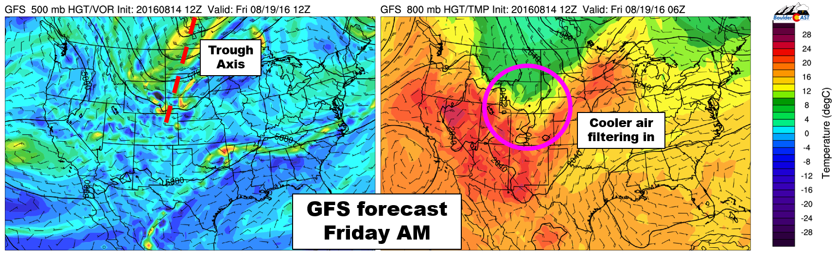
GFS forecast for Friday morning, showing a large-scale 500 mb trough (left) and an associated cold front penetrating northeast Colorado (right)
We won’t speculate too much on the specifics of what may happen to end the week. However, if the timing and magnitude of the system does play out as it looks now, we’re looking at much cooler temperatures (somewhere in the ballpark of 70 degrees for highs) and greatly increased shower/storm chances late Thursday night through late Friday night as upslope flow ensues across the Front Range.
Forecast Specifics:
Monday: Sun early with isolated storms in the afternoon and evening, primarily across the higher elevations. Highs in the upper 80’s over the Plains and mid 70’s in the Foothills.
Tuesday: Sunny skies giving way to partly sunny conditions with widely scattered afternoon/evening storms for everyone. High temperatures in the mid 80’s for the Plains with mid 70’s in the Foothills.
Wednesday: Increasing clouds with widely scattered afternoon and evening thunderstorms. Highs in the mid 80’s on the Plains and mid 70’s in the Foothills.
Thursday: Partly cloudy with scattered late-day thundershowers. Some storms could continue through the night as the front passes. Highs in the low to mid 80’s on the Plains and low 70’s in the Foothills.
Friday: Behind and overnight cold front, expect cooler weather, dreary skies, and scattered showers. Some clearing could take place during the afternoon. High temperatures in the low 70’s for the Plains with low 60’s in the Foothills.
High Country: Storm chances will exist over the Mountains throughout the entire week. The highest threat will be Tuesday through Thursday. Friday looks like it could be quite wet in the Mountains, but lightning chances should be lower with a more stratiform/upslope pattern in place.
Extended: The upcoming weekend looks to see storms continue for the region, especially in the High Country. Temperatures rebound a little compared to Friday, but will likely remain below normal for this time of year. We’re seeing some signs that subtropical moisture could be returning sometime next week. Don’t place any bets yet, though. Monsoon season is rapidly winding down.
Mon
Tue
Wed
Thu
Fri


Temperature
89
87
85
84
73


Precip Chc (Plains)
10%
30%
20%
40%
50%


