
The last seven days have been quite dry across Boulder and the Denver Metro. We have also seen swings in temperature from the 90’s to the 80’s with a few frontal systems. This first week of August will start off warm in the 90’s, with a transition to cooler weather by week’s end. Wait until you see how chilly we are forecasting for Friday! Thunderstorms will be possible each day, although our best shot appears to hold out until the end of the work-week. Read on for this week’s full forecast.
Bone dry!
Below shows the total accumulated precipitation from the last seven days, ending on July 31st. Circled in red is Boulder and Denver. At best, we have only gotten a trace to a tenth of an inch in most locations, with the exception of Longmont at around 1/4 to 1/2″. Most of the rain has fallen to our north and east, with some spots seeing 1-3″ of rainfall. It’s not a surprise why there is a fire ban in effect over much of our state. We could really use some rain both on the Plains and the higher elevations! The forecast this week looks promising for rain…
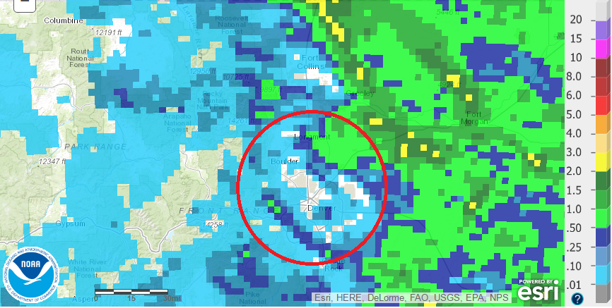
NOAA/NWS observed precipitation from the past 7 days
Monday is hot with isolated storms
The current mid-level flow and 500 mb vorticity shows a weak ridge of high pressure situated near the Four Corners region, with west-northwesterly flow aloft. This northerly flow will bring in drier air from the north with moisture decreasing compared to Sunday. The airmass is very similar, albeit slightly warmer than Sunday, so expect highs again in the lower 90’s in most locales, with some middle 90’s near the Denver Metro.
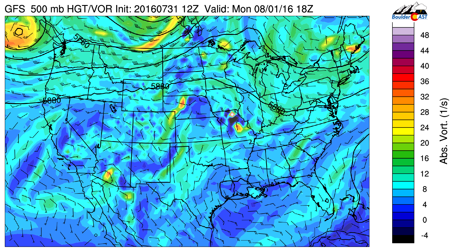
GFS 500 mb vorticity and mid-level flow for today
With dry air filtering in from the north, thunderstorms that form today will be isolated and spotty at best. Below is the total moisture content in the atmosphere this evening. It shows a decrease with the northerly flow. However, some light upslope with a weak cold front sliding down from the north, coupled with weak instability, will help fire off a few isolated storms. Don’t expect much in Boulder or Denver. Best chance looks to be over the High Country in southwestern Colorado where the moisture is more substantial.
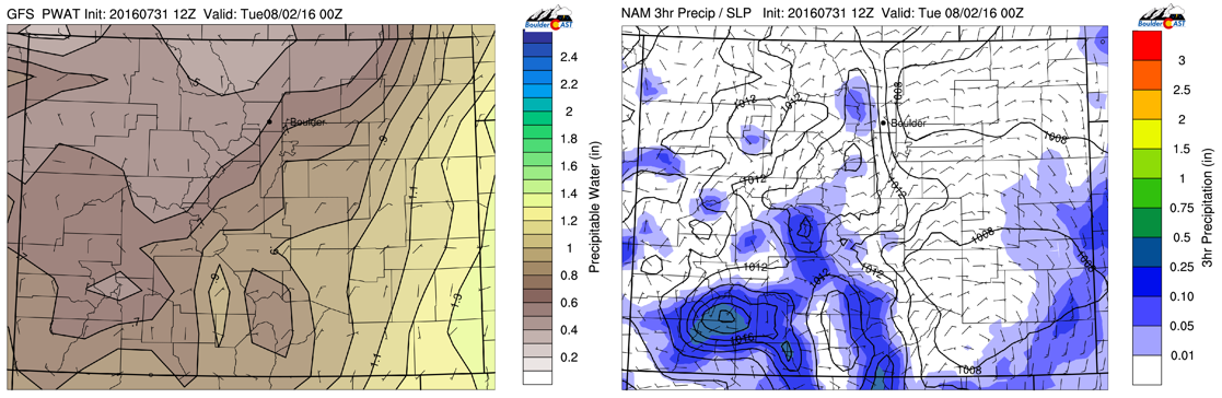
GFS Precipitable water (moisture) at left and NAM 3-hr precipitation this evening (right)
“Slightly” cooler Tuesday…
A very weak cool front slides down Monday night into Tuesday. It is very tough to pick out in the models. Most evident is a shift in the low-level flow from southwest to southeast at 700 mb (see below). As a result, 700 mb temperatures cool only “slightly”. This should shave off a few degrees on highs from Monday, but we’re still looking at temperatures close to 90 on the Plains for Tuesday.
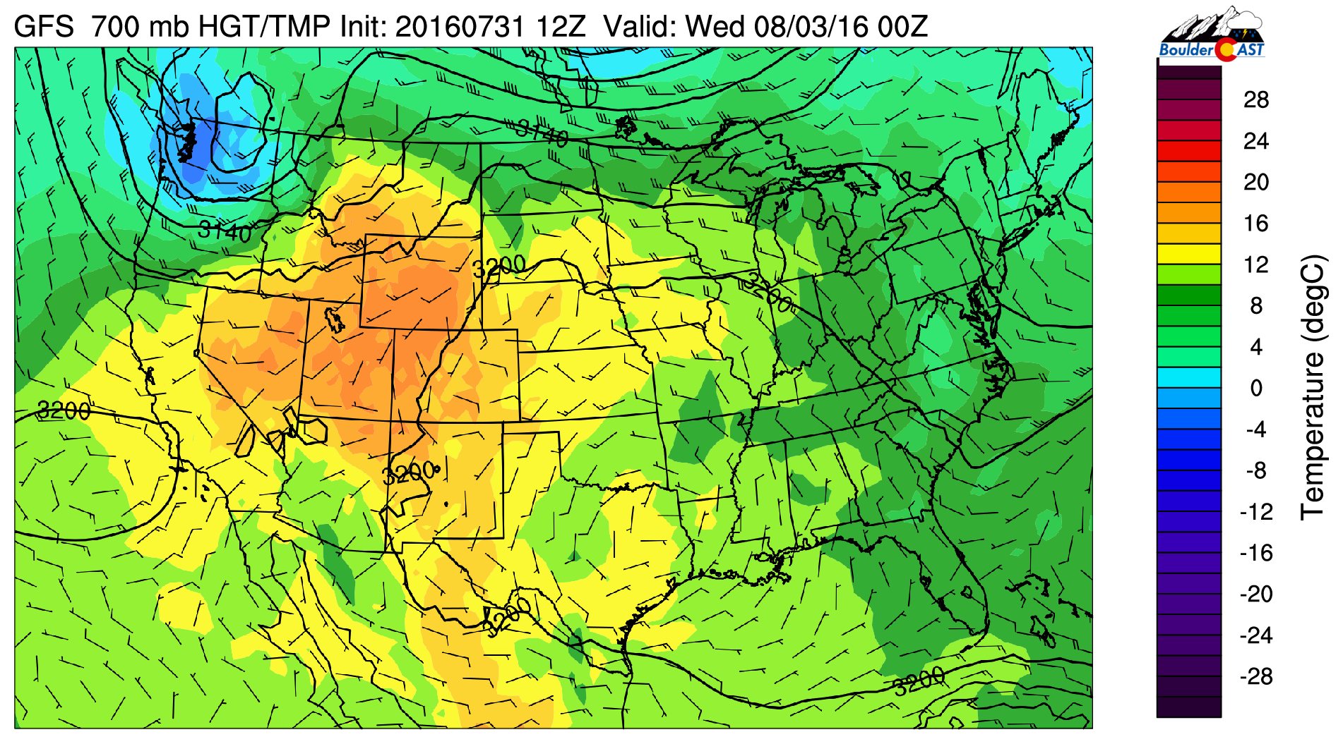
GFS 700 mb temperature for Tuesday over the U.S.
Storm chances on Tuesday are slightly elevated with the weak surface boundary ushering in southeasterly flow at the surface and a little more moisture. Best chance of storms in the High Country and western Foothills, with only a few storms making their way onto the Plains.
GFS (left) and NAM (right) 3-hr precipitation Tuesday evening
Wednesday is our hottest day!
Wednesday will likely be the hottest day of the week for us. The 700 mb temperature below shows values as high as 19 degrees Celsius tied to the ridge centered over Colorado at 500 mb. We’re expecting highs to reach the middle 90’s after the brief reprieve Tuesday. Note an area of low pressure well to our north in Canada. This will be the focus for Thursday and Friday.
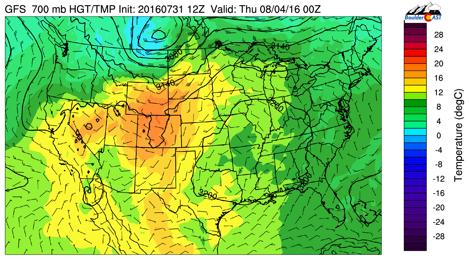
GFS 700 mb temperature for Wednesday
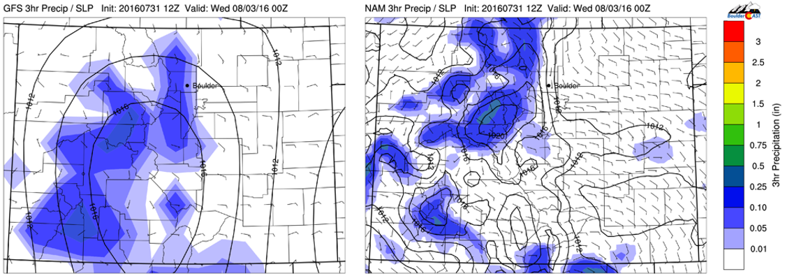
As for storm chances, the models again paint the best areas for thunderstorm activity over the High Country. With moisture increasing a little, some of these storms could move onto the Plains. But again, isolated storms will be the norm with the Foothills seeing the best chance.
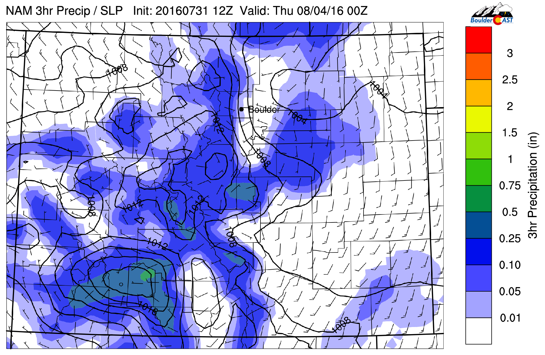
NAM 3-hr precipitation for Wednesday
Thursday and Friday cooler and wetter…
Thursday and Friday will be a transition from the hot weather to below normal temperatures into the lower 80’s and eventually 70’s. Very early on Thursday morning, the aforementioned low pressure system over Canada (small red circle) will push a cold front down from Wyoming into northeast Colorado. This is denoted by the arrow north of our state. At the same time, a broad trough over California (large red circle) and the ridge pushing east into Texas/Oklahoma, will bring in subtropical moisture beginning Thursday and increasing into the weekend. This will lead to our rain threat being highest to end the week.
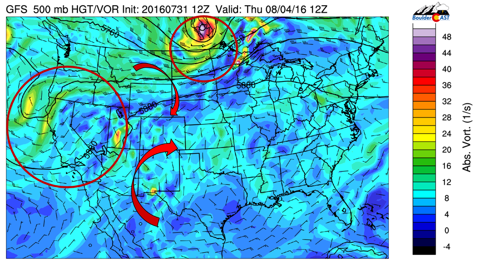
GFS 500 mb vorticity and mid-level flow for Thursday morning
Even almost 5 days out, both the Euro and GFS models are consistent on a strong cold front pushing down early Thursday with the aforementioned large-scale pattern. The cold front in both forecast models is shown below using blue solid lines and arrows. A close-up of Colorado using the GFS shows a clearer picture of the frontal location draped along the Foothills, with northeasterly upslope flow and cooler air behind. We’re expecting highs near 80 on Thursday.
Cooler air will further sag south into Friday as the trough over California shifts southeast and 700 mb temperatures cool down further with the northerly flow, so Friday could see highs in the middle 70’s. However, a slight shift in the strength, intensity, and position of the front could change the forecast Thursday and Friday.
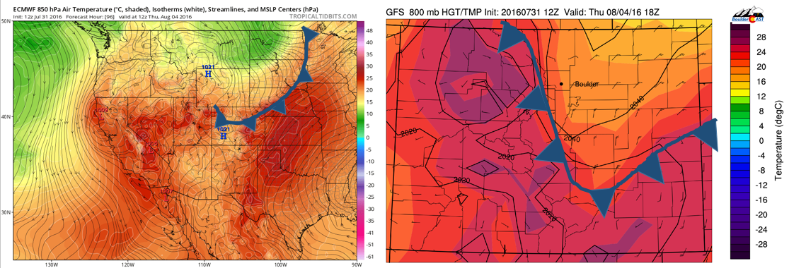
ECMWF 850 mb flow and temperature (left) and GFS 800 mb temperature and wind over Colorado (right) for Thursday
Precipitation, as mentioned at the beginning of this post, will be best Thursday and Friday, with several factors combining to increase this threat.
- the upslope flow with the cold front previously mentioned.
- subtropical moisture returning with precipitable water values near 1.3″ on Friday
- a series of shortwaves pushing in from the southwestern U.S. into Colorado with the California trough, rotating around the ridge (see above 500 mb figure with arrows).
The GFS paints a “wet” pattern both days to end the week with rain looking to finally spread east onto the Plains.
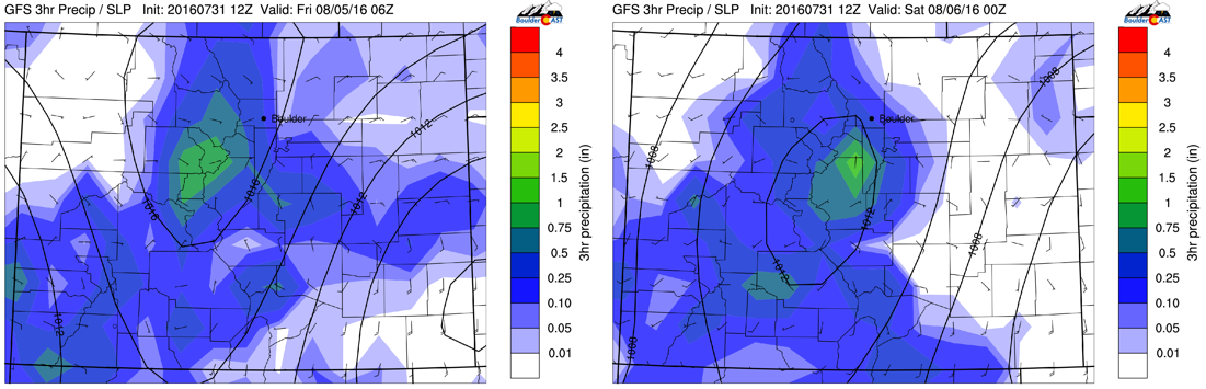
GFS 3-hr precipitation for Thursday (left) and Friday (right)
The total accumulated precipitation for the week predicted by the GFS is shown below. The majority of this predicted rainfall occurs in the latter part of the week. If the GFS is correct, portions of the Foothills and Plains could see 1-3″ of rain. Although this is just a model prediction, it is promising nonetheless.
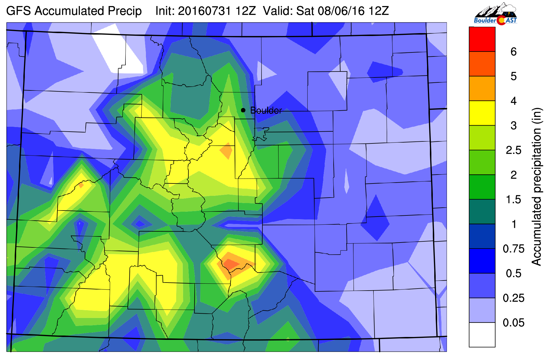
GFS total accumulated precipitation for the week
Extended outlook:
The extended forecast into the weekend is shown via the Euro model below. It shows the broad trough over California still present, along with a ridge more to the east of Colorado in Oklahoma. This pattern looks to continue our “monsoon” flow into the weekend with thunderstorms staying in the forecast, especially for the High Country.
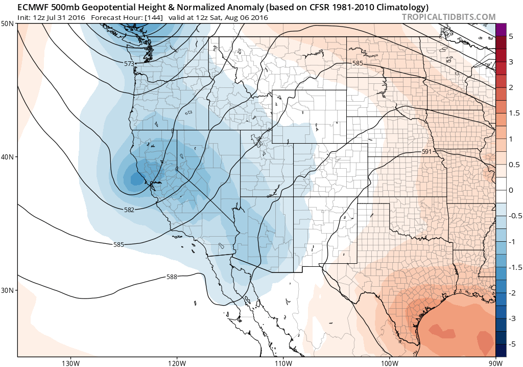
ECMWF model forecast for the weekend with anomalous 500 mb heights
Forecast Specifics:
Monday: Mostly sunny skies with partly cloudy skies in the afternoon and evening. Highs in the lower 90’s over much of the Plains and lower 80’s in the Foothills. Isolated storms in the Foothills and Plains but overall dry.
Tuesday: Sunny skies giving way to partly sunny skies with isolated afternoon/evening storms. Highs near 90 over the Plains and upper 70’s in the Foothills.
Wednesday: Mostly sunny skies, then increasing clouds with isolated to scattered afternoon/evening storms, primarily over the Foothills. Highs in the middle 90’s on the Plains and middle 80’s in the Foothills.
Thursday: Much cooler, sunny skies, followed by mostly cloudy skies and thunderstorm activity state-wide by evening and overnight. Highs near 80 on the Plains and upper 60’s in the Foothills.
Friday: Partly sunny skies becoming mostly cloudy with widespread showers and storms possible. Highs near the middle 70’s on the Plains and middle 60’s in the Foothills.
High Country: Storm chances will exist over the Mountains throughout the week. The highest threat will be from Wednesday through Friday, say about 50-60% during this time frame.
Extended: Storm chances look to stay elevated over the Plains through the weekend with a monsoon flow, with temperatures warming as well back into the 80’s.
Mon
Tue
Wed
Thu
Fri


Temperature
93
90
96
80
76


Precip Chc (Plains)
10%
10%
20%
40%
50%


