
After a gorgeous reprieve Sunday, we return to a colder and more active pattern we have all become accustomed to. The first half of the week will be influenced by another area of low pressure that will bring rain/snow to the region. The rest of the week from Wednesday onward will see a pleasant warming trend. Read on for our full weekly outlook.
Monday starts out calm, ends cold and active
Below is the current state of the atmosphere today in the mid-levels. Shown is an area of low pressure over southern Nevada. The yellow arrow depicts the flow, indicating west-southwest winds over Colorado.
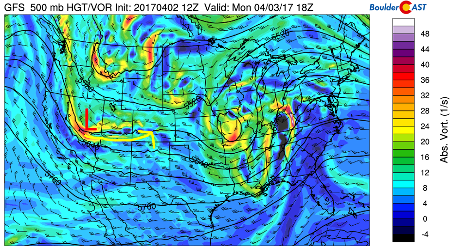
GFS 500 mb vorticity map for this afternoon
Over the next 24 hours, the aforementioned storm system will track into northern New Mexico (see below), with moisture wrapping around the system into southern Colorado. The track of this storm is eerily similar to last Friday (i.e. TOO FAR SOUTH). However, it appears that this event has slightly more colder air to work with. Secondly, the track has trended slightly north in the past few forecast model runs, giving us slightly more confidence that the Denver Metro should see snow this time. For our detailed storm forecast, check back for our updated post later this morning.
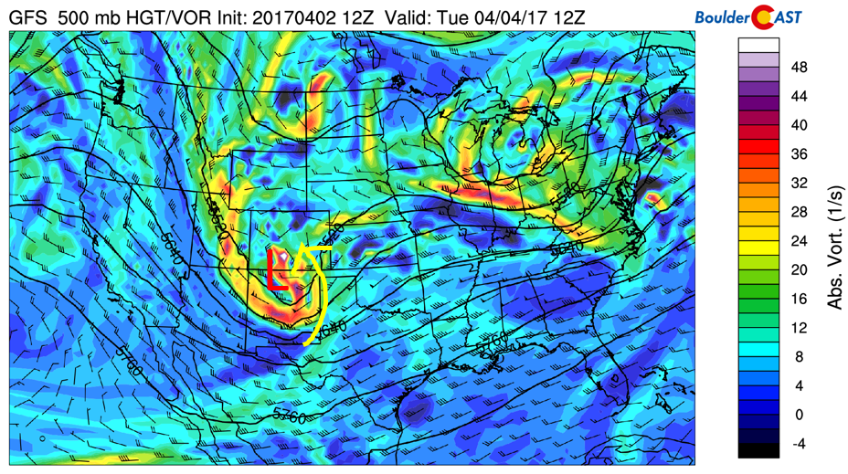
GFS 500 mb vorticity map for Tuesday morning
Generally speaking, we’re thinking 1-3″ for the Denver Metro area, with 6-12″ for the Mountains and 3-8″ in the Foothills. Best day to ski fresh powder will be Tuesday and Wednesday! For today, we’re expecting middle 50’s to start the day, with a gradual cooling trend by this evening.
Below shows the week ahead as a time/height plot of temperature, wind, and relative humidity. The area highlighted in red depicts the storm today into tomorrow. Northeast upslope flow is evident, with below freezing temperatures in the upper 20’s Tuesday morning. By Wednesday, westerly flow takes over under a ridge of high pressure (more on this below), spelling out warmer weather the remainder of the week.
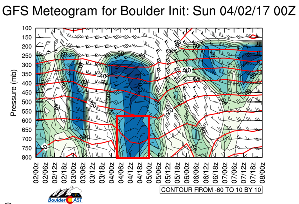
GFS time/height plot for the storm
Tuesday is cloudy, snowy, and cold
On Tuesday, the low pressure system will be impacting the area, with light snow in the morning, then tapering off by afternoon. We will start out in the upper 20’s to 30 on the Plains. With the low pressure system resulting in upslope flow across the terrain, cloud cover will be with us throughout the day, keeping temperatures only in the middle to upper 30’s for highs over the Denver Metro. Clouds will stick around until midnight, becoming partly cloudy thereafter. This clearing will allow for below freezing temperatures again, potentially in the lower 20’s if the snowfall comes to fruition.
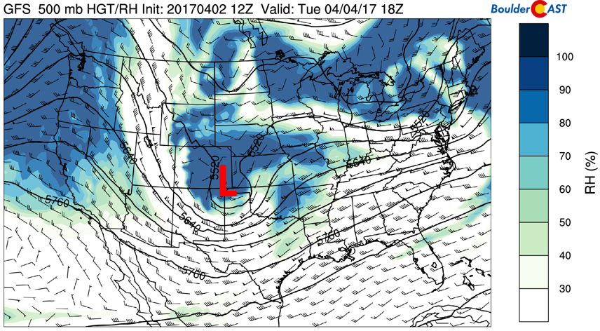
GFS 500 mb relative humidity for Tuesday
Wednesday through Friday to see warming trend…
By Wednesday, the storm pulls off to our east into Missouri, as depicted below. Behind it, a ridge of high pressure, with its axis over Idaho, slowly makes its way eastward. We can expect some morning clouds on Wednesday under west-northwest flow. If snow cover is around from the storm system, we’re expecting highs near 50. If, however, the snow does not materialize, highs will be a bit warmer.
GFS 500 mb mid-level flow for Wednesday
The ridge axis continues its eastward movement Thursday, centered over western Colorado.
GFS 500 mb mid-level flow on Thursday
On Friday, the ridge is forecasted to be over eastern Colorado. This pattern shift will allow for a pleasant warm-up to end the week. On Thursday, a weak and shallow cold front will reach northeastern Colorado, but will only impact the area in terms of southeasterly flow. We should see low 60’s Thursday and near 70 on Friday!
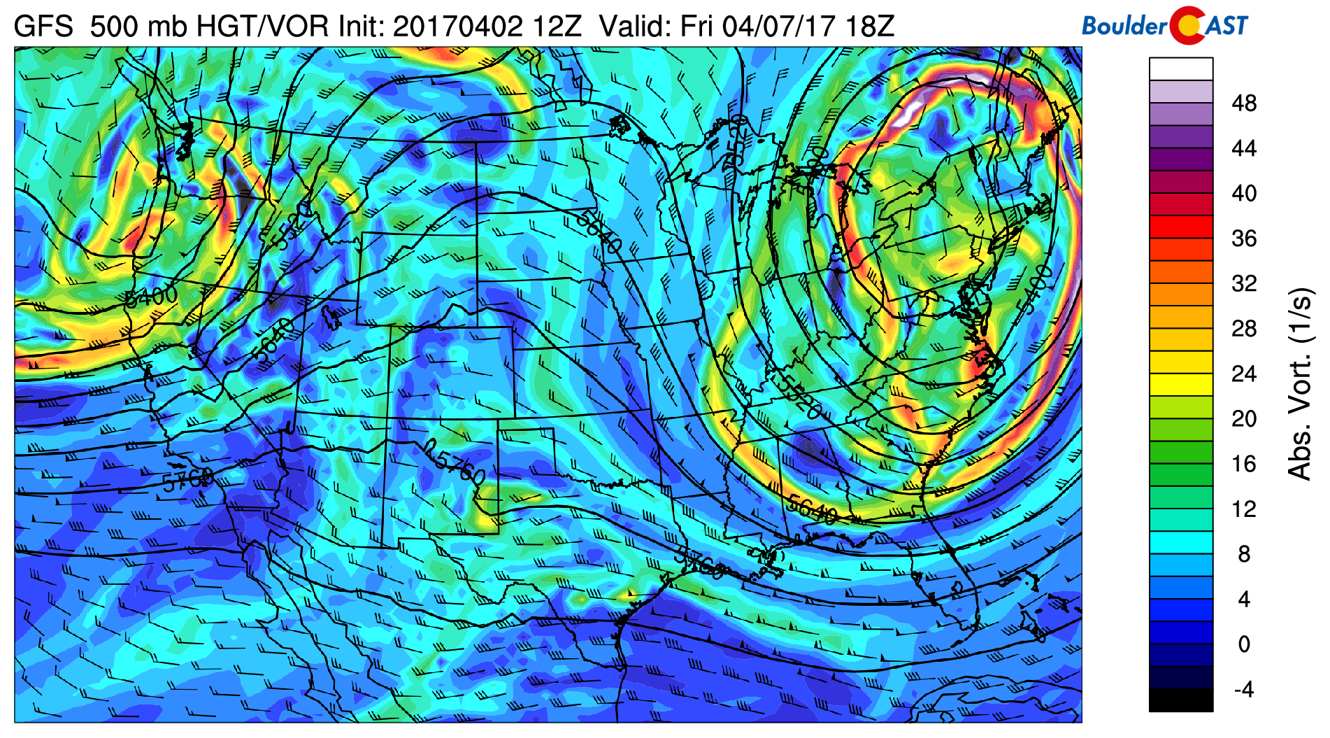
GFS 500 mb mid-level flow for Friday
Forecast Specifics:
Monday: Mostly sunny early, then increasing clouds in the afternoon. High temperatures in the middle 50’s on the Plains and middle 40’s in the Foothills. Light rain/drizzle begins after sunset tonight, changing to snow around or slightly after midnight. Accumulation amounts of 1-3″ by Tuesday morning across the Denver Metro, with slightly more in the Foothills and areas south of Denver.
Tuesday: Light snow in the morning, then overcast skies. An additional 1-2″ of snow is possible in the morning for the Plains and 2-4″ in the Foothills. Highs in the middle 30’s on the Plains and upper 20’s in the Foothills. A hard freeze is likely Tuesday night with temperatures in the lower 20’s. Cover up your plants!
Wednesday: Morning clouds, then partly cloudy in the afternoon with highs near 50 degrees for the Plains and lower 40’s in the Foothills.
Thursday: Mostly sunny and warmer with highs in the lower 60’s on the Plains and low 50’s in the Foothills.
Friday: Sunny and gorgeous with temperatures near 70 on the Plains and lower 60’s in the Foothills.
High Country: Snow will spread into the High Country Monday and Monday night and persist into Tuesday. Southwest and southern Colorado look to be favored early in the day Monday, with central Colorado favored Monday night into Tuesday. Accumulations of 6-10″ is possible across several ski resorts, with a foot or more in localized spots. After Tuesday, high pressure settles in, with gradual warming and dry weather for the remainder of the week. The best days to ski fresh powder will be Tuesday and Wednesday!
Extended: The extended outlook is less certain at the moment. While both the ECMWF and GFS models are showing a large trough to impact California Saturday night and Sunday, this trough is likely not going to impact our region until early next week at the earliest. At this point the storm looks to be a player for the High Country with some decent snowfall once again.
Mon
Tue
Wed
Thu
Fri


Temperature
55
37
53
62
70


Precip Chc (Plains)
60%(pm)
60%(am)
0%
0%
0%


