
Following a stretch of warmer weather, an active storm track returns to close out the month of April. With it comes cooler temperatures and increased precipitation chances through the week. Our biggest concern is the potential for another spring storm late in the week. Read on for our complete outlook.
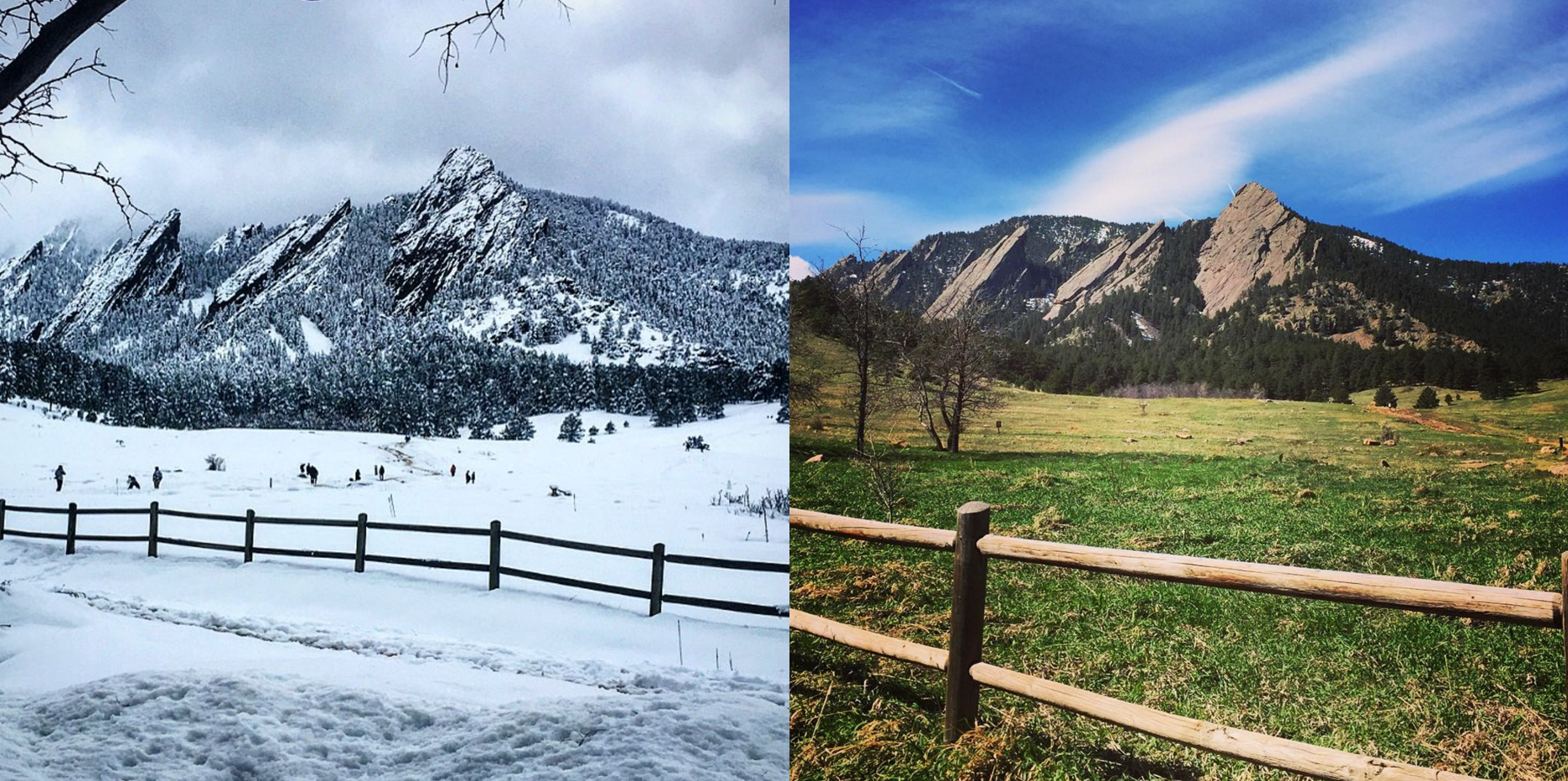
The photo on the left was taken last Sunday, following 18″ of fresh snow. The one on the right taken three days later: green grass and cirrus clouds, with barely any indication of the troubled weather a few days prior. What a difference a few April days can make in Colorado!
The focus for the week ahead will be a broad trough which sets up across the western United States. It will remain entrenched across the region, guiding storm systems towards Colorado. This will make for an overall unsettled weather week.
Spotty rain/snow through Wednesday
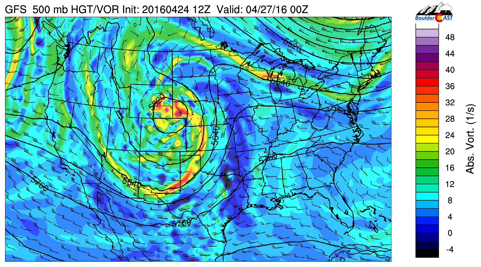
The first wave of the trough arrives this evening, visible below in the 500 mb GFS vorticity forecast.

GFS 500 mb vorticity map for this afternoon. SW flow ahead of the trough will fuel the fire for a few isolated storms today.
Southwesterly flow ahead of the trough will bring higher moisture content, enough to produce isolated showers/storms this evening and overnight into Tuesday, mostly over the higher terrain and north towards the Wyoming border. There could be a few storms across the Plains near Denver though. With partly sunny skies, highs will top out in the upper 60’s this afternoon.
Models continue to show this system tracking just to our north, which mostly downslopes the Denver Metro area, and keeps most of the precipitation north of Fort Collins and in Wyoming. We’re right on the cusp of it, though. Any track shift southward would produce an uptick in precipitation tonight.
The system will be centered over southeast Wyoming Tuesday evening (seen below).
GFS 500 mb vorticity map for Tuesday evening. The center of the system is to our north (not favorable) for much precipitation
With the trough nearby, Tuesday and Wednesday will be dreary across the Plains. There will be spotty showers around, but neither day will be a wash-out by any means. Expect hit and miss showers, accompanied by below normal temperatures and mostly cloudy to overcast skies. Tuesday will be in the upper 50’s, while Wednesday will fall a few degrees cooler.
There is the potential for some higher elevation snow Tuesday into Wednesday with cooler air aloft. That would likely be confined to areas above 7,500 feet, and just a couple inches at most. Here is the NAM forecast snow amounts through Wednesday morning… 2-5″ for most of the ski resorts is a safe bet.
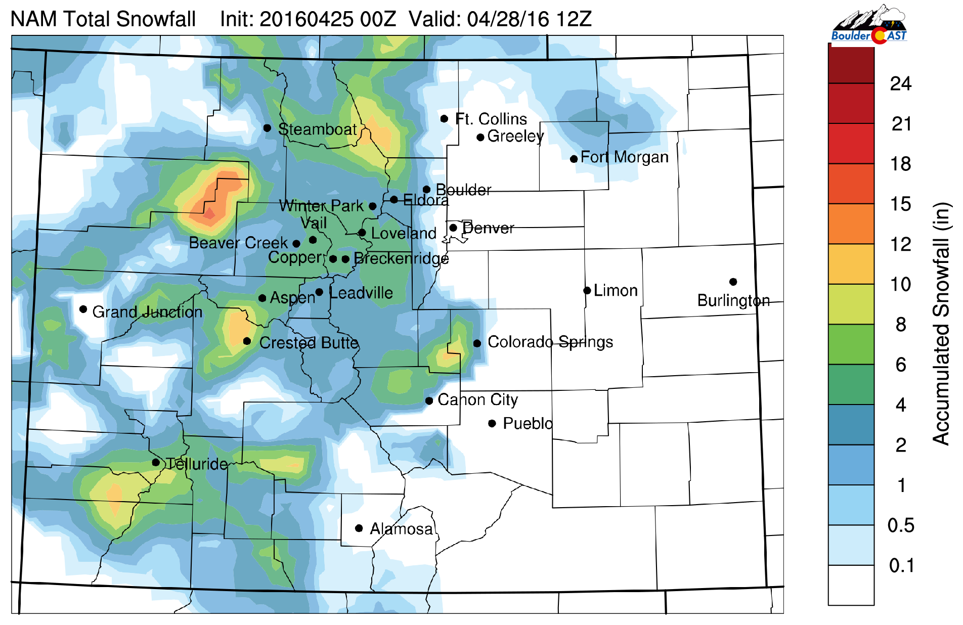
NAM total accumulated snowfall forecast through Wednesday morning
Another spring storm to end the week?
Things get interesting as we head towards the end of the week as a secondary trough moves ashore. This one looks to be taking a more southern track, which would be more favorable for precipitation across the Front Range. Slow storm progression is also a concern.
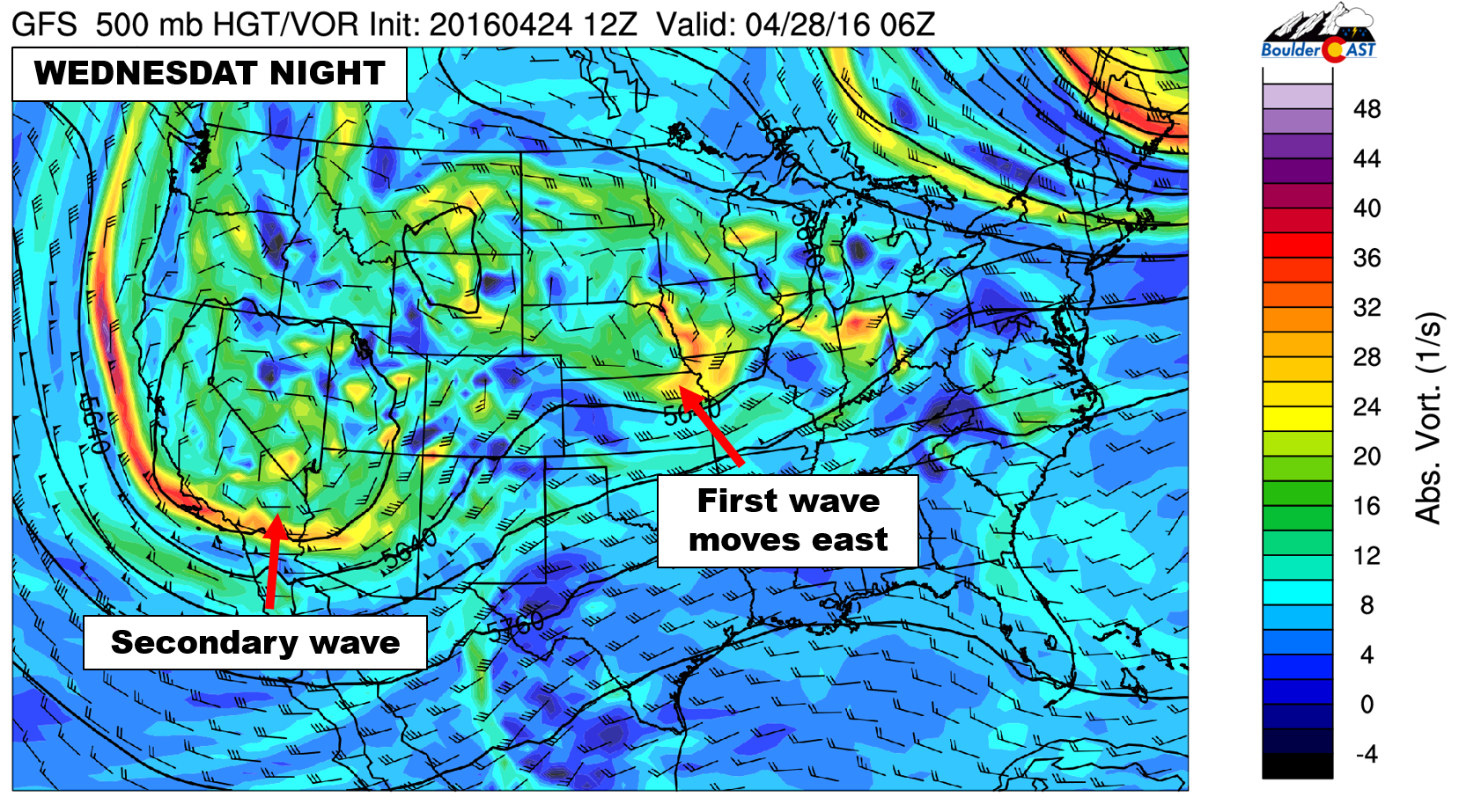
GFS 500 mb vorticity map for Wednesday night, showing a secondary wave coming ashore in California
It’s still four to five days out, and as of now, the models aren’t in very good agreement, but the potential exists for significant precipitation from Thursday afternoon into Saturday as a surface low develops in southeast Colorado.

GFS pressure and precipitation forecast for Friday afternoon, showing a powerful spring storm spinning across eastern Colorado, with widespread precipitation across the Front Range
Models are generally producing 1-3″ of precipitation across Boulder/Denver for this event. Snow levels will be high through Thursday, mostly above 8,500 feet. Then, on Friday, the models show some colder air, enough to lower snow levels down into the 7,000-foot range. There isn’t any real indication for accumulating snow on the Plains right now, but we’ll be sure to keep you updated. Concern is definitely there for the higher Foothills, however.

GFS total precipitation through Saturday morning, showing the potential for significant precipitation across the Front Range
This system is far too uncertain at this point to say anything definitive. For now, plan on very cool temperatures (low 50’s for afternoon highs) and a high likelihood of overcast skies and rain showers (with some snow above ~7,000 feet) on both Thursday and Friday.
Happy Monday! Try to make the best of the ugly weather-week ahead!
The Forecast:
Monday: Increasing clouds with isolated showers and storms in the evening and overnight, mostly over the Foothills and north of the Denver Metro area. Highs in the upper 60’s across the Plains, with upper 50’s in the Foothills.
Tuesday: Cloudy with scattered showers through the day. A couple inches of accumulating snow will be possible above ~8,000 feet through Wednesday. Highs in the upper 50’s for the Plains, with mid 40’s in the Foothills.
Wednesday: Mostly cloudy and dreary. Scattered rain/snow showers across the Foothills, with isolated showers for the Plains. A few wet snowflakes mixing in (but no accumulation) may be possible early Wednesday for the lower elevations. Highs into the middle 50’s across the Plains and middle 40’s in the Foothills.
Thursday: Chilly and overcast, with widespread rain showers possible, particularly in the second half of the day. High temperatures in the lower 50’s on the Plains and lower 40’s in the Foothills. Snow levels begin high, near 9,000 feet, but come down a bit Thursday night into Friday.
Friday: Cloudy and cold. Fair potential for a significant rain (snow above ~7,500 feet) during the day and overnight into Saturday. Highs in the upper 40’s on the Plains, mid 30’s in the Foothills.
High Country: Spotty showers and a few storms will be present each day through Wednesday. Snow levels will be high, above 9,500 feet, lowering to around 8,500 feet by Wednesday morning. Look for 2-5″ for the ski resorts through Wednesday. The threat of heavy snow increases Thursday into Friday as the secondary system approaches. Too early for any amounts, but Friday and Saturday are looking like good powder days for the Front Range Mountains!


