
After a gorgeous weekend with sunny skies, the weather turns more active this week with a series of storm systems moving through, along with a general trend of colder weather each successive day. This is all thanks to the jet stream meandering southward. Read on for our weekly outlook, including whether we may see snowfall on the Plains late in the week…
Snowfall review of last week’s storm
A Pacific storm brought rain and snow to the region Thursday night into Friday night last week. We were expecting all rain on the Plains, with some light snow in the Foothills. 0.3 to 0.8″ of benficial precipitation was recorded across the region, with 1 to 4″ of snow above 7,000 feet in the Foothills.
Shown below is our original snowfall forecast map created Thursday morning. The observed storm totals per location are contained in boxes. Green ones indicate that the observed snowfall was within one inch of the given forecast range, while red was outside the scope of our forecast.
Generally things played out as expected and all locations landed within our forecast ranges.
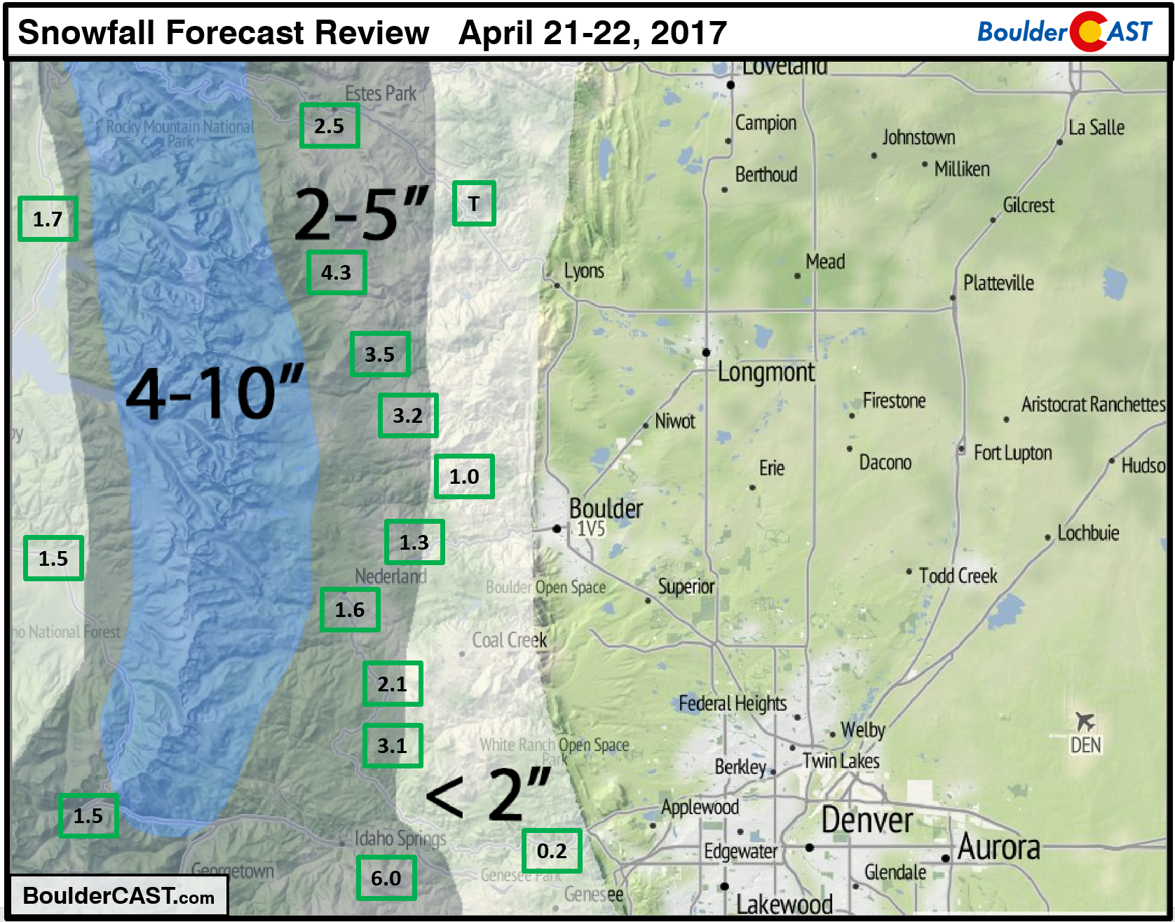
No snow was recorded in Boulder, so our “Late Season” snow total remains zero for the contest….
General trend for the week
Below shows an overall weather outlook for the week for the Denver Metro via a time/height plot of temperature, winds, and relative humidity. Due to the jet stream sagging southward this week, several weather impacts will occur, highlighted accordingly. Circled in black is a region of high relative humidity in the mid and upper-levels of the atmosphere. This remains with us through much of the week, spelling out lots of off and on cloud cover thanks to moisture pumping in from the Pacific Ocean. Circled in red highlights two cold fronts pushing in from Wyoming Monday and Tuesday, which will start our downward trend in temperatures. And, finally, the orange box denotes a potential late week strong storm which could produce both rain and snow for the Plains and High Country.
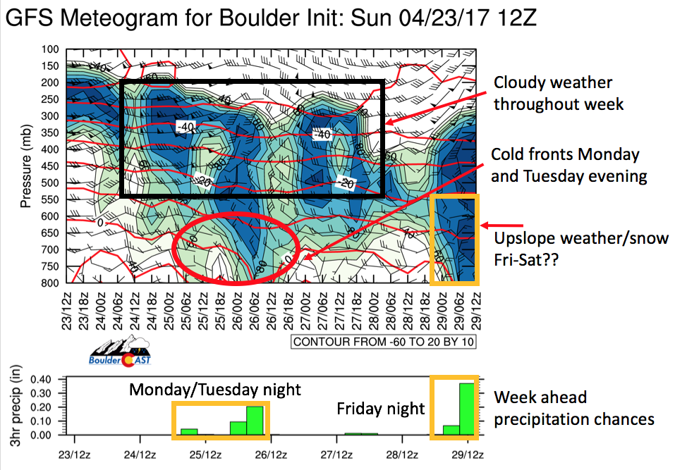
GFS model time-height plot of relative humidity (shaded), wind speed (vectors), and temperature (red lines), along with forecasted precipitation for the Denver Metro area Monday through Friday this week
Monday starts mild, cloudy, and windy
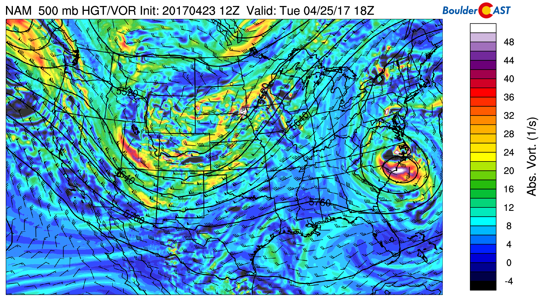
The mid-level atmospheric flow for today is depicted in the NAM model forecast below. Two areas stand out. First, a strong area of low pressure in the southeastern United States over Georgia. Second, a broad trough over the Pacific Northwest, with westerly flow extending around the base of the trough over Utah, Colorado, Wyoming, and the Great Plains. A second wave of energy tied to this trough is over northwestern Nevada. It will be moving eastward tonight, leading to snow showers in the High Country with a few inches of accumulation expected. Over the Plains, the chance of rain is fairly slim thanks to downslope flow. Though, we can’t rule out some isolated showers Monday evening and night.
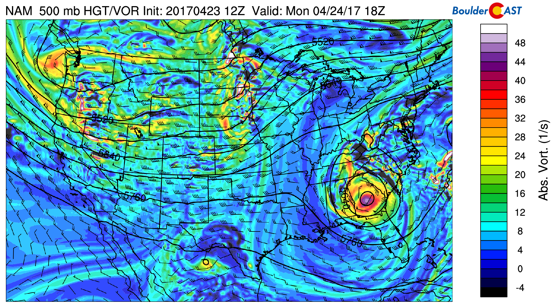
NAM 500 mb absolute vorticity and height pattern today
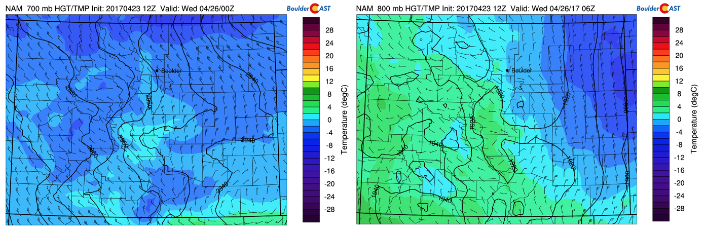
Monday starts out windy and cooler compared to Sunday. The bottom two figures show the mid and low-level height, temperature, and wind pattern. Tightly packed height contours (black) are centered around Boulder, pointing to strong downslope flow. This is the reason for our gusty morning with winds at times exceeding 30 mph. We expect these winds to decrease through the day with temperatures rising to the upper 60’s. Keep in mind what we noted earlier that conditions should remain quite cloudy, with the jet stream and associated shortwave bringing in high clouds from the west.
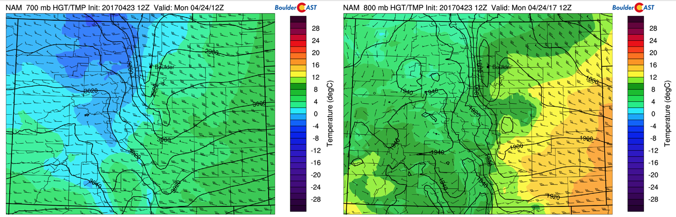
NAM model 700 mb (left) and 800 mb (right) temperature, wind, and height for this morning
Tuesday chilly with rain chances elevated
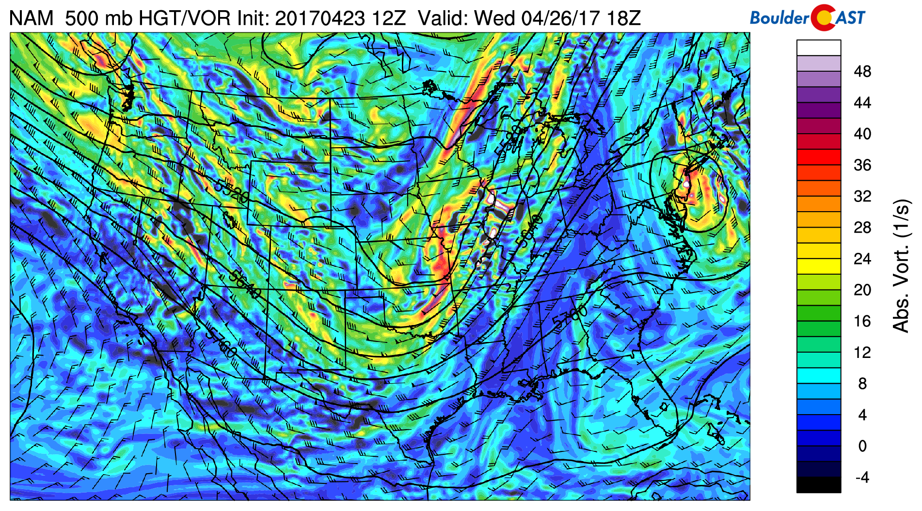
On Tuesday, chillier air filters in, and the threat of unsettled weather increases. First, the pattern is depicted below, showing a trough centered over western Nebraska, with pieces of energy rotating around the base over Utah and southwestern Colorado. The shortwave over western Colorado and Utah is what will be responsible for the lift Tuesday evening.
NAM 500 mb absolute vorticity for Tuesday
In addition, in the low-levels, temperatures will be colder, thanks to a cold front which passes through Monday night and a second one Tuesday evening. Furthermore, upslope flow tied to the secondary cold front will combine with the shortwave discussed above to produce rain showers over the Plains. The track of the storm is mostly south of Denver, so we’re not expecting a major impact. Highs on Tuesday will top out in the upper 50’s so any precipitation will stay in the form of rain. The Foothills, however, could see a mix of rain and snow, with very little if any accumulation.
NAM model 700 mb (left) and 800 mb (right) temperature and wind for overnight tonight
Over the High Country, the precipitation will fall as all snow. The NAM model is predicting anywhere from 4-8″ of snowfall for areas along and west of the Divide. If you haven’t called it quits for your ski season, Wednesday would be an decent powder day!
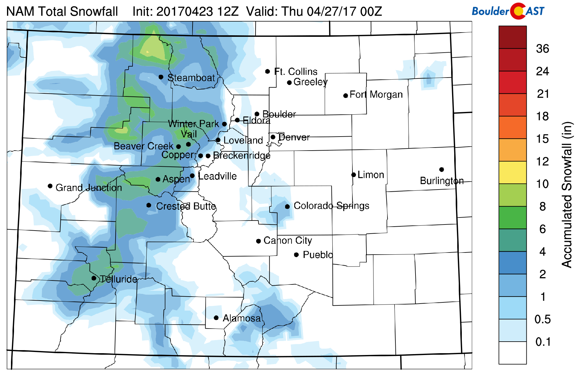
NAM model forecasted snowfall through Wednesday
Wednesday cool with a chance of isolated showers
On Wednesday, the aforementioned trough advects to the east over Missouri. To its west, northwest flow ensues over Colorado on Wednesday with embedded shortwaves. With cold air in place from the secondary cold front Tuesday night, temperatures will remain in the mid to upper 50’s. In addition, cloud cover will be a factor. The embedded shortwaves and some instability being predicted in the forecast models will produce scattered light showers during the late afternoon/early evening, with a rumble of thunder possible. Not much measurable precipitation, however, is expected.
NAM 500 mb absolute vorticity for Wednesday
Cold weather to end the week…and maybe snow?
As we move toward Thursday and Friday, northwest flow will remain anchored across our beautiful state. That will keep the cold air in place across the region. Furthermore, Pacific moisture will continue to pump in leading to the chance of showers. However, it appears that our best threat of late-week precipitation will come late Friday night or Saturday. Depicted below is the GFS 500 mb mid-level pattern for Saturday. It shows an impressive area of low pressure centered near the Four Corners region. This is a classic late-season storm track for snowfall. And if you haven’t already noticed, the position of the storm is eerily similar to the three or so storms we had in March. Just like those storms, this one may be too far south as well…time will tell.
In any case, it appears we will again be dealing with a southern storm track for this event. While we are more than five days out, its too early to tell how much precipitation will occur and whether we will see rain or snow. One thing is certain, temperatures are going to be cold in the low 50’s Friday and likely upper 30’s to low 40’s Saturday and Sunday.
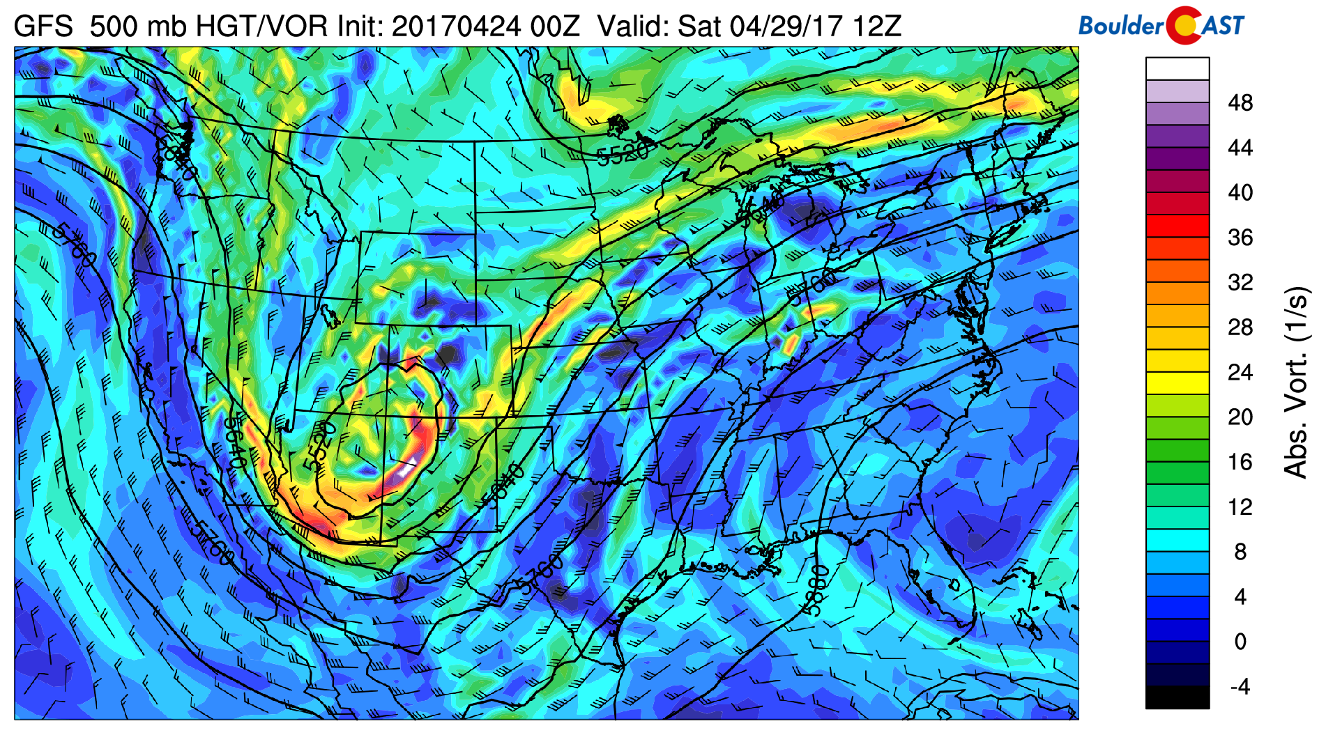
GFS 500 mb absolute vorticity for Saturday
Current forecast models are hinting at measurable snowfall from Friday night through Sunday (see below). The grey lines indicate individual model forecasts, with the mean in black and the deterministic GFS model in blue. A wide range in snow totals is evident, with a split of 0″ to over 20″. The deterministic GFS hints at up to 18″. The mean is around 6-8″. As we all learned in March, we are not going to get too excited about this storm until we get closer – the GFS model has over-predicted much of these southern track storms lately. If things continue to materialize, we’ll certainly provide you a detailed forecast late in the week so stay tuned…
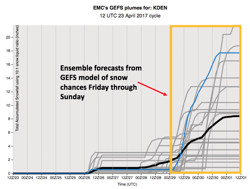
GEFS ensemble range of predicted snowfall for the upcoming weekend
Forecast Specifics:
Monday: Mostly cloudy skies with few isolated showers during the evening hours and overnight. Highs in the upper 60’s for the Plains and in the upper 50’s in the Foothills.
Tuesday: Partly to mostly cloudy. Widely scattered showers developing by late afternoon/early evening, with a mix of rain and snow in the Foothills, especially south of Denver. Temperatures will be chillier in the upper 50’s across the Plains and in the upper 40’s in the Foothills.
Wednesday: Partly sunny skies becoming mostly cloudy by late afternoon with a few isolated thundershowers by early evening. Highs in the mid to upper 50’s for the Plains and middle 40’s in the Foothills.
Thursday: Partly sunny skies in the morning and afternoon, then increasing clouds with a slight chance of isolated thundershowers in the early evening. Temperatures will peak in the upper 50’s across the Plains, with mid 40’s in the Foothills.
Friday: Mostly cloudy skies. We are mainly dry for much of the day, however rain and snow showers are possible as early as Friday evening. High temperatures will be in the low 50’s across the Plains and near 40 in the Foothills.
High Country / Ski Resorts: On Monday, 1-4″ of fresh powder is possible with a wave of energy traversing from west to east. A better chance of snowfall exists Tuesday afternoon/night with a general 3-6″ expected across several ski resorts. Wednesday looks like a superb powder day! On Thursday, the chance of snow continues, although the next bigger threat will occur Friday night through Sunday, with the potential of 6+ inches.
Weekend: A large degree of uncertainty exists for the upcoming weekend. It will all hinge on the track of a southern storm system. One thing is certain: the pattern will be colder and temperatures likely falling to the upper 30’s and low 40’s for highs over the weekend. The threat of rain/snow is something to watch for sure, but the devil is in the details so no guarantees this far out.
Mon
Tue
Wed
Thu
Fri


Temperature
67
57
58
57
52


Precip Chc (Plains)
20%
20%
20%
10%(pm)
30%


