Following a quick taste of winter Sunday night, our weather takes a turn for the better with warmer and drier conditions ensuing this week. We discuss the snow totals from Sunday night and look ahead to possible record warmth later this week into the weekend.
This week’s highlights include:
- A recap of the convective snow showers that dropped several inches of snow Sunday evening
- Low clouds, flurries and cold linger Monday morning
- A ridge builds in slowly through the week leading to completely dry conditions
- Springlike temperatures expected much of the week, approaching record warmth Friday/Saturday
- No chances for snow in the Mountains until the weekend
DISCLAIMER: This weekly outlook forecast is created Monday morning and covers the entire upcoming week. Accuracy will decrease as the week progresses as this post is NOT updated. To receive daily updated forecasts from our team, subscribe to BoulderCAST Premium.

March comes in like a lion
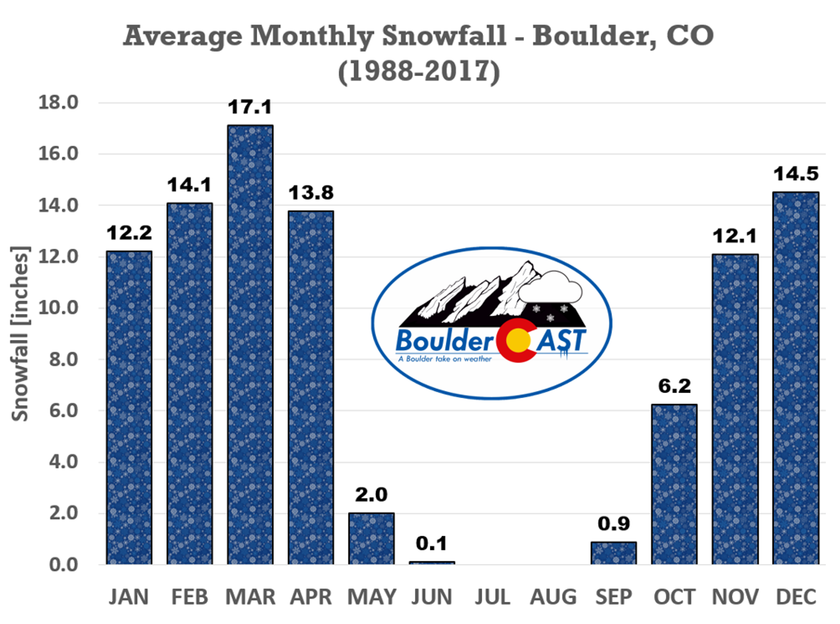
Welcome to our snowiest month of the year! Wait, you did know that March is climatologically the snowiest month of the year in both Boulder (and Denver) didn’t you? Over the last 30 years or so, Boulder has averaged around 17″ of snow in the month of March. While warmer temperatures and blossoming trees may be on your mind, we’ve still got a lot of winter weather to go! Yesterday’s brief tango with snow was a well-timed reminder of this.
Shown below is the water vapor satellite animation from GOES-East as of Monday morning. The two (yes two!) storm systems related for our snow Sunday evening are clearly evident. The main cut-off low is located near San Diego, while a beautiful comma-shaped cyclone is spinning north of the Great Lakes in Canada. Linking these two systems is an elongated trough axis stretching directly across Colorado. A line of drier (sinking) air just behind this trough axis is visible connecting the two aforementioned low pressure systems.

GOES-East water vapor animation from Monday morning
Sunday’s snow event was definitely unique for this time of year. Neither of the two storm systems came within 1,500 miles of Denver. However, the atmospheric set-up between them set the stage for an afternoon and evening of scattered heavy snow showers across much of Colorado and Wyoming. As we discussed in our forecast, there was some 350 J/kg of convective available potential energy (CAPE) across the Mountains and Foothills Sunday afternoon. This led to an explosion of convective cells that progressed eastward across the Front Range through the evening. The GOES-East infrared satellite animation from Sunday afternoon and evening shows the developing heavy snow showers across the area (see below). Brighter colors indicate colder and thus higher cloud tops, speaking to the unstable atmospheric set-up. March convection isn’t terribly abnormal for our area (the sun is becoming stronger with each passing day), but considering the sub-freezing surface temperatures in the Denver Metro area when it was happening, it was quite a treat to see.
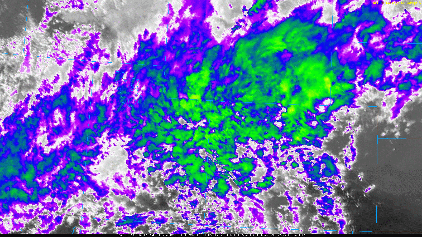
GOES-East infrared satellite animation from Sunday afternoon and evening showing convective development across Colorado
Shown below is our snowfall forecast map issued Sunday morning with actual storm totals overlaid in boxes. Green boxes indicate that our forecast verified to within one inch of the observed snowfall. Red did not.

Similar to a typical monsoon convection day in the summertime, snowfall amounts varied quite a bit across the region due to the popcorn nature of the snow showers Sunday evening. We tried to account for this in our forecast, but ultimately we came in just a little too high. Snowfall amounts generally ranged from 1-4″ across the Metro area. Boulder came in around 4″, while Denver International Airport reported the lowest total of the entire area, just 0.5″! If your location saw less than 1″ of snow, that means you managed to dodge most if not all of the convective snow showers and you should probably take that luck to Vegas! The pocket of heaviest snow (5-7″) ended up just south of our forecast domain in the Palmer Divide/Colorado Springs region.
| Seasonal Snow Totals (Updated March 2 2020) |
|---|
| Boulder | Denver |
|---|---|
| 98.4" | 41.7" |
By the way, lightning detection networks did pick up about a dozen rumbles of thunder across Colorado Sunday afternoon and evening accompanying the snow. So we did have some thundersnow. None of the strikes occurred across the populous Denver Metro area, however. The closest bolts were near Sugarloaf west of Boulder, another near Eldora, one around Idaho Springs, and also near Vail.
A tease of spring this week
You won’t find any snow in the forecast the rest of the week! The pattern is changing for us with a long duration ridge of high pressure set to develop across the western United States. The atmospheric set-up at 500mb for Monday morning is shown below. We still have that pesky and elongated trough axis lingering across the area connecting our two storm systems. The cut-off low now positioned in southern California will drop further southeast through Mexico over the next few days. This won’t be a concern for us at all.
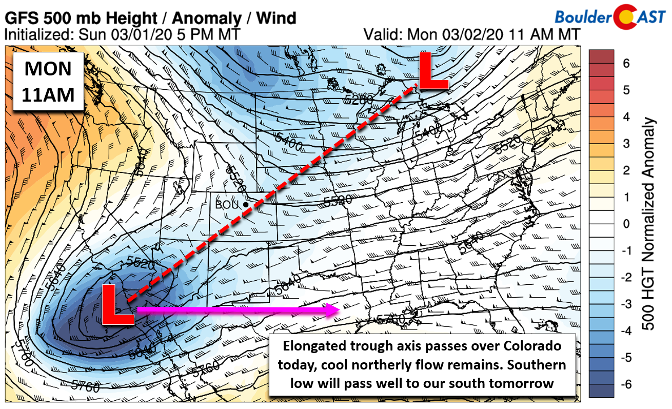
The biggest weather player this week for us is the incoming ridge of high pressure seen above just offshore from the Pacific Northwest. This ridge will eventually push into the Rockies and intensity later this week. The GFS model 500mb height anomaly animation below loops from Monday into Friday night. Watch as the ridge south of Alaska moves east, weakens, and then re-intensifies over Colorado.
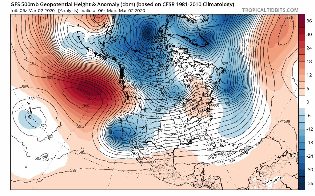
GFS 500mb height anomaly forecast animation covering Monday into Friday. A ridge takes hold across Colorado
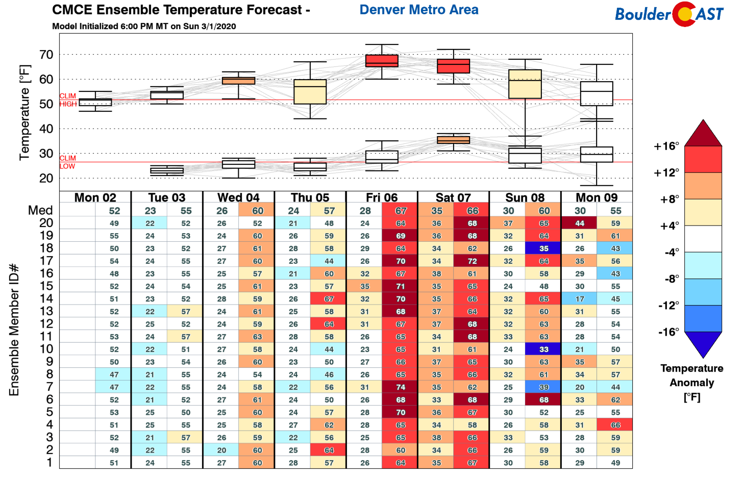
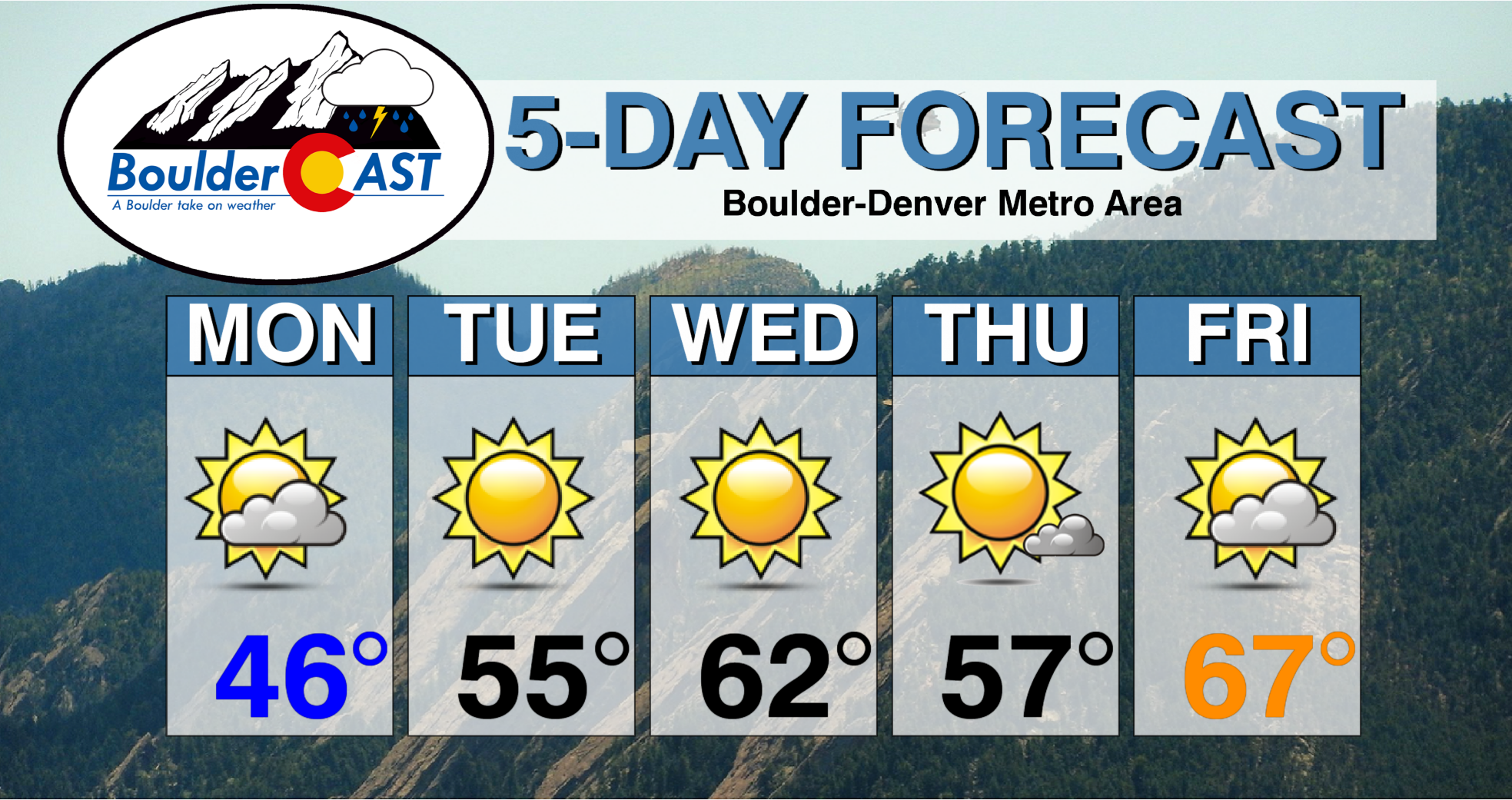
This will spell out a rather quiet week for us with warming temperatures and dry conditions. The only slight cause for concern this week comes in the form of an embarrassingly dry cold front early Thursday. This won’t do much more than put a one-day setback to our springlike thaw. Otherwise, we’ll see highs push from the 40’s Monday, into the 50’s and 60’s Tuesday and beyond. As the ridge fully takes hold Friday into the weekend, temperatures will really take off. We could possibly get close to record warmth, around 70 degrees.
On a similar note, warm and dry conditions across the Metro area will be accompanied by a serene week in the Mountains with lots of sunshine and temperatures near or slightly above normal. Outside of a few residual snow showers early Monday morning, almost no snow is expected the rest of the week statewide. PowderCAST is picking up some powder for the weekend, mainly in southern Colorado, but we’re not fully convinced yet on that.

Luckily, snowpack is relatively healthy statewide. The Mountains can endure a few more ridges before you can color us concerned. That’s all for now. Enjoy the taste of spring this week….it certainly won’t last.

Forecast Specifics:
Monday: Morning low clouds, patchy fog, and isolated flurries. Skies then turn partly cloudy with highs in the upper 40’s on the Plains and middle 30’s in the Foothills.
Tuesday: Sunny and mild with highs in the mid to upper 50’s on the Plains and 40’s in the Foothills.
Wednesday: Sunny and warmer with high temperatures in the lower 60’s across the Plains and upper 40’s in the Foothills.
Thursday: Mostly sunny and dry but slightly cooler. Highs in the mid to upper 50’s on the Plains and middle 40’s in the Foothills.
Friday: Increasing clouds with springlike warmth. Highs in the middle to upper 60’s on the Plains and lower 50’s in the Foothills.
High Country: A few lingering snow showers across the Mountains are expected early Monday morning. Otherwise, it will be a dry, sunny, and mild week across the Mountains. There are some hints of snow returning to the state this weekend, but uncertainty is elevated. Check our PowderCAST page for always-updated weather forecasts for all of the Colorado ski resorts.
Help support our team of Front Range forecasters by joining BoulderCAST Premium. We talk Boulder and Denver weather every single day. Sign up now to get access to our daily forecast discussions each morning, complete six-day skiing and hiking forecasts powered by machine learning, first-class access to all our Colorado-centric high-resolution weather graphics, bonus storm updates and much more! Or not, we just appreciate your readership!
.
Spread the word, share our forecast!


You must be logged in to post a comment.