
The month of June starts out very warm with temperatures in the high 80’s to near 90 degrees each day. Along with the heat, there will be a persistent but minor threat of thunderstorms each day through the week. We also discuss the outlook for the month of June as a whole.
This week’s highlights include:
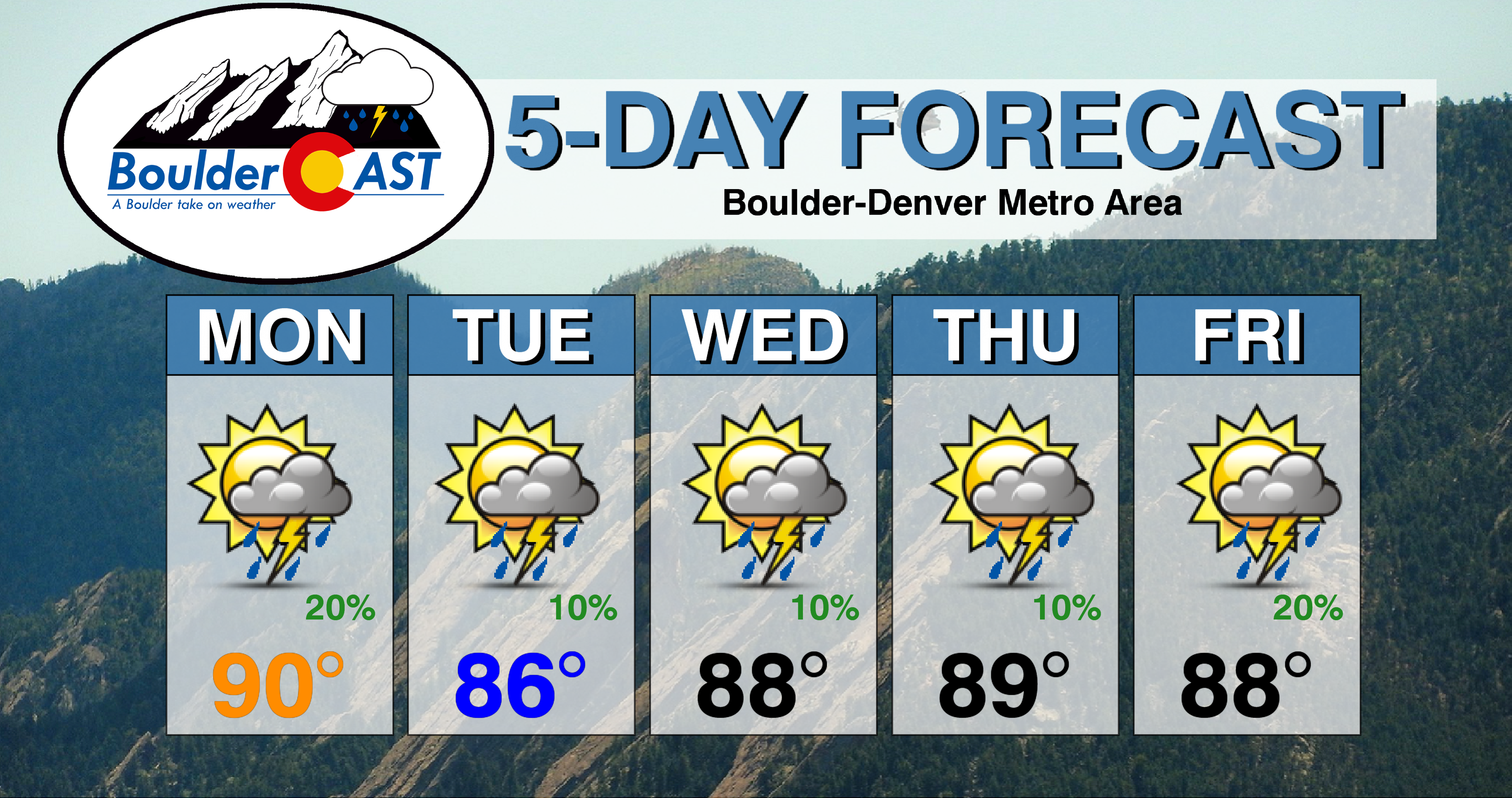
- Highs in the middle 80’s to lower 90’s throughout the week
- 10-20% chance of storms each day but nothing widespread
- Watching a late-week system that could impact the upcoming weekend with more fruitful rainfall
- June 2020 looks to be a hot one!
DISCLAIMER: This weekly outlook forecast is created Monday morning and covers the entire upcoming week. Accuracy will decrease as the week progresses as this post is NOT updated. To receive daily updated forecasts from our team, subscribe to BoulderCAST Premium.

Much of the same to start the week
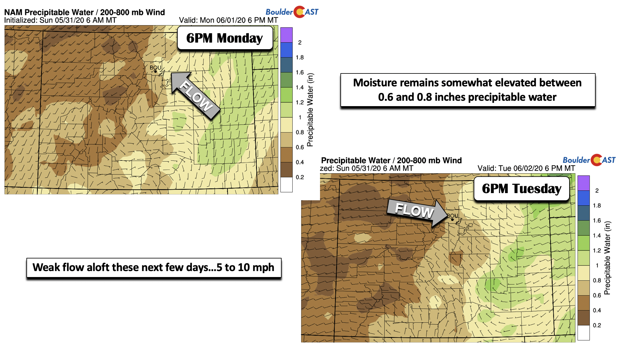
The week starts out similar to where we left off on Sunday…the last day of May. The airmass is virtually unchanged albeit a tad warmer in the low-levels. These next few days, we are watching a weak circulation of low pressure over southern Colorado (below). The position of the system today will favor weak upslope flow both aloft and at the surface. This system, along-side the warm and moistened airmass, will support that continued 20% or so chance of storms this afternoon into evening. Morning sunshine will give way to increasing clouds.
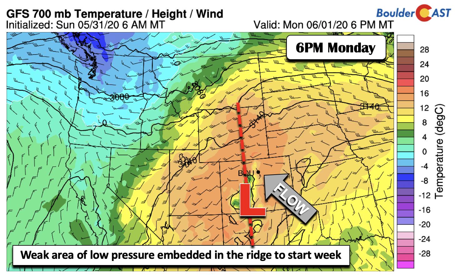
If Boulder hits 90°F on Monday, it will be a new record high for June 1st (current record 89°F from 1997).
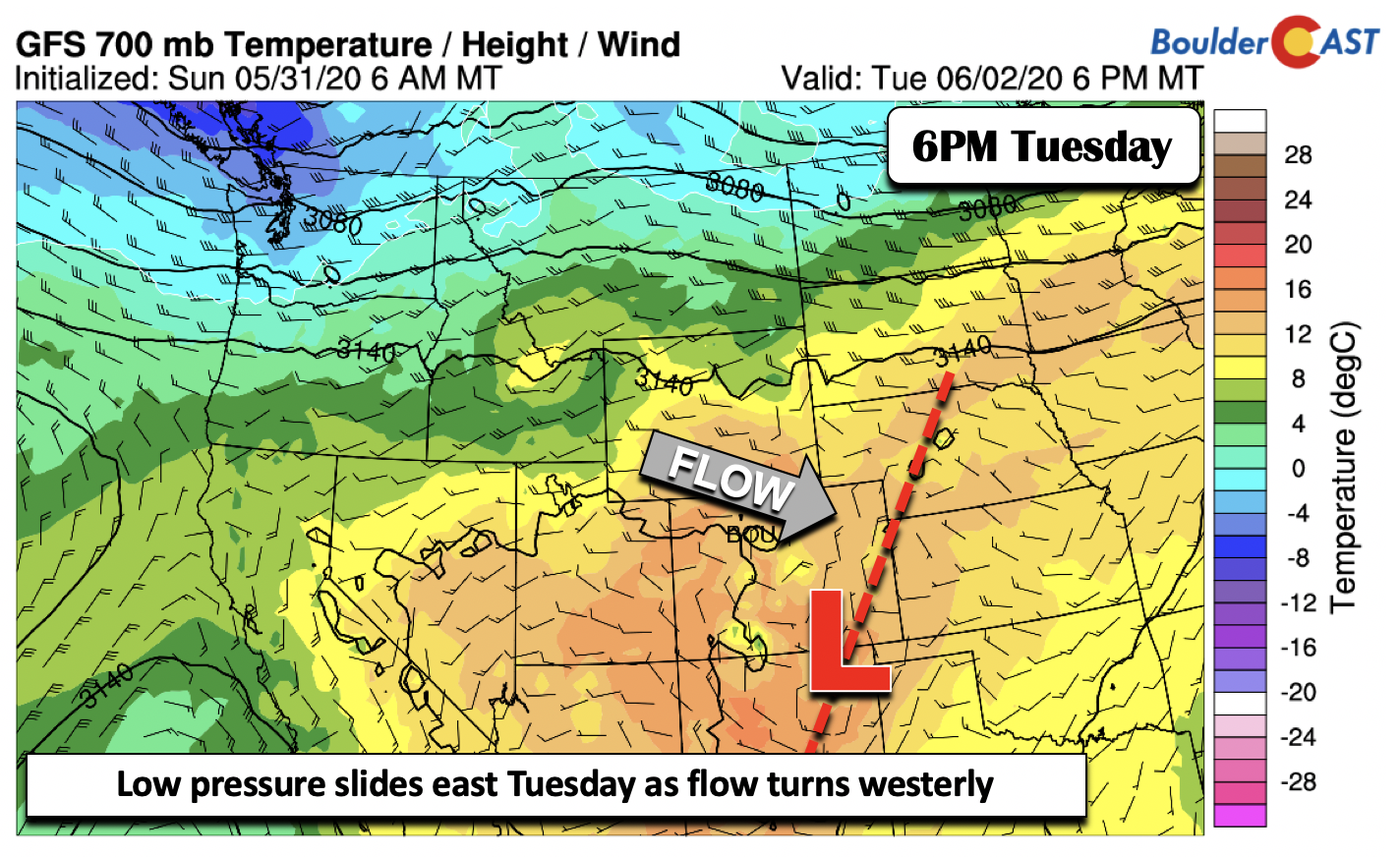
Tomorrow, the trough axis and circulation drifts slowly to the east-southeast into northern New Mexico (below). That allows the flow to become westerly over our area. This in essence will weaken the threat of storms somewhat but a 10% chance remains in the cards. Look for highs once again in the 80’s across the Denver/Boulder area.
The flow aloft these next few days is quite weak, only 5 to 10 mph in the mid-levels (below), out of the east-southeast today and the west tomorrow. The precipitable water, a metric we use to gauge moisture content, remains elevated as well in the 0.6 to 0.8 inch range, warranting that continued chance of isolated to widely scattered storms. However, the storms that do pop will be slow to move after forming over the High Country and Foothills, but they will slowly drift eastward towards the Plains. Considering the weak steering flow, isolated flash flooding is possible, with the greatest threat being across the burn scars in the higher terrain.
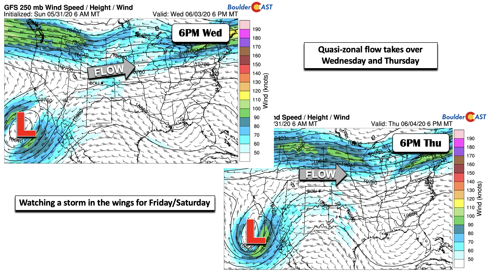
Flow turns zonal (westerly) midweek
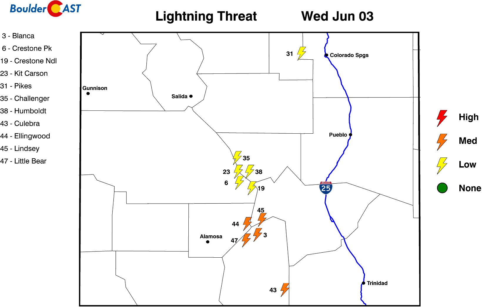
As we go into Wednesday and Thursday, the atmosphere shifts to a more-or-less zonal (westerly) flow aloft, becoming west-southwest Wednesday (below left) and westerly Thursday (below right). This flow pattern should allow for more dry time and less coverage of storm activity with downslope taking over. Though with moisture still remaining elevated, we still can’t rule out that 10-20% chance of late-day storms. The Mountains have the best odds during this timeframe. Shown in the bottom left of each image below is a cut-off area of low pressure that we are watching to take aim on the region for the weekend.
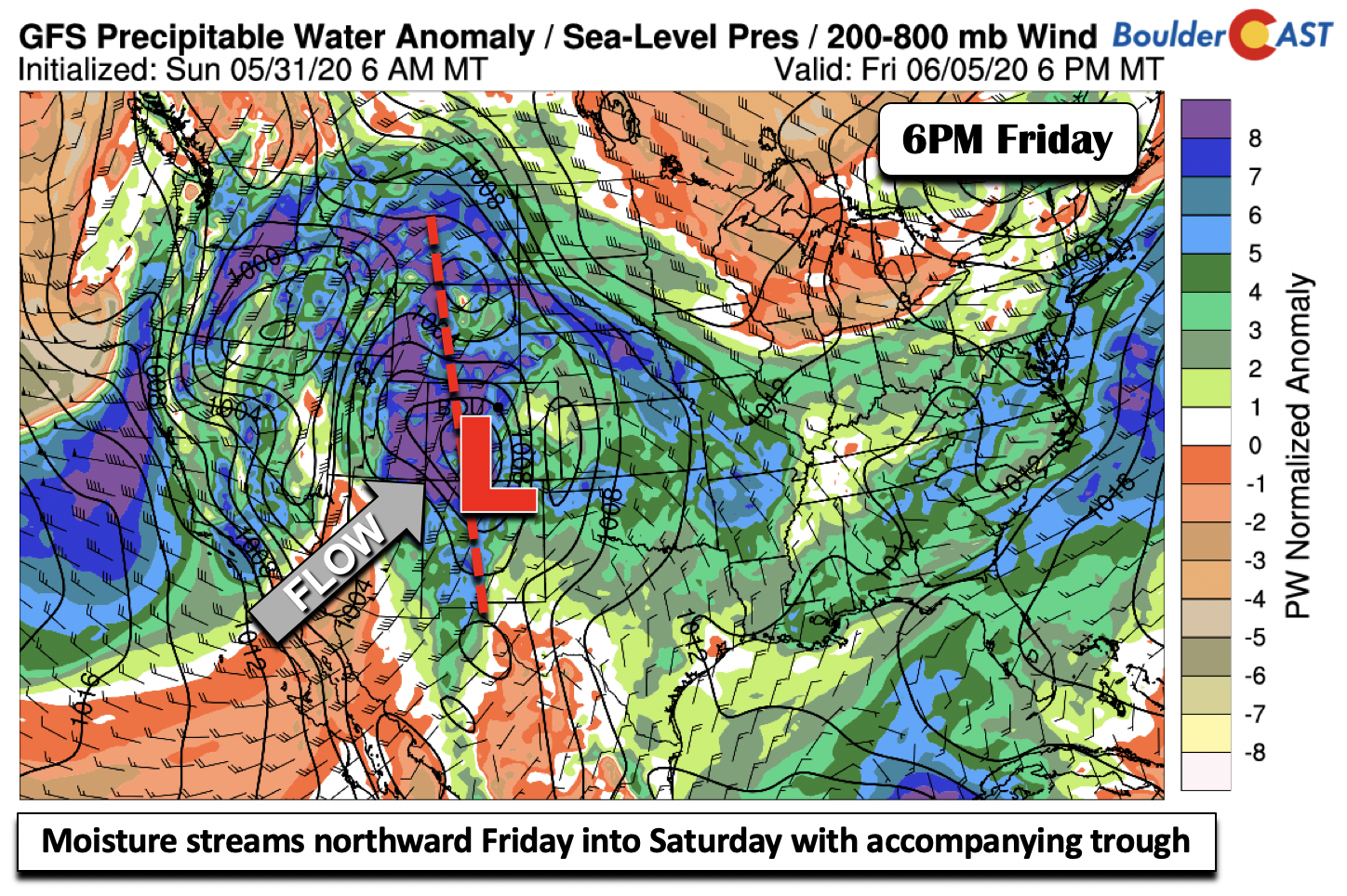
Watching a late-week to weekend storm
As noted, we are watching a cut-off low pressure that is poised to track northeast into the Inter-Mountain west Friday night and Saturday, surging moisture northward with it (below). This should lead to a good threat of showers and storms, though being five days out is tough to say at this point. If things line up right, we could be looking at a more widespread rainfall event for the area.
Outlook for June
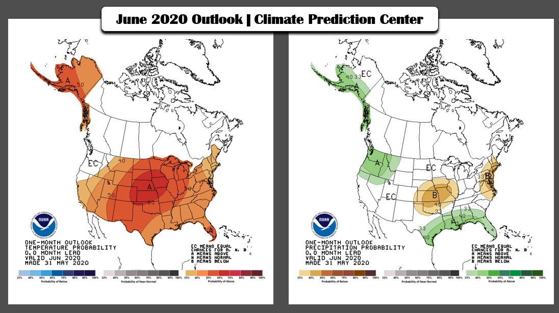
Just yesterday the NOAA Climate Prediction Center released their updated forecast for the month of June (shown below). As you can see, they are predicting around a 60% chance that June will end up warmer than normal in our area. In their discussion, they attribute this mainly to the very warm pattern expected in the first ten days of the month, including the heat we will see this week across the Front Range.
Furthermore, June is Colorado’s most active month for severe weather, with the peak occurring near the middle of the month. We’re talking large hail, damaging winds, and even tornadoes.
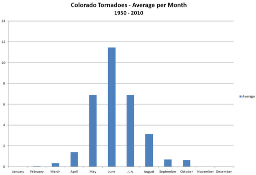
Average tornadoes observed by month in the entire state of Colorado. Data provided by NCDC.
Just five years ago in June 2015 a rotating thunderstorm produced the first ever EF3 tornado in Boulder County along with tennis ball sized hail. Luckily no one was injured as the twister struck in the farmland north of Longmont. Tornadoes this close to the Front Range can be especially dangerous considering the high population density. Usually they form much further east.

3.75″ hail from a storm chase in June 2017 near Cheyenne.
If there is one time of year we all need to be extra aware of the weather around us, it is during the month of June! We’ll be sure to keep you updated if anything materializes for severe weather across our region.
Have a good and cool week ahead!
Forecast Specifics:
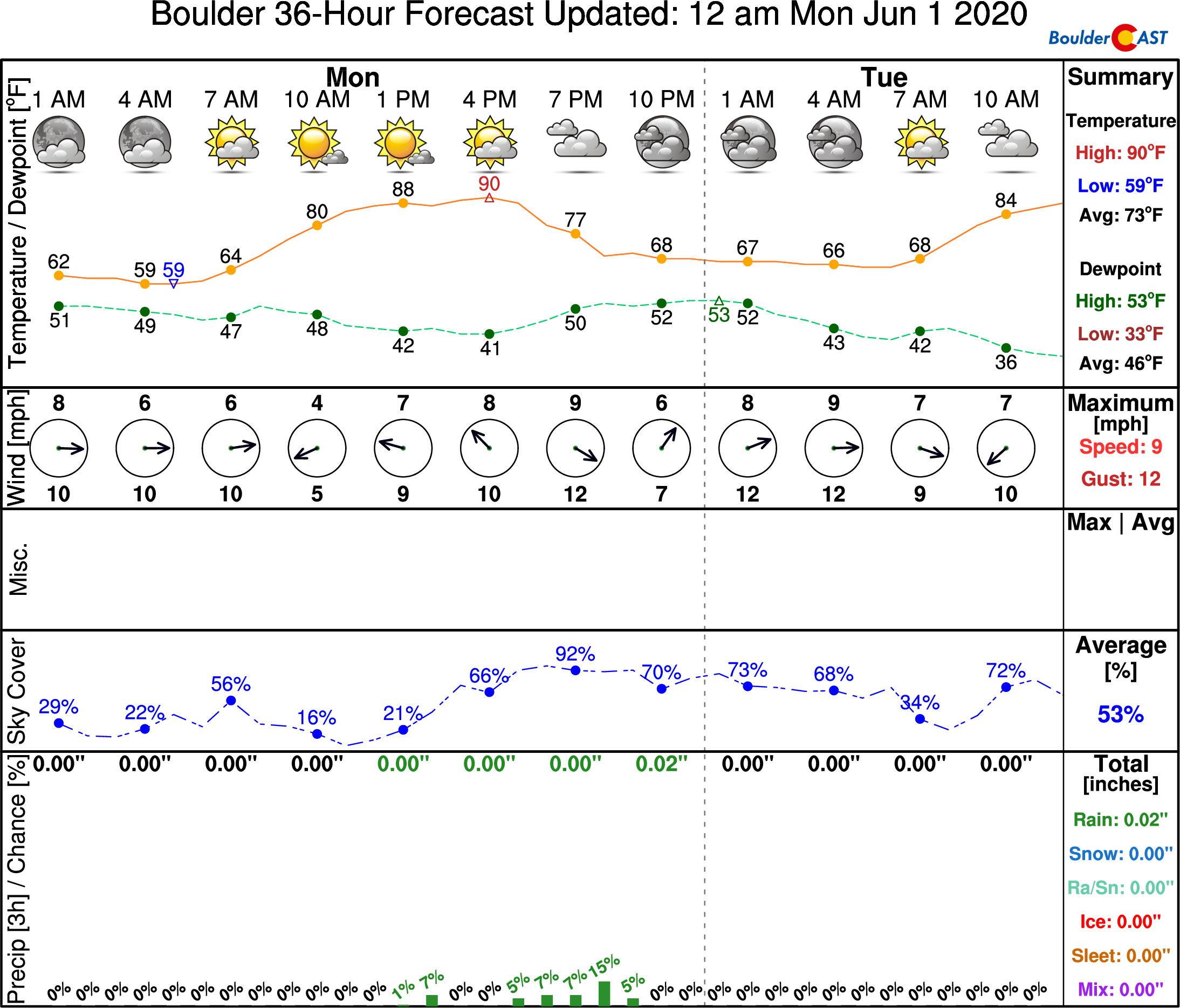
Monday: Morning sun giving way to increasing clouds with a 20% chance of afternoon/evening storms. Weak steering flow will lead to slow-moving storms with localized heavy rainfall. Highs near 90 degrees on the Plains and upper 70’s in the Foothills.
Tuesday: Mostly sunny with a 10% chance of late-day storms, mainly across the higher terrain. Highs in the middle to upper 80’s on the Plains and middle 70’s in the Foothills.
Wednesday: Party sunny skies with isolated afternoon/evening storms with upper 80’s to 90 in the Front Range and upper 70’s in the Foothills..
Thursday: Partly cloudy skies with isolated thunderstorms and temperatures near 90 on the Plains and upper 70’s in the Foothills.
Friday: Sunny skies turning to increasing clouds with a slightly better chance of thunderstorms later in the day. Highs in the upper 80’s to 90 for the Plains and upper 70’s in the Foothills.
High Country: Scattered showers and thunderstorms will persist each day across the higher terrain each day, in that 30-40% chance range with above average moisture in-place. Be sure to get your above-timberline hikes completed by mid-day. Check SummitCAST for daily updated forecasts for more than 120 mountain hiking destinations across Colorado.
We discuss Boulder and Denver weather every single day on BoulderCAST Premium. Sign up today to get access to our daily forecast discussions every morning, complete six-day skiing and hiking forecasts powered by machine learning, access to all our Front Range specific weather models, additional storm updates and much more!
.
Spread the word, share the BoulderCAST forecast!


You must be logged in to post a comment.