
For the upcoming week, smoke and heat will be the main forecast challenges for the period through Friday. A potent ridge of high pressure will largely remain situated over Utah and Colorado, keeping us in a continued hot and dry pattern. Monsoon moisture will return to the area briefly during the middle of the week and also into the weekend, resulting in some storm chances. Read on for our full forecast below.
This week’s highlights include:
- Smoke from wildfires out west will be lingering for the start of the week
- Highs in the lower to middle 90’s most of the week, but perhaps edging towards upper 90’s by week’s end
- Monsoonal moisture nudges up a tad Tue/Wed and again for the weekend, resulting in some storm chances, but the week is largely dry outside of this

DISCLAIMER: This weekly outlook forecast is created Monday morning and covers the entire upcoming week. Accuracy will decrease as the week progresses as this post is NOT updated. To receive daily updated forecasts from our team, subscribe to BoulderCAST Premium.

Smoke & heat headline the early week
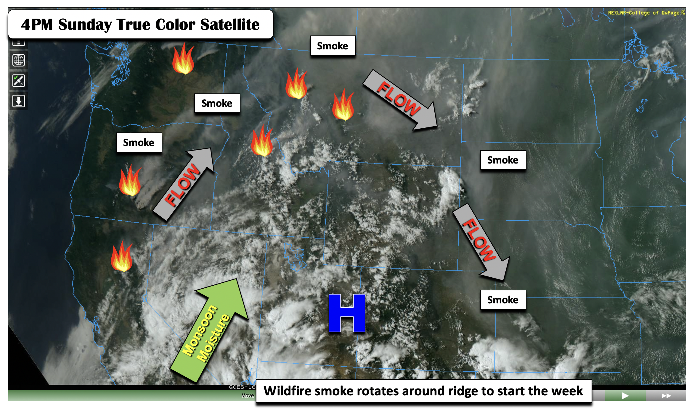
Smoke and heat will start out our week across the Front Range. As a first look, the image below depicts the true color satellite plot as of yesterday afternoon at 4:00 PM over the western U.S. There are a lot of features worth pointing out in the figure, but the main thing is the series of large fires across California, Oregon, Washington, Idaho, and Montana. Although the smoke is not entirely visible at all locations, it is evident as haze. This wildfire smoke is rotating around the ridge of high pressure over eastern Utah and western Colorado. Note how the smoke has reached eastern Colorado yesterday evening, as the flow became more east-northeast. Monsoon moisture is pinned southwest of the ridge over Utah, Nevada, and Arizona.
The HRRR model had a good handle on things yesterday afternoon (below left), showing the smoke reaching eastern Colorado. That smoke will be over the Denver Metro this afternoon as well (below right), as diurnal upslope flow brings in the unhealthy air. Be sure to avoid prolonged time outdoors if you are sensitive to these air quality conditions.

We should see some reprieve in the smoke as the week progresses, but forecasting this will depend largely on the overall flow. Right now our smoke forecast has thick smoke aloft remaining over the area through Tuesday.

Along with the smoke today (as it will be dry with little chance of any rain), temperatures will once again top out in the lower 90’s. These 90+ degree temperatures will be with us through the forecast period, perhaps into the weekend as well as the ridge of high pressure largely remains in place over the Desert Southwest. The GEFS figure below depicts that the hottest days may be Thursday and Friday, but more on that later…

The ridge today remains over western Colorado, with above average heights extending from Colorado into western Canada. A trough axis was positioned over the northeast U.S. into the southern Midwest states. This trough in the East may be a player for us later in the week and especially the upcoming weekend as some models hint that moisture associated with this boundary could retrograde westward into Colorado and increase our storm chances then.

Otherwise, we remain dry on Monday as the monsoon moisture is tucked west of our beautiful state over California into Idaho (below). Note the above average moisture content over the southeastern U.S. associated with the trough axis – something to watch for us later in the week! Highs today will be in the lower 90’s with lots of sunshine as storms remain to our west.

Monsoon moisture builds back in briefly Tue & Wed, but the heat remains
On Tuesday and Wednesday, the ridge center does not change too much, with the circulation positioned over the Four Corners. Heat will remain in place with lower to middle 90’s expected over the Front Range.

However, as the ridge shifts toward the Four Corners Tuesday into Wednesday ever-so-slightly, the monsoonal moisture to our west will translate eastward under an increasingly westerly flow aloft. That will lead to an uptick in storm chances during this time.
Along with the increased moisture, model guidance is showing a weak trough axis or frontal boundary approaching the area late Wednesday afternoon/evening (below). We hesitate to call this a front as there will not be any cold air behind the boundary – there is mainly a wind shift as noted below. The presence of this boundary, along with increased moisture and instability, should lead to a 20-30% chance of afternoon/evening scattered storms on the Plains. However, the main flow will still be downslope so most activity should reside over the higher terrain or far eastern Plains.

The NAM depiction of precipitation chances Tuesday and Wednesday is shown below. These two days will be our best chance of measurable precipitation through Friday. Tomorrow, the storms should be focused over the western part of the state in the Mountains, with the activity shifting eastward on Wednesday with the front and eastward moisture progression.

Dry & hot with mid to upper 90’s possible late in the week
Come Thursday and Friday, little overall mid-level pattern changes are noted. The ridge will somewhat flatten (weaken), with two circulation centers possible over northeast Arizona and another over western Nebraska. A potential low pressure over Texas may be a player for our weekend (below).

With little change in the atmospheric pattern, 700mb temperatures aloft will soar to around 18 to 20°C Thursday and Friday. That should support, with a lack of clouds and storms for this period, mid to upper 90’s across the area. If this comes to fruition, we don’t anticipate any records being broken, as the record highs during this time frame are in the upper 90’s to lower 100’s…but we won’t entirely rule it out either. Only isolated chances of storms are forecast late in the week.

The reason for the lack of storm chances is the ridge, and, secondly, the monsoon moisture again pushing west of the Plains, focused over Utah and the western mountains of Colorado. If you are hiking this week and the weekend, expect your typical daytime shower/storm activity.

A potential return of the monsoon moisture is hinted at in the longer-range models and ensembles by the weekend, as the ridge may shift southward and allow the moisture to build back in from the west. That should lead to, at the very least, an increased chance of storms over the High Country and perhaps the Plains, too. Temperatures should remain in the 90’s across the Plains through the weekend with a lack of any fronts to cool us off.
Stay up to date with Colorado weather and get notified of our latest forecasts and storm updates:
We respect your privacy. You can unsubscribe at any time.
.
Forecast Specifics:
Monday: Mostly sunny, warm and smoky once again with lower 90’s on the Plains and near 80 in the Foothills.
Tuesday: Hazy but sunny skies giving way to increasing clouds with isolated weak storms in the afternoon/evening, mainly across the higher terrain. Highs in the lower 90’s on the Plains and near 80 on the Plains.
Wednesday: Mostly cloudy skies with scattered afternoon and evening thunderstorms. Highs in the low to middle 90’s on the Plains and near 80 in the Foothills.
Thursday: Mostly sunny and hot with highs in the middle 90’s on the Plains and 80 over the Foothills.
Friday: Partly cloudy and hot with isolated storms possible, mainly across the higher terrain. Temperatures in the mid to upper 90’s possible on the Plains and lower 80’s in the Foothills.
Mountains: It will be a week of off and on scattered showers and storms over the higher terrain. The storm chances will be confined to the western part of the state on Monday. Tuesday and Wednesday, the storm chances will shift eastward into the central portion of the state. By week’s end, the storms will largely be placed over the west and southwest part of the mountains once again. The upcoming weekend will favor storms over most of the High Country with monsoon moisture around and favorable lift with daytime instability.


Help support our team of Front Range weather bloggers by joining BoulderCAST Premium. We talk Boulder and Denver weather every single day. Sign up now to get access to our daily forecast discussions each morning, complete six-day skiing and hiking forecasts powered by machine learning, first-class access to all our Colorado-centric high-resolution weather graphics, bonus storm updates and much more! Or not, we just appreciate your readership!
.
Spread the word, share the BoulderCAST forecast!
.


You must be logged in to post a comment.